Explore the dynamic weather patterns affecting Chicago and the Midwest, from sizzling temperatures to severe storms.
Get the scoop on Chicago’s current weather conditions with our latest analysis on temperature fluctuation and storm alerts.
This week in the Midwest, especially in Chicago, the weather toggles between extremely high temperatures and intense storm activities. As we dissect the shifting skies and what they mean for your weekend plans, stay tuned for daily updates, safety tips, and more on our comprehensive weather blog. Read more about the detailed forecast, safety precautions during severe weather, and tips for coping with extreme temperatures at https://amyfreeze.ai/.
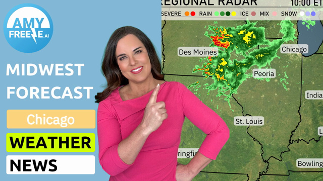
Over the Midwest, we see a vibrant line of severe storms centered around Des Moines, extending into northern Missouri, bringing intense rainfall and potential severe weather. As these storms advance, rain showers are trailing into central Iowa, with lighter showers spotted near Peoria. The rest of the region from Springfield to Chicago remains mostly clear, set under partly cloudy skies. In contrast, the area around Bowling Green, Columbus, and Charleston sees minimal cloud cover, enjoying calm and clear conditions.
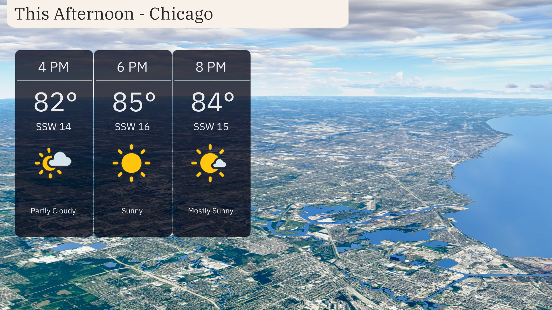
Afternoon temperatures in Chicago soar to a warm 82 to 85 degrees under sunny to mostly sunny skies. Expect a steady south-southwest wind at 14 to 16 miles per hour, providing a gentle breeze throughout the afternoon.
Today’s high temperatures across the Midwest are sizzling. In Des Moines, we’re looking at a sweltering high of 96 degrees, while Kansas City follows closely with a high of 95. St. Louis will reach 93 degrees, and Peoria sees a warm 90. To the north, Chicago has a more comfortable high of 86, and farther east, Indianapolis will hit 85. The contrast in temperatures can be felt in Fort Wayne with a high of 82 degrees, providing some relief from the heatwave dominating much of the region.
Tonight, Chicago will see a low of 79 degrees, while Indianapolis is expected to drop slightly to 77. In St. Louis, temperatures will cool down to 76 degrees. Columbus will sit at 74 degrees, and Charleston will reach a mild low of 69.
Tomorrow in the Midwest, we’re looking at some sizzling temperatures. Des Moines will hit a hot 97 degrees, while Kansas City isn’t far behind at 95. St. Louis is anticipating a high of 98, making it one of the warmest spots in the area. Chicago will also see warmth, with a projected high of 96 degrees. Expect temperatures to be significantly above average, driven by a strong ridge of high pressure dominating the region.
A low-pressure system moves through the Midwest, bringing showers and thunderstorms from St. Louis to Chicago overnight. A cold front arrives over Des Moines and Peoria by Friday afternoon, triggering stronger storms and possibly severe weather with gusty winds. Cooler air filters in behind the front, lowering temperatures by 10 degrees into the weekend for cities like Indianapolis and Columbus.
Today’s UV index in Chicago is moderate at 5, with risks of sunburn in about 27 minutes when exposed directly. As you step into your Saturday, expect a very high UV index of 9, reducing burn time to just 15 minutes.