Chicago’s Scorching Summer Days: Your Complete Weather Guide
By
Amy Freeze
From crystal clear skies to impending thunderstorms, explore a detailed forecast of what Chicago and the wider Midwest can expect this summer. Stay prepared and informed!
Chicago is heating up with temperatures reaching the high 90s. Clear skies dominate today, but thunderstorms are on the horizon. Learn how to prepare for the heat and potential storms this week.
https://www.youtube.com/watch?v=iRmafmje3o0
Welcome to ‘Chicago’s Scorching Summer Days’. This week in Chicago promises clear and sunny weather, perfect for outdoor activities. However, a band of thunderstorms moving east might affect your plans. This article delves into daily forecasts, including temperature trends and storm warnings for the Midwest. Discover how to enjoy the summer safely while staying prepared for any weather changes. Detailed insights into each day’s weather from Sunday to Saturday are provided, ensuring you are always one step ahead.
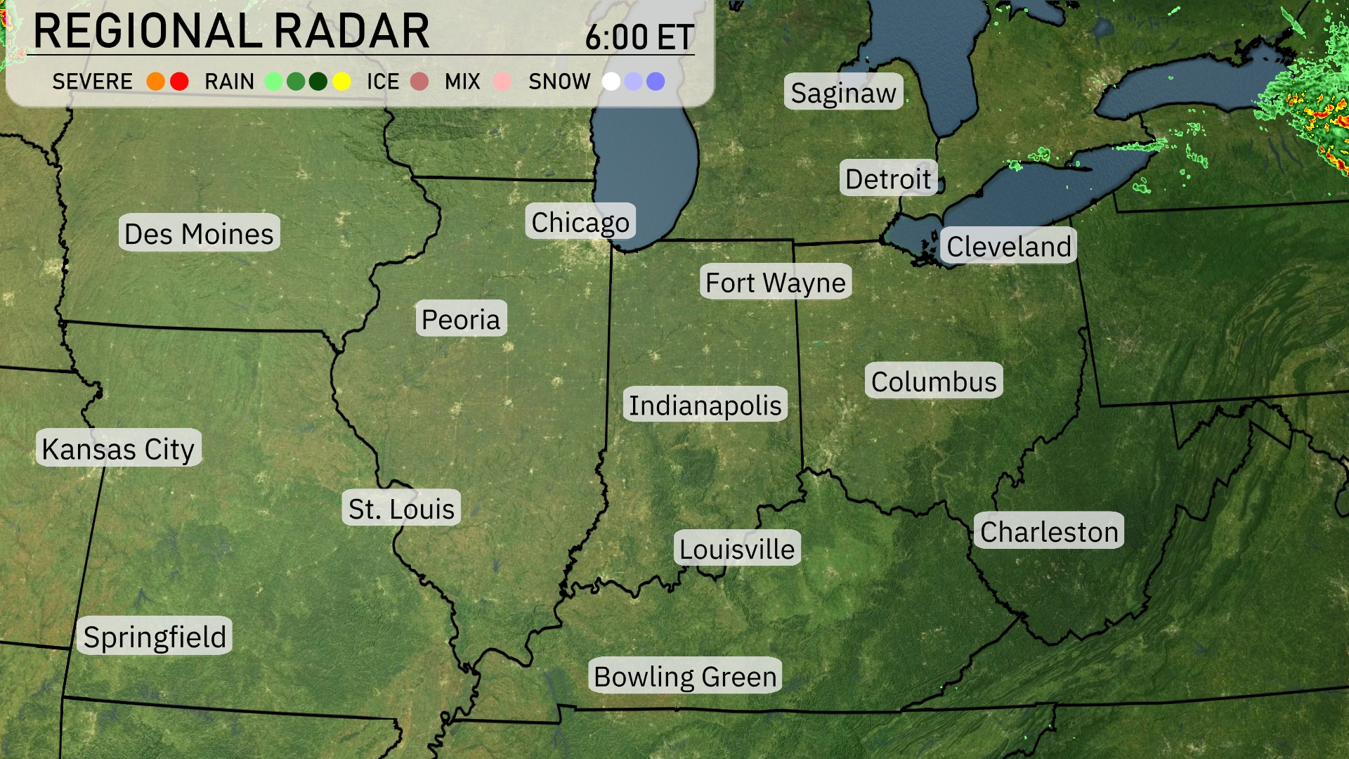
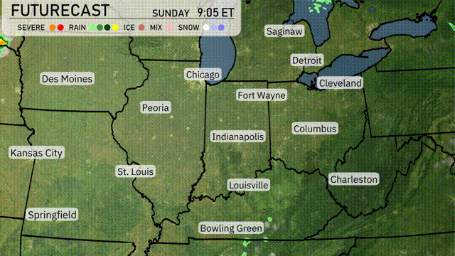
The radar for the Midwest region shows a band of thunderstorms moving eastward starting from Detroit toward Cleveland, closely watching for lightning and strong winds in those areas. A cloud cover persists over Fort Wayne and Indianapolis, although not currently producing precipitation, suggesting a potential for development later in the day. To the north, areas like Saginaw are experiencing clearer skies, providing a respite from the recent unsettled weather. On the western front, Chicago remains dry under clear conditions, with no significant weather activity at this time.
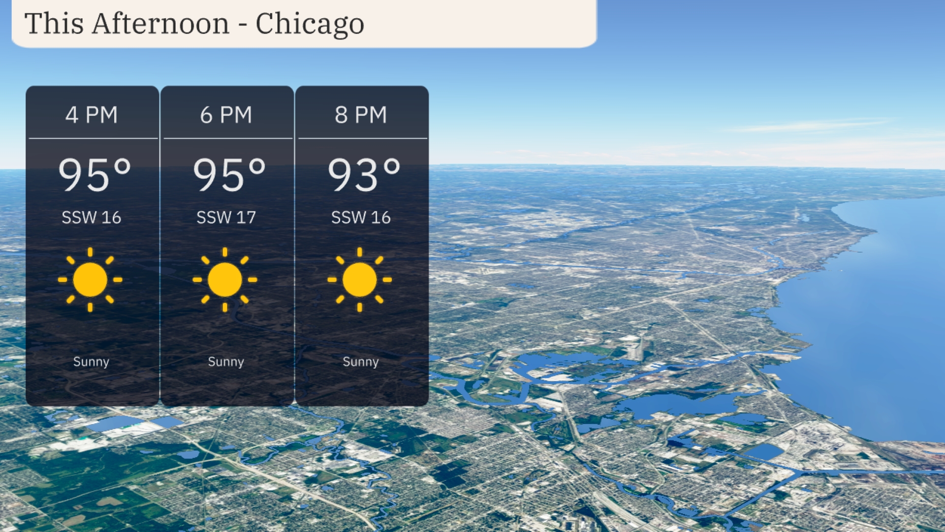
Chicago will experience a hot afternoon with temperatures reaching up to 95 degrees. Expect sunny skies with a steady south-southwest wind around 16 to 17 miles per hour. With clear weather, it’s a great time to enjoy outdoor activities but remember to stay hydrated. As the evening approaches, temperatures will slightly drop to 93 degrees but remain warm and sunny.
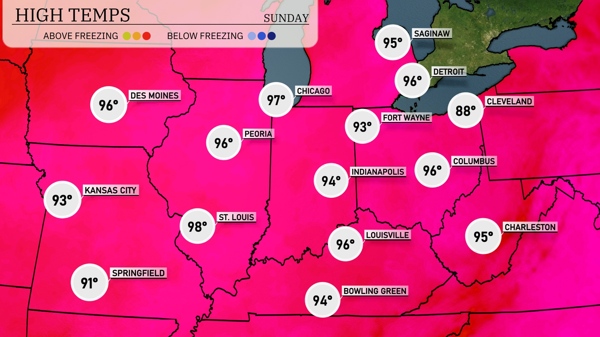
Today’s high temperatures in the Midwest are heating up. Chicago is forecasted to hit a sizzling 97 degrees, while nearby Des Moines reaches a warm 96. Over in St. Louis, the temperature climbs to 98, making it one of the hottest spots in the region. Indianapolis and Louisville will both see highs around 94 to 96 degrees, providing a toasty afternoon for residents. Cleveland enjoys a slightly cooler day at 88 degrees, creating a notable contrast with its neighbors.
Tonight in the Midwest, temperatures will drop significantly with St. Louis settling at 60 degrees. Major cities like Indianapolis and Chicago will see lows of 62 and 63 degrees, respectively. Kansas City is forecasted to dip to 63 degrees.
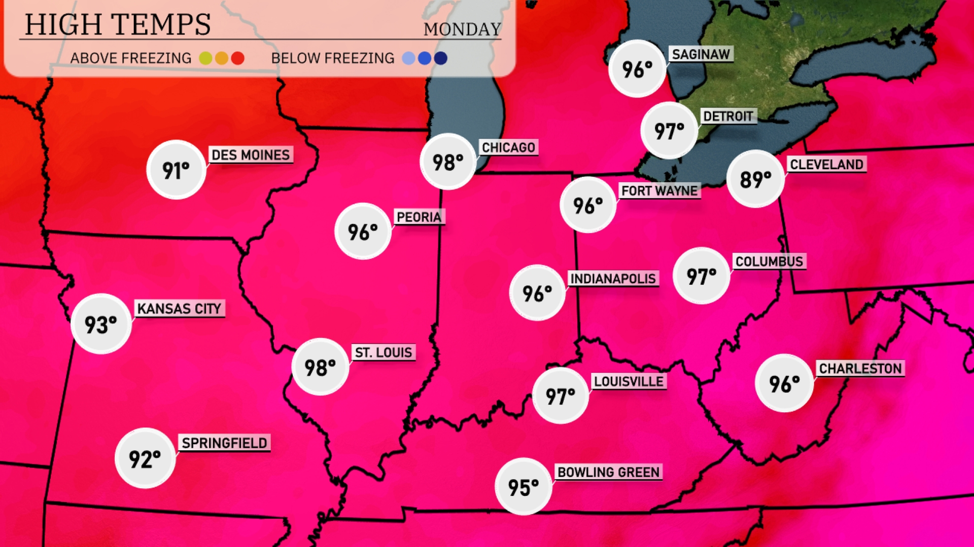
Tomorrow, Chicago is set to soar to a high of 98 degrees, closely followed by Peoria and St. Louis, both reaching 98 and 96 degrees respectively. Indianapolis and Louisville will see highs of 96 and 97 degrees, making it a sweltering day across many Midwest cities. The warm temperatures are significantly above the seasonal averages, driven by a persistent warm front in the region. Kansas City will experience a high of 93 degrees, while Cleveland remains cooler at 89 degrees as it feels the effects of a nearby cold front.
A low-pressure system will sweep through the Midwest tomorrow, bringing scattered thunderstorms from St. Louis to Chicago. The primary threat includes strong winds and localized heavy downpours, with the risk of flash flooding in low-lying areas. Temperatures will drop slightly behind the front, offering a brief respite from recent highs. Columbus and Cleveland will see rain showers lingering into the evening. Be mindful of travel disruptions, particularly on the 70 and 75 corridors.
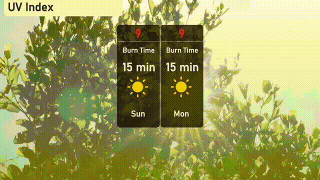
The UV index in Chicago will be very high today with a score of 9, leading to a burn time of about 15 minutes, so it’s important to apply sunscreen frequently and wear protective clothing. Monday follows the same high UV level, maintaining the 15-minute burn time in direct sunlight.