NYC Weather Watch: From Sunny Days to Thunderous Nights
By
Amy Freeze
Experience a meteorological rollercoaster this week in NYC with our detailed weather insights. Here’s what to expect from sunshine to storms.
Unpack a full week of weather dynamics in NYC! From a high of 92°F to early thunderstorms, we cover what to expect and how to stay prepared.
Welcome to your comprehensive guide to this week’s weather in NYC. Starting with warm conditions peaking at 92°F, the city will transition through thunderstorms by the weekend. Prepare for fluctuating temperatures and significant weather shifts. Stay tuned for daily updates and safety tips from Amy Freeze.
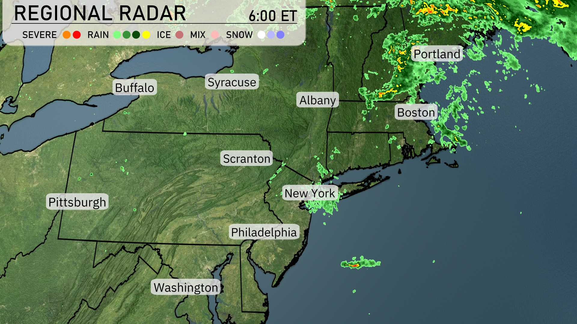
A band of rain is sweeping across the northeastern portion of New England, extending from Portland to the coastal areas, bringing consistent precipitation to those regions. The radar indicates mostly clear skies for New York City, Albany, and Syracuse, providing a dry start to the day. Some isolated showers are observed off the coast southeast of New York. Boston is seeing a break from the rain, although areas just to its north are experiencing scattered rainfall.
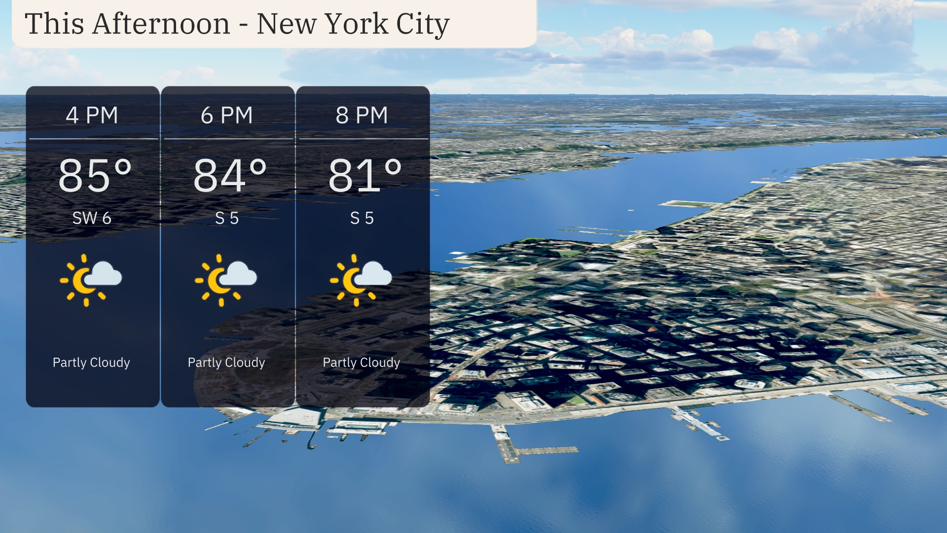
Afternoon temperatures in New York City are reaching up to 85 degrees by 4 PM, with a light southwest wind around 6 miles per hour. By 6 PM, temperatures dip slightly to 84 degrees with winds shifting to the south at 5 miles per hour. Expect partly cloudy skies to persist through the afternoon into 8 PM, where it will be 81 degrees with steady south winds.
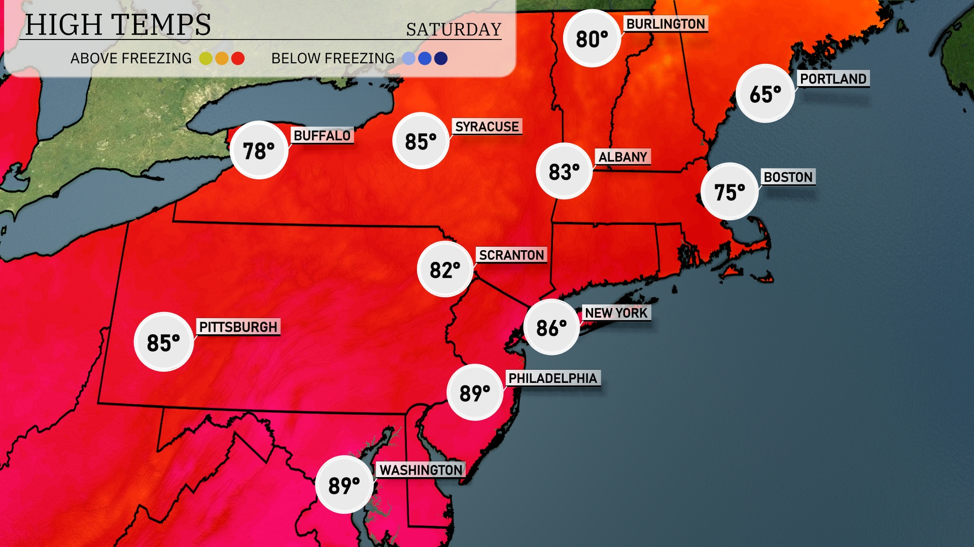
Today’s high temperatures in the Northeast are heating up nicely. New York City will reach 86 degrees, while Philadelphia sizzles at 89. Scranton enjoys a pleasant 82 degrees, and Syracuse is slightly warmer at 85. Boston is cooler at 75 degrees, and Buffalo will see a high of 78. An interesting contrast lies in Portland, where temperatures are only reaching 65 degrees.
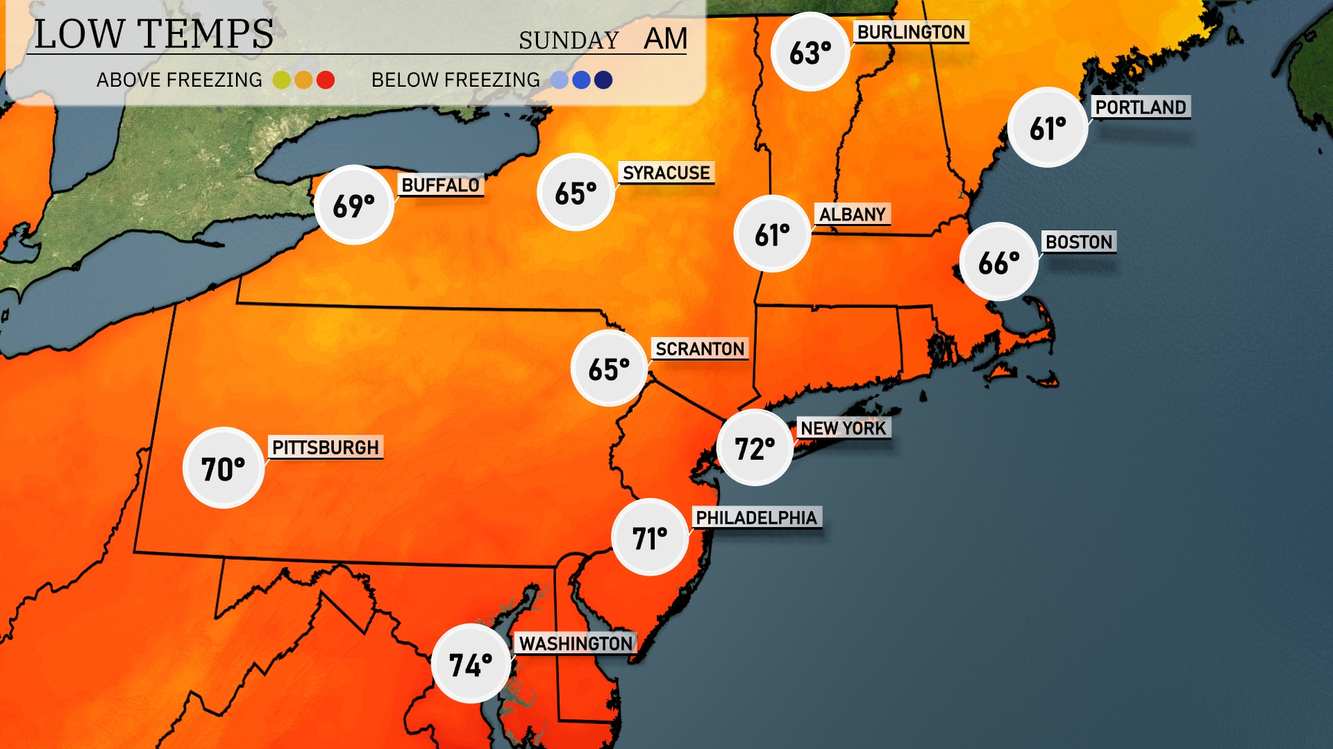
Tonight, expect temperatures to drop significantly in the Northeast. Boston will cool down to 66 degrees, while Albany hits a low of 61. Scranton will see 65 degrees, and New York City is forecasted to drop to 72. Notably, Pittsburgh will experience a mild night at 70 degrees, remaining warmer than many nearby areas.
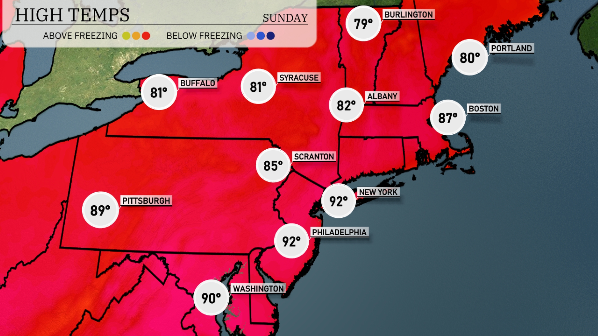
Tomorrow in the Northeast, expect a strong surge of warmth as New York hits a high of 92 degrees. Philadelphia will see similar temperatures, also reaching 92, while Washington warms to 90 degrees. Scranton isn’t far behind with a high of 85, and further north, Buffalo and Syracuse are set for 81 degrees each. Boston will warm up to a balmy 87, making it a notably hot day across the region, with many areas experiencing temperatures significantly above average due to a dominant ridge of high pressure.
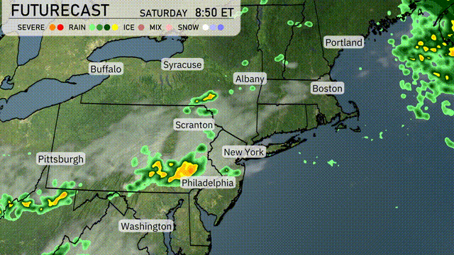
Saturday’s weather in the Northeast starts with showers moving through New York and Philadelphia, with the potential for heavier rain in the afternoon in these areas. Watch for thunderstorms developing late morning to early afternoon from Scranton to Albany as a frontal boundary shifts eastward. Temperatures will range from the mid-70s to low 80s, with the potential for strong gusts accompanying any storms, especially around New York City in the late evening. Coastal cities, including Boston, are likely to see clearing skies by Saturday night, setting the stage for a quieter Sunday.
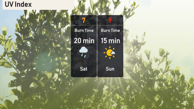
The UV index in New York City will be high at 7 on Saturday, with a potential burn time of around 20 minutes, indicating that sun protection is necessary. On Sunday, expect a very high UV index of 9, where exposure can lead to a burn in just 15 minutes.