‘Weather or Not’: Navigating NYC’s Summer Extremes
By
Amy Freeze
Explore the dynamic shifts from sunny skies to storm fronts in NYC and the Northeast—perfect for planning your summer days.
Partly sunny days and possible thunderstorms—get the latest updates on NYC’s complex weather patterns for a perfect summer week plan.
This week in NYC and the Northeast sees a rollercoaster of temperatures and conditions. From highs of 92 degrees in NYC to thunderstorms affecting plans, our detailed guide helps you navigate the erratic yet typical summer weather. Remember, a UV index ranging from high to very high means sunscreen is your best friend! Looking ahead, a cold front on Sunday might bring some needed relief but watch out for those storm warnings! Stay informed and safe with our in-depth analysis and daily updates.
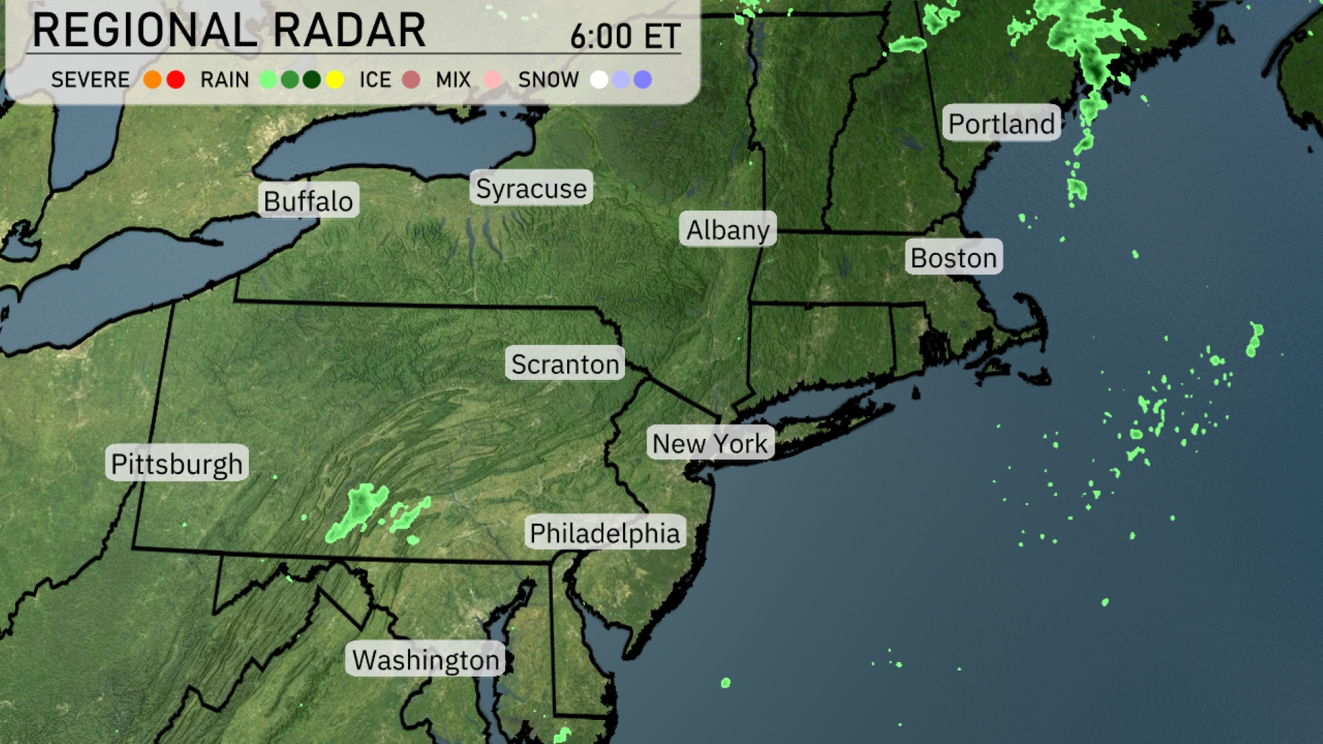
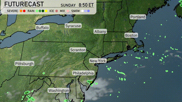
Over the Northeast, scattered light rain showers are visible with the most activity over Portland and into upstate New York including Syracuse. A few showers are skirting areas near Pittsburgh as well. The rest of the region, from Boston down to Washington, D.C., appears dry with patchy clouds dominating the sky. Albany and Scranton are experiencing mostly clear conditions, setting the stage for a calm morning.
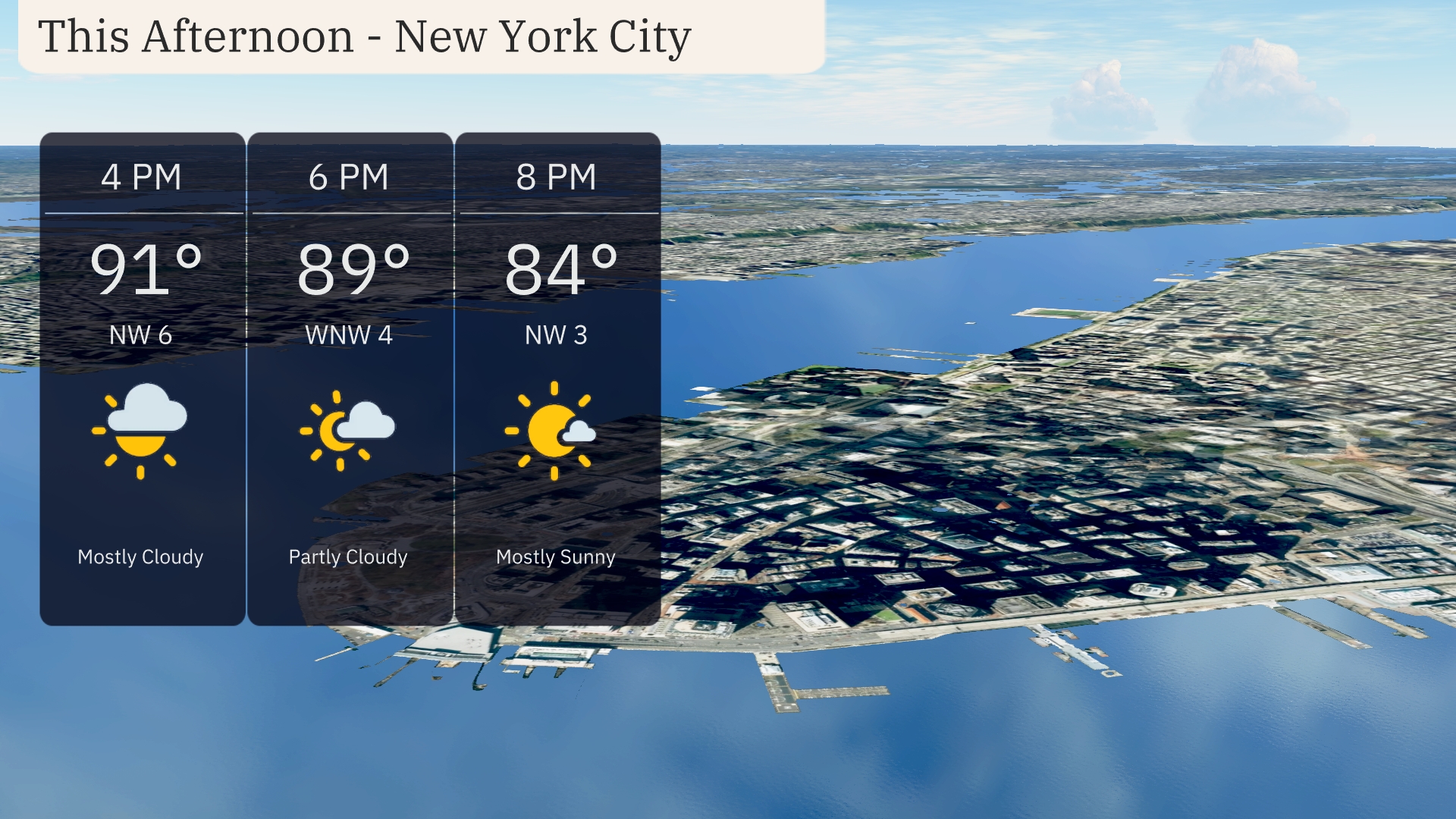
For the afternoon in New York City, temperatures will peak at 91 degrees with mostly cloudy skies. Winds will be from the northwest at 6 mph, providing a slight breeze. By 6 PM, temperatures will ease to 89 degrees with partly cloudy conditions and winds shifting to west-northwest at 4 mph. Expect clearer skies towards 8 PM as it becomes mostly sunny, with temperatures dropping to 84 degrees and northwest winds at 3 mph.
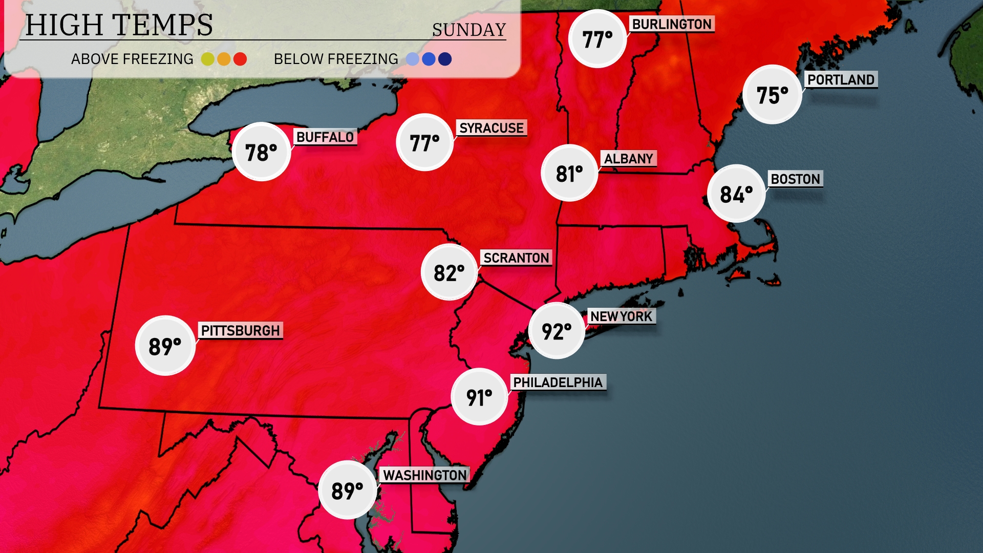
Today’s high temperatures in the Northeast are showcasing some significant variations. New York City sizzles at 92 degrees, while Philadelphia is not far behind at 91. Scranton is a bit cooler with a high of 82, and Syracuse sits at 77. To the north, Albany enjoys a comfortable 81 degrees, whereas Buffalo checks in at 78. Coastal areas like Boston are experiencing a milder day with a high of just 84 degrees.
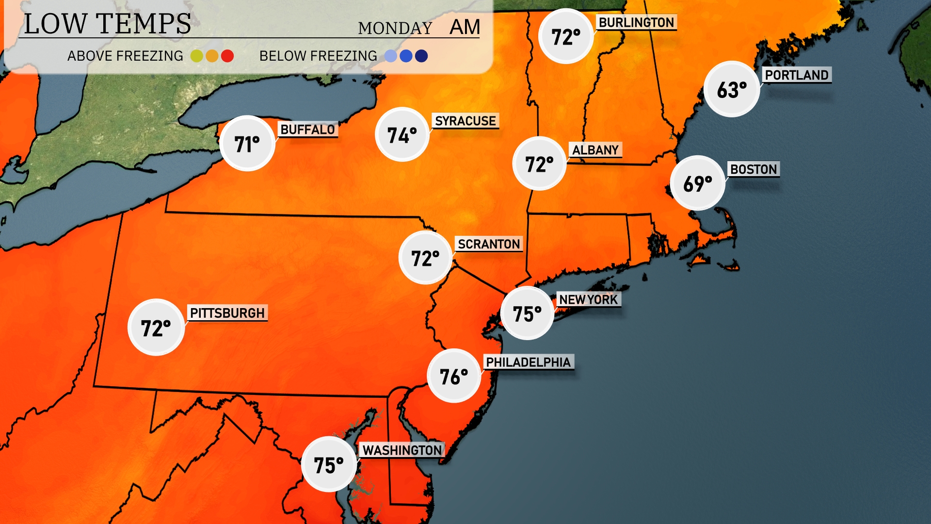
Tonight, temperatures in the Northeast will experience mild lows. New York City will see a low of 75 degrees, while Philadelphia is expected to drop to 76. Boston will cool down to 69 degrees, and Albany will reach 72 degrees. Meanwhile, Buffalo will have a low of 71 degrees, setting the stage for a comfortably warm night across the region.
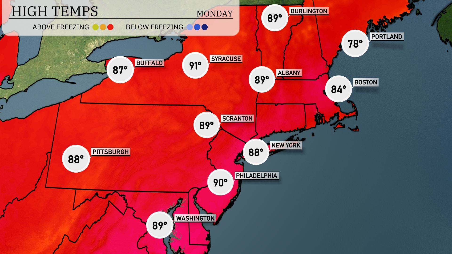
Tomorrow, temperatures in the Northeast will soar, with Philadelphia hitting a scorching 90 degrees. New York won’t be far behind, reaching 88 degrees, while Boston will see a more moderate high of 84 degrees. Cities like Scranton and Syracuse can expect highs of 89 and 91 degrees, respectively, both above the seasonal averages. Pittsburgh will also warm up to 88 degrees, indicating a widespread heat trend across the region. Meanwhile, Portland will remain cooler at 78 degrees, providing some relief from the heat.
A cold front is set to move through the Northeast Sunday evening, impacting areas from Washington, D.C., to Boston. Expect scattered showers and thunderstorms, some of which might bring heavy rainfall and gusty winds, particularly across southern New York and Pennsylvania. As the front passes, cooler air will sweep in, leading to a noticeable drop in temperatures for Monday. Highs tomorrow will range from the upper 60s to mid-70s, providing a refreshing relief. Monitor for localized flooding in areas with heavier rain, and ensure plans are flexible as conditions could change swiftly.
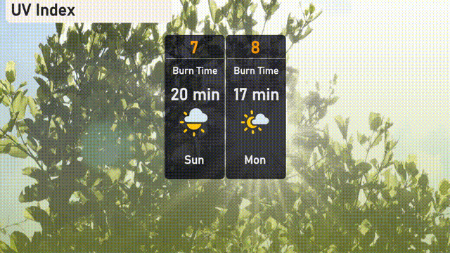
The UV index in New York City will be high today with a value of 7, suggesting a burn time of around 20 minutes in direct sunlight. Monday sees the index climb to 8, reducing the burn time to just 17 minutes. Be sure to apply sunscreen and wear protective clothing to safeguard against sunburn!