Miami and Southeast Weather Update: Cooler Evenings and Heated Days Ahead
By
Amy Freeze
Explore how Miami and the Southeast brace for varied weather patterns this week, from serene evenings to stormy days.
Tonight in Miami will be cloudy with temperatures steady in the low 80s, while the Southeast prepares for a varied weather week. Check out what’s forecasted!
This evening in Miami, temperatures will hold steady, providing calm before the impending weather changes across the Southeast. With parts of the region expecting severe storms and others clear skies, the week promises a mix of conditions. Join us as we delve deeper into the daily specifics and what they mean for your area. Stay weather-aware with updates on potential thunderstorms and cooling trends toward the weekend.
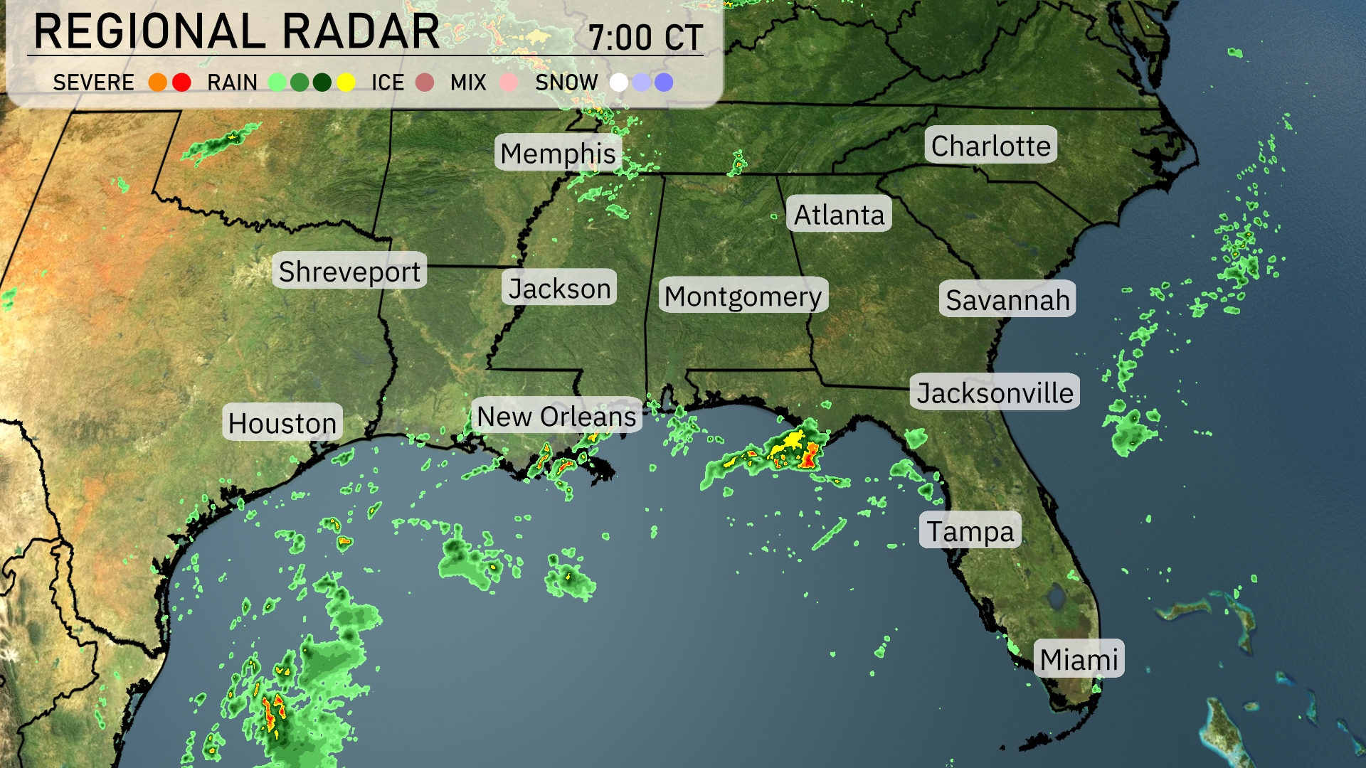
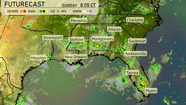
On the Regional Radar, a pocket of severe storms is located just off the coast of Louisiana, moving towards New Orleans. Meanwhile, rain showers are popping up along the Mississippi River near Jackson, shifting eastward. Atlanta is experiencing increasing cloud cover as showers approach from Alabama, while Jacksonville remains under clear skies. Further south, Miami and Tampa are dry, with scattered showers situated over the Gulf of Mexico.
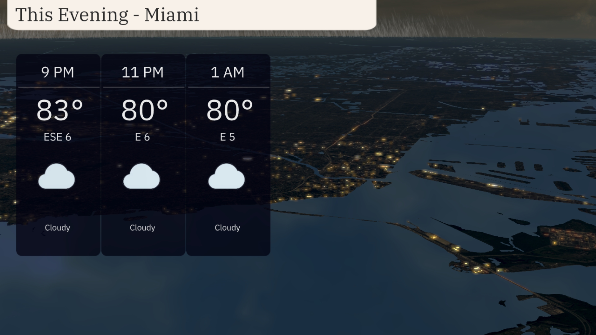
This evening in Miami, temperatures will hold steady in the low 80s, with 83 degrees at 9 PM, dropping slightly to 80 by 11 PM and continuing at 80 degrees through 1 AM. Expect a light easterly wind at 5 to 6 miles per hour. The sky will remain cloudy, providing a quiet and consistent night pattern.
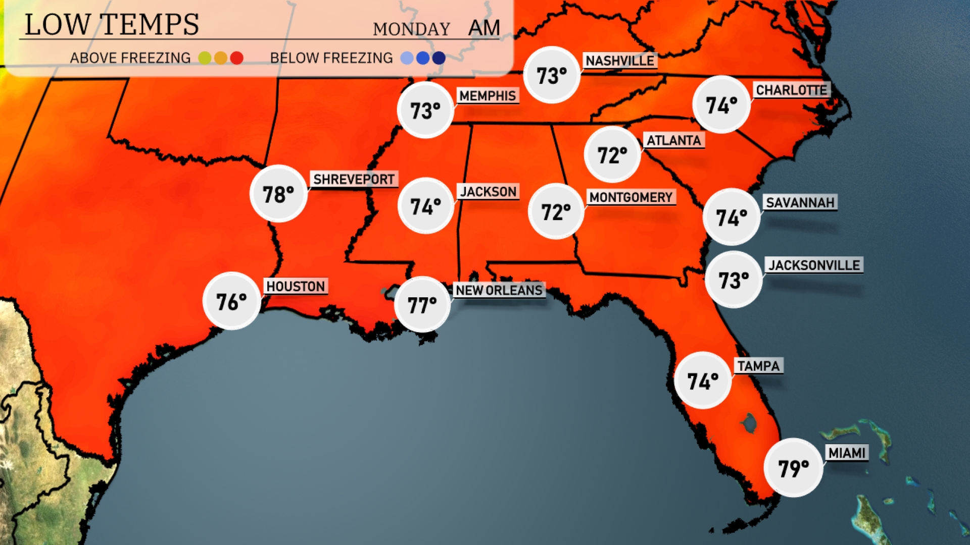
Tonight, Memphis will reach a low of 73 degrees. Nashville cools down to 72, while Jackson will see a low of 74. Atlanta and Montgomery will have similar lows at 72 and 74 degrees respectively. Expect slightly warmer weather in New Orleans with a low of 77 and a mild 73 in Jacksonville.
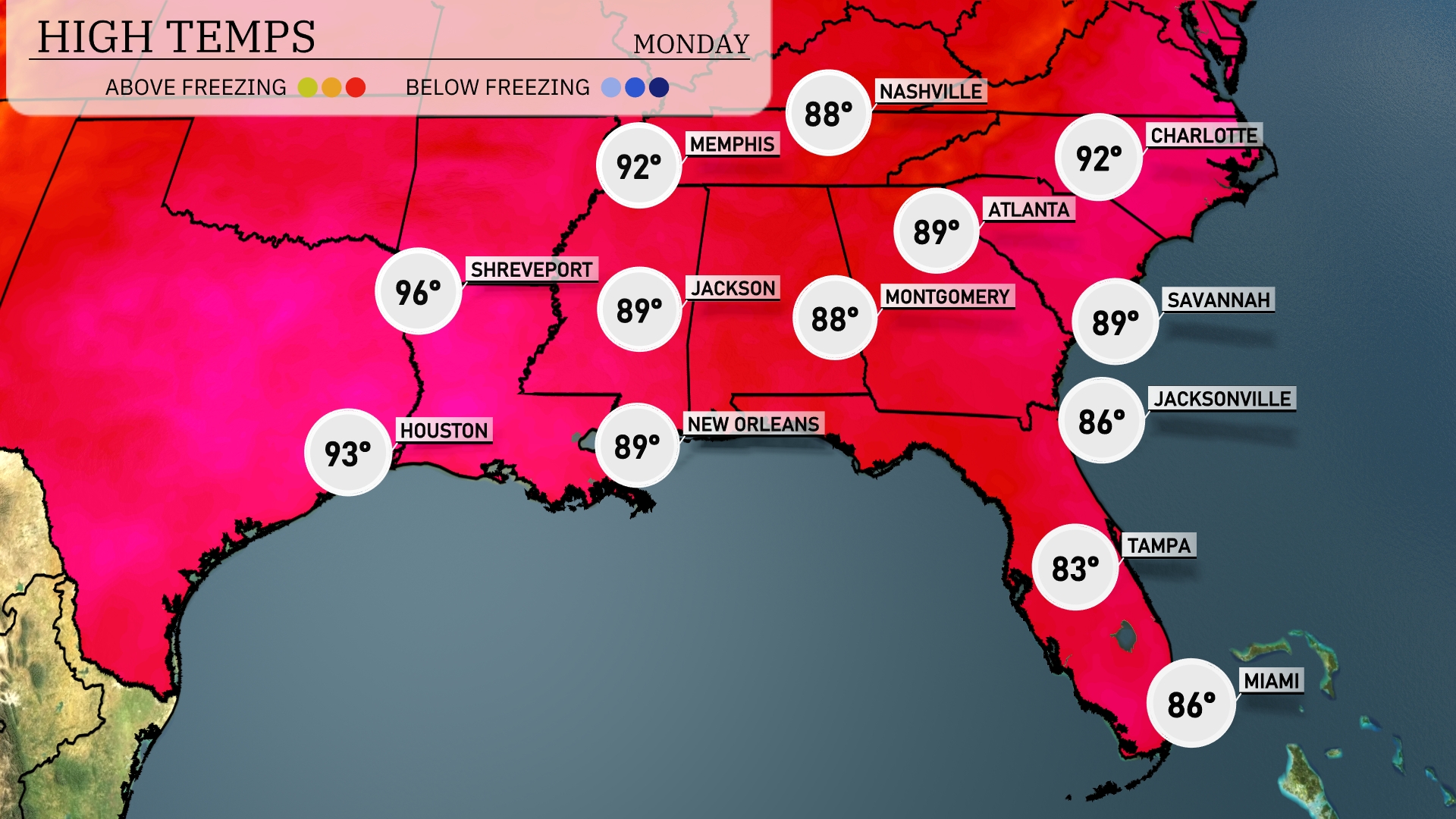
Tomorrow, Houston will reach a hot 93 degrees, while Shreveport sizzles at 96. In New Orleans, temperatures will be pleasant at 89 degrees. Meanwhile, Atlanta and Montgomery also see highs around 89. Florida’s coast will be warm, with Jacksonville hitting 86, and Tampa slightly lower at 83 degrees. Overall, much of the Southeast is experiencing above-average temperatures, driven by a dominant high-pressure system.
A cold front moves into the Southeast tonight, bringing thunderstorms with possible heavy rain. Expect these storms to sweep from Jackson through Montgomery and into Atlanta by tomorrow morning, with a chance of severe weather and heavy downpours. Rainfall may exceed an inch in some areas, presenting a risk of localized flooding, particularly in urban areas. As the front progresses, thunderstorms are anticipated to extend from Jacksonville up to Charlotte. Clearing is expected by Wednesday, ushering in cooler temperatures and drier conditions heading into the weekend.
Today in Miami, the UV index will be 8, which means sun protection is essential with a burn time of approximately 17 minutes. As for Monday, the index spikes to 11, bringing intense sun exposure risks, with just 11 minutes to burn. Remember to apply sunscreen and wear hats when outdoors!
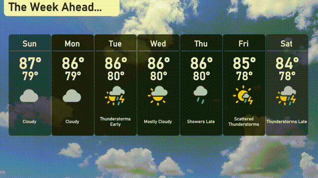
Sunday: Cloudy with a high of 87 degrees and a low of 79 degrees.
Monday: Expect more clouds with temperatures reaching a high of 86 degrees and a low of 79 degrees.
Tuesday: Look out for early thunderstorms. The high will be 86 degrees and the low around 80 degrees.
Wednesday: Mostly cloudy, with temperatures holding steady at a high of 86 degrees and a low of 80 degrees.
Thursday: Showers are expected late in the day. The high will remain at 86 degrees, cooling to 80 overnight.
Friday: Scattered thunderstorms anticipated with a high of 85 degrees and a low of 78 degrees.
Saturday: Thunderstorms develop late, with a daytime high of 84 degrees and a nighttime low of 78 degrees.
Hope that helps! Stay safe!