Midwest Mosaic: A Detailed Look at This Week’s Weather Patterns
By
Amy Freeze
Explore the swings from stormy to serene in our latest Midwest weather forecast, featuring temperature trends and storm updates.
This evening, Chicago is gearing up for scattered thunderstorms with changes across the Midwest. Learn more about what the weather holds for every day of the week in our detailed guide.
Tonight, Chicago braces for scattered storms, while the Midwest experiences a gamut of weather patterns from Kansas City’s sizzle to Indianapolis’s cool breezes. With a detailed daily breakdown, our latest post ensures you’re fully prepped for any weather event from today’s mild showers to the weekend’s heatwave and subsequent thunderstorms.
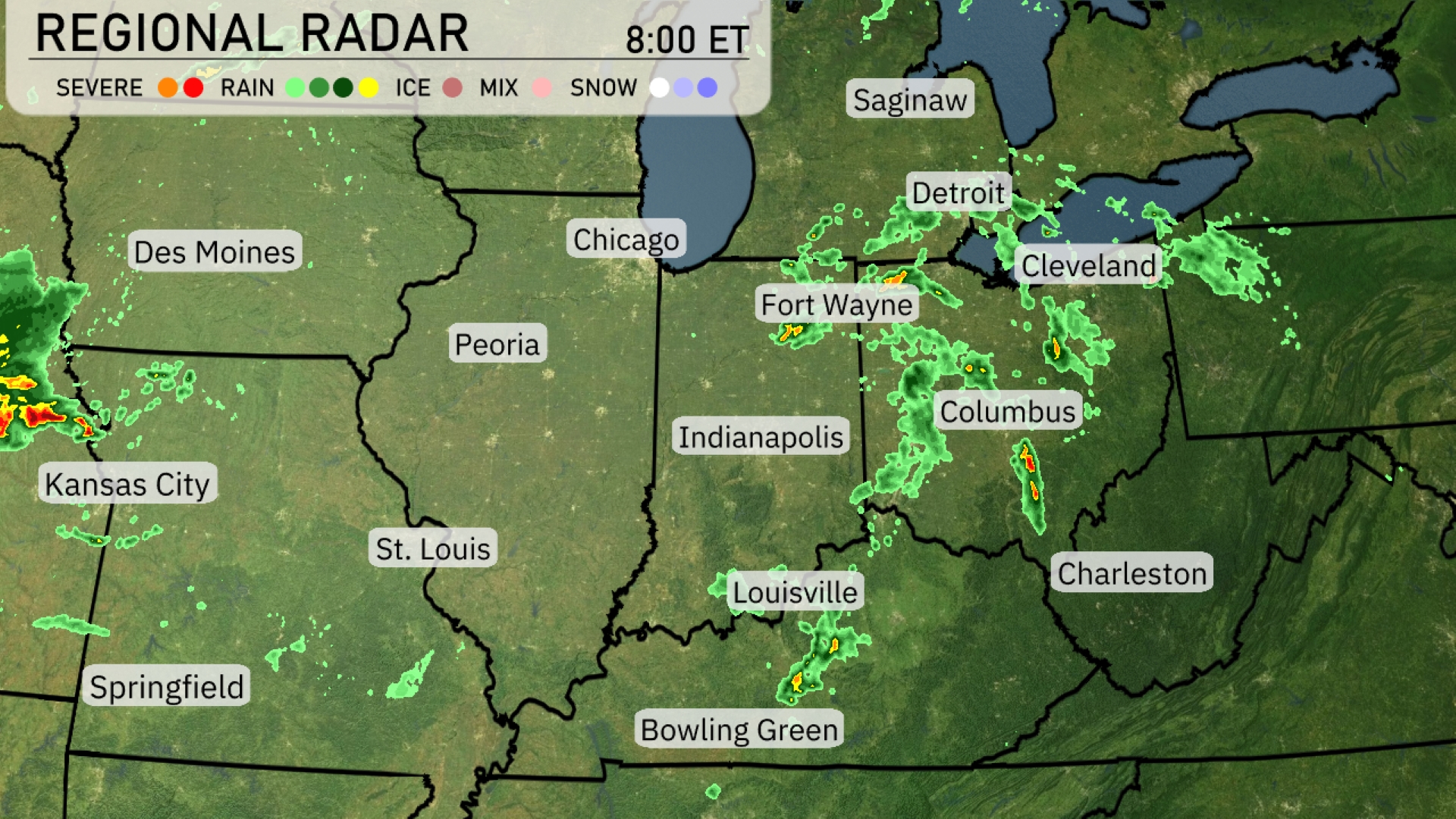
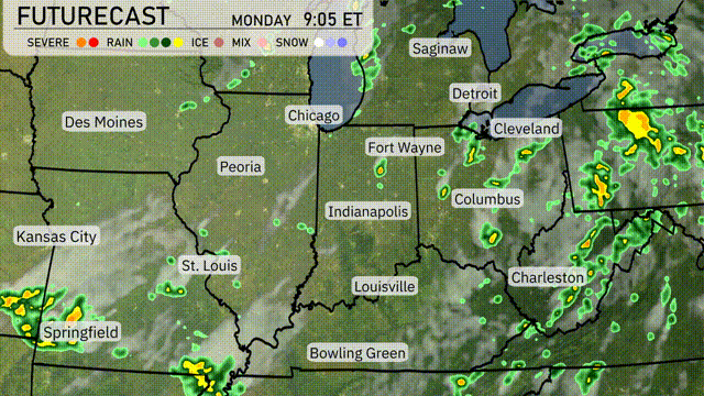
A strong line of storms is developing over Kansas City, moving east toward St. Louis. Detroit and Cleveland are experiencing scattered showers with more rain tracking northeast. Fort Wayne and Columbus are also seeing steady rain, which is expected to persist through the evening. Indianapolis and Bowling Green are watching for isolated storms, while conditions clear out a bit further south near Charleston.
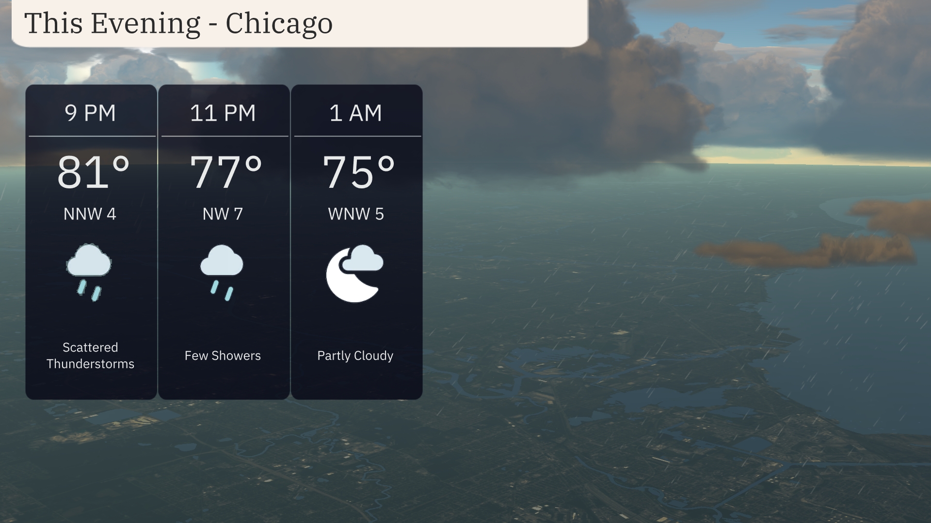
For this evening in Chicago, expect scattered thunderstorms starting with temperatures around 81 degrees at 9 PM and a north-northwest wind at 4 mph. By 11 PM, the temperature dips to 77 degrees with a few showers possible, as winds increase to 7 mph. As the night progresses to 1 AM, look for partly cloudy skies with temperatures settling at 75 degrees and winds from the west-northwest at 5 mph.
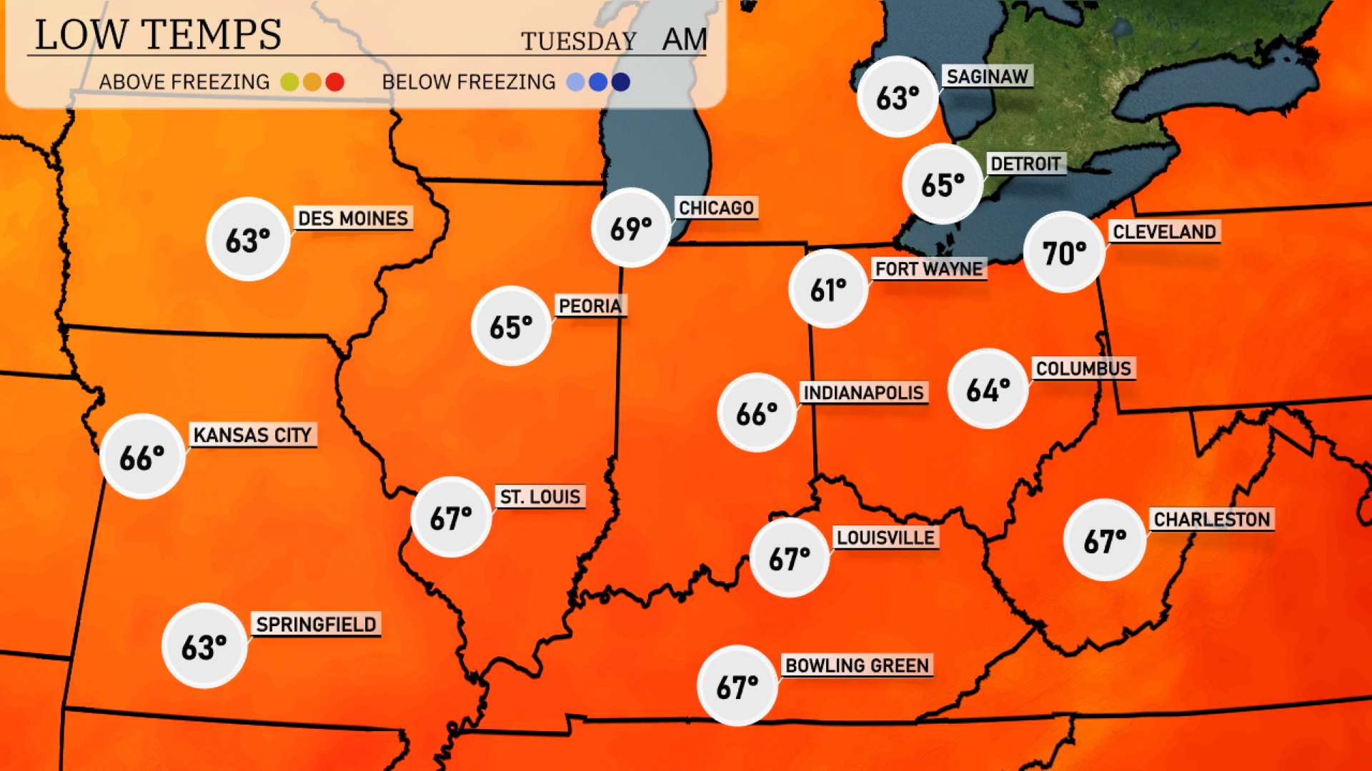
Tonight, low temperatures in the Midwest will vary, with Chicago expected to drop to 63 degrees. Indianapolis will see a cooler 61 degrees, while Fort Wayne will register at 60 degrees. St. Louis will be mild at 67 degrees, and Kansas City will maintain a low of 66 degrees.
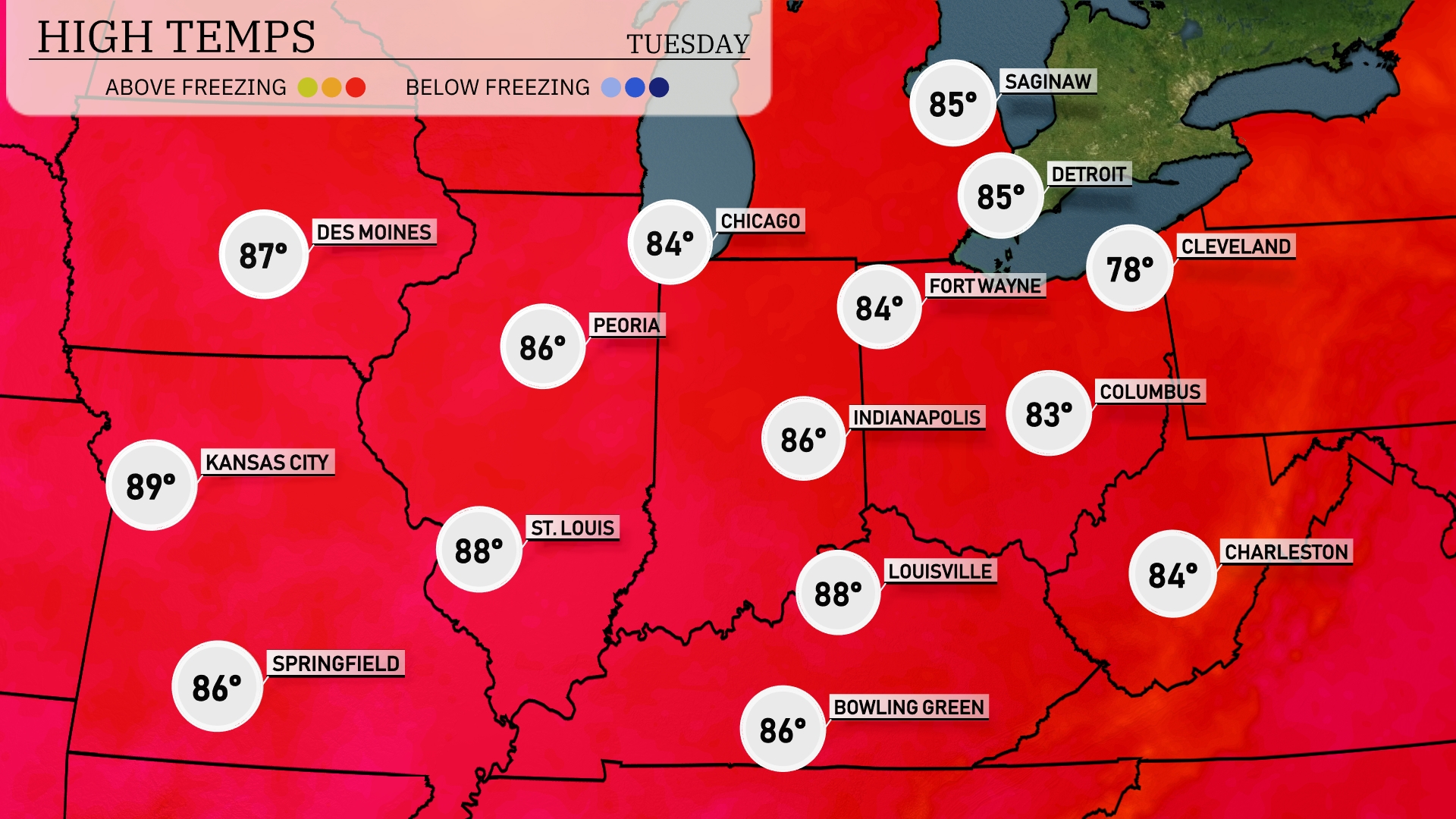
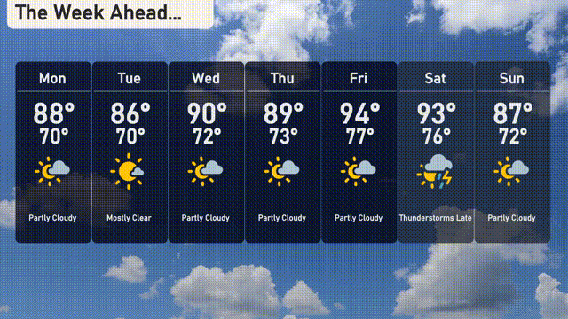
Tomorrow, Kansas City will sizzle with a high of 89 degrees, while St. Louis is expected to reach 88. Indianapolis and Louisville both look to see warm temperatures of 86 degrees. Further north, Chicago will enjoy a pleasant high of 84 degrees.
A potent storm system is set to shift into the Midwest tomorrow with a strong cold front sweeping across the region. Expect thunderstorms to develop in eastern Illinois and Indiana, lasting through Tuesday evening, likely producing heavy rainfall and strong winds. The system will move eastward into Ohio by Tuesday night, bringing scattered showers to Cleveland and Cincinnati. Temperatures will drop by 5-10 degrees following the frontal passage, providing cooler conditions for Wednesday.
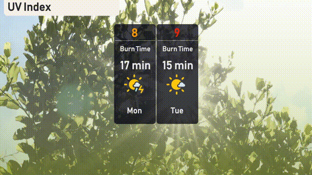
The UV index in Chicago will be very high on Monday with a level of 8, leading to a burn time of just 17 minutes. On Tuesday, it becomes extreme with a UV index of 9, reducing the burn time to 15 minutes.
Tuesday: Mostly clear skies with a high of 86 degrees and a low of 70 degrees.
Wednesday: Temperatures rise to a warm 90 degrees in the afternoon, with a low of 72 degrees.
Thursday: Partly cloudy conditions continue, reaching a high of 89 degrees and dipping to 73 degrees overnight.
Friday: Things heat up further with partly sunny skies and temperatures peaking at 94 degrees, cooling down to 77 degrees at night.
Saturday: Expect thunderstorms later in the day, with a high of 93 degrees and a low around 76 degrees.
Sunday: Partly cloudy skies return, with a high of 87 degrees and a low of 72 degrees.
Monday: Another day of partly cloudy conditions, temperatures peak at 88 degrees and drop to 70 degrees overnight.