Weather Whiplash: Chicago’s Weekly Weather Dance from Sun to Storms
By
Amy Freeze
Explore how Chicago’s weather shifts from clear, sunny skies to thunderstorms in our comprehensive weekly forecast.
This week in Chicago, experience everything from sunny afternoons with gentle breezes to unexpected thunderstorms. Dive into our article for daily weather details to plan your week.
As Chicago enjoys partly sunny conditions this Monday, the weather story turns intriguing with the arrival of a strong cold front on Tuesday. The Midwest is set for a dynamic weather week, from high temperatures reaching the 90s to thunderstorms rolling in by mid-week, potentially disrupting commutes. Stay up-to-date with our daily and insightful 7-day forecast on our blog post at https://amyfreeze.ai.
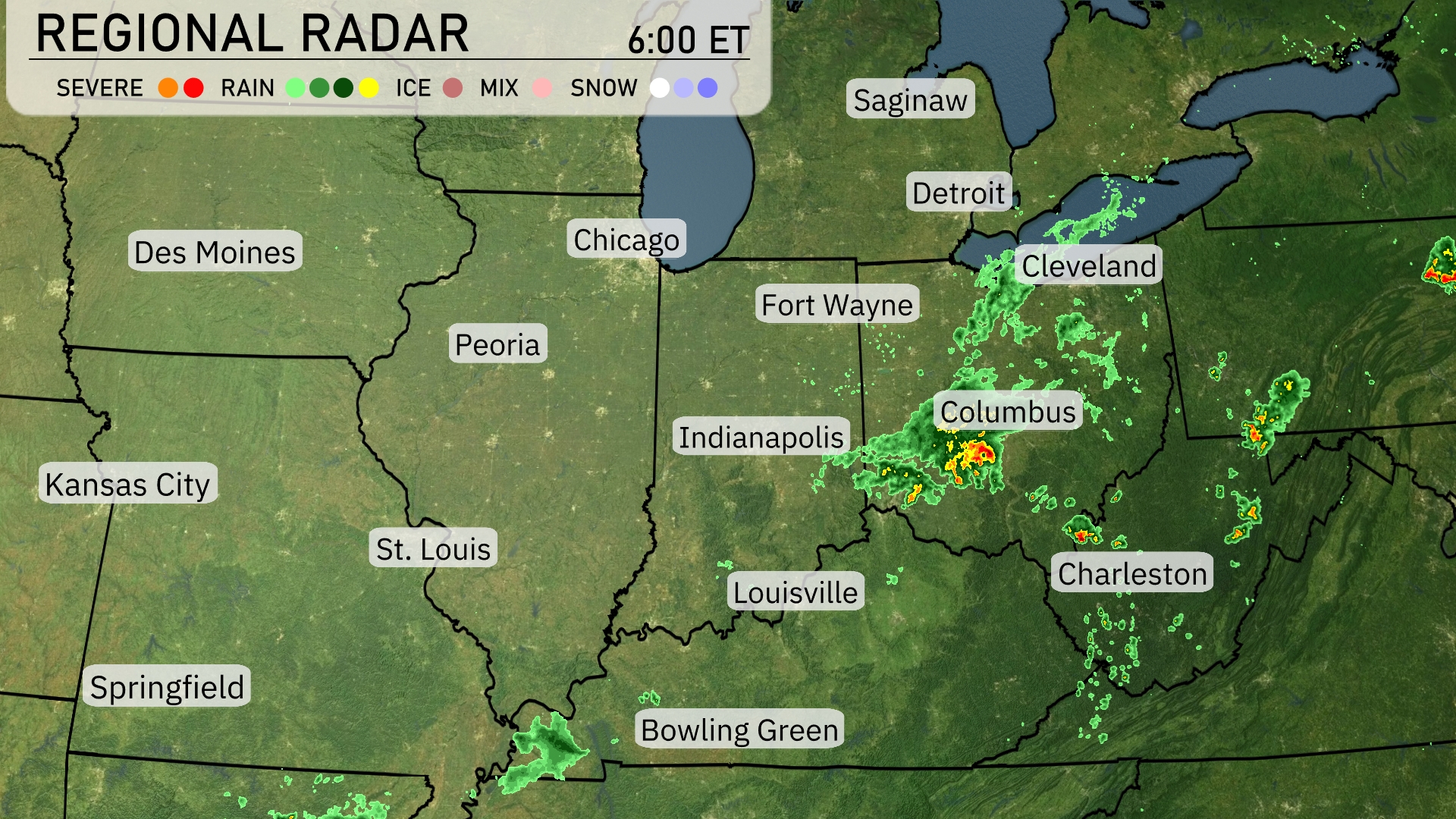
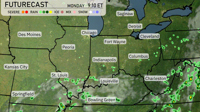
Over the Midwest, we see a significant band of precipitation stretching from Detroit down through Indianapolis and into Louisville. Columbus is experiencing intense storms, showcasing the most severe weather in the region. Cleveland and Fort Wayne are under moderate rain showers, while the skies over Chicago and St. Louis remain clear. In the southern part, approaching Bowling Green, scattered rain is also making its presence known.
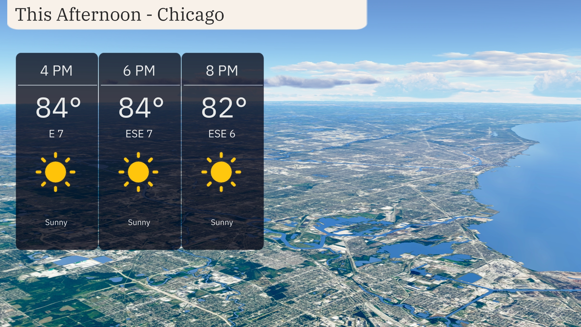
This afternoon in Chicago, enjoy clear, sunny skies with temperatures steady at 84 degrees. Winds will be light from the east-southeast at 7 miles per hour, providing a gentle breeze. As we head into the evening, temperatures will slightly decrease to 82 degrees by 8 PM, keeping the atmosphere warm and pleasant.
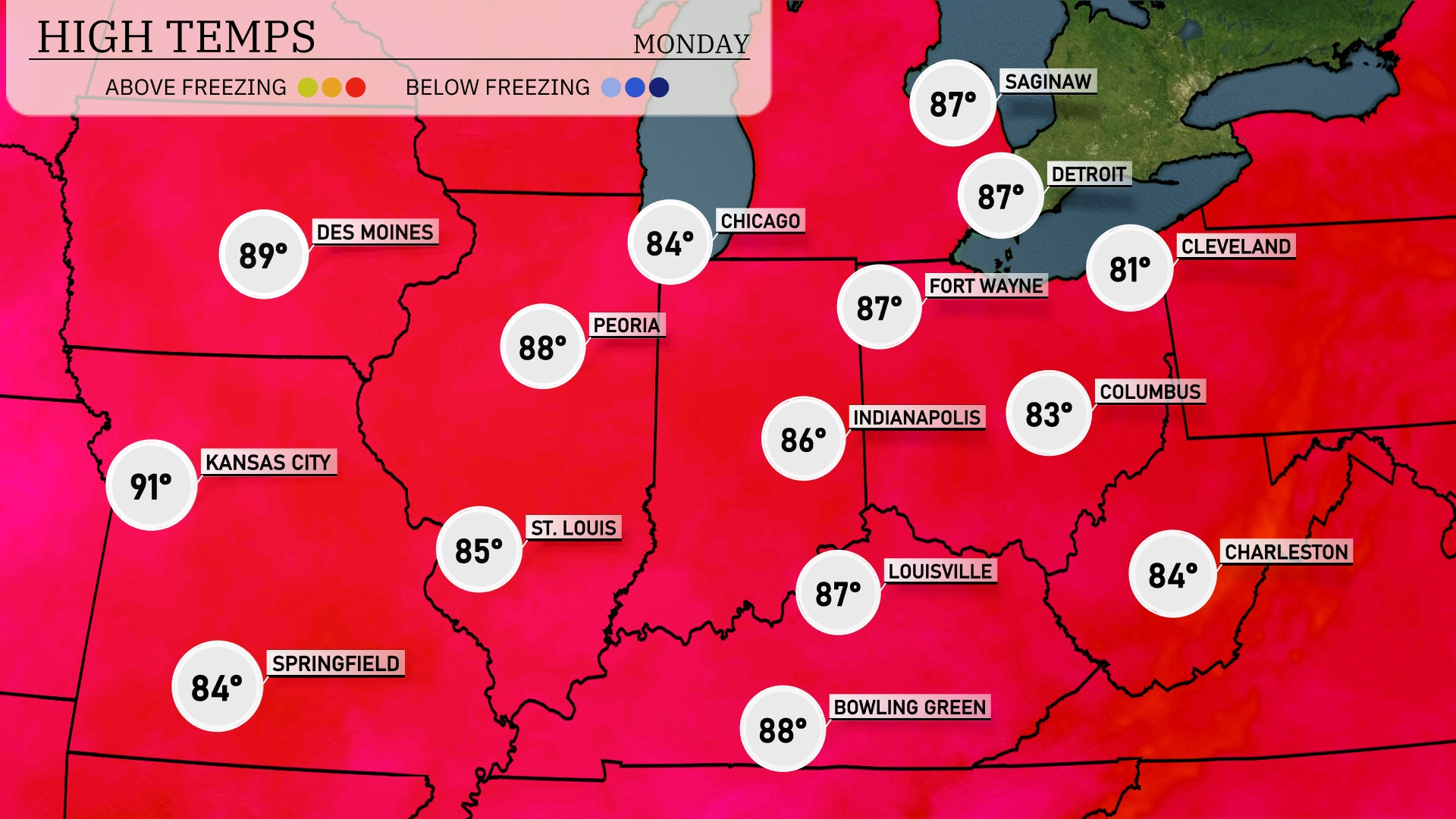
This afternoon, we’re seeing some warm temperatures across the Midwest. Kansas City is soaring to a high of 91 degrees, while St. Louis will be a bit cooler at 85. In Indiana, Indianapolis checks in with a high of 86, and Peoria, Illinois, will reach 88 degrees. Moving to the north, Chicago is experiencing a pleasant 84, while fort Wayne is slightly warmer at 87. A noticeable contrast is seen in Cleveland with a high of just 81, making it one of the cooler spots today in the region.
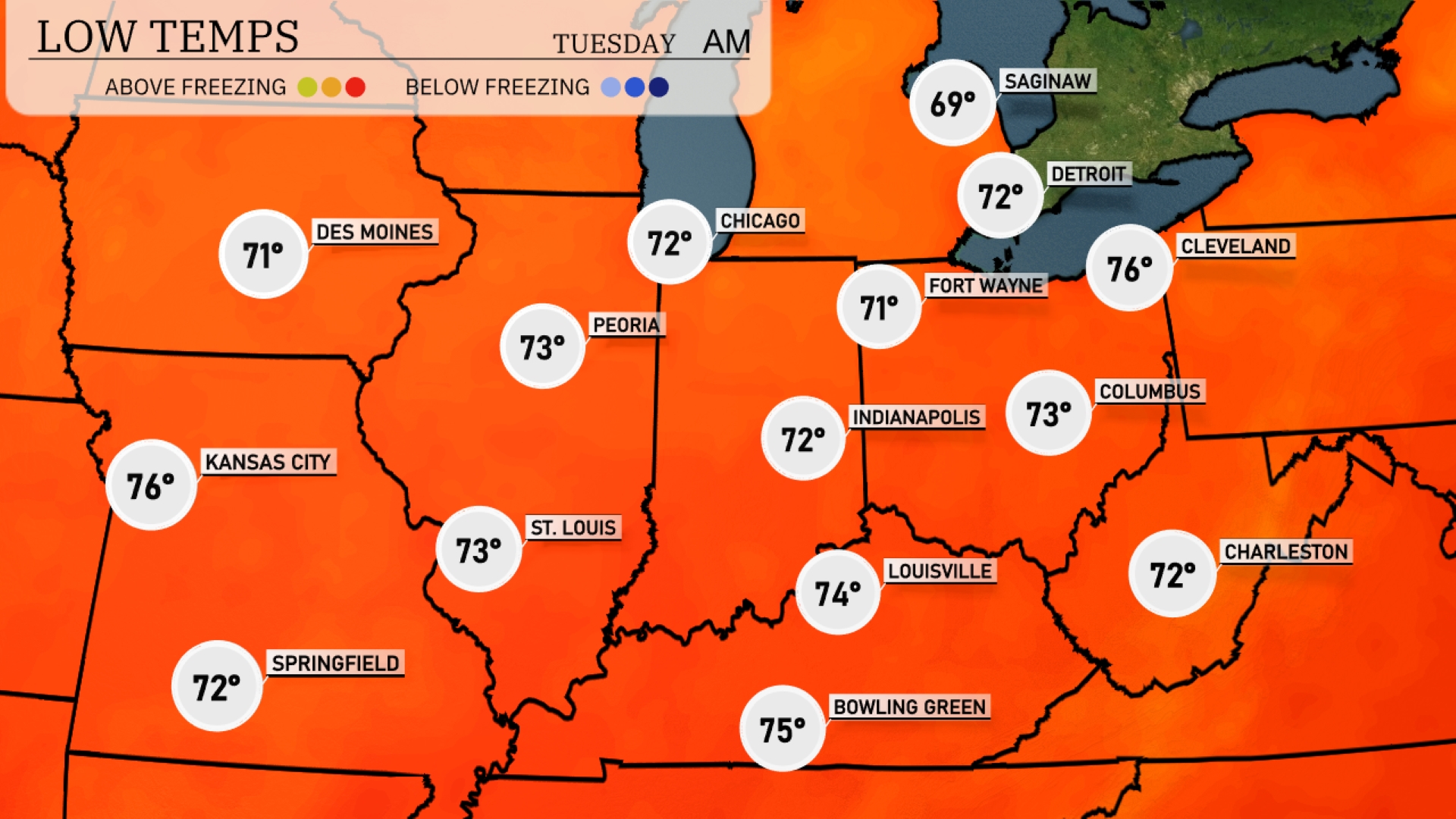
Tonight, low temperatures in the Midwest will hover around 71 degrees in Des Moines and Fort Wayne. Chicago will see a low of 72, while Indianapolis and Peoria will also drop to 72. Expect slightly cooler conditions in Detroit at 69 degrees. Overall, a mild night is on the way for the region, with no significant cold air patterns developing.
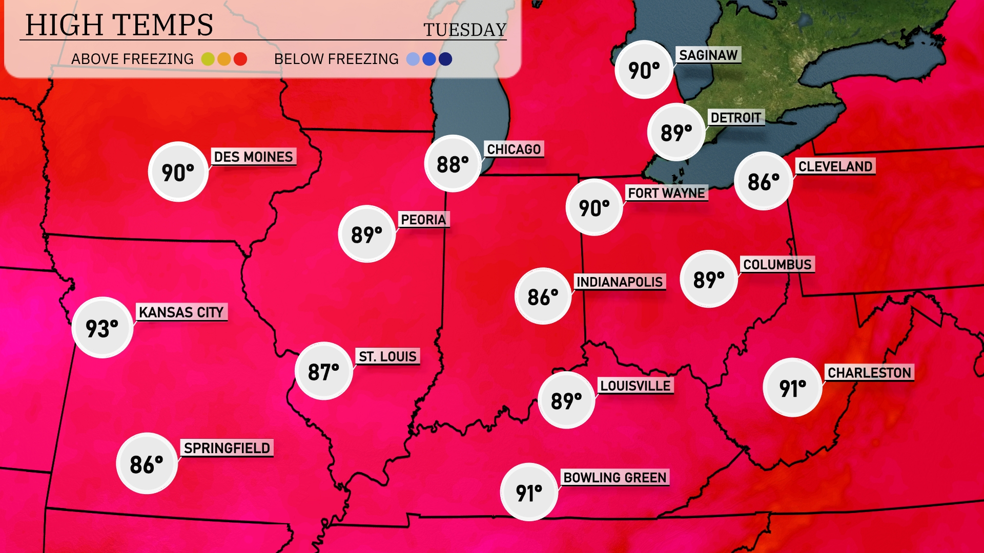
Tomorrow, high temperatures in the Midwest will soar with Kansas City reaching a sizzling 93 degrees, significantly above average for this time of year. St. Louis will also be warm at 87 degrees, while Peoria will see a high of 89. The heat continues with Chicago hitting near 88 degrees and Indianapolis warming up to 86. This warm spell is influenced by a persistent ridge of high pressure, keeping conditions dry and cloudless across the region.
A strong cold front is projected to sweep across the Midwest tomorrow, bringing a wave of thunderstorms and a risk of severe weather. Expect significant temperature drops as this front passes, with highs decreasing by nearly 10 degrees. In cities like Chicago and Indianapolis, brace for potential heavy rainfall and gusty winds that could disrupt evening commutes. The heaviest precipitation and storm activity are likely centered in the areas stretching from St. Louis to Cincinnati, where localized flooding could become an issue. As the front moves eastward by late afternoon, clearer and cooler conditions should follow into Wednesday.
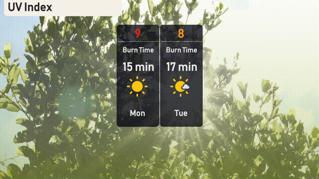
The UV index in Chicago will be high on Monday with a value of 9, and you can expect a quick burn time of 15 minutes in direct sunlight. By Tuesday, the index slightly decreases to 8, extending the burn time to about 17 minutes. Make sure to protect your skin with sunscreen and shade during peak afternoon hours!