Miami’s Mixed Weather Pattern: From Sunscreen to Umbrellas!
By
Amy Freeze
Explore the dynamic weather changes in Miami this week—from sunny skies to threatening thunderstorms. Get the full weekly forecast and tips on how to stay protected from the sun's harsh rays.
This week in Miami brings a mix of sun and storms. Find daily highs, lows, and storm warnings to stay prepared.
Welcome to your detailed Miami forecast this week! As mornings start partly cloudy, we anticipate a shift to stormier conditions by afternoon. With a UV index soaring to extreme on Tuesday, protective measures are a must. Expect variability across Southeast, with thunderstorms and potential hail by midweek. End your week with clearer skies by Sunday. Stay updated, stay safe!
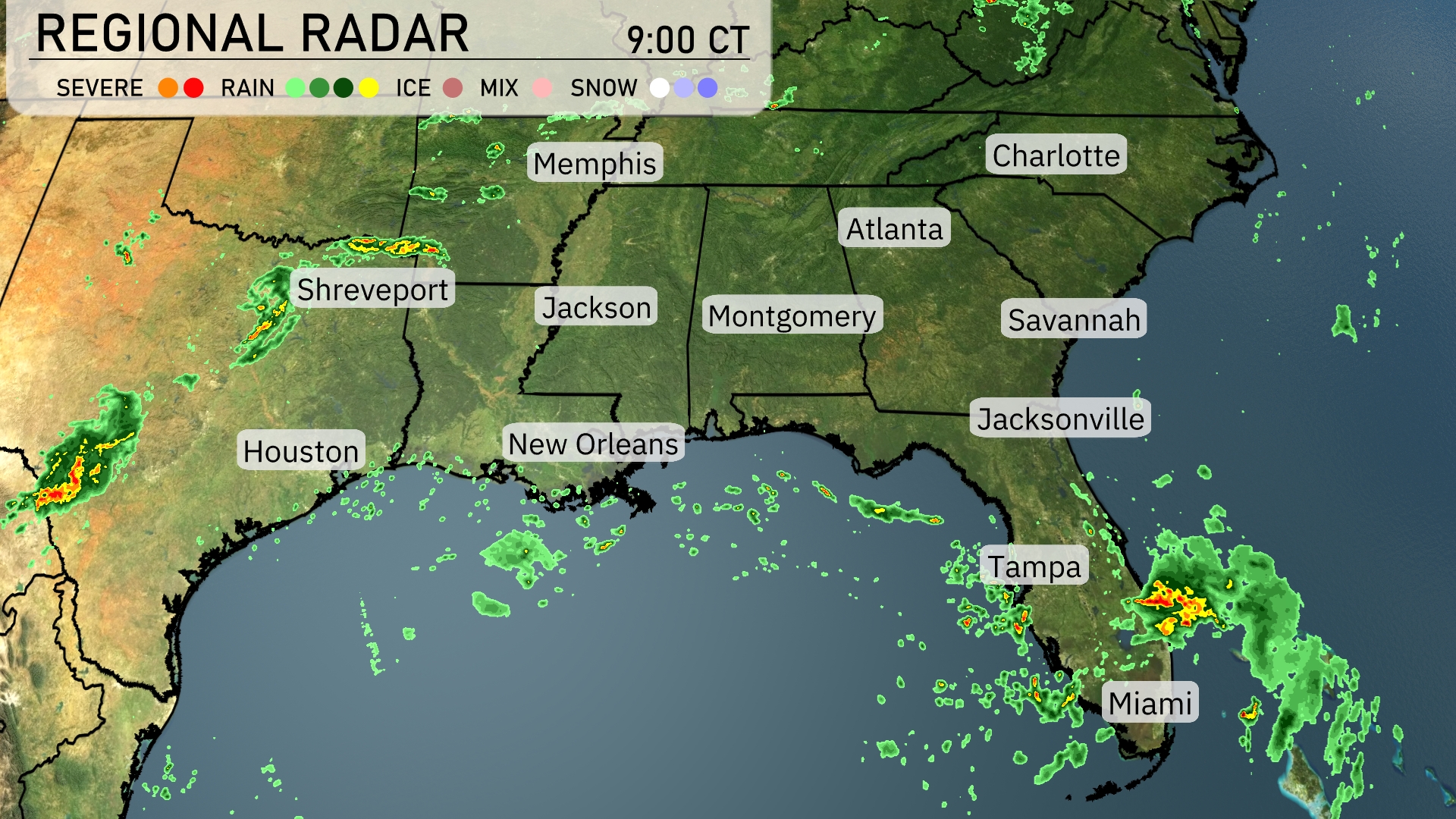
On the Regional Radar, a cluster of thunderstorms is developing near Shreveport and heading eastward. Showers and storms are spreading across parts of Mississippi, while Montgomery and areas around Atlanta remain under cloudy skies with scattered rain showers. In Florida, Miami and Jacksonville are experiencing scattered thunderstorms, contributing to stormy weather. Meanwhile, the Gulf Coast near Houston and New Orleans sees isolated showers, bringing some wet conditions to the region.
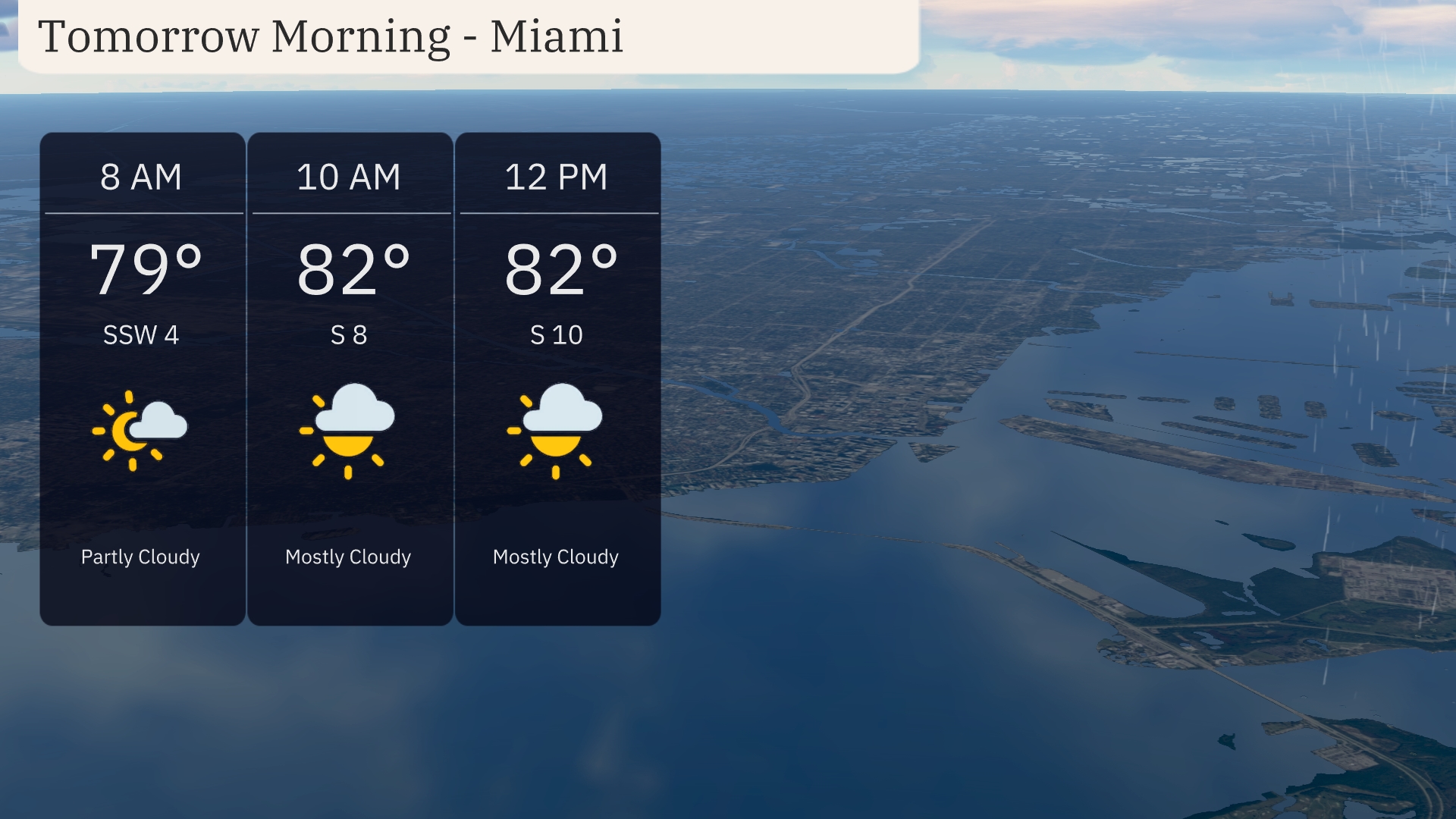
In Miami, tomorrow morning kicks off with partly cloudy skies at 8 AM and a warm temperature of 79 degrees. By 10 AM, skies transition to mostly cloudy with temperatures rising to 82 degrees, accompanied by a south breeze at 8 mph. Through the late morning, clouds remain predominant as temperatures hold steady at 82 degrees with a light south wind at 10 mph.
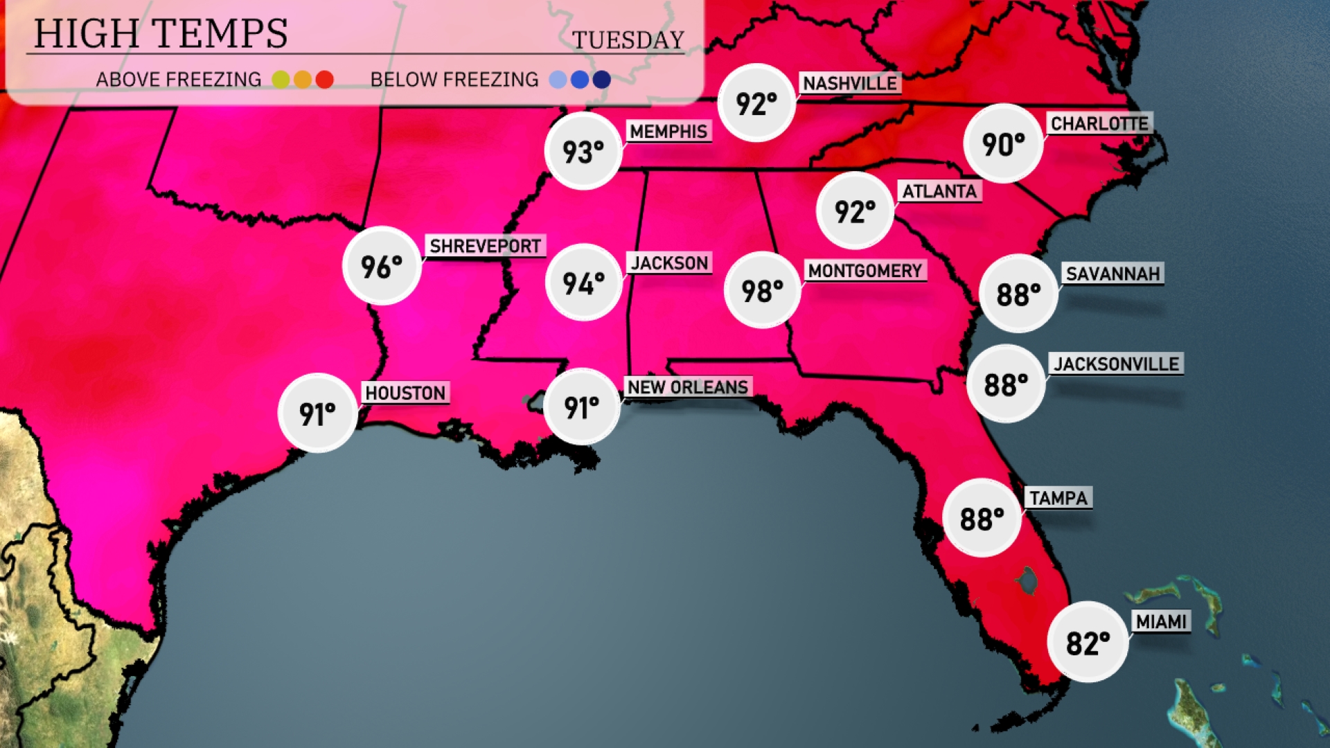
Tomorrow, Montgomery will be sizzling with a high of 98 degrees, marking a notable above-average day for the area. Atlanta is also heating up, expecting highs of 92 degrees. In New Orleans, temperatures will reach 91 degrees, while Jackson sees a slightly warmer day at 94 degrees. Further east, both Jacksonville and Tampa are set for highs around 88 degrees. Meanwhile, Memphis will experience a pleasant 93 degrees, contributing to a warm trend across the Southeast.
A cold front is sweeping across the Southeast starting in Shreveport, reaching Atlanta by late Tuesday, bringing with it a wave of thunderstorms and potential severe weather, especially from Jackson to Montgomery. Expect heavy downpours, gusty winds, and isolated hail as the front advances. Rainfall totals could exceed 1-2 inches, increasing flood risk in urban areas. Behind the front, drier and slightly cooler conditions will follow, with clearing skies by Wednesday afternoon. Temperatures will range from the mid-70s to mid-80s across the region.
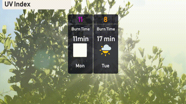
Today in Miami, the UV index will be extreme at 11, with a burn time in as little as 11 minutes. For your Tuesday, a still high UV index of 8 indicates a burn time of approximately 17 minutes. Make sure to wear sunscreen and protective clothing to stay safe!
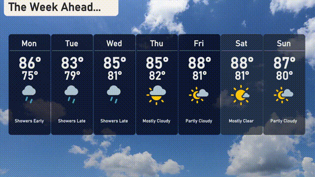
For Miami, here’s your 7-day forecast:
Monday: Showers early with a high of 86 degrees and a low of 75 degrees.
Tuesday: Cooling slightly to a high of 83 degrees with showers expected late in the day, the low will be around 79 degrees.
Wednesday: More showers developing late, with a daytime high of 85 degrees and a low of 81 degrees.
Thursday: Mostly cloudy with chances of rain and temperatures reaching a high of 85 degrees, dipping to 82 degrees at night.
Friday: Enjoy partly cloudy skies with a warm high of 88 degrees and a low of 81 degrees.
Saturday: Mostly clear weather expected, with highs peaking at 88 degrees and overnight lows near 81 degrees.
Sunday: Ending the week with partly cloudy skies and a high around 87 degrees, cooling to 80 degrees at night.
Stay safe and enjoy your week!