Navigating Through Austin’s Skies: Sun, Storms, and Everything In Between
By
Amy Freeze
This week in Austin brings a mix of partly cloudy, sunny, and stormy weather. Read the full daily breakdown and prepare for everything the skies have in store!
Austin’s week features a variety of weather patterns, from pleasant sunny days to approaching storms. Get prepped for shifts from cloudy mornings to sunny afternoons and potential severe weather alerts!
Starting off cloudy in Austin with a gentle breeze, temperatures will rise throughout the week, reaching mid 90s. Prepare for potentially severe storms travelling from Dallas to Corpus Christi. Safety tips: monitor local updates and carry sun protection due to high UV levels.
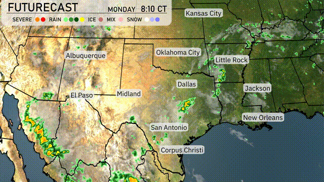
Numerous strong storms are taking shape from Dallas stretching southwest towards San Antonio, bringing high winds and heavy rain. The showers have cleared Oklahoma City but are heading eastward towards Little Rock with some intensity. Meanwhile, clear skies dominate over the plains from El Paso to Midland, promising a dry spell. Light rain flurries trail near Corpus Christi while more scattered showers tail off the coast near New Orleans.
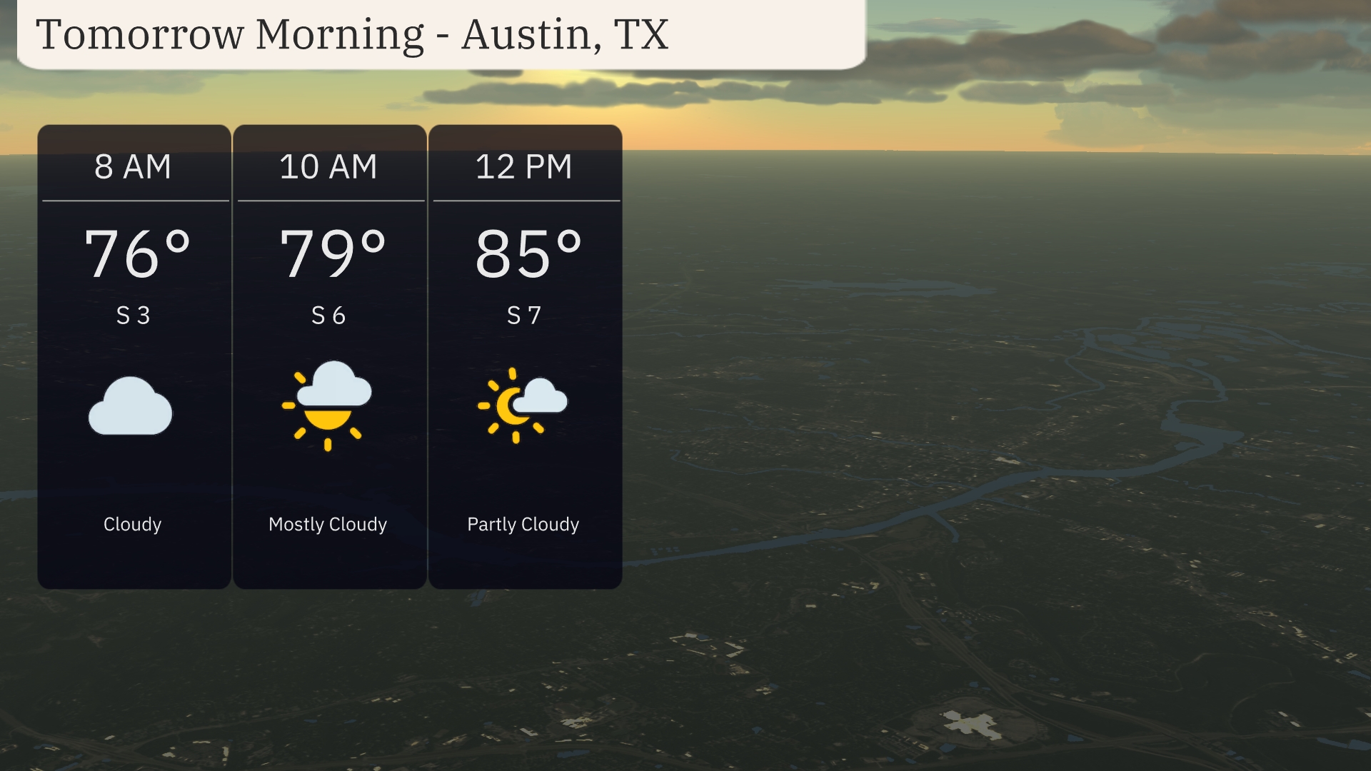
In Austin, tomorrow morning starts off cloudy with temperatures at 76 degrees by 8 AM. By 10 AM, it warms up to 79 degrees with a mostly cloudy sky. A subtle breeze from the south around 6-7 miles per hour provides a gentle airflow. As we approach midday, conditions shift to partly cloudy with the temperature reaching 85 degrees.
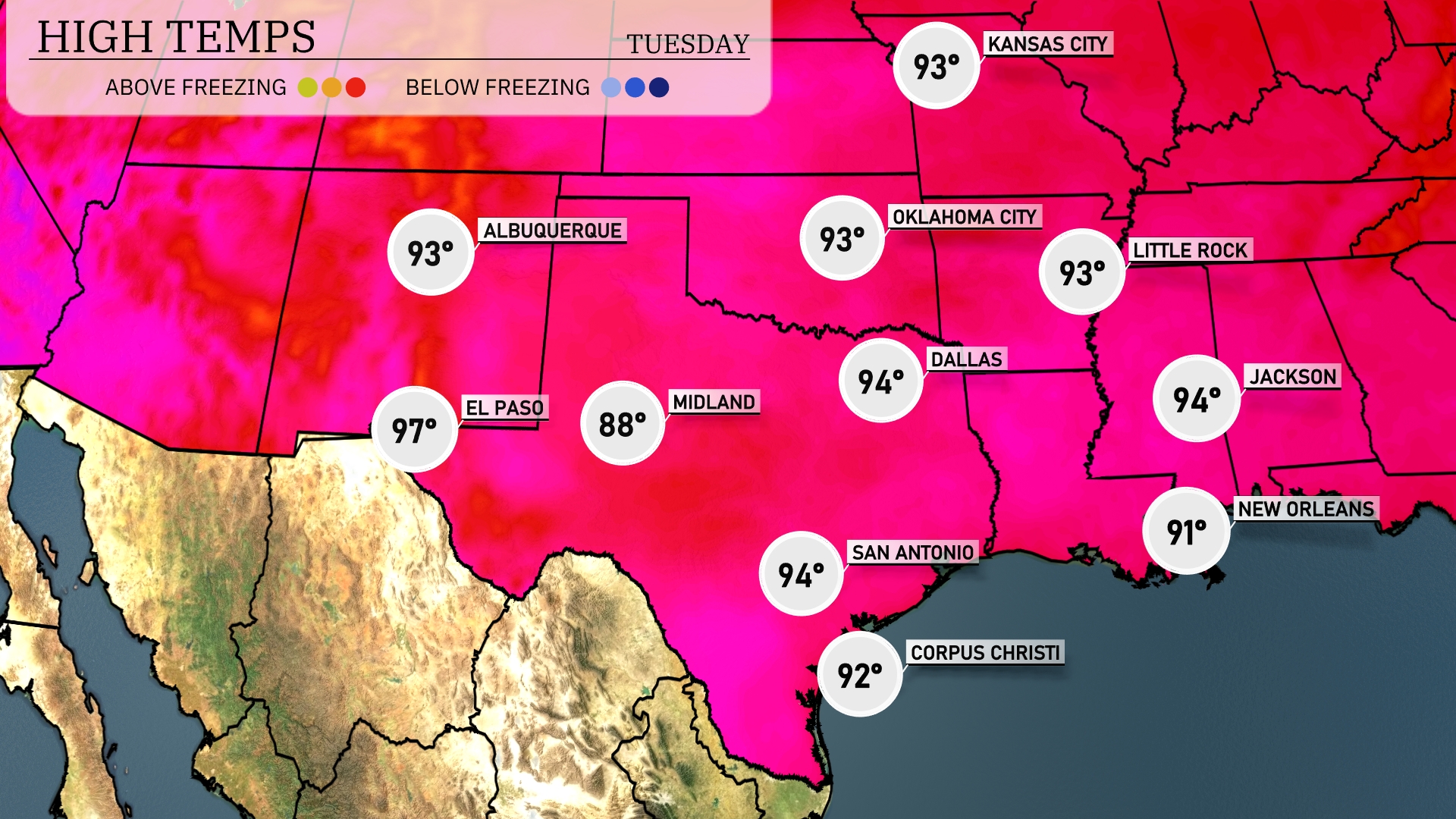
Tomorrow in the Southern Plains, El Paso will see a sizzling high of 97 degrees. Midland warms up to 88, while Dallas reaches a comfortable 94. San Antonio and Little Rock will also experience warm temperatures, each hitting 94. New Orleans lags slightly behind with a high of 91 degrees. Overall, expect above-average temperatures across the region, indicating a strong ridge of high pressure influencing the warm weather.
The Southern Plains will experience a dynamic weather pattern tomorrow, with widespread showers from Dallas to Corpus Christi, offering much-needed moisture relief. Oklahoma City should brace for stronger storms, as a cold front approaches, creating conditions ripe for severe weather, particularly in the southeast portions. Be on the lookout for potential severe weather alerts through Wednesday night as this unstable air mass advances. The region may see heavy rain and strong winds, contributing to challenging travel conditions. Meanwhile, areas around Little Rock and Jackson could experience scattered thunderstorms as the front progresses eastward.
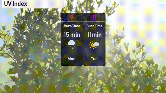
The UV index in Austin peaks at a very high level of 11 on Tuesday, with an expected burn time of just 11 minutes. On Monday, the UV index drops slightly to 9, with a burn time of 15 minutes but cloud cover from expected storms might reduce UV exposure. Remember to use sunscreen, hats, and protective clothing to safeguard against the sun!
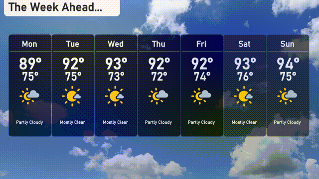
For the 7 day forecast in Austin:
Monday: Partly cloudy with a high of 89 degrees, cooling to a low of 75 degrees at night.
Tuesday: Mostly clear conditions with a high reaching 92 degrees and a low of 75 degrees.
Wednesday: Expect mostly clear skies and a warm day with the temperature peaking at 93 degrees, dipping to 73 degrees overnight.
Thursday: Partly cloudy with highs around 92 degrees, and the low dropping to 72 degrees.
Friday: Mostly sunny day with temperatures peaking at 92 degrees and cooling to 74 degrees by nightfall.
Saturday: Mostly clear skies will continue, with a warm high of 93 degrees and a low of 76 degrees.
Sunday: Partly cloudy and a touch warmer, expect highs around 94 degrees and nighttime lows of 75 degrees.
Enjoy the sunshine in the coming week!