Weather Watch: Evening Update on Miami and Southeast’s Brewing Storms
By
Amy Freeze
Get the latest insights on the partly cloudy skies in Miami, the development of showers from New Orleans to Atlanta, and a tropical storm moving near Tampa. Stay updated with the detailed evening weather forecast.
Explore the latest weather trends and warnings for Miami and the Southeast. From tropical disturbances to sweeping rains, here’s what you need to know to plan your week ahead.
This evening in Miami, expect mostly cloudy skies with a steady temperature of 82 degrees. Showers are developing from New Orleans to Mobile, while a tropical storm near Tampa moves northeast towards Jacksonville. Forecast highs range from 88 degrees in Savannah to a scorching 94 degrees in Jackson. A cold front will introduce thunderstorms and potential severe weather across the region mid-week. With high UV indices, remember to wear sunscreen and stay informed with our full 7-day outlook for Miami.
Showers are developing near New Orleans and stretching toward Mobile, with some rain reaching Montgomery and spreading eastward to Atlanta. Farther south, a well-defined tropical storm is swirling just off the coast of Tampa, moving slightly northeastward towards Jacksonville, bringing rain and breezy conditions along the Florida Peninsula. Patches of heavy rain are present around Houston and the surrounding Gulf Coast areas, enhancing the risk of localized flooding. On the northern edge, clouds are infiltrating Memphis, leading to a calm yet cloudy morning.
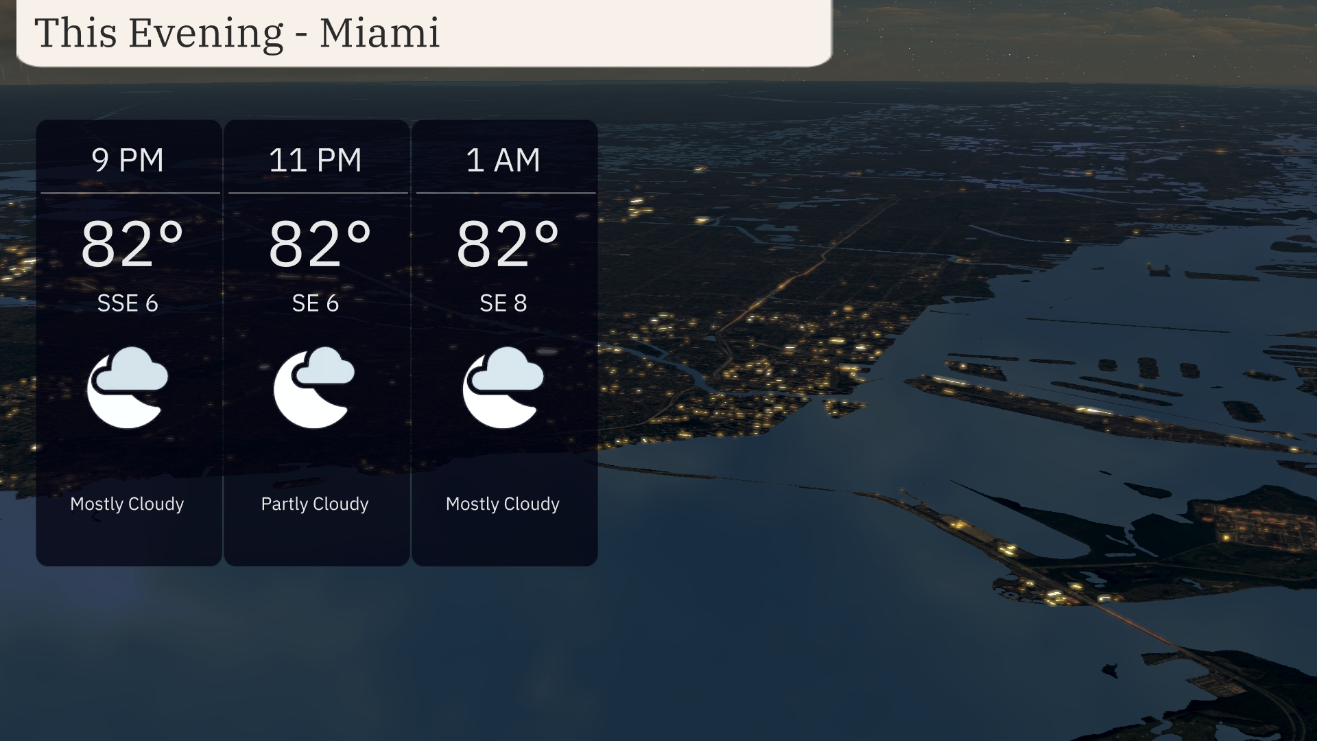
For this evening in Miami, the weather is mostly cloudy with temperatures holding steady at 82 degrees. Winds will be blowing from the south-southeast at 6 to 8 miles per hour. Expect partly cloudy skies at 11 PM, reverting back to mostly cloudy by 1 AM. The evening pattern remains warm and firm with consistent cloud cover.
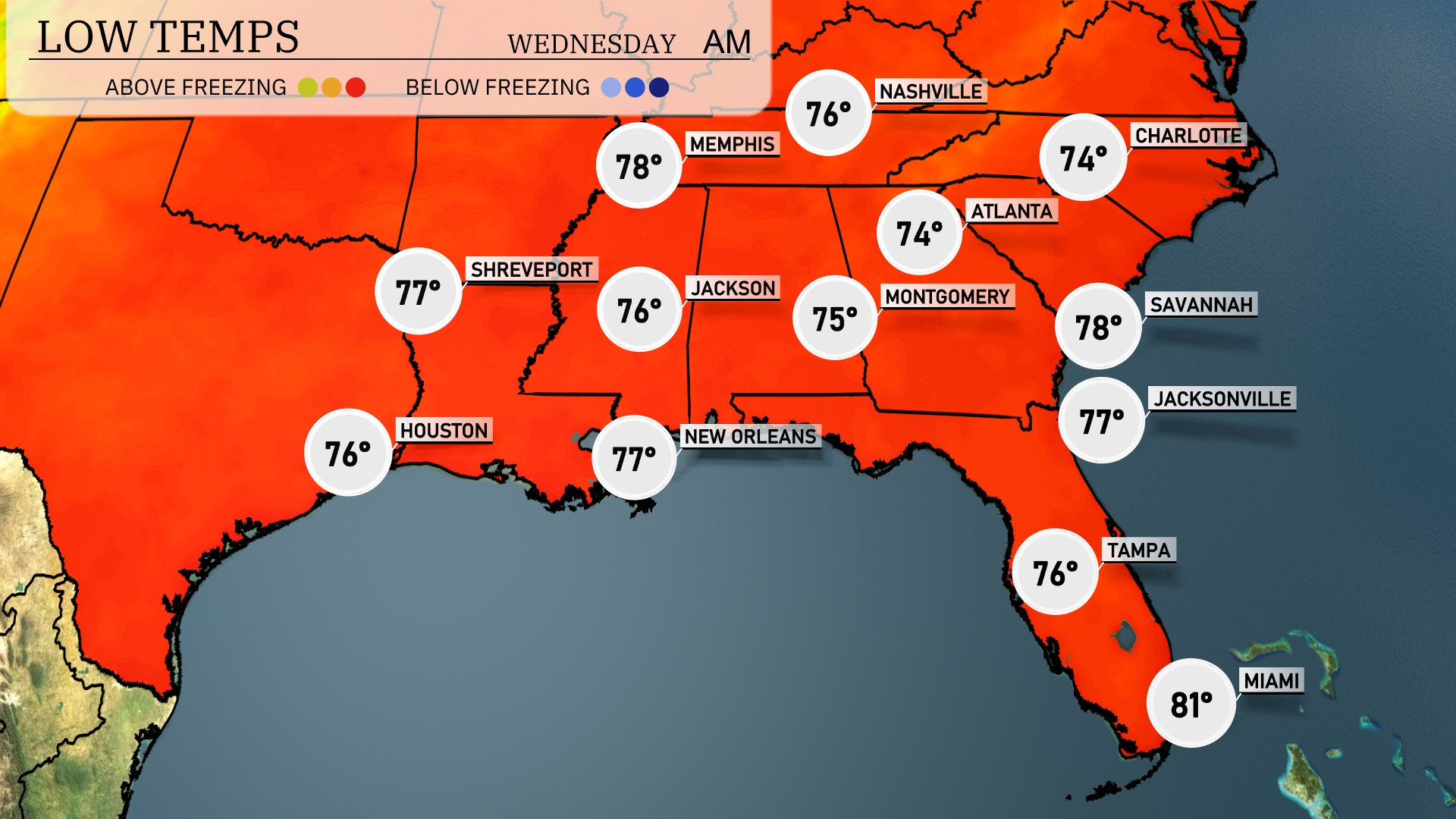
Tonight, expect lows around 76 degrees in Houston and 77 in New Orleans. Memphis will dip to 78 degrees, while Jackson is forecasted to cool down to 76. Montgomery will see a low of 75 degrees, with Atlanta slightly lower at 74. In the coastal cities, Jacksonville will rest at 77, while Tampa remains warmer at 76.
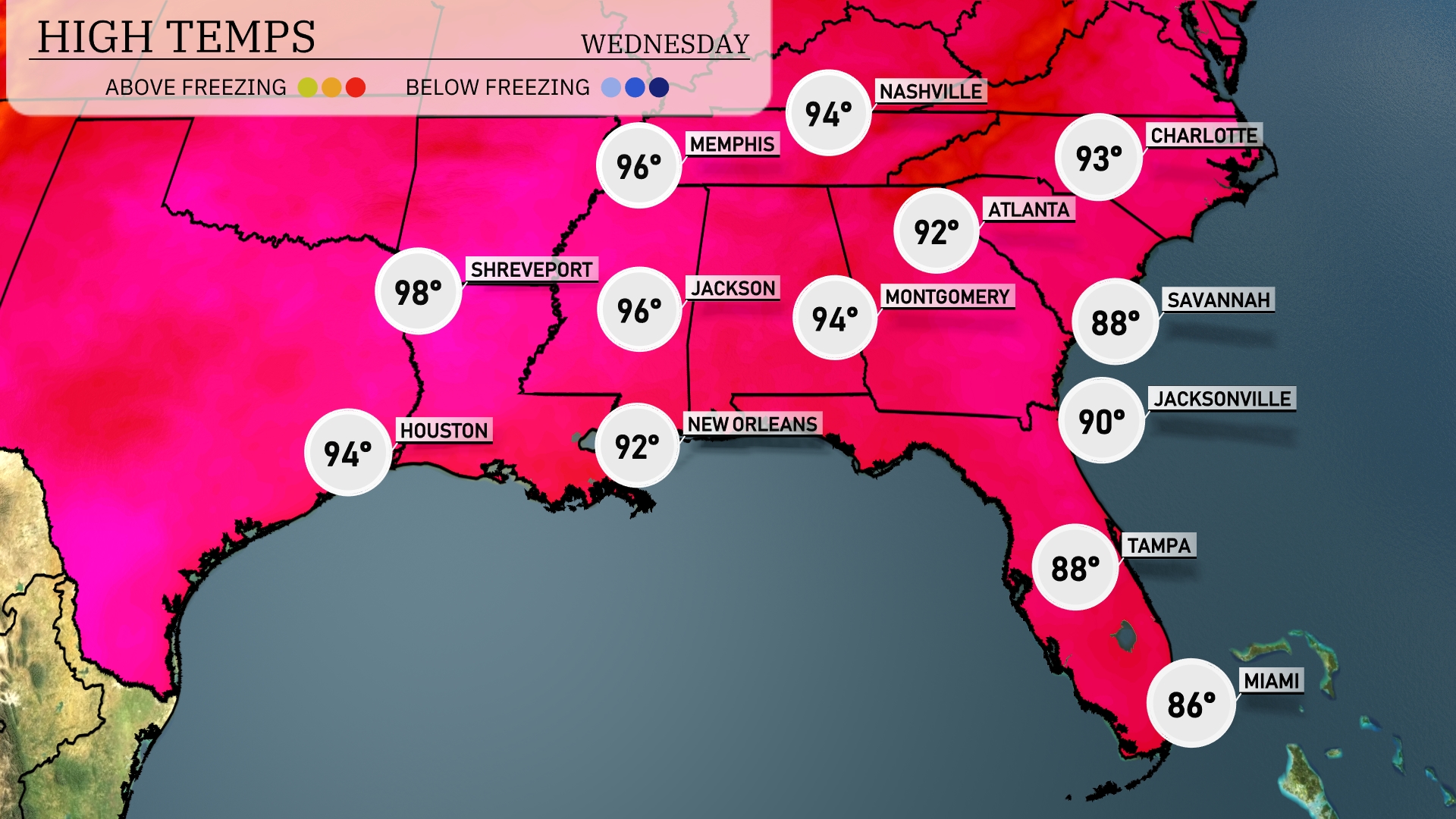
Tomorrow, the Southeast region will experience notably high temperatures, with Shreveport hitting a scorching 98 degrees and Houston not far behind at 94 degrees. Jackson is also set for a warm day at 96 degrees. In the eastern areas, Montgomery reaches 92 and Jacksonville climbs to 90 degrees, while further south, New Orleans will see a high of 92 degrees.
A cold front will make its way across the Southeast, bringing thunderstorms and the potential for severe weather, especially from New Orleans to Atlanta, late Tuesday into Wednesday. Expect heavy rain and gusty winds in areas like Jackson and Montgomery, which could lead to localized flooding given the rain forecasted over the next 24 to 48 hours. Temperatures will see a slight dip post-frontal passage, giving relief from the oppressive heat. In the immediate coastal areas, be prepared for slick roads during the morning commute Wednesday.
The UV index in Miami is expected to be very high at 8 on both Tuesday and Wednesday. With a burn time of approximately 17 minutes in direct sunlight, it’s essential to apply sunscreen and wear protective clothing to reduce sun exposure risks.
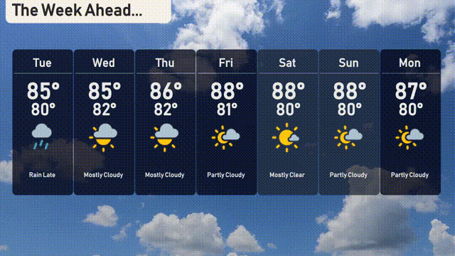
For the 7 Day Outlook in Miami:
Tuesday: Expect rain late in the day with highs reaching 85 degrees and a low of 80 degrees.
Wednesday: Mostly cloudy skies with a high of 85 degrees, cooling to 82 at night.
Thursday: Continues mostly cloudy with temperatures peaking at 86 degrees, dropping to 82 degrees by evening.
Friday: Partly cloudy conditions as temperatures climb to 88 degrees and a low of 81 degrees.
Saturday: The sun shines bright with mostly clear skies, hitting a high of 88 degrees and a low of 80 degrees.
Sunday: Partly cloudy with a high of 88 degrees and a low around 80.
Monday: More partly cloudy conditions as we wrap up the week, with temperatures reaching 87 degrees, cooling to 80 overnight.