Sizzling Miami: A Forecast of Sun, Storms, and Surprising Shifts
By
Amy Freeze
Explore the dramatic shifts in Miami's weather this week, from scorching sun to sudden storms. Stay informed on what to expect right outside your front door.
This week in Miami, weather takes you on a roller-coaster from sunny skies to stormy evenings. Check out the full forecast to plan your days better!
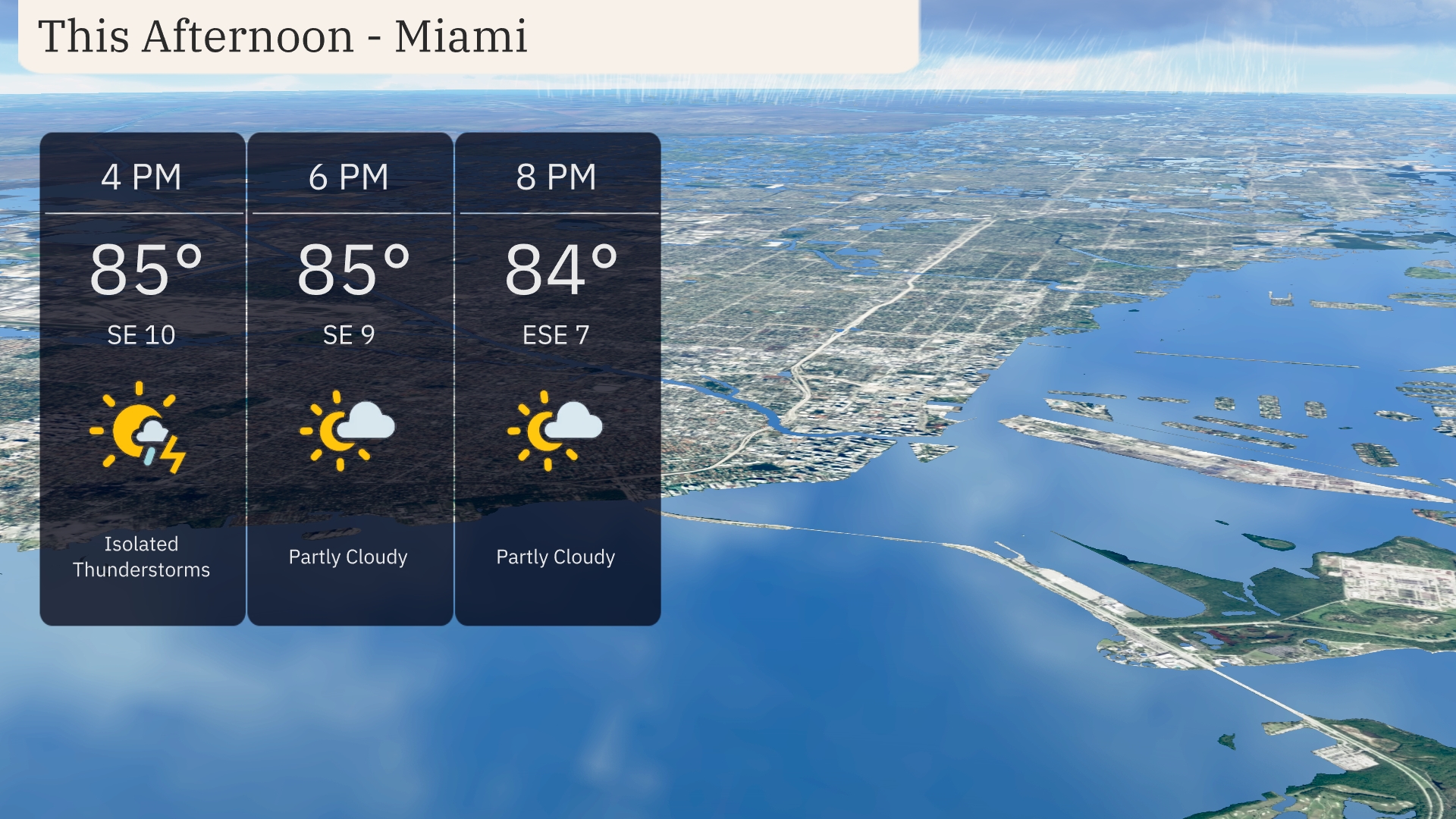
Welcome to your Southeast weather update. In Miami, expect a mix of sun and isolated thunderstorms this afternoon with temperatures peaking at 85°F. As a cold front moves in, prepare for scattered thunderstorms across the Southeast, with the potential for severe weather. Follow our full 7-day forecast and stay ahead of the weather!
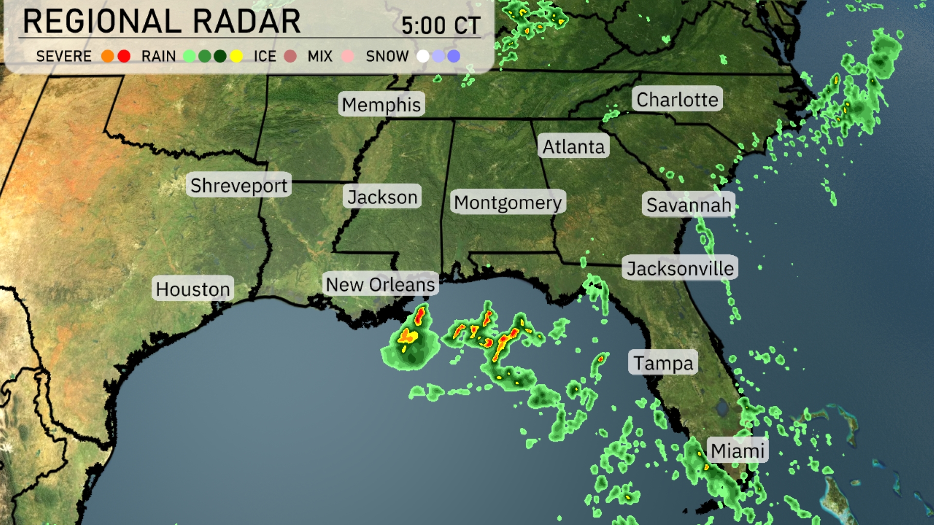
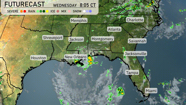
The Southeast region is bracing for active weather as scattered thunderstorms develop off the coast near New Orleans and stretch into the Gulf of Mexico. New Orleans could see thunderstorms as this system moves northward. Rain is extending eastward toward Jacksonville and is expected to affect the areas around Savannah. Cloud cover is spreading across Georgia and reaching up to Atlanta, setting the stage for potential storms later in the day.
Miami’s afternoon forecast brings temperatures holding steady at 85 degrees with a southeast wind at 10 miles per hour. Be prepared for isolated thunderstorms, so keep an eye on the sky for possible rain. By 6 PM, conditions shift to partly cloudy with a southeast wind blowing at 9 miles per hour. As we approach 8 PM, expect conditions to remain partly cloudy while temperatures gently dip to 84 degrees and the wind eases to 7 miles per hour out of the east-southeast.
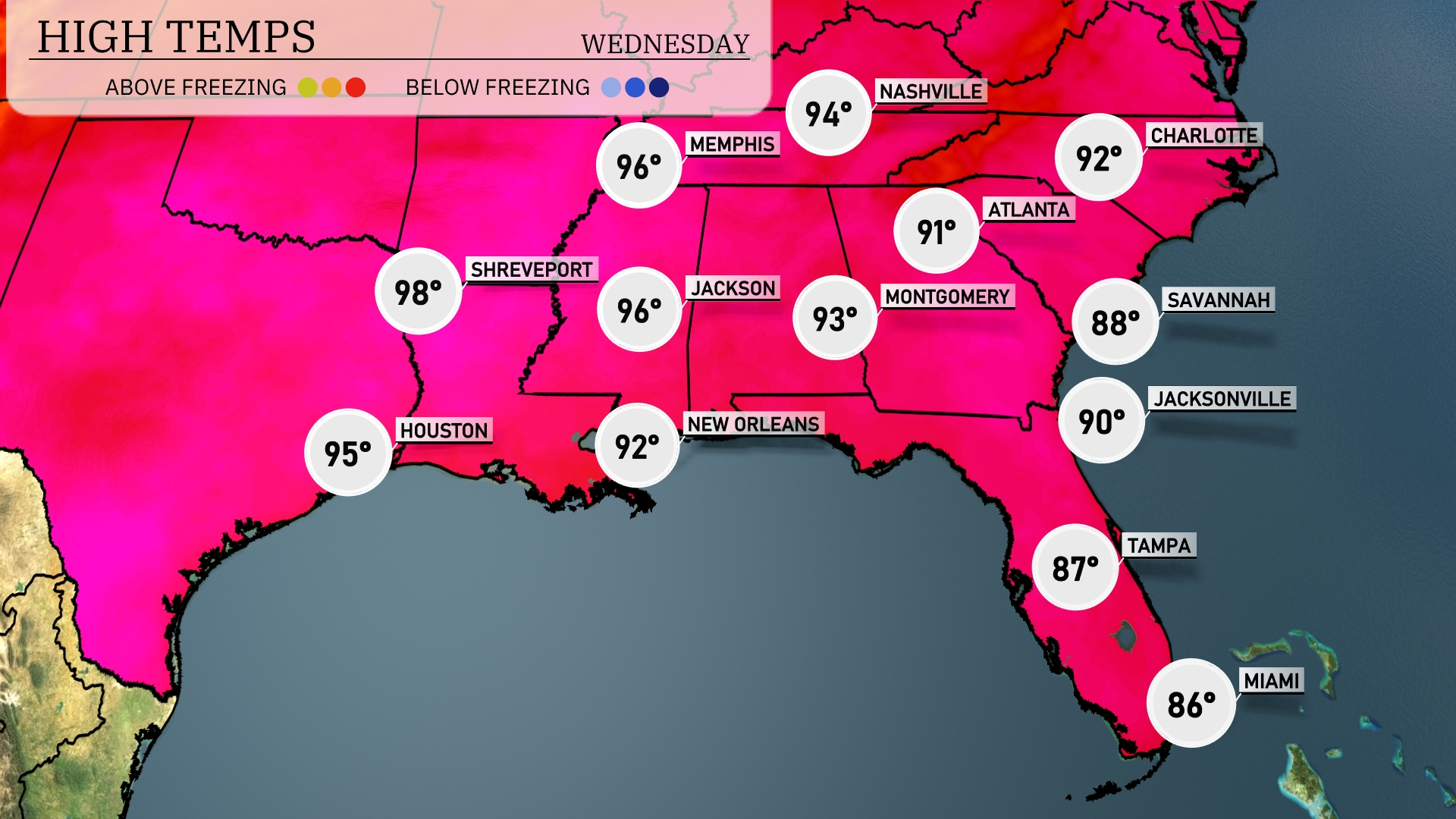
Today, the Southeast is sizzling with high temperatures. Shreveport reaches a scorching 98 degrees, while Jackson is close behind at 96. In Louisiana, New Orleans expects a high of 92. Moving east, temperatures drop slightly with Montgomery at 93 degrees and Atlanta hitting 91. Coastal cities like Jacksonville and Tampa are a bit cooler, with highs of 90 and 87 degrees, respectively, as they experience a mild onshore breeze.
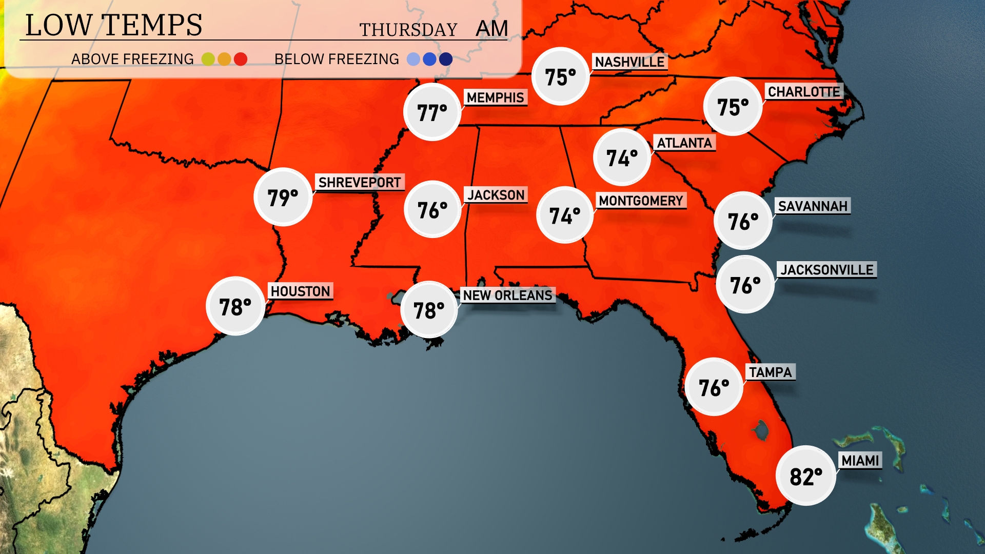
Tonight, temperatures are expected to drop to 76 degrees in Atlanta. Jacksonville will see a low of 76, while Montgomery drops to 74 degrees. Expect an even cooler night in Nashville with a low of 75. Over in Memphis, temperatures will settle at 77 degrees.
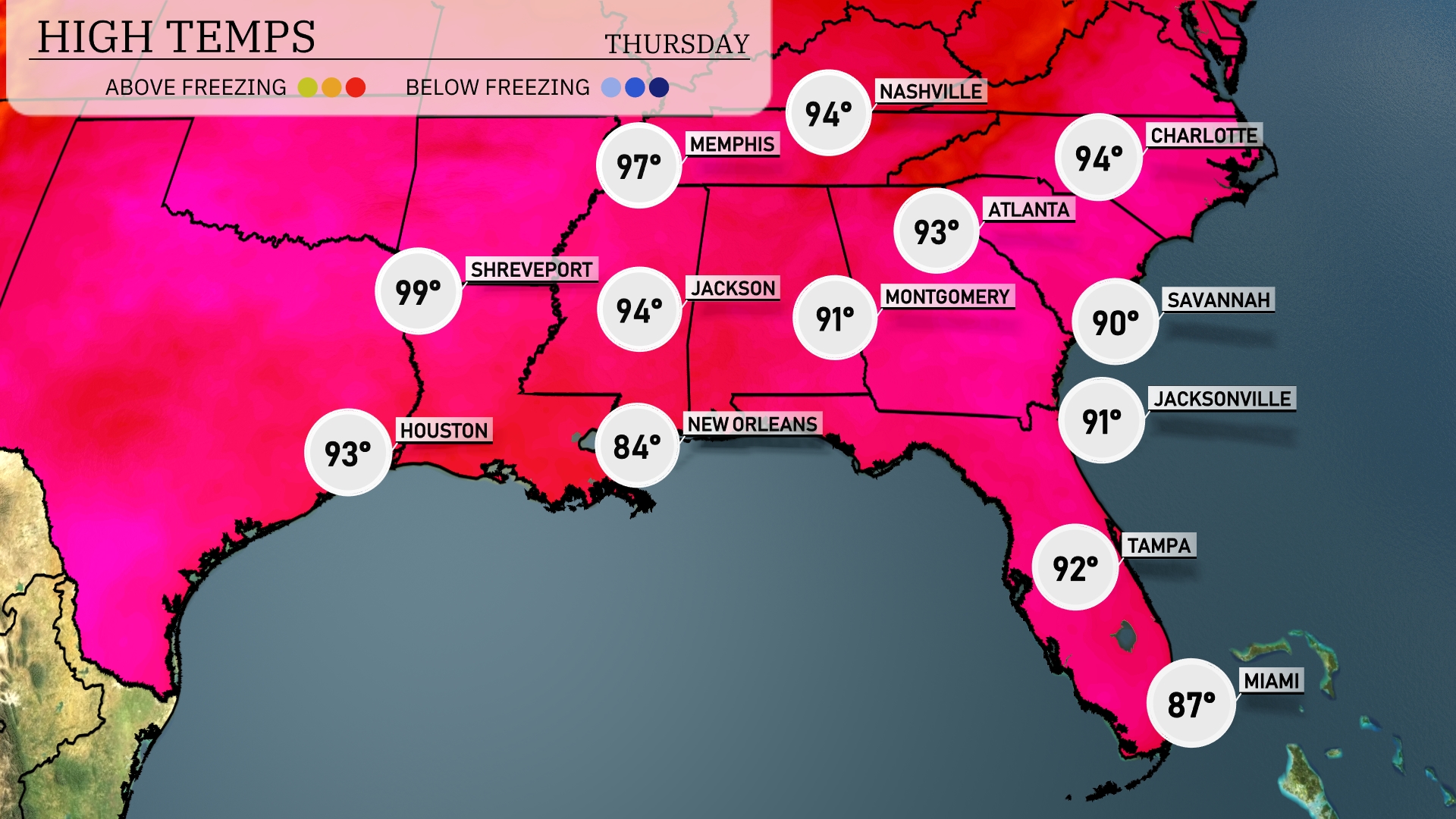
Tomorrow in the Southeast, Shreveport is expected to reach a sizzling 99 degrees, while Houston will see 93 degrees. Jackson will stay warm at 94 degrees, and Atlanta is forecasted to hit 91 degrees. In Florida, Tampa is looking at a high of 92 degrees, with Jacksonville up at 91 degrees. New Orleans will be slightly cooler at 84 degrees, indicating a notable variation across the region.
A cold front will push through the Southeast tomorrow, sparking widespread thunderstorms from Houston to Jackson. Watch for stormy conditions in the morning in New Orleans, progressing eastward into Georgia by mid-afternoon, with the potential for heavy rain and strong winds. Areas from Montgomery to Charlotte may experience isolated severe thunderstorms with the possibility of damaging wind gusts. Rainfall could surpass one inch, increasing localized flooding concerns. Behind the front, expect cooler and drier air to filter in, setting the stage for calmer weather heading into the weekend.
The UV index in Miami is extreme today with a value of 11, leading to a quick burn time of just 11 minutes in direct sunlight. On Thursday, the UV index slightly reduces to 8, offering a burn time of about 17 minutes.