Atlanta Faces Heat Wave and Storm Fronts – July 18, 2025 Weather Overview
By
Amy Freeze
Explore the dynamic weather patterns hitting Atlanta and the Southeast on July 18, from scorching heat to severe storms. Stay updated with our comprehensive forecast.
As Atlanta braces for a heat wave with highs reaching 92 degrees, severe storms threaten to disrupt the calm. Get all the details on what to expect weather-wise in your area on July 18, 2025.
The Atlanta community and surrounding Southeast areas are facing a mix of weather phenomena this July 18, 2025. With temperatures soaring to 92 degrees, Atlanta is also on alert for severe storms advancing from the Gulf. As we monitor these potential disruptions, stay updated and prepared by following our daily insights and protect yourself against extreme UV conditions with an index of 11 expected.
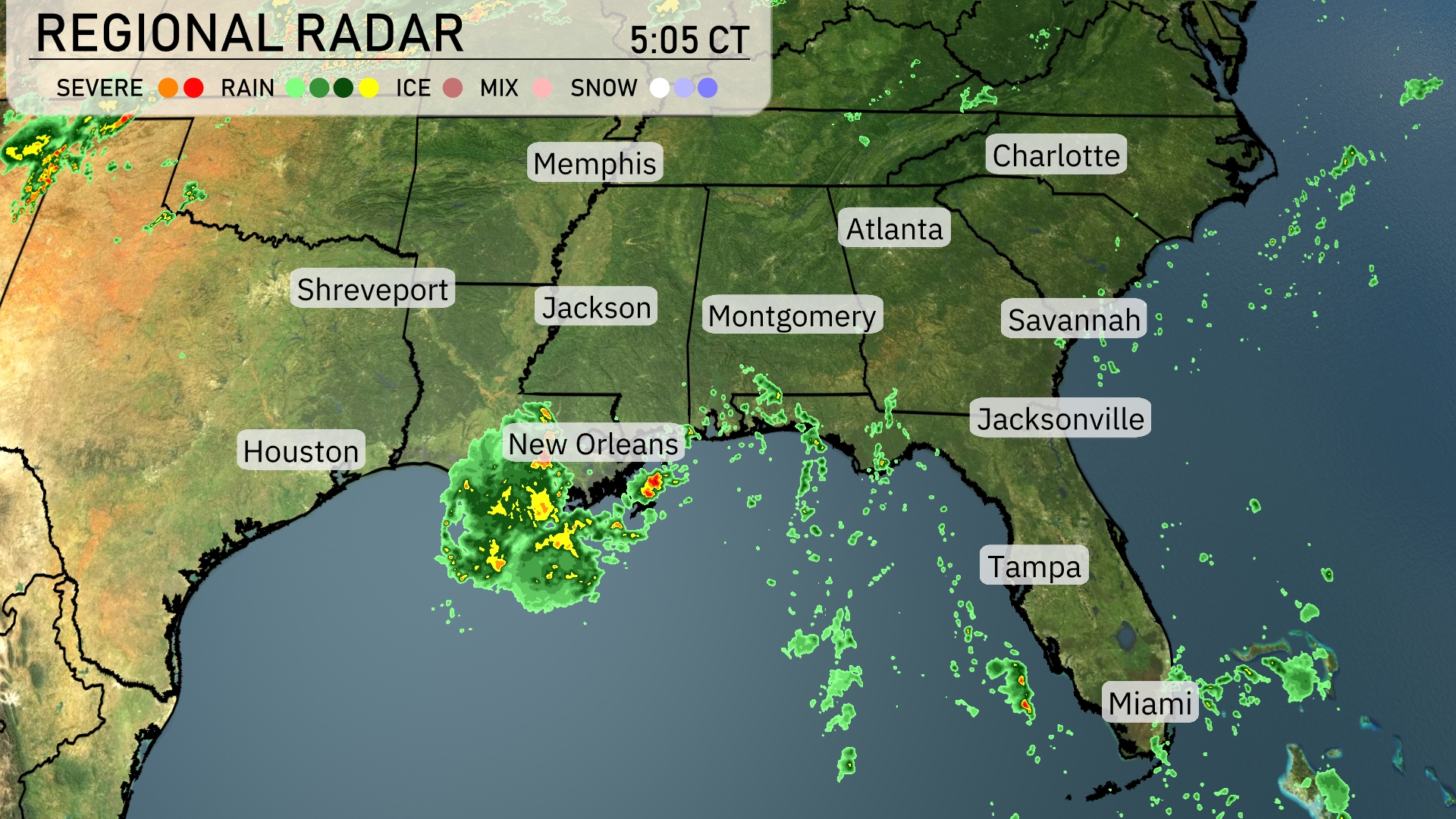
The Southeast region is braced for some active weather, with severe storms brewing over the Gulf and heading towards New Orleans. Heavy rain showers are expanding northeast into areas like Jackson, while Montgomery and Atlanta are experiencing increased cloud cover as rain advances. The radar shows that Memphis and Charlotte are dry for now, but prepping for possible incoming rain. Florida’s coast remains mostly clear with some isolated showers off the shore.
Atlanta’s afternoon brings partly cloudy skies with temperatures peaking at 91 degrees around 4 PM. Winds are blowing from the south at around 8 to 9 miles per hour. Keep an eye out for a chance of isolated thunderstorms by 6 PM, as temperatures hold steady at 90 degrees. By 8 PM, skies remain partly cloudy with the temperature dipping slightly to 86 degrees.
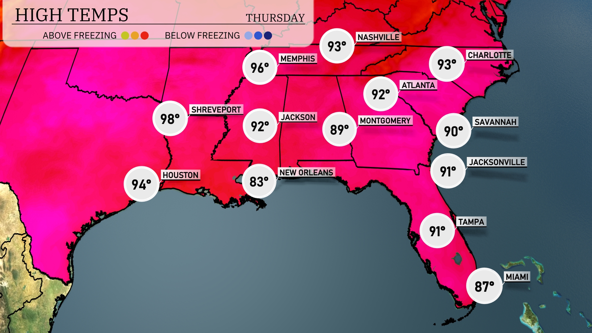
Today’s regional high temperatures in the Southeast are reaching impressive levels. Shreveport is reporting a searing high of 98 degrees, while Houston comes in slightly cooler at 94 degrees. In Jackson, temperatures rise to 92, and Montgomery sees a comfortable high of 89 degrees. Farther east, Atlanta hits 92, while Jacksonville is a warm 91. As we move south to Tampa, the high is around 91 degrees, and Miami experiences a cooler afternoon at 87 degrees.
Tonight, look for a low of 74 degrees in Jackson and Montgomery. Memphis will drop slightly to 75 degrees, while Nashville cools down to 73. Expect temperatures to be a bit warmer along the coast, with Jacksonville and Savannah at 75 degrees and a balmy 82 in Miami. Houston remains steamy at 78 degrees, keeping the warm air pattern in place for much of the Southeast.
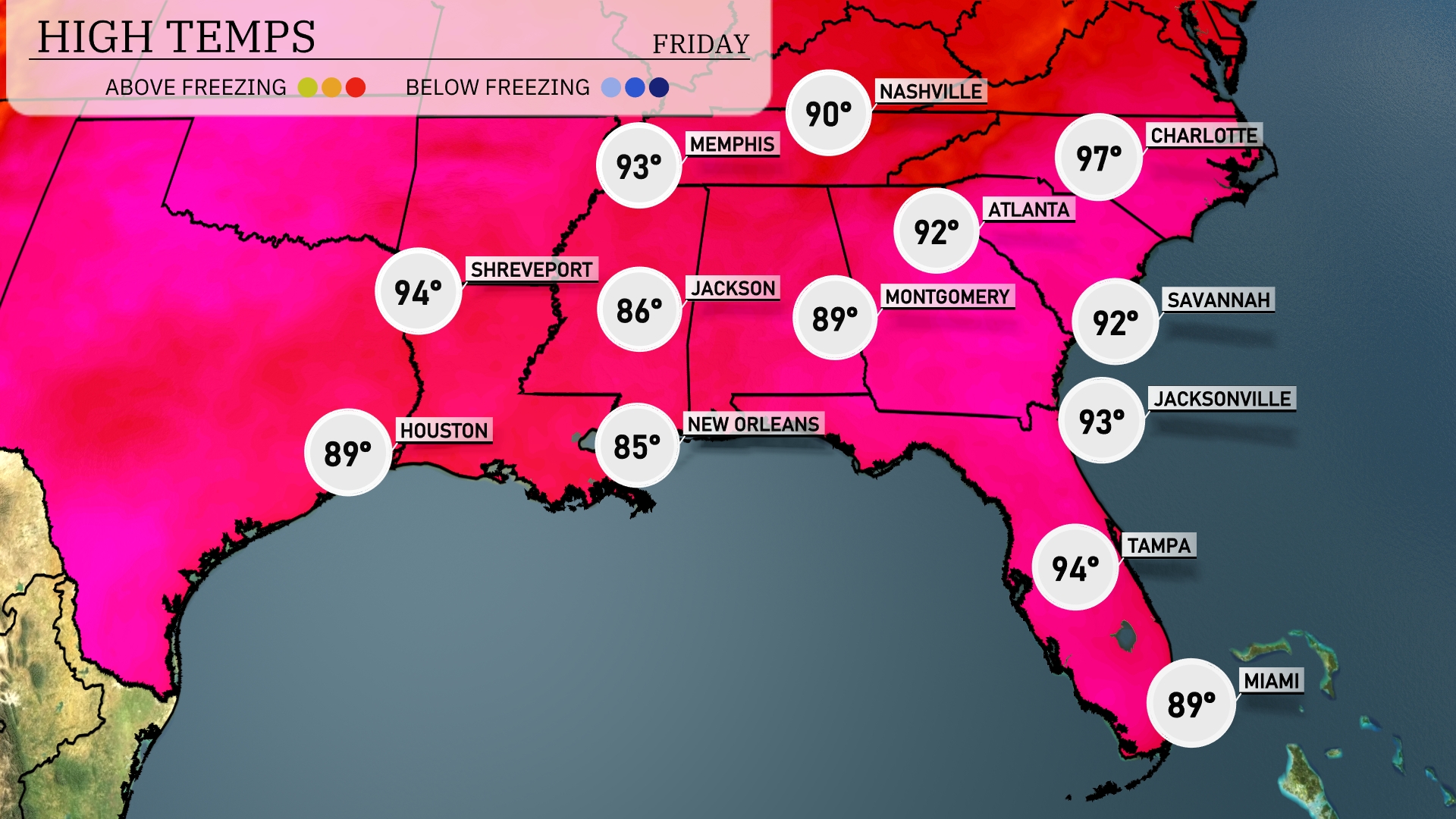
Tomorrow in the Southeast, expect a heat wave with Charlotte hitting a scorching 97 degrees, well above average for this time of year. Atlanta will see a high of 92, while Montgomery reaches 89 degrees. Savannah will experience similar warmth at 92 degrees, with Jacksonville slightly higher at 93. In the Gulf region, Houston is forecasted to be a comfortable 89 degrees, while New Orleans warms up to 85. Shreveport will not be left out, with high temperatures expected to reach 94 degrees.
A dynamic weather pattern is on the horizon for the Southeast tomorrow. Thunderstorms will advance eastward from Mississippi through Alabama into Georgia, aligning with the morning commute in Atlanta. Beware of localized downpours and gusty winds, particularly from Montgomery to Savannah. Over the next 24 to 48 hours, temperatures will dip slightly post-storm, offering a cooler reprieve by Thursday evening.
The UV index in Atlanta is an extreme 11 on both Thursday and Friday, with a burn time of only 11 minutes. It’s crucial to apply sunscreen, wear protective clothing, and avoid the sun during peak hours to prevent skin damage.