Sizzling Insights: Evening Heat and Storm Chances Across the Southwest
By
Amy Freeze
Explore the diversified weather patterns of Salt Lake City and its neighboring regions. From scorching highs to unexpected storm activities, get informed on what to anticipate in the coming days.
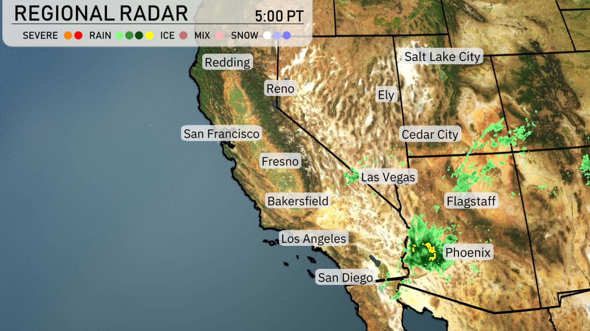
Tonight in Salt Lake City, temperatures cool as we approach midnight, with skies clearing up. However, stormy surprises await near Phoenix, with areas from Las Vegas to Los Angeles enjoying clear skies.
This evening in Salt Lake City, as you enjoy the warmth, there’s a storm brewing in Phoenix. Flagstaff feels the sprinkle, while San Diego stays cloudy yet dry. In our detailed update, read about the fluctuating temperatures from morning heat to cooler evenings across the Southwest. Discover which areas will face rain and which will stay dry. Plus, a peek into the 7-day forecast for Salt Lake City reveals shifting patterns, from cloudy to mostly sunny. Get all the details: https://amyfreeze.ai/
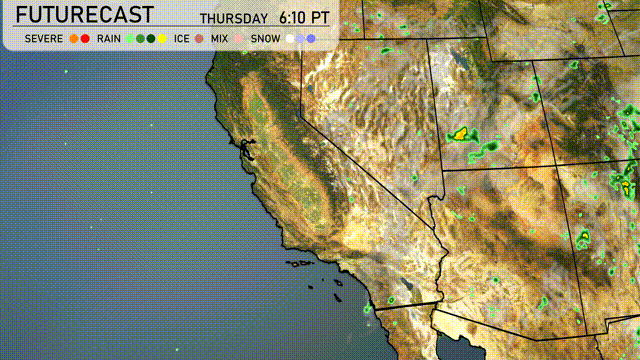
Over the Southwest region, significant storm activity is centered around Phoenix, with severe thunderstorms pushing eastward. Flagstaff is experiencing lighter rain showers, while areas from Las Vegas to Los Angeles remain dry and clear. San Diego is seeing more cloud cover, although it stays without precipitation. For Redding, Reno, and Ely, expect dry conditions with minimal cloud interference.
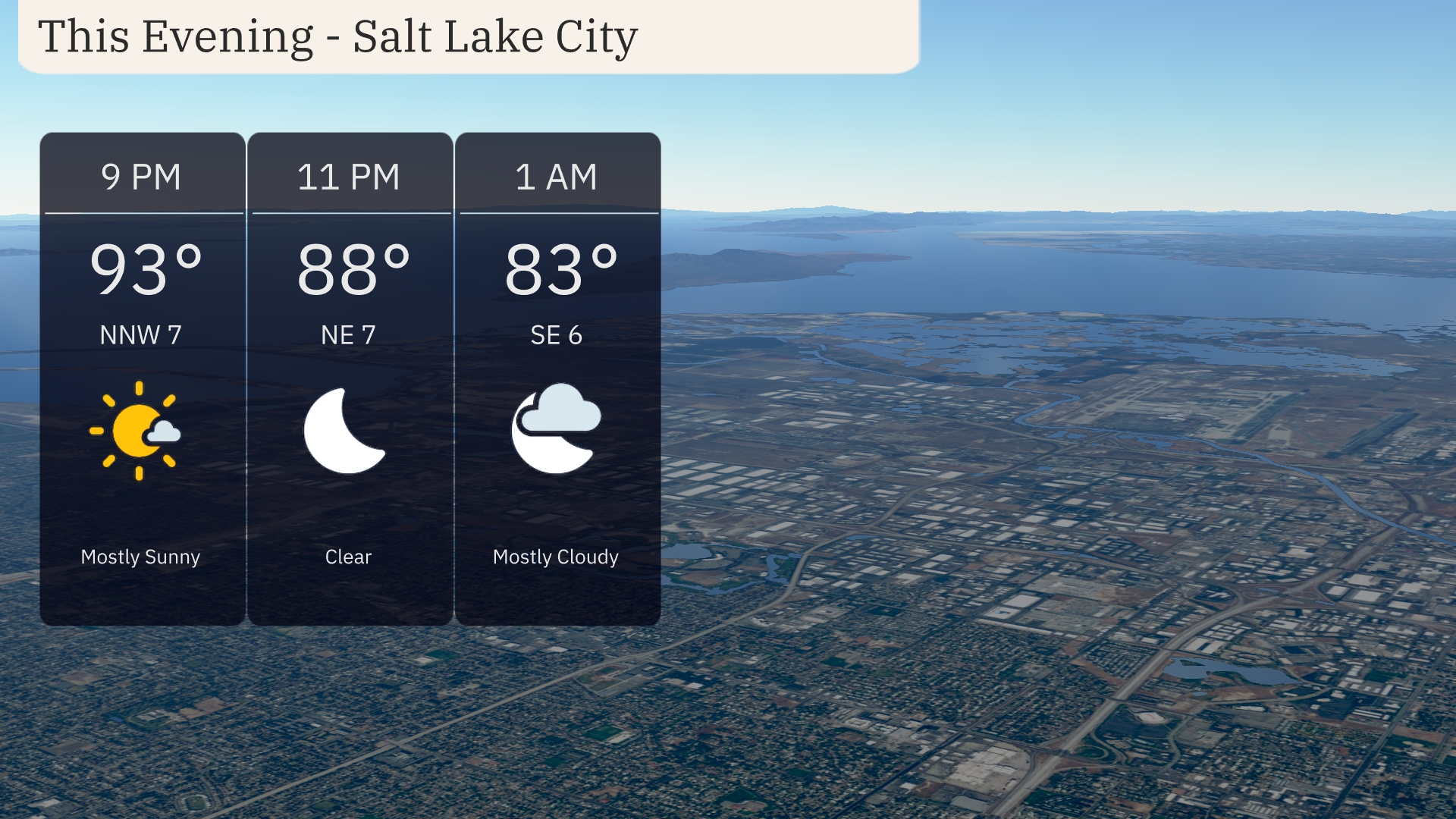
In Salt Lake City this evening, temperatures start off warm at 93 degrees by 9 PM, with a mostly sunny sky and a gentle northwest wind at 7 mph. By 11 PM, the temperature cools to 88 degrees with clear skies, while a light northeast wind persists. As we head into the early morning hours at 1 AM, expect mostly cloudy conditions with the temperature dropping to 83 degrees and a southeast wind at 6 mph.
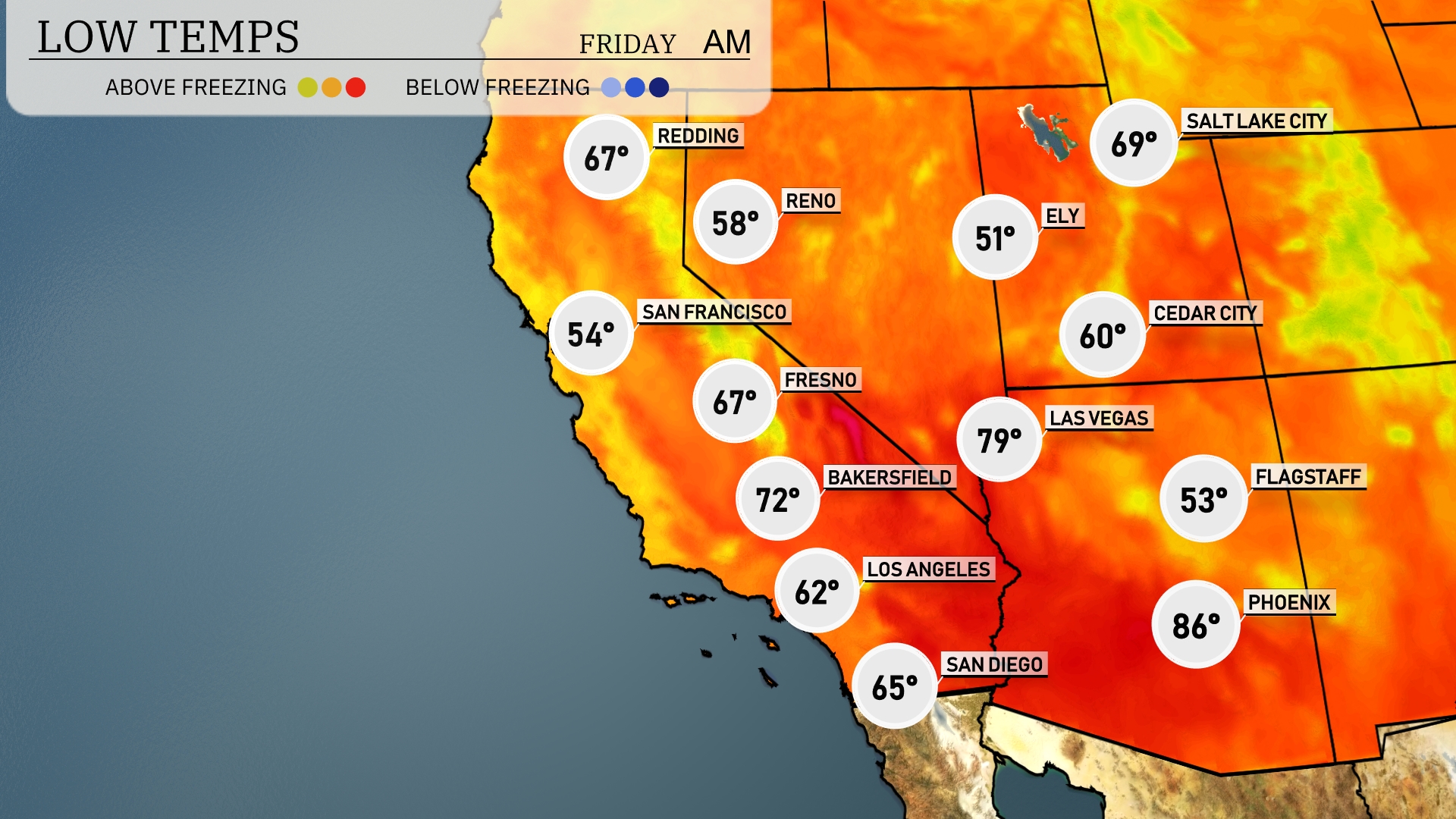
Tonight, lows in the Southwest will vary significantly, with Redding dropping to 67 degrees. San Francisco is cooler at 54, while Fresno posts a low of 67. Expect chilly temperatures in Flagstaff at 53 and Ely dipping to 51. Las Vegas will remain warmer at 79, but it’s a stark contrast to the overnight lows in the higher elevations.
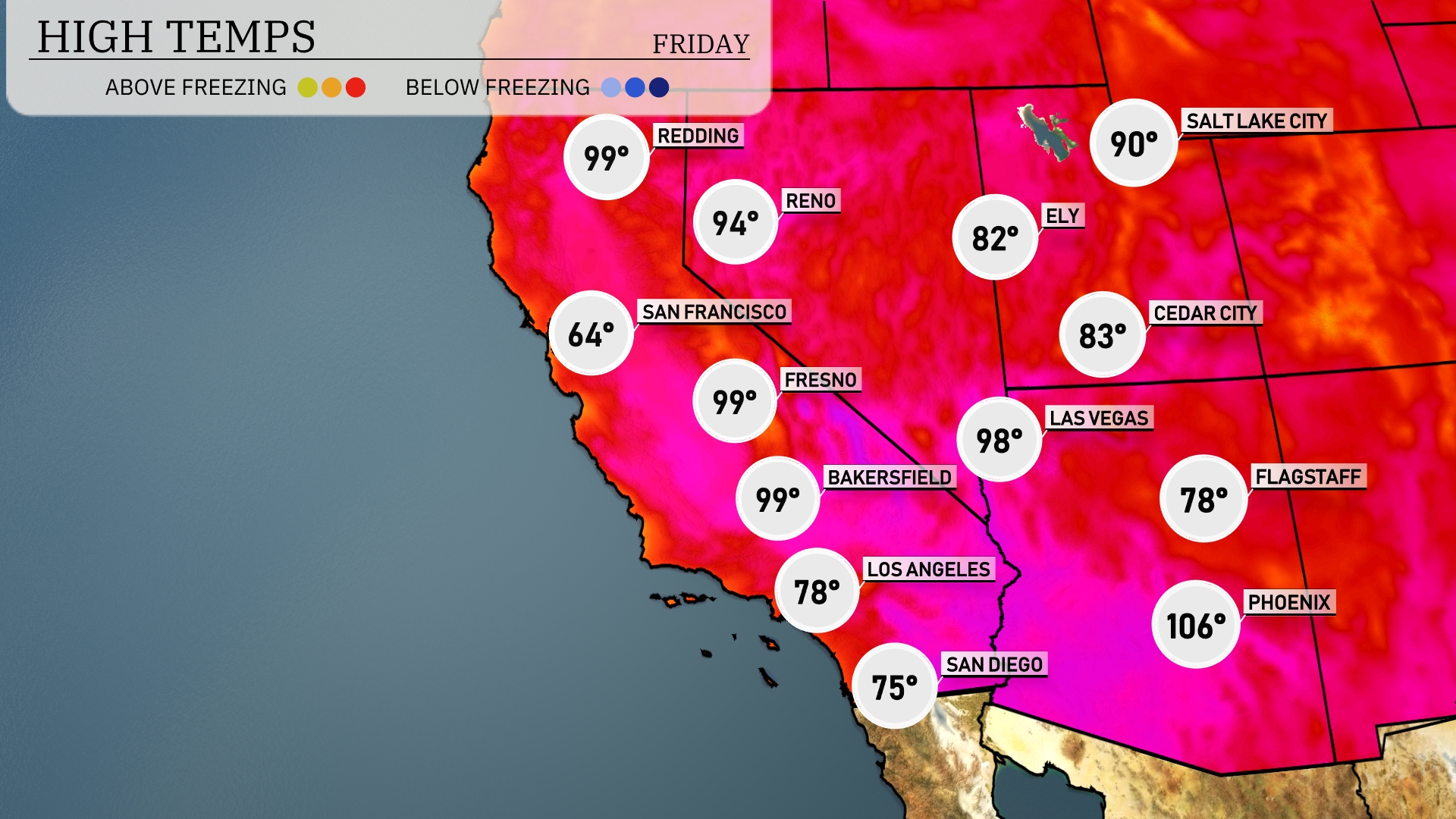
Tomorrow in Phoenix, expect scorching temperatures to soar to a high of 106 degrees, significantly above average for this time of year. Las Vegas will be right behind with a high of 98 degrees, also on the warm side. In Los Angeles, temperatures will be more moderate at 78 degrees, while Bakersfield and Fresno are heating up, both reaching around 99 degrees. San Francisco remains cooler at 64 degrees, making it a stark contrast to the inland areas.
On the Southwest futurecast, a dry and warm pattern continues for the desert areas into tomorrow. Northern California will experience scattered showers and possible thunderstorms late in the day, especially over higher elevations. Coastal areas, including Los Angeles, face possible morning fog but will clear by afternoon with mild temperatures. The Sierra Nevada region should prepare for light rain and breezy conditions. Expect cooler temperatures to edge into Southern California over the next 48 hours.
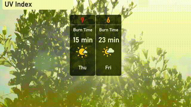
Salt Lake City’s UV index will peak at 9 today, signaling a high risk of harm from unprotected sun exposure, with a burn time as short as 15 minutes. On Friday, the index decreases to 6, offering a moderate risk with burn time extending to 23 minutes.
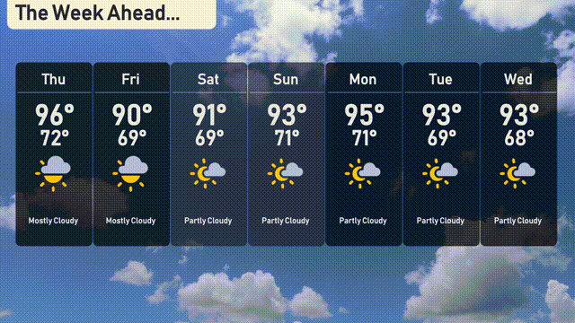
Here’s the 7-day outlook for Salt Lake City:
Thursday: Expect a mostly cloudy day with a high of 96 degrees and a low of 72 degrees.
Friday: Mostly cloudy skies continue with temperatures peaking at 90 degrees and dipping to 69 degrees.
Saturday: Partly cloudy conditions with a high around 91 degrees and a low of 69 degrees.
Sunday: Partly cloudy with a high reaching 93 degrees and a low near 71 degrees.
Monday: Mostly sunny, the temperature will rise to 95 degrees with a nighttime low of 71 degrees.
Tuesday: A mix of sun and clouds with a high of 93 degrees and a low of 69 degrees.
Wednesday: Partly cloudy skies with temperatures reaching a high of 93 degrees and a low of 68 degrees.