From Rains to Rays: Navigating Chicago’s Dynamic Weather Patterns
By
Amy Freeze
Catch the latest on Chicago's weather as we transition from storms to clear skies! Insights, tips, and more.
Explore how Chicago’s weather is shifting from gusty storms to serene sunshine in our latest weather snapshot.
Chicago’s skies are telling a tale of transition, from today’s vehement storms sweeping across the Midwest to the calm, sunny days on the horizon. This detailed blog post delves into the nuances of our local weather, providing predictions and precautions for navigating what Mother Nature has in store. From safety tips during severe storms to enjoying the balmy, clear days, stay informed and prepared with our comprehensive weather forecasts.
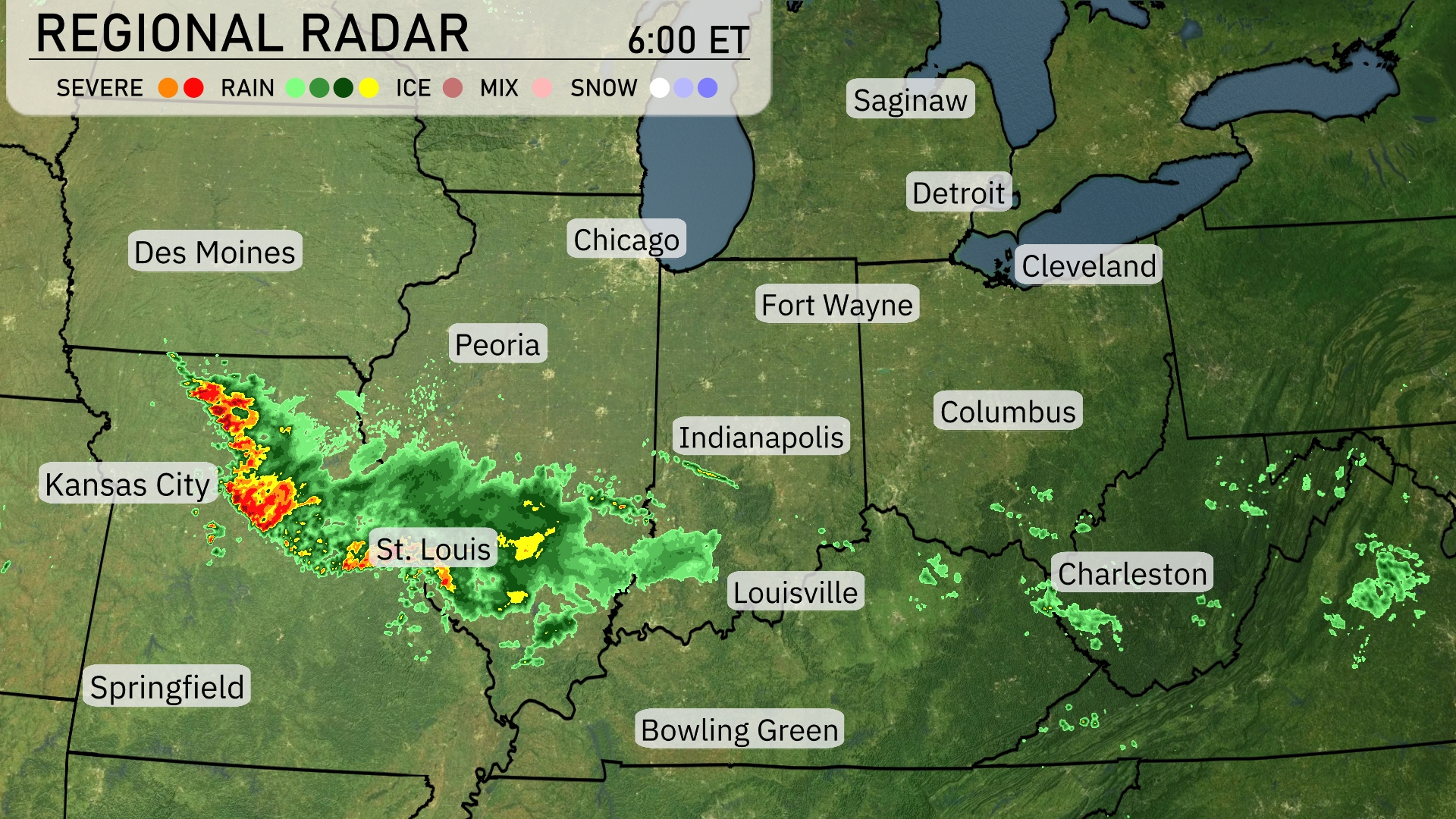
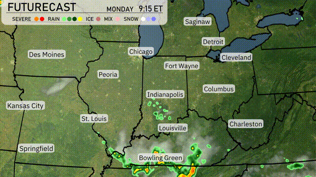
A line of strong storms is advancing from Kansas City toward St. Louis, where heavy rainfall and potential severe weather are currently impacting the area. Light rain extends southeastward from Indianapolis to Louisville, creating a damp start to the morning. Heavier showers with isolated thunderstorms stretch from Springfield toward the Mississippi River. Areas such as Fort Wayne and Columbus are experiencing cloud cover with lighter rain expected to move in later.
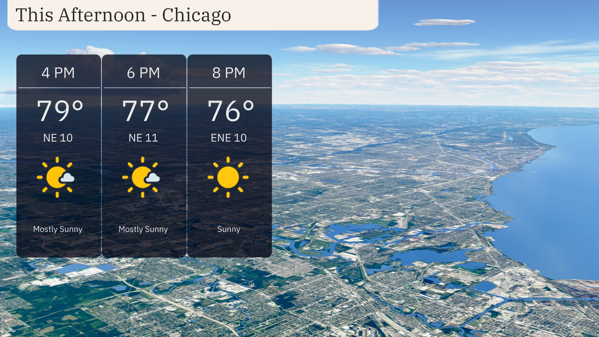
Afternoon temperatures in Chicago remain warm, peaking at 79 degrees with a gentle northeast wind around 12 miles per hour. Clouds will thin out slightly as the day progresses, transitioning from mostly sunny to clear skies by early evening. The temperature will gradually decrease to 76 degrees by 8 PM, maintaining a calm weather pattern.
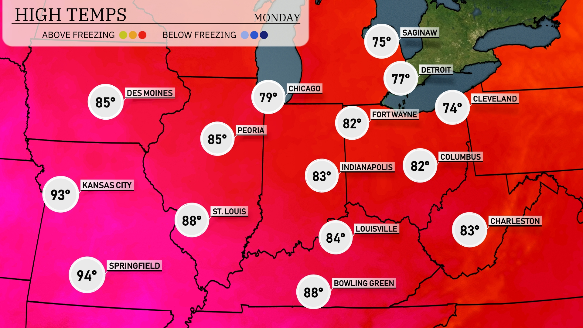
In the Midwest today, temperatures are heating up nicely. Kansas City is expected to reach a high of 93 degrees, while Springfield could see temperatures soar to 94. St. Louis will enjoy a warm afternoon with a high of 88 degrees, and Peoria temperatures will hit 85. Chicago is cooler at 79, and Fort Wayne sits at a comfortable 82 degrees.
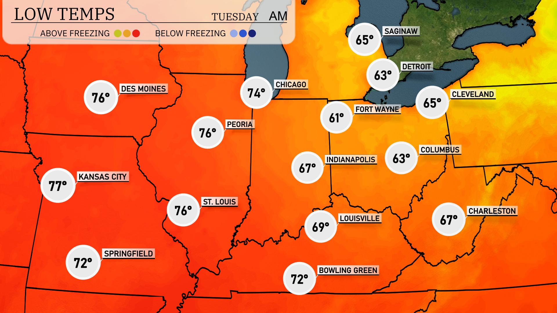
Tonight, expect low temperatures to settle around 67 degrees in Charleston and 61 in Indianapolis. Chicago will cool down to 74 degrees, while Des Moines and St. Louis remain warmer at 76 degrees. Kansas City rounds out the region with a mild low of 77 degrees.
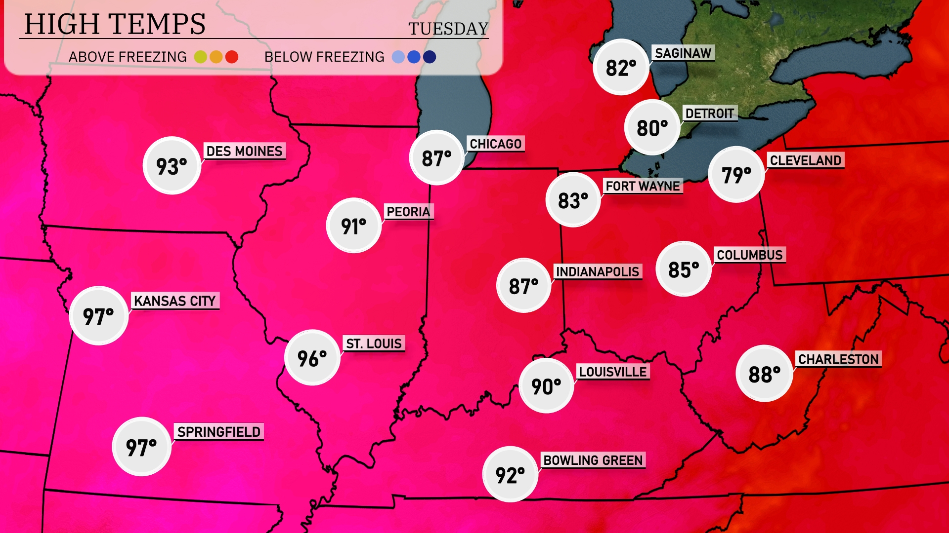
Tomorrow in the Midwest, we’re expecting a heat wave with highs peaking in the upper 90s. Kansas City and Springfield are forecasted to reach 97 degrees, while St. Louis will not be far behind at 96. Peoria is looking at a high of 91 and Indianapolis will warm up to 87 degrees. These temperatures are significantly above average for this time of year, driven by high pressure building over the region. Expect plenty of sunshine and warm conditions as this pattern continues.
A shifting weather pattern in the Midwest tomorrow as a cold front pushes through the region. Expect scattered thunderstorms from Indianapolis through Cincinnati, with potential for localized heavy rainfall and gusty winds. The afternoon in Chicago stays breezy with partly cloudy skies and cooler temperatures moving in by evening. Watch out for isolated severe thunderstorms particularly in parts of southern Illinois and Indiana.
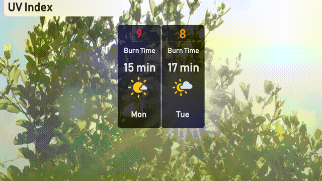
The UV index in Chicago today is 9, suggesting a burn time of about 15 minutes under direct sunlight—be sure to use sunscreen and protective clothing. Tomorrow, the UV index lowers to 8, with a slight increase in burn time to 17 minutes.