Miami and Southeast Weather Forecast: A Mix of Sun, Heat, and Storms
By
Amy Freeze
Explore today's weather dynamics across Miami and the Southeast, featuring a mix of high temperatures, potential storms, and sunny intervals. Get the full seven-day forecast and tips for staying safe.
Discover today’s weather forecast for Miami and the Southeast. From sunny skies in Miami to storm warnings in New Orleans, get all the details in our latest blog post!
Welcome to our detailed weather update for Miami and the Southeast U.S.! This afternoon, Miami enjoys partly cloudy skies with temperatures in the high 80s, creating perfect conditions for an outdoor stroll. However, a cold front approaching from the west is brewing storms from Houston to Mobile, escalating to severe weather in New Orleans. Prepare for potential flooding and ensure you’re weather-ready! For more insights and safety tips, visit our blog at https://amyfreeze.ai/
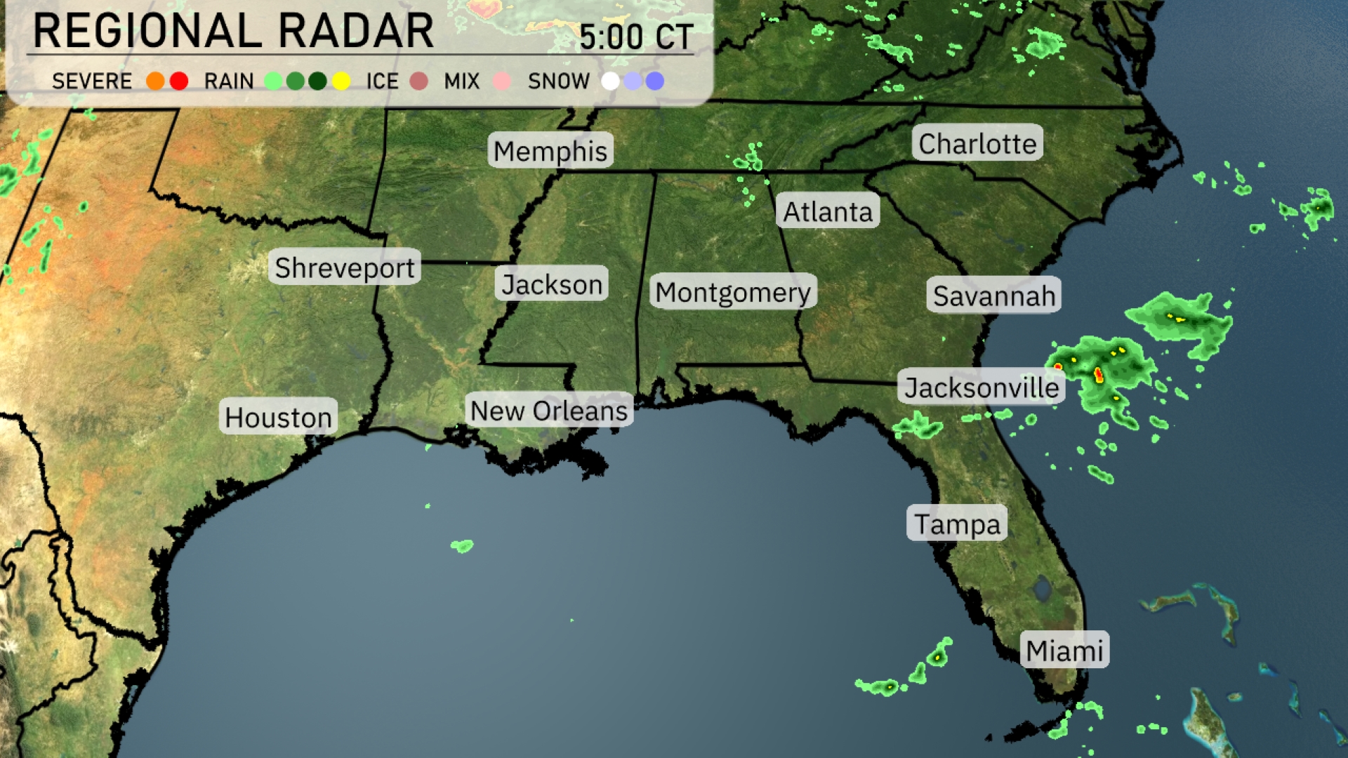
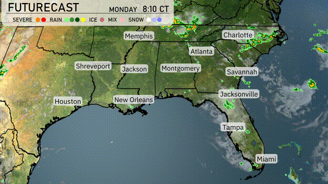
A cluster of storms is seen off the coast of Jacksonville, moving into the Atlantic, providing some sunshine for Florida’s northern cities. Across Georgia, clouds are thickening as rain showers roll in, spreading toward the Carolinas, particularly impacting areas around Charlotte. The northern part of the Southeast, including Memphis and Jackson, remains relatively clear, with only isolated patches of light rain. Houston enjoys dry conditions, and scattered storms can be seen approaching New Orleans from the west.
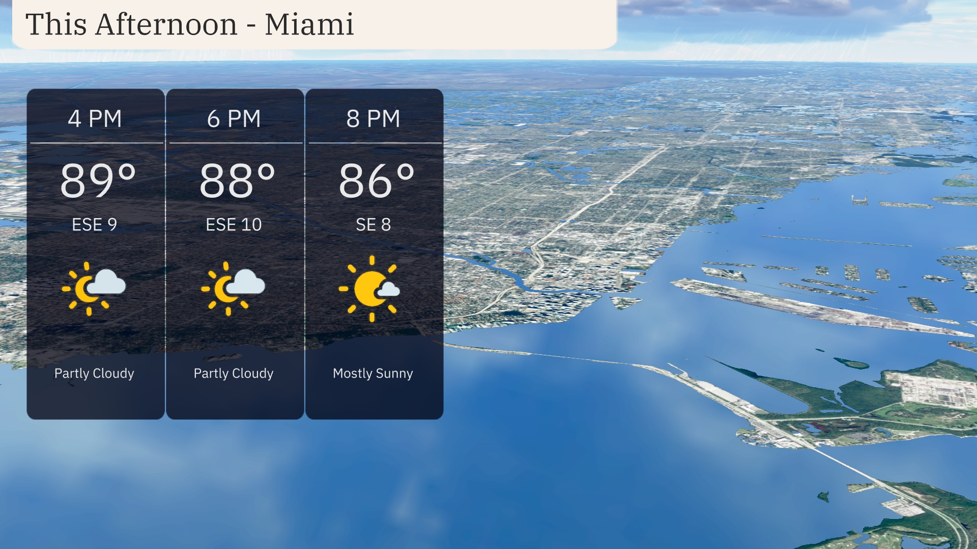
Temperatures in Miami this afternoon will be in the high 80s, with highs of 89 degrees at 4 PM, dropping to 86 degrees by 8 PM. Winds are coming from the east-southeast at 9 to 10 miles per hour, adding a gentle breeze to the partly cloudy skies.
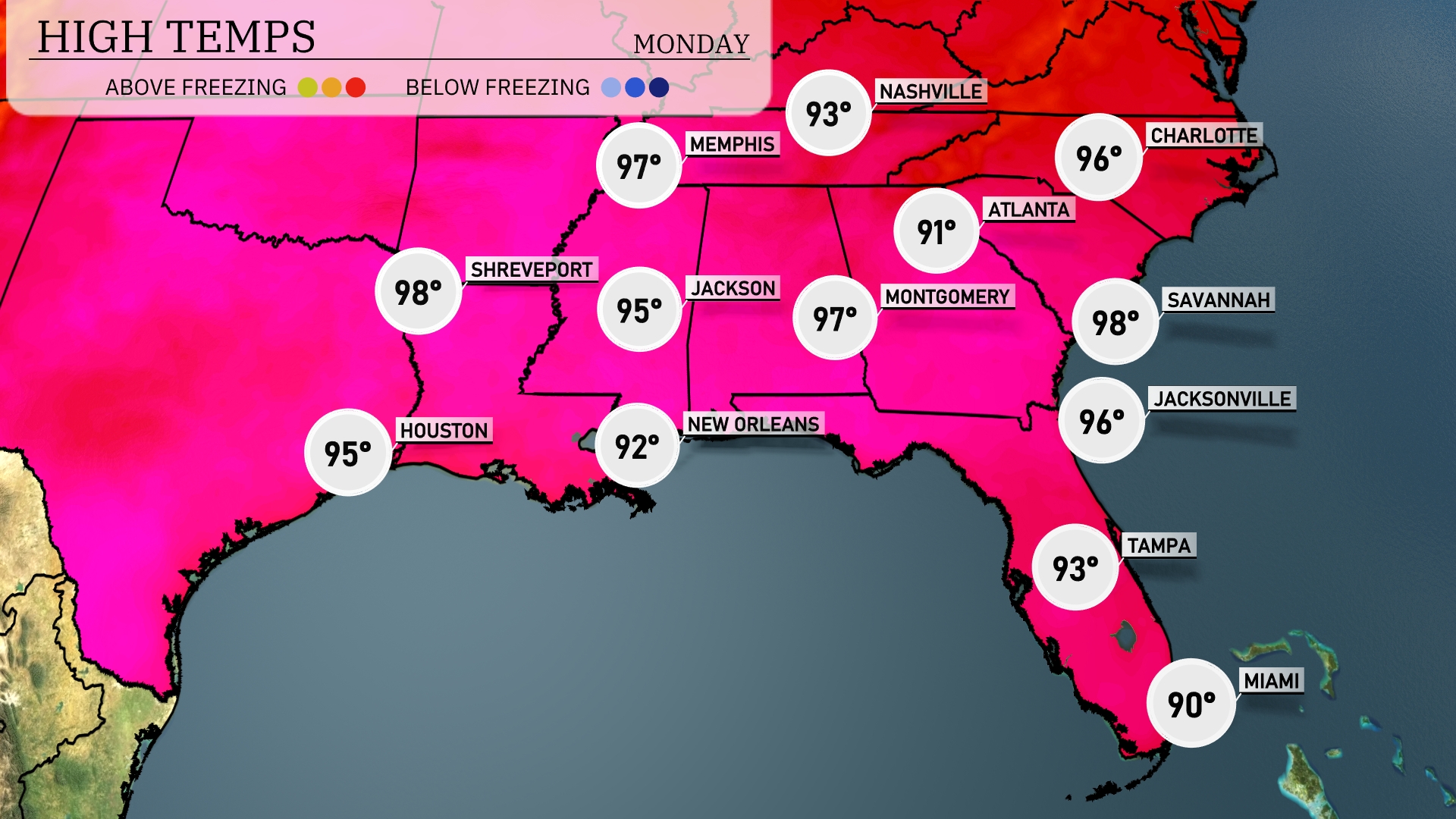
Today’s regional high temperatures in the Southeast are sizzling. Savannah leads the way with a scorching high of 98 degrees, closely followed by Shreveport at 98 and Montgomery at 97. Jacksonville checks in with a solid 96 degrees, while Atlanta stays a bit cooler at 91. New Orleans will reach a high of 92 degrees, providing some relief from the heat but still quite warm. In Florida, Tampa sees 93 degrees, with Miami a bit cooler at 90 degrees due to coastal influences.
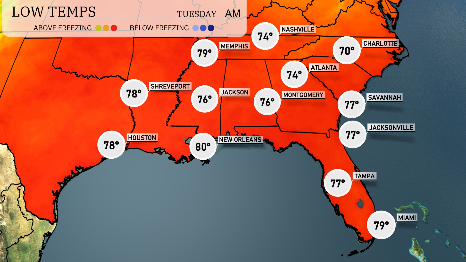
Tonight, Memphis will cool down to 74 degrees, while Nashville will be slightly lower at 72. Atlanta is expected to drop to 74 degrees, and Montgomery will see a low of 76. In the coastal areas, Jacksonville and Tampa will both remain warm at 77 degrees, with South Florida’s Miami hitting 79.
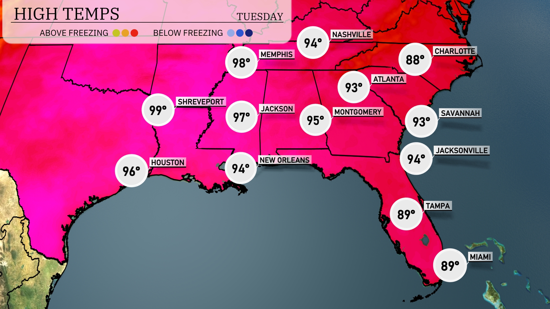
Tomorrow, we’re looking at sweltering temperatures across the Southeast. Memphis will hit a scorching 98 degrees, while Jackson isn’t far behind with a high of 97. In Louisiana, New Orleans will warm up to 94, and Shreveport is expected to reach a blazing 99. Atlanta and Montgomery are forecasting highs of 93 and 95, respectively, which are well above average for this time of year. Across Florida, both Miami and Tampa will see comfortable highs around 89 degrees, although humidity will be a factor.
Prepare for an active weather day across the Southeast tomorrow. A cold front is making its way from the west, expected to bring thunderstorms from Houston to Mobile during the afternoon and evening. New Orleans may experience strong to severe storms, so it’s essential to stay weather-aware. Keep an eye out for potential rainfall accumulation causing localized flooding, especially in low-lying areas. By late Wednesday, temperatures will drop slightly with clearing skies, offering a temporary break from the stormy conditions.
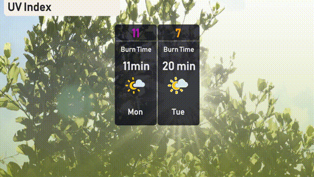
In Miami, today’s UV index is very high at 11, with a burn time of just 11 minutes, so make sure to apply sunscreen frequently and seek shade when possible. Tomorrow, the UV index will drop slightly to 7, with a 20-minute burn time, but it’s still crucial to protect your skin. Remember to use broad-spectrum sunscreen and wear a hat and sunglasses to enjoy the sunny days safely!