Weather Whiplash: Atlanta and Southeast Dance Between Sunshine and Storms
By
Amy Freeze
Evening clear skies in Atlanta contrast with unexpected storms brewing over northern Florida. Stay updated with the latest weather conditions.
Explore a snapshot of today’s weather trends across Atlanta and its neighboring regions, from serene conditions to emerging storm threats.
As the Southeast braces for varied weather patterns, Atlanta enjoys a calm evening while storms cast a shadow over Florida. Find all about temperatures, storm predictions, and safety tips for the coming days in our in-depth analysis. Dive deeper into how these weather dynamics could affect your week ahead!
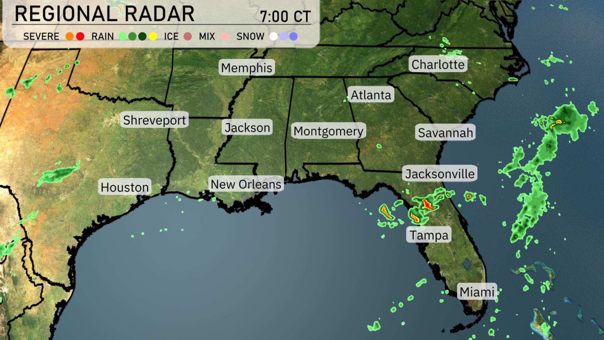
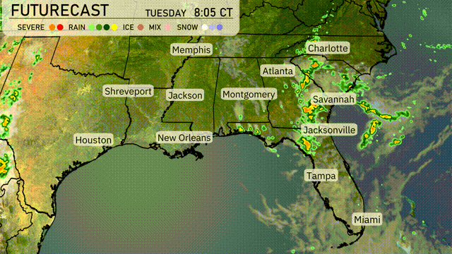
A line of scattered storms is developing over northern Florida, with Jacksonville and surrounding areas experiencing showers. Rain is also on the move near Tampa, pushing towards the southeast. The rest of the Southeast, including cities like Atlanta, Charlotte, and Montgomery, remains dry with partly cloudy skies. There are no severe weather conditions reported, allowing much of the region to enjoy a calm start to the day.
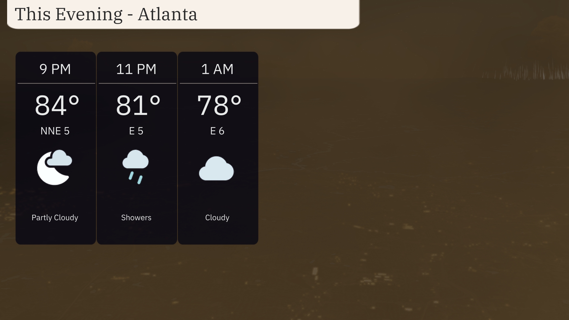
For this evening in Atlanta, the weather will start partly cloudy with temperatures at 84 degrees around 9 PM. Showers are expected to develop by 11 PM as temperatures dip to 81 degrees, with a shift to light winds from the east at 5 miles per hour. By 1 AM, clouds will persist with temperatures cooling to 78 degrees, maintaining an east wind at 6 miles per hour.
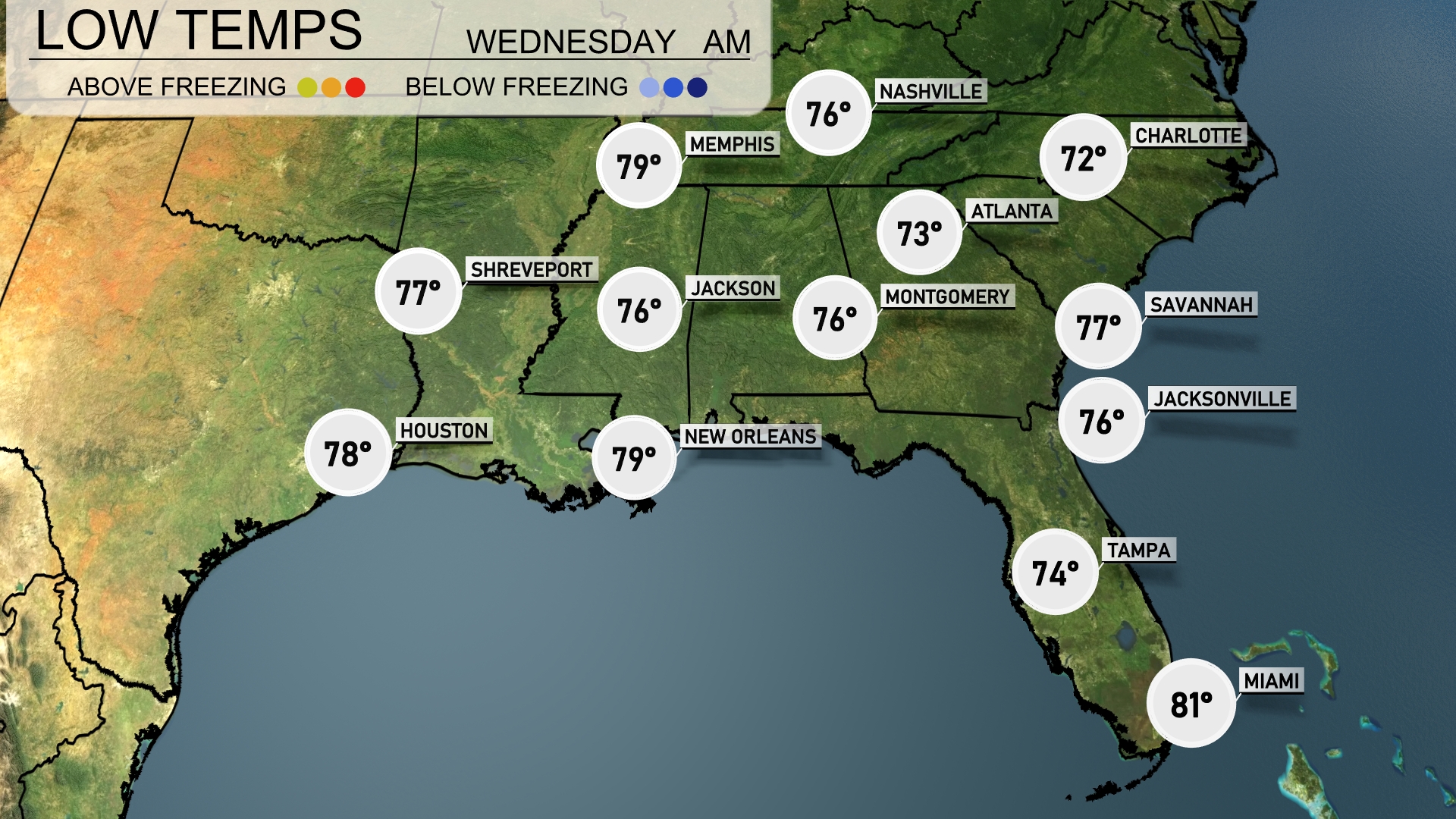
Tonight in Memphis, expect a low of 79 degrees. Shreveport will see a slightly cooler night with a low of 77. New Orleans is also warmer at 79 degrees, while Jacksonville will drop to 76. Further north, Nashville is forecasted for a low of 76, and Atlanta will cool to 73 degrees.
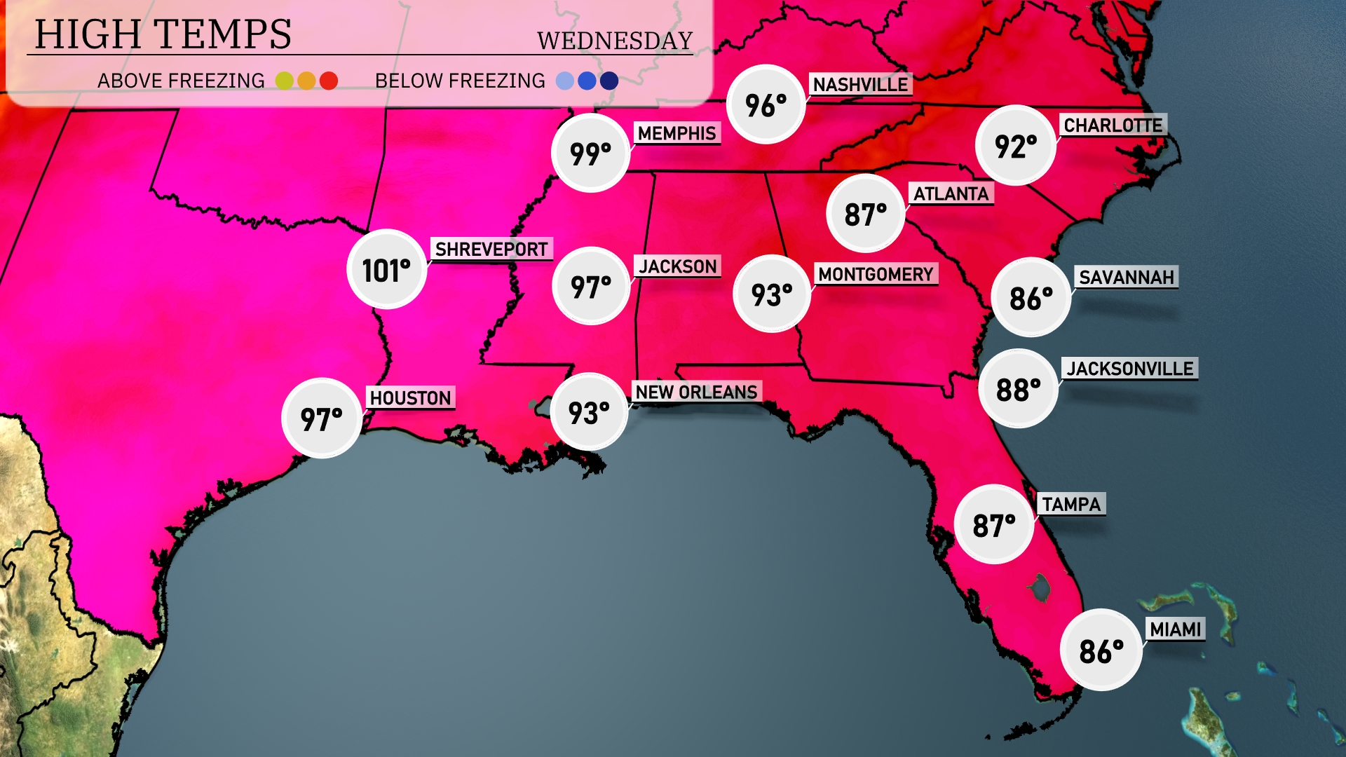
Tomorrow, Shreveport will experience a sizzling high of 101 degrees. Houston sees a warm 97 degrees, while New Orleans and Jackson will both have highs of 93 and 97 degrees, respectively. Atlanta will be slightly cooler at 92 degrees, with Montgomery reaching 87 degrees. Further east, Jacksonville and Tampa will see even more comfortable temperatures, hovering around 88 and 87 degrees. Overall, most areas in the Southeast are slightly above average for this time of year, so stay cool and hydrated!
A significant weather system is poised to impact the Southeast. Starting Tuesday evening, a cold front from the west targets areas from Houston to Birmingham, initiating scattered thunderstorms. Heavy rainfall is expected from Atlanta to Savannah by Wednesday morning, with some regions seeing up to an inch of precipitation, raising flooding concerns. Additionally, gusty winds accompany the storms, especially in parts of Georgia and Florida. Temperatures will drop post-frontal passage, bringing cooler conditions by midweek.
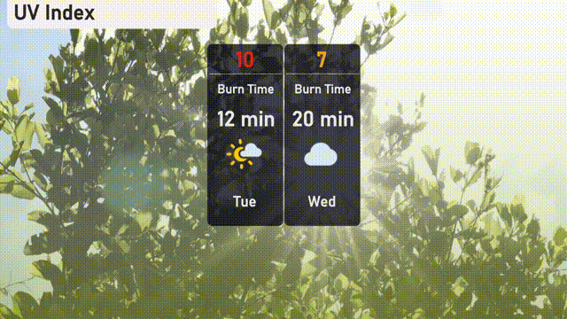
For Tuesday in Atlanta, the UV index is at a very high level of 10, with a potential sunburn occurring in just 12 minutes under the direct sun. On Wednesday, the forecast shows a lower index of 7 due to cloud cover, yet still a high level, with a burn time of around 20 minutes.
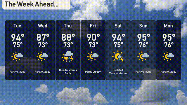
For the 7-day outlook in Atlanta:
Tuesday: Partly cloudy skies with temperatures reaching up to 94 degrees and a low of 75 degrees.
Wednesday: Expect partly cloudy conditions with a high of 87 degrees and a nighttime low near 73 degrees.
Thursday: Thunderstorms are likely early in the day, with the mercury rising to 88 degrees and a low of 73 degrees.
Friday: Partly cloudy, as temperatures peak at 90 degrees, with the low staying around 73 degrees.
Saturday: Isolated thunderstorms are possible, with a high of 94 degrees and a low of 75 degrees.
Sunday: The day will see a mix of clouds and sun, with temperatures climbing to 95 degrees and falling to 76 degrees overnight.
Monday: Partly cloudy once more with a high of 95 degrees and a low of 76 degrees.