Atlanta’s Week in Weather: From Sunshine to Storm Alerts
By
Amy Freeze
Discover what the weather holds for Atlanta this week, from balmy days to stormy evenings, and how to prepare for fluctuating conditions.
This week in Atlanta, temperatures will vary with a high of 96°F and thunderstorms expected mid-week. Stay prepared with our detailed daily analysis.
Dive into our detailed weekly forecast for Atlanta. From the scorcher days reaching up to 96°F to expected thunderstorms bringing necessary relief, we’ll break down what each day holds. Plus, tips on staying safe under the high UV index. Follow our daily updates and stay weather-wise!
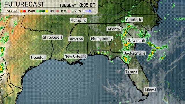
Rain showers are currently blanketing parts of northern Florida, with heavier pockets concentrated around Jacksonville. Thunderstorms are active south of Jacksonville, with these storms pushing eastward towards the Atlantic coast. The Gulf Coast cities, including New Orleans and Houston, are enjoying clear skies this morning, while Charlotte experiences a mostly cloudy day with a few scattered showers. Meanwhile, Atlanta and Montgomery remain dry under cloudy skies
Tomorrow morning in Atlanta, temperatures start at 76 degrees at 8 AM with mostly cloudy skies. A gentle east-northeast breeze blows at 8 mph, becoming slightly stronger by mid-morning. By 10 AM, the temperature rises to 80 degrees under cloudy skies with winds at 9 mph. A few showers are expected around noon as temperatures reach 83 degrees with east winds at 9 mph.
Tomorrow, high temperatures in the Southeast will be notably warm. Memphis is set to reach 99 degrees, while Nashville can expect a high of 96. In Jackson, Mississippi, the temperature will climb to 97 degrees, and New Orleans will hit 93. Atlanta will see highs around 92, slightly above average, and Montgomery is expected to reach 87 degrees. The region is influenced by a persistent ridge of high pressure, contributing to these above-average temperatures.
A cold front is advancing eastward across the Southeast, bringing with it a line of thunderstorms moving from Mississippi through Alabama by the afternoon. Expect heavy rain, especially around Atlanta, with localized flooding possible due to intense downpours. Strong storms will impact areas from Savannah to Jacksonville overnight, where gusty winds will accompany the rain. Temperatures will drop slightly post-front passage, offering relief from the recent heat.
Atlanta’s UV index today is extremely high at 10, with a burn time of just 12 minutes under direct sunlight. Make sure to limit exposure and use sunscreen liberally! By Wednesday, the UV index drops to 7, giving a bit more leniency with a burn time of about 20 minutes—still important to stay sun-smart with protection.
For the 7 Day Outlook in Atlanta:
Tuesday: Partly cloudy skies with a high of 95 degrees and a low of 75 degrees.
Wednesday: Expect scattered thunderstorms with temperatures reaching a high of 87 degrees and a low of 73 degrees.
Thursday: Thunderstorms early in the day with a high of 89 degrees and a low of 73 degrees.
Friday: Partly cloudy conditions continue, with the temperature rising to a high of 91 degrees and a low of 73 degrees.
Saturday: Isolated thunderstorms possible as temperatures peak at 93 degrees and drop to 75 degrees during the night.
Sunday: Partly cloudy, reaching up to a warm 95 degrees and cooling to 76 degrees in the evening.
Monday: Wrap up the week with partly cloudy skies and a high of 96 degrees, paired with a low of 73 degrees.