Miami’s Magic and Mayhem: Sunshine Today, Thunderstorms Tomorrow
By
Amy Freeze
A rollercoaster of weather awaits in Miami and the Southeast as sunny skies trade places with upcoming thunderstorms. Here’s your in-depth forecast, served sunny-side up!
Today in Miami: delightful sunshine with temps up to 88°F. Changes loom as a formidable cold front brings thunderstorms by Thursday. Brace for impactful weather!
This sunny afternoon in Miami holds a hint of the dramatic turn ahead. The region braces for a dynamic weather shift, with a cold front ushering in thunderstorms and cooler temperatures across the Southeast. Expect highs of 88°F today before thunderous changes blast through. For detailed hourly transitions and how this affects your area, visit https://amyfreeze.ai/
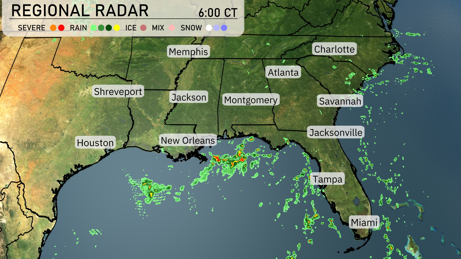
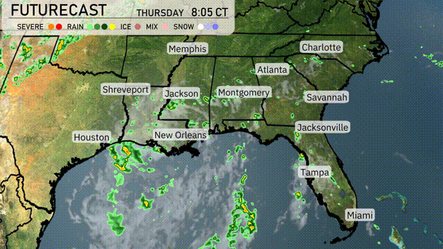
The Regional Radar for the Southeast shows scattered rain and thunderstorms moving through the Gulf Coast, from New Orleans to Pensacola. There are clusters of moderate to heavy showers near New Orleans and extending along the southern Mississippi coast. Cloud cover is building over Montgomery and Atlanta as the rain approaches from the southwest. Meanwhile, scattered precipitation dots the landscape near Jacksonville, indicating spotty showers likely.
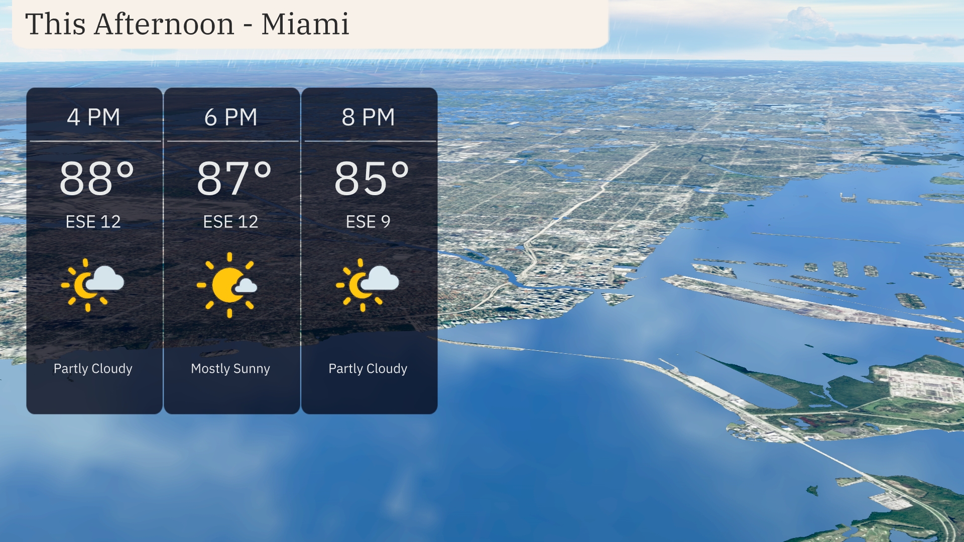
Through this afternoon in Miami, temperatures are climbing into the upper 80s with an east-southeast wind at 12 miles per hour. Skies will be partly cloudy, providing a mix of sun and shade. Most of the afternoon will hover around 88 degrees at 4 PM and settling to 85 degrees by 8 PM. Expect a mostly sunny outlook around 6 PM, drawing down to partly cloudy conditions by evening.
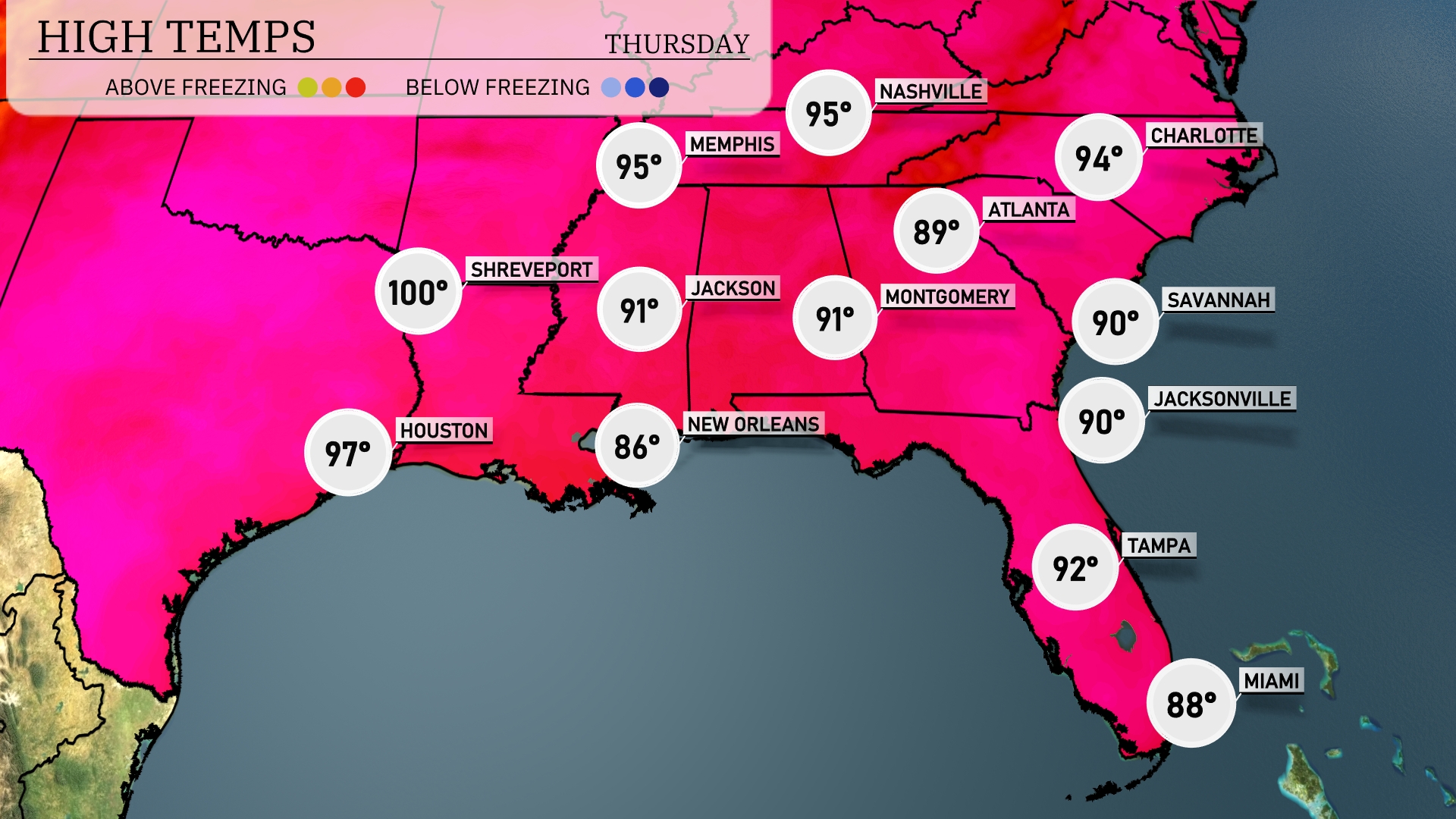
Today’s high temperatures in the Southeast are sizzling. Shreveport leads the charge with a scorching 100 degrees, while Houston isn’t far behind at 97. Atlanta feels the heat, reaching 94, with Montgomery and Jackson both hitting 91. The temperatures remain more moderate in coastal areas, with Tampa seeing a high of 92 and Miami a cooler 88.
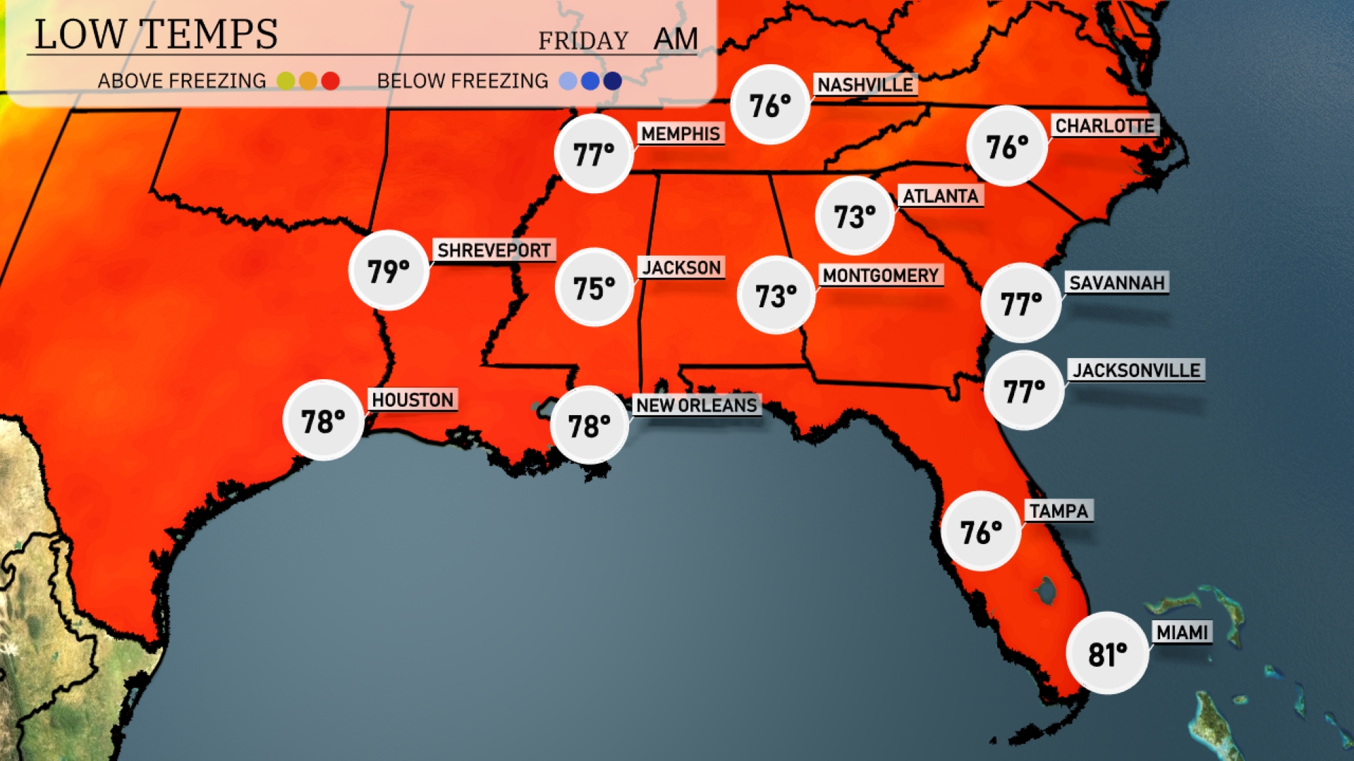
Tonight, Memphis will cool down to 76 degrees, while Nashville expects a low of 73. In Jackson, temperatures will drop to 75, contrasting with Shreveport’s warmer low of 79. Atlanta will see a mild night with a low of 73, and further south, Miami will be comfortable at 81 degrees.
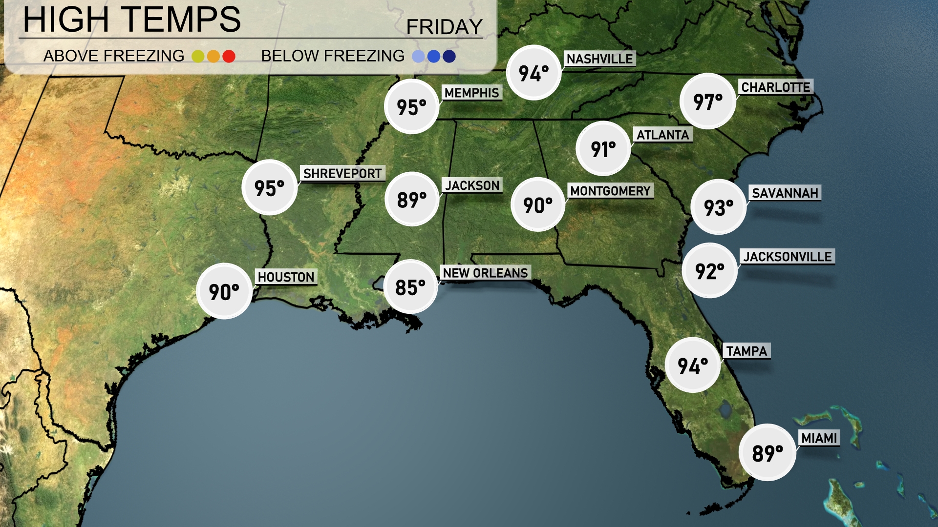
Tomorrow, temperatures in the Southeast will soar with Memphis hitting 95 degrees, closely followed by Nashville at 94 degrees. In Mississippi, Jackson is expected to reach 89 degrees and New Orleans will see a high of 85 degrees. Over in Florida, expect a warm day with Tampa at 94 degrees and Jacksonville hitting 92 degrees. Meanwhile, Savannah is projected to be the hottest spot in the region at a sweltering 93 degrees, a trend reflecting above-average temperatures spurred by a high-pressure system in the area.
A cold front is sweeping across the Southeast, bringing thunderstorms from Texas to Alabama. Expect showers in New Orleans early Thursday, with widespread rain reaching Montgomery by afternoon. Jacksonville to Savannah sees storms developing late in the day. Houston should brace for heavy rain in the morning with potential for flash flooding. As the front progresses, expect cooler and clearer skies by Friday.
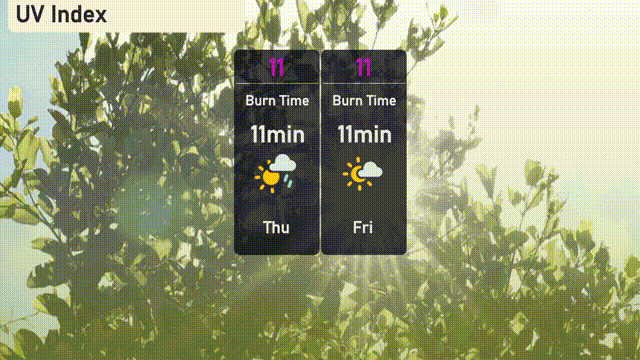
The UV index for Miami is extremely high on Thursday and Friday, reaching a level of 11, which means the sun’s rays are very intense. Expect a burn time of just 11 minutes when exposed directly without protection, so it’s crucial to wear sunscreen and cover up if you’re planning to be outdoors. Stay safe and plan sun activities accordingly!