Chicago’s Weather Whirlwind: Sunny Days and Stormy Nights
By
Amy Freeze
Experience the fluctuating weather conditions in Chicago, from balmy afternoons to storm-laden evenings, complete with comprehensive daily forecasts.
This week in Chicago, prepare for an ever-changing skyline with partly cloudy to stormy conditions. See how each day unfolds weather-wise in the city!
Chicago Evening News – 07/27/2025 – This week, Chicago transitions from warm sunny scenes to occasional stormy flares. Each day brings a different aspect of nature, showcasing varying temperatures and conditions including potential sun exposure risks. From UV index warnings to storm precautions, stay informed and safe as the weather evolves. Dive deeper into each day’s specifics with our full report.
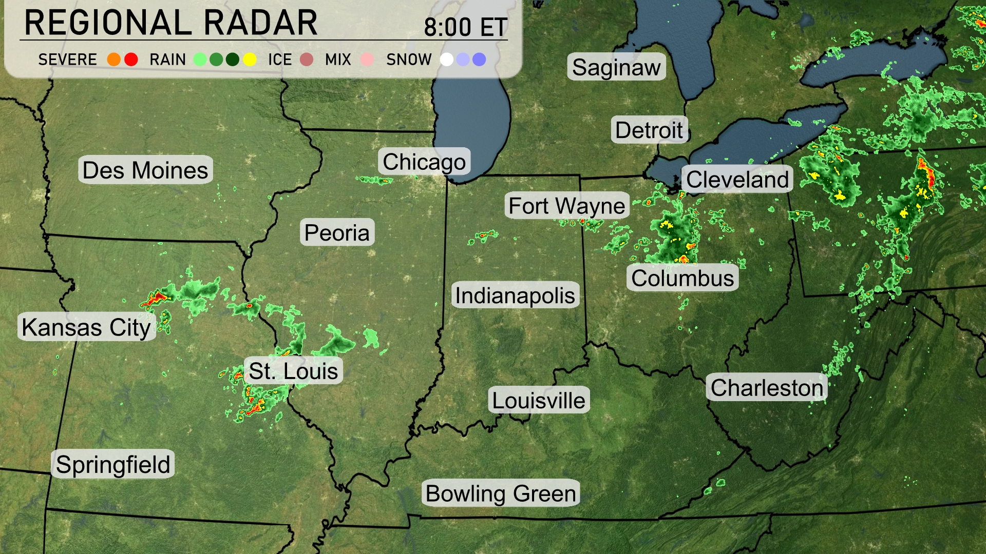
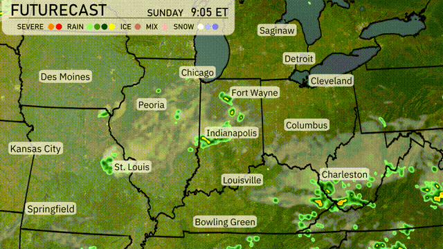
A dynamic weather pattern is unfolding in the Midwest, with storm systems affecting several areas. Strong storms are progressing from Kansas City towards St. Louis, marked by severe weather activity on the radar. Columbus is experiencing rain showers with some mixed precipitation pushing northeast towards Cleveland. Meanwhile, parts of Michigan, including Detroit, are observing light scattered showers, while Bowling Green remains relatively clear this morning.
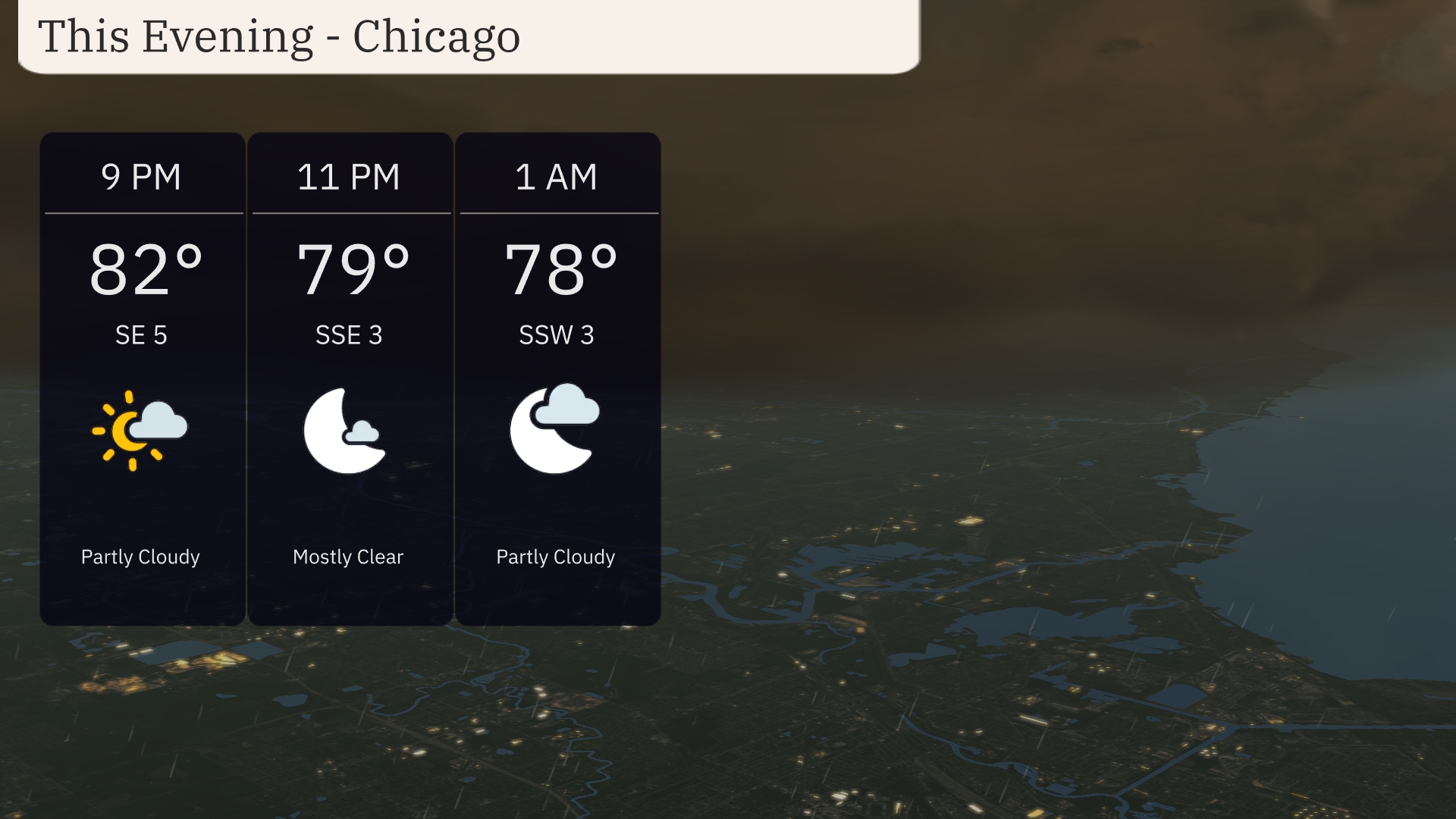
For this evening in Chicago, temperatures will start at 82 degrees at 9 PM, dropping slightly to 78 degrees by 1 AM. The sky will be partly cloudy, transitioning to mostly clear conditions around 11 PM. Winds will be light, starting from the southeast at 5 mph, shifting to south-southeast at 3 mph.
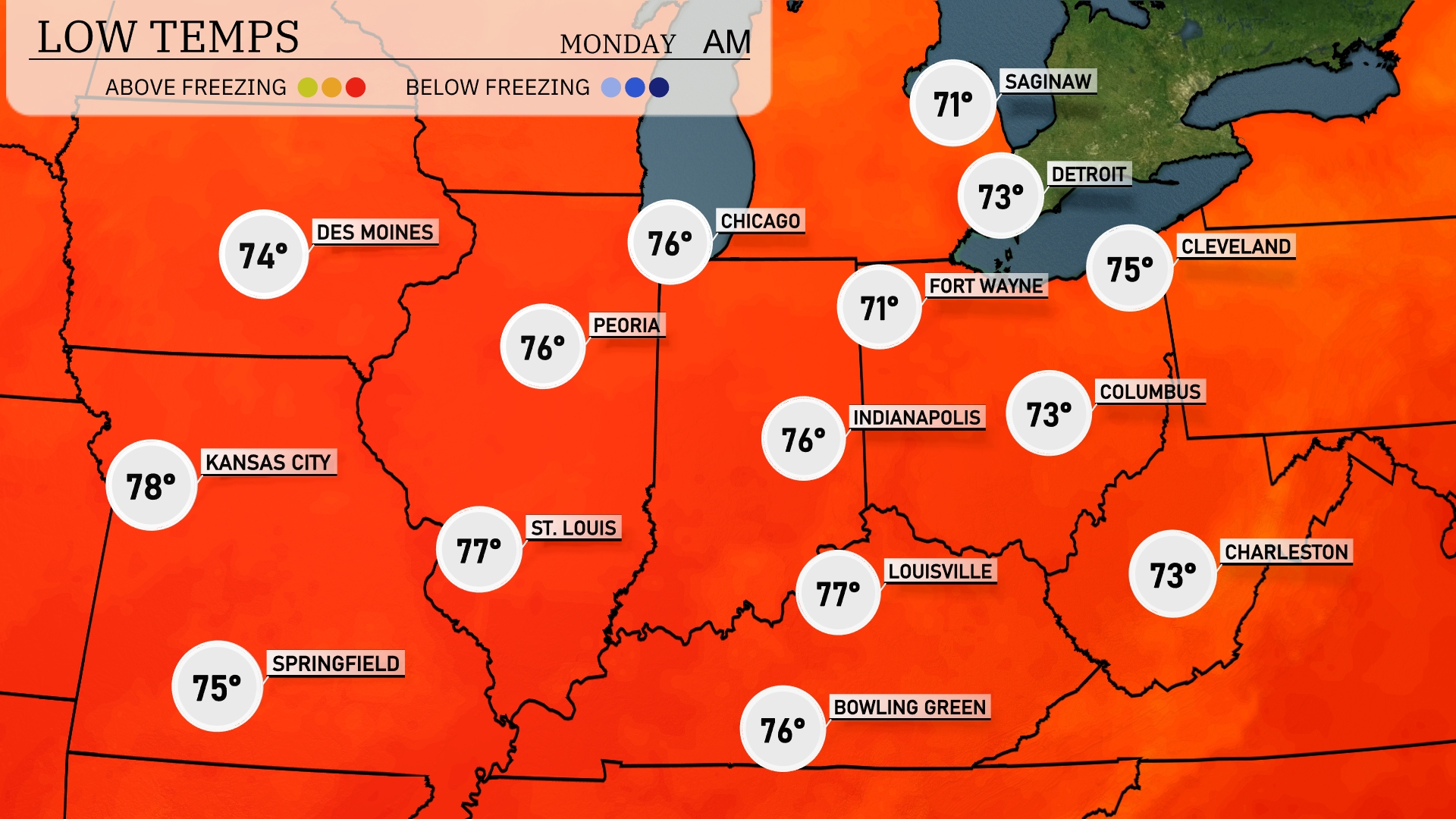
Tonight in the Midwest, Chicago will cool down to 76 degrees, while Indianapolis sees a low of 76 as well. Fort Wayne is expected to drop to 73, with Cleveland slightly cooler at 75 degrees. Expect Kansas City to remain warm at 78, while St. Louis also stays mild at 77 degrees.
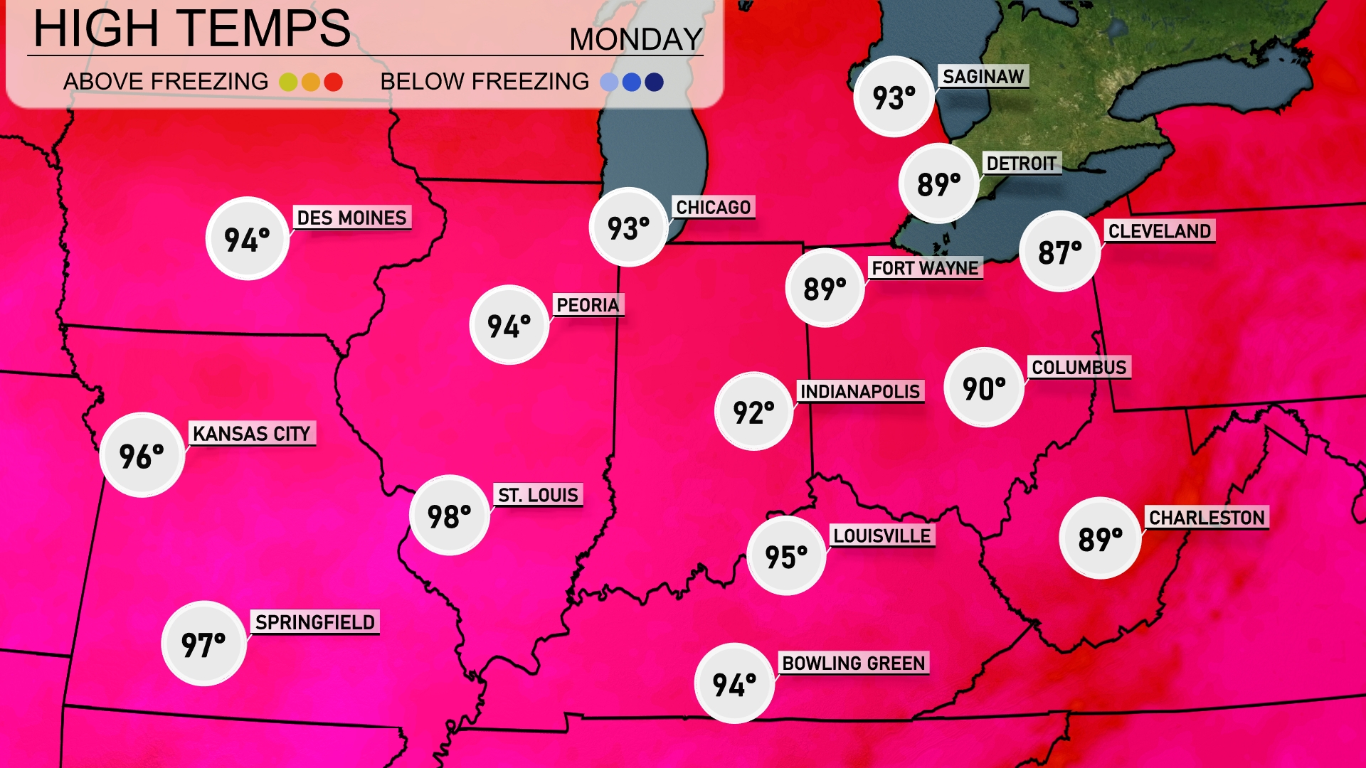
Tomorrow, the Midwest will experience significant warmth with several cities reaching above-average highs. Chicago is expected to hit 93 degrees, while Des Moines will also see a high of 94. Kansas City is forecasted to soar to 96 degrees, with St. Louis even warmer at 98. Indianapolis will reach 92 degrees, and Louisville is looking at a high of 95. These elevated temperatures come as a result of sustained high-pressure, leading to clear skies and increasing humidity.
A warm front pushing through the Midwest will bring scattered showers and thunderstorms from Peoria to Cleveland, primarily during the afternoon and evening hours. Expect brief heavy downpours and isolated strong storms, particularly around Louisville and Bowling Green. Temperatures will remain warm and humid ahead of the front, with a cooler air mass setting in as it passes. Be prepared for possible localized flooding due to heavy rainfall, especially in low-lying areas. The Midwest clears out by Monday afternoon, with cooler, drier conditions settling in from Chicago to St. Louis.
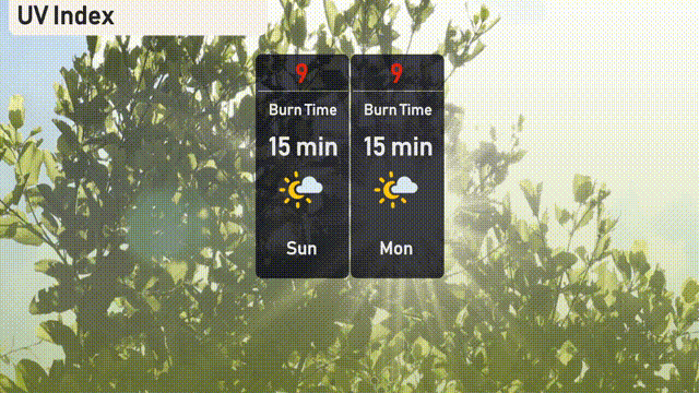
The UV index in Chicago is at 9 for both today and tomorrow, indicating very high sun exposure risk with a burn time of just 15 minutes. Make sure to use high SPF sunscreen, seek shade, and wear protective clothing if outdoors. Stay sun-smart while enjoying your activities.
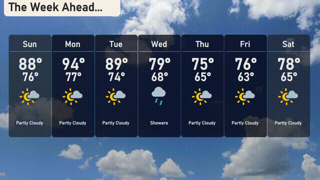
For the 7 day forecast in Chicago:
Sunday: Partly cloudy skies with a high of 88 degrees and a low of 76 degrees.
Monday: Mostly sunny with temperatures climbing to 94 degrees and dropping to 77 degrees at night.
Tuesday: Another warm day, reaching 89 degrees for the high and 74 for the low.
Wednesday: Showers are expected with a high of 79 degrees and a low of 68 degrees.
Thursday: Cooler, with a mix of sun and clouds, hitting a high of 75 degrees and a low of 65 degrees.
Friday: Partly sunny skies continue with a high of 76 degrees and a low of 63 degrees.
Saturday: Partly cloudy, warming up slightly to 78 degrees during the day and 65 degrees overnight.
Stay prepared for the changing weather, and enjoy your week!