Temperatures and Tempests: A Detailed Look at the Southwest’s Dynamic Weather
By
Amy Freeze
From sizzling highs to refreshing breezes, explore a comprehensive update on the weather trends sweeping through the Southwest.
Catch updates on current weather conditions across the Southwest. From Salt Lake City’s evening showers to the blazing sun in Phoenix, explore how the weather impacts your day.
This week, the Southwest sees a diverse range of weather phenomena. Salt Lake City experiences a mix of cloudy skies and showers, while Phoenix battles extreme heat. Dive deep into our blog for details on each city, along with a seven-day weather outlook and safety tips for handling high UV indexes. Stay informed with our comprehensive coverage.
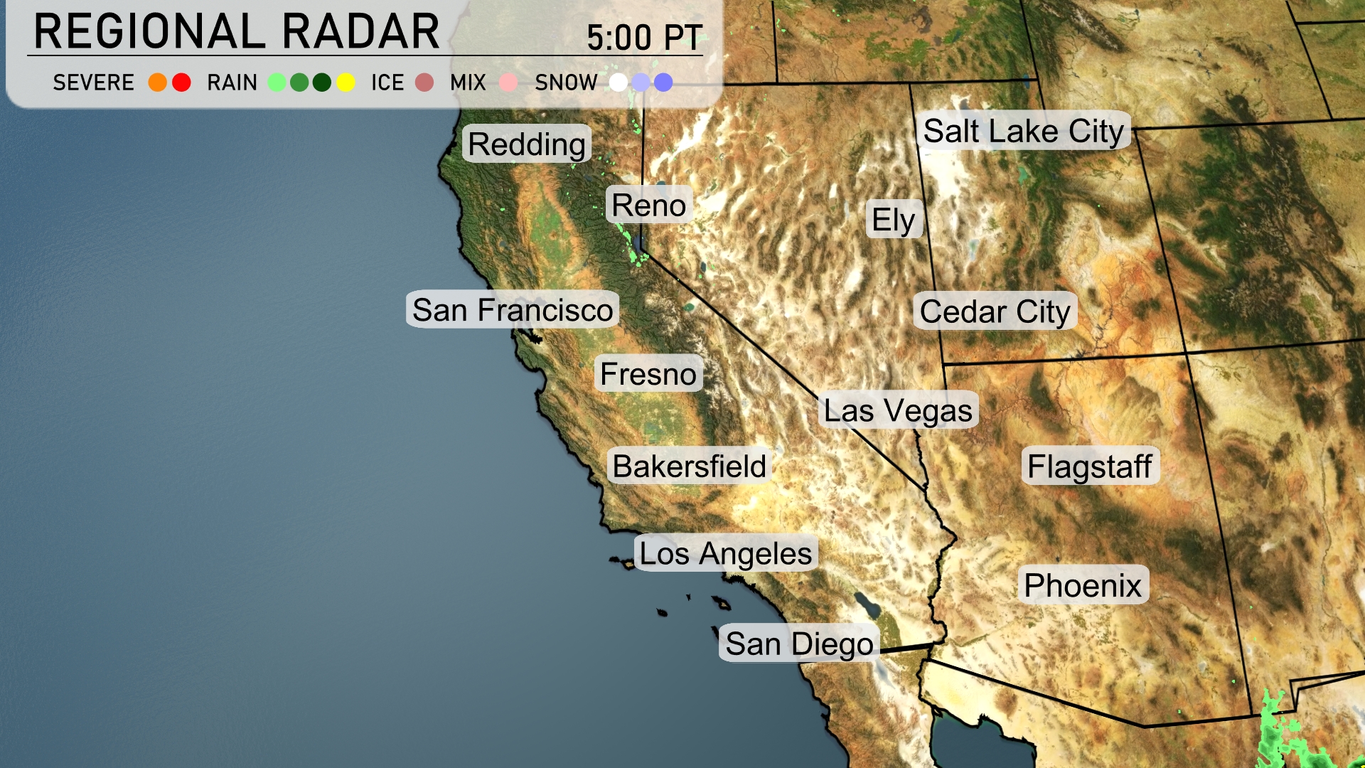
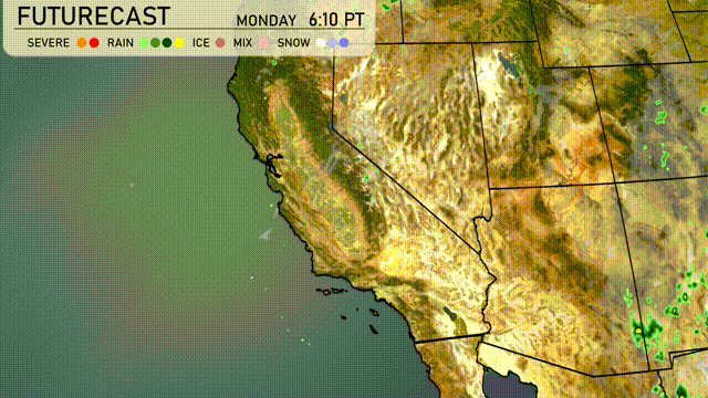
The Southwest region is currently experiencing a mix of weather conditions. Light showers are expected along the coastline near San Diego and Los Angeles, providing relief from dry conditions. Flagstaff is likely to see some cloud cover with cool temperatures, while Las Vegas remains dry. Snow is visible near Salt Lake City, indicating cooler conditions in the region.
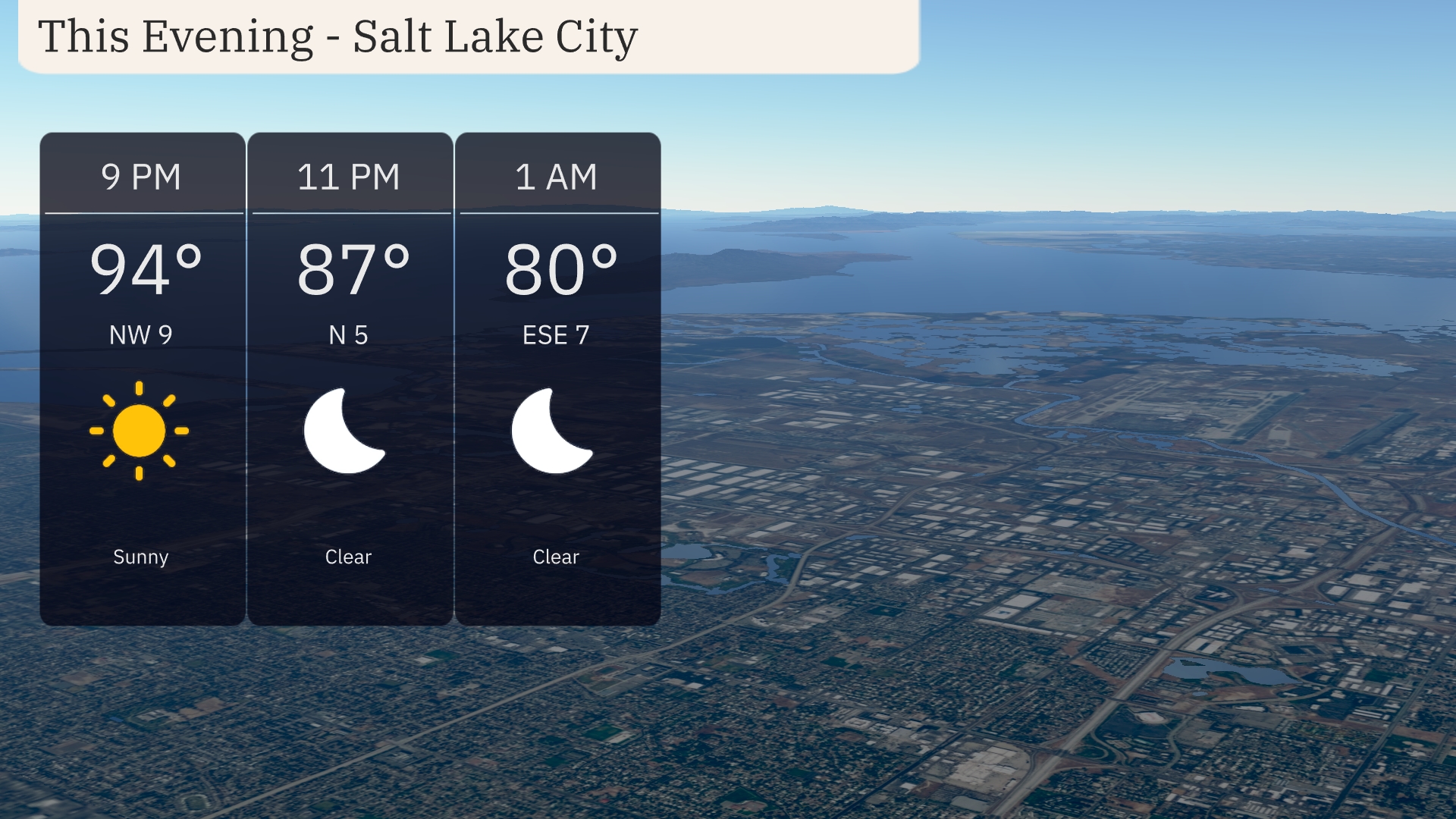
This evening in Salt Lake City, clear skies will prevail as temperatures gradually fall from 94 degrees at 9 PM to 80 degrees by 1 AM. A northwesterly breeze at 9 miles per hour will ease to a gentle easterly wind of 7 miles per hour overnight.
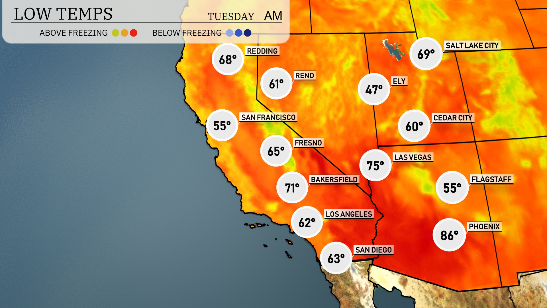
Tonight, look for temperatures to drop to 55 degrees in San Francisco and Flagstaff. Bakersfield will see a low of 71, while Los Angeles cools down to 62. In the desert, Las Vegas remains warmer at 75, but Ely will feel a significant chill at 47 degrees.
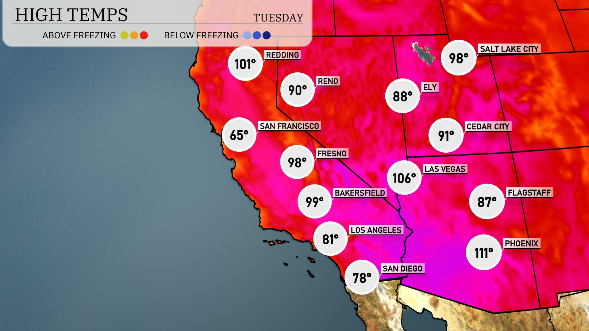
Tomorrow in the Southwest, Phoenix is set for a scorching high of 111 degrees, while Las Vegas will reach a sizzling 106 degrees. Bakersfield is expected to see temperatures climb to 99 degrees, making it a hot day across the region. In contrast, San Francisco enjoys a cooler 65 degrees, significantly below the typical temperatures for this time of year.
A developing weather pattern brings thunderstorms across southern Arizona and New Mexico starting overnight through Tuesday. Expect heavy rain and gusty winds, with possible isolated severe storms in eastern areas. Temperatures will remain warm, with highs reaching into the 90s for most of the Southwest. However, a cold front will push through by late Tuesday, which could lower temperatures slightly by Wednesday.
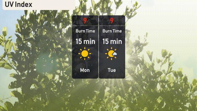
The UV index in Salt Lake City will be very high at 9 on both Monday and Tuesday, leading to a burn time of approximately 15 minutes. Remember to wear sunscreen, hats, and sunglasses if you’ll be outdoors.
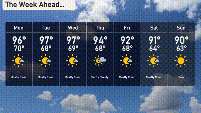
Here’s the 7 day outlook for Salt Lake City:
Monday brings mostly clear skies with a high of 96 degrees and a low around 70 degrees.
Tuesday remains mostly clear as well, with temperatures peaking at 97 degrees and dipping to 68 degrees overnight.
Wednesday continues with mostly clear conditions, reaching a high of 97 degrees and a low of 69 degrees.
Thursday sees partly cloudy skies and a slight cool down, with a high of 94 degrees and a low of 68 degrees.
Friday will be mostly clear again, with a high of 92 degrees and an overnight low of 68 degrees.
Saturday keeps it mostly clear, but temperatures ease down slightly to a high of 91 degrees and a low of 64 degrees.
Sunday concludes the week with clear skies, reaching a high of 90 degrees and dropping to 63 degrees by night.