Brace yourself for a mix of sun and clouds, with increasing showers. Get the full Southeast weather forecast including storm warnings and temperature spikes.
Facing a stormy start in Atlanta with thunderstorms predicted in the morning and temperatures steadily rising. Learn more about how this could affect your week.
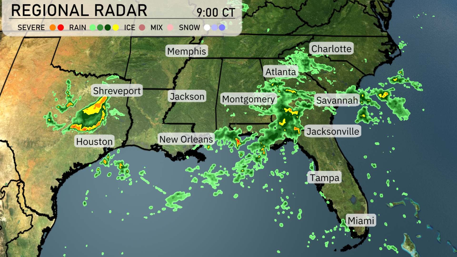
The Southeast unfolds under an active weather pattern, marked by a robust line of storms impacting a broad stretch from Shreveport to Houston. Learn how Atlanta will experience this stormy trend with early thunderstorms, and what the incoming warm front means for your local climate. Detailed insights on overnight temperatures and a 7-day forecast await your interest. Dive deeper into the implications of this weather system at https://amyfreeze.ai/.
A robust line of storms is currently impacting areas from Shreveport to Houston with heavy rain and severe weather warnings in place. Further east, Jackson is experiencing moderate rainfall moving towards Alabama. Atlanta is seeing an increase in showers as the storm stretches its reach towards the Carolinas, bringing dense cloud cover and rain to Savannah and Charleston. In the meanwhile, the coastal regions from New Orleans to Jacksonville are enveloped in scattered showers, keeping the Southeast quite active weather-wise.
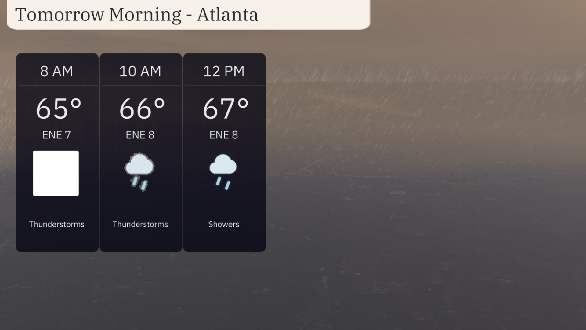
For tomorrow morning in Atlanta, you can expect thunderstorms early with the temperature starting at 65 degrees. Winds will be from the east-northeast at 7 mph. As the morning progresses, temperatures will rise slightly to 66 degrees by 10 AM, continuing with thunderstorms and winds picking up to 8 mph. By noon, the temperature is forecasted to reach 67 degrees with showers persisting.
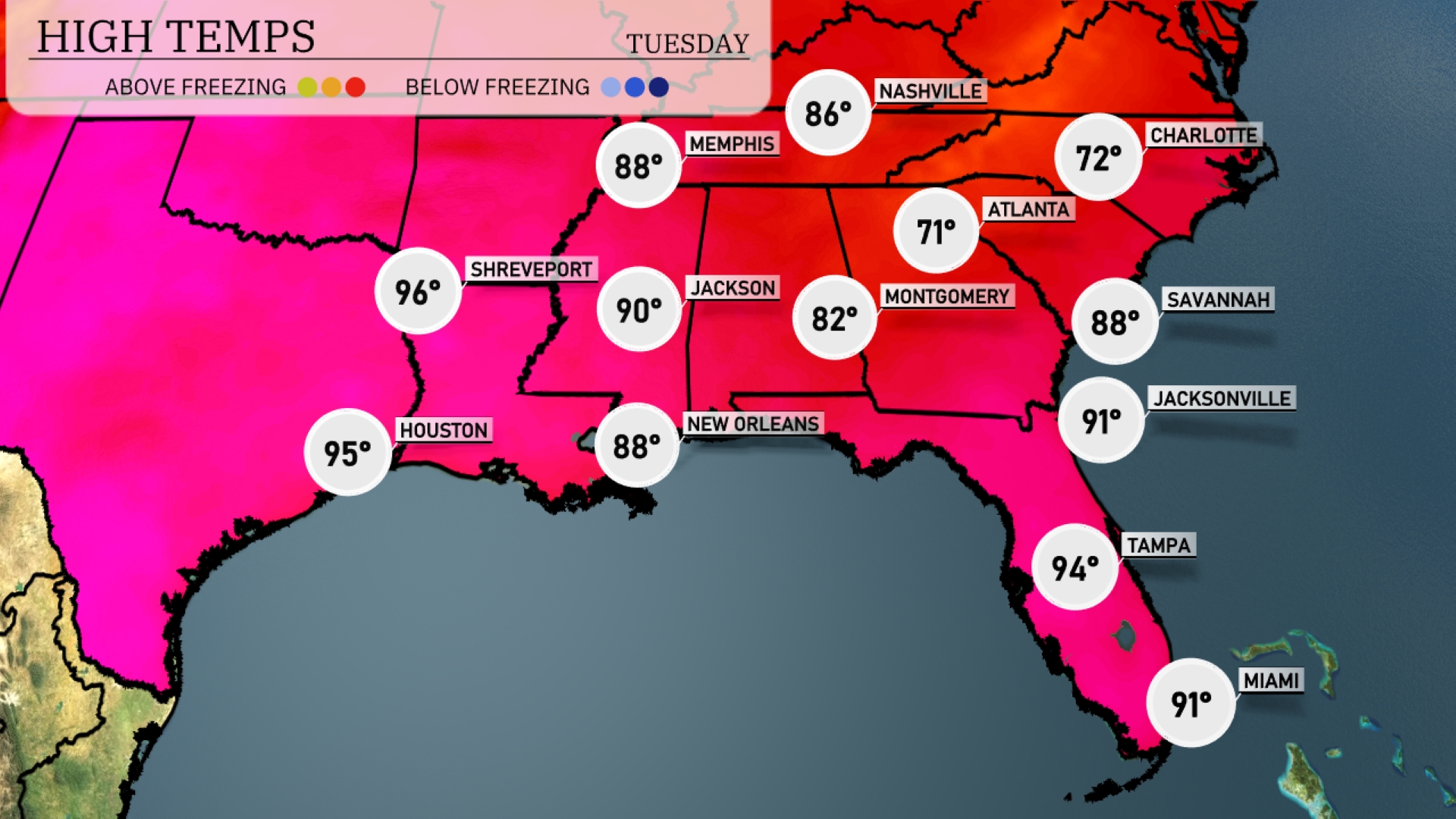
Tomorrow in the Southeast, highs will soar with Shreveport reaching 96 degrees. Houston isn’t far behind, expected to hit 95 degrees. Jacksonville will be toasty at 91 degrees, while Tampa will see a high of 94. New Orleans is forecasted to warm up to 88 degrees, and Memphis will experience slightly cooler temperatures at 88 as well.
A warm front is advancing into the Southeast, bringing showers and thunderstorms from New Orleans to Jacksonville on Wednesday. Expect scattered storms in Atlanta with potential for localized heavy rainfall, possibly leading to flash flooding—so keep an eye on low-lying areas. Temperature-wise, it’ll remain warm and humid, with highs lingering in the mid-80s. Keep an umbrella handy in Charlotte as showers roll through by late afternoon, tapering off by nightfall.
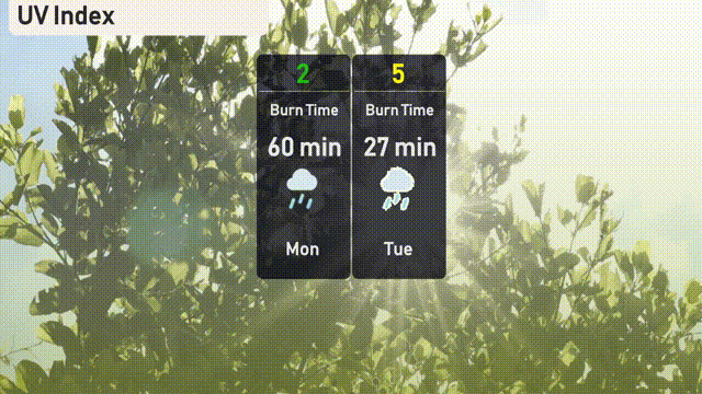
The UV index in Atlanta starts with a low of 2 on Monday, with storms keeping the UV exposure minimal and reducing any sunburn risk. By Tuesday, it rises to 5, leading to a moderate burn time of about 27 minutes in direct sunlight.
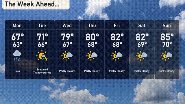
For the 7-day outlook in Atlanta:
Monday: Expect rain with a high of 67 degrees and a low of 63.
Tuesday: Scattered thunderstorms with a high of 71 degrees, cooling down to 66 at night.
Wednesday: Partly cloudy with temperatures reaching up to 79 degrees and a nighttime low of 67.
Thursday: Partly cloudy skies continue with a high of 80 degrees and a low of 68.
Friday: Enjoy partly cloudy conditions, the temperature climbing to 82 degrees, and dipping to 68 at night.
Saturday: Another partly cloudy day with a high around 82 degrees and an overnight low of 69.
Sunday: Partly cloudy with a warming trend, as temperatures rise to 85 degrees and settle at 70 degrees overnight.