Chasing Clouds in Atlanta: Tomorrow’s Weather Forecast and Beyond
By
Amy Freeze
Explore tomorrow morning's weather for Atlanta and the dramatic shifts across the Southeast from sunny spells to stormy horizons.
Get ready for a mix of clouds and light showers in Atlanta tomorrow morning with temps starting at 75°F. Expect a warm up and potential storms as the week progresses!
Tomorrow starts with partly cloudy skies in Atlanta and light to moderate showers across the Southeast. As the day progresses, temperatures will rise with some regions hitting the mid-90s. Our eyes are on a cold front moving in, bringing potential stormy weather and a significant drop in temperatures later in the week. Stay tuned for updates on storm risks and safety precautions!
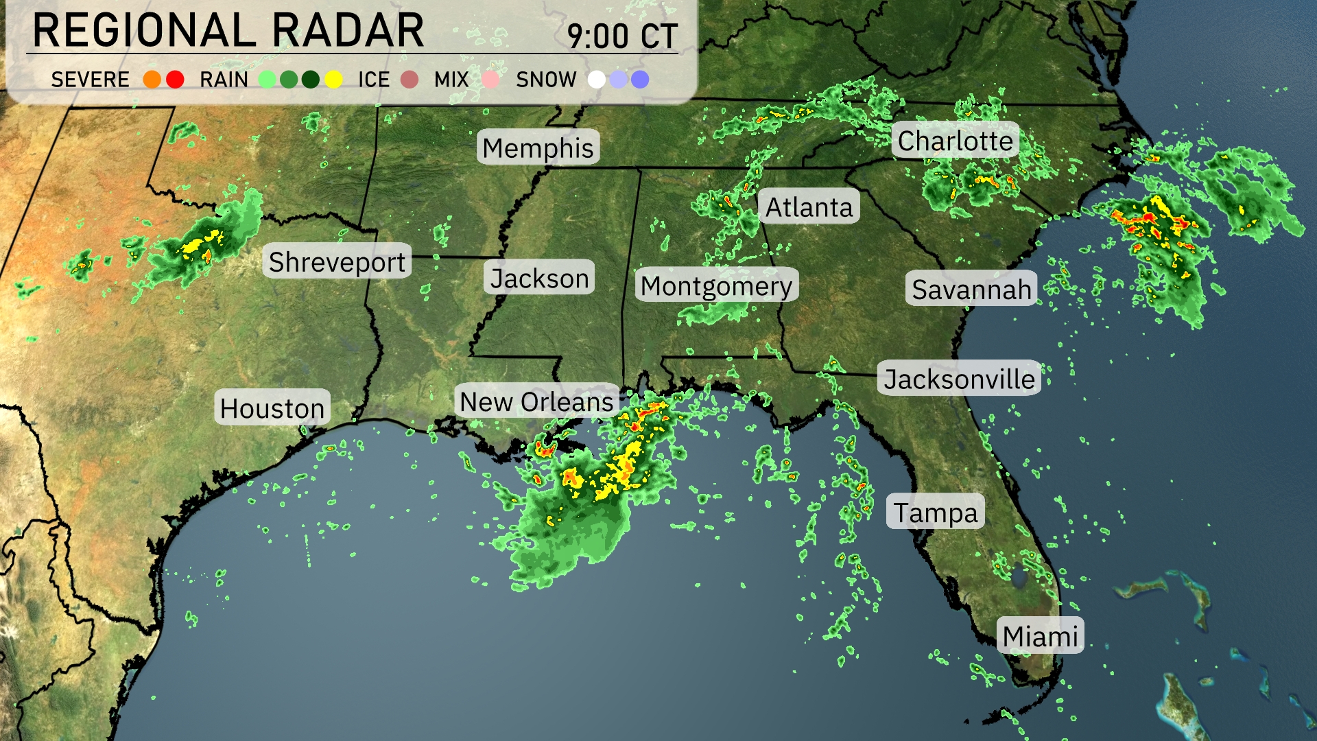
A line of rain is stretching from New Orleans northward toward Jackson, bringing moderate showers through these areas. Meanwhile, another band of rain extends from Nashville eastward towards the Carolinas, brushing cities like Charlotte and Atlanta with light to moderate showers. Scattered storms are skirting the Gulf Coast, impacting places such as Mobile and potentially reaching into the Florida Panhandle. Farther east, Savannah and Charleston are experiencing heavier rain showers as the system progresses into the Atlantic.
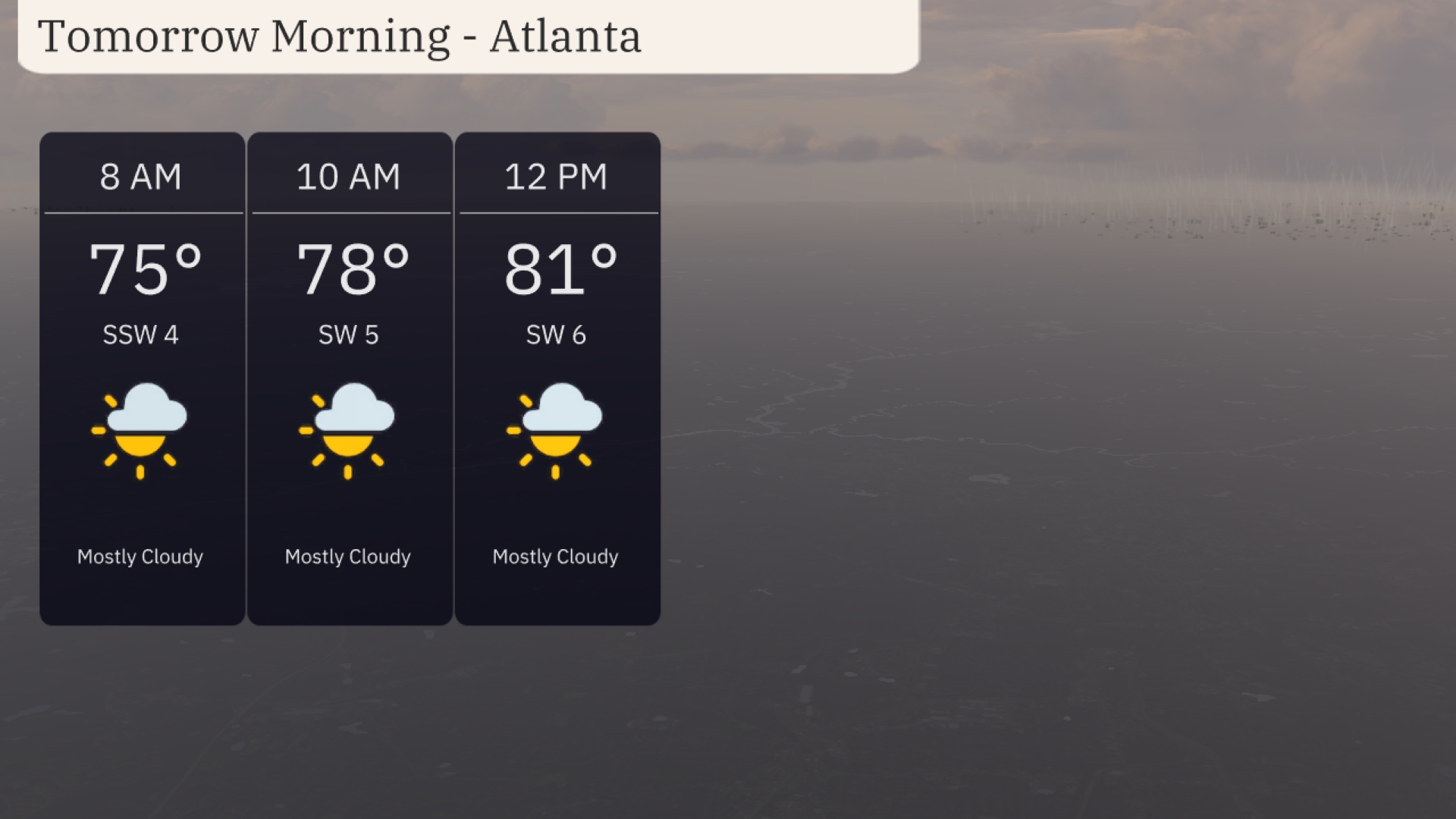
Tomorrow morning in Atlanta, expect mostly cloudy skies with temperatures starting at 75 degrees at 8 AM. The temperature will rise slightly to 78 degrees by 10 AM and continue to 81 degrees by noon. Winds will be coming from the southwest at 4 to 6 miles per hour through the morning.
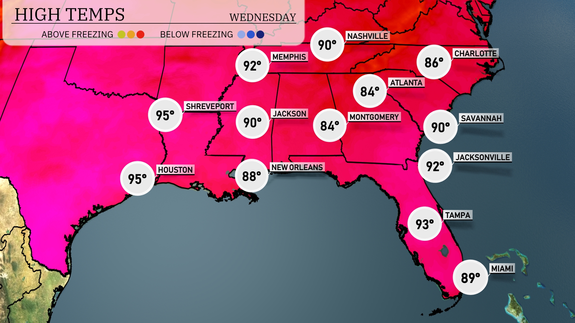
Tomorrow in the Southeast, temperatures rise significantly with highs across the region. Houston and Shreveport will both reach a sizzling 95 degrees, while Jackson can expect a high of 90. Atlanta will see a comfortable 84 degrees, and Montgomery is looking at a high of 84 as well. Near the coast, Jacksonville will warm up to 92 degrees, and Tampa is forecasted to hit 93 degrees. These temperatures are well above average for this time of year.
A cold front is advancing across the Southeast, bringing a pattern shift and some stormy weather. Tuesday sees thunderstorms rolling through cities including New Orleans, Montgomery, and Jacksonville, with localized heavy downpours. Atlanta will have some storm activity by Wednesday morning, impacting the commute. Watch for potential severe weather risks in areas like Mississippi and Alabama, with the threat of damaging winds. After the front passes, cooler and drier conditions will settle in for the end of the week.
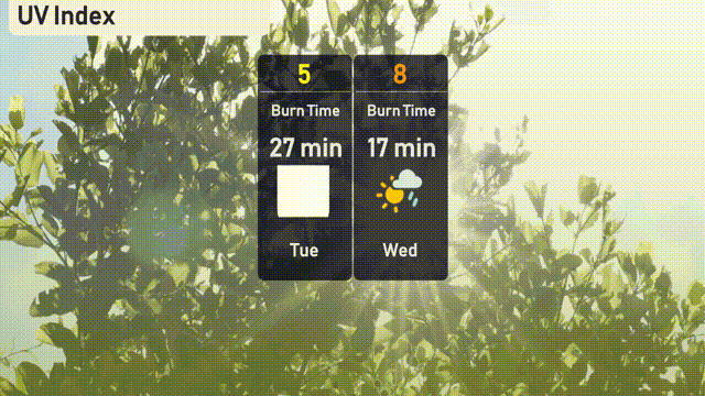
The UV index in Atlanta on Tuesday is 5, indicating moderate sun exposure with a burn time of about 27 minutes. Wednesday’s UV forecast indicates a higher level of 8, with quick burn times of approximately 17 minutes.
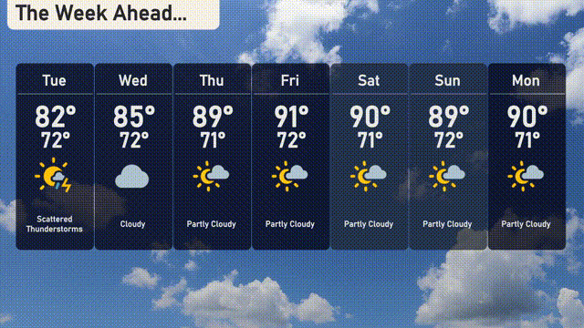
For the 7 Day Outlook in Atlanta:
Tuesday: Scattered thunderstorms with a high of 82 degrees and a low of 72 degrees.
Wednesday: Cloudy with a high of 85 degrees and a low of 72 degrees.
Thursday: Partly cloudy, temperatures reaching 89 degrees for the high and 71 degrees for the low.
Friday: The sun peeks through partly cloudy skies with highs around 91 degrees and lows at 72 degrees.
Saturday: More clouds, partly cloudy with a high of 90 degrees and a low of 71 degrees.
Sunday: Expect partly cloudy conditions again, highs hitting 89 degrees with a low of 72 degrees.
Monday: Wrapping up with partly cloudy skies, the high will be 90 degrees and the low 71 degrees.