Miami Weather Update: A Week of Sun, Showers, and Surprises
By
Amy Freeze
Explore the shifting skies of Miami with our detailed seven-day weather forecast. From balmy mornings to stormy nights, know what to expect and how to prepare.
Catch the latest on Miami’s weather: Partly cloudy mornings, stormy nights, and everything in between. Learn how this week’s conditions can affect your plans.
This week in Miami unfolds with a variety of weather patterns ranging from partly sunny mornings to potential stormy evenings. Temperatures are climbing, with humidity adding a sticky touch to the air. Midweek, anticipate possible thunderstorms that could lead to rapid changes in outdoor conditions. Stay updated with our daily posts to maximize your comfort and safety throughout each weather shift.
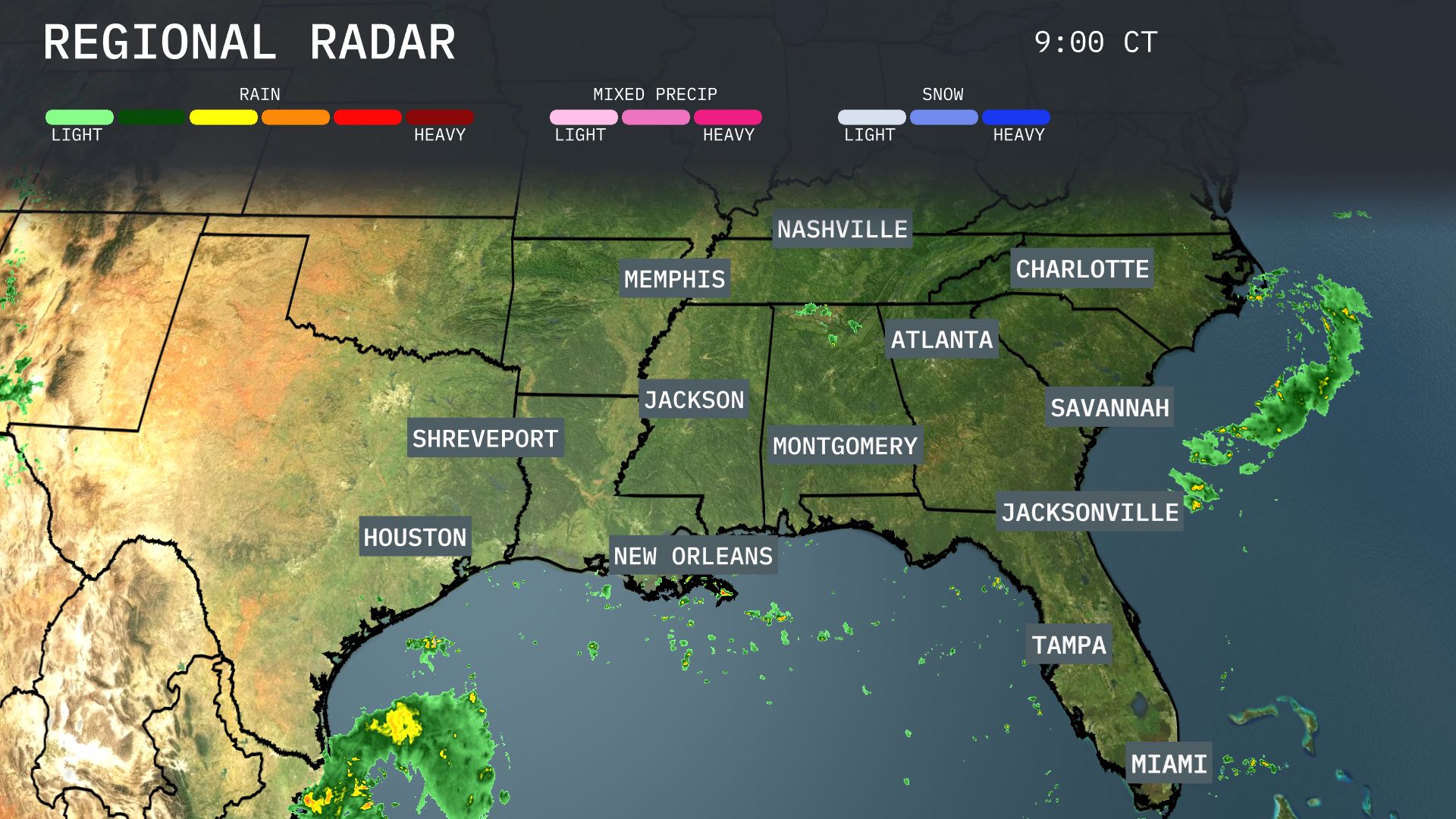
A band of rain is seen approaching the Gulf Coast, just southwest of New Orleans, bringing showers that could later affect the city. Light to moderate showers are scattered across southern Alabama, stretching toward Montgomery, and extending into western Georgia, affecting areas around Atlanta. The coastal regions of the Carolinas are seeing some Northern parts of the Southeast, like Nashville and Memphis, remain dry and clear for now.
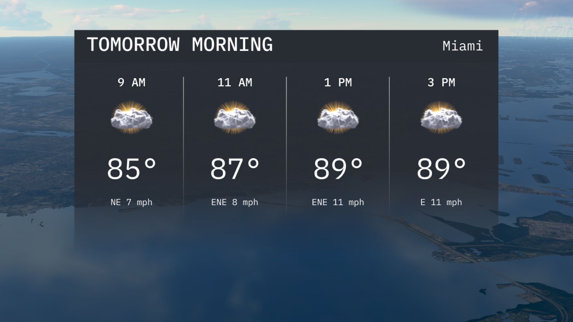
Temperatures in Miami will start at 85 degrees at 9 AM and gradually rise to 87 degrees by 11 AM. Expect partly cloudy skies with a light northeast wind, shifting to east-northeast later in the morning. This combination makes for a warm and breezy start to the day.
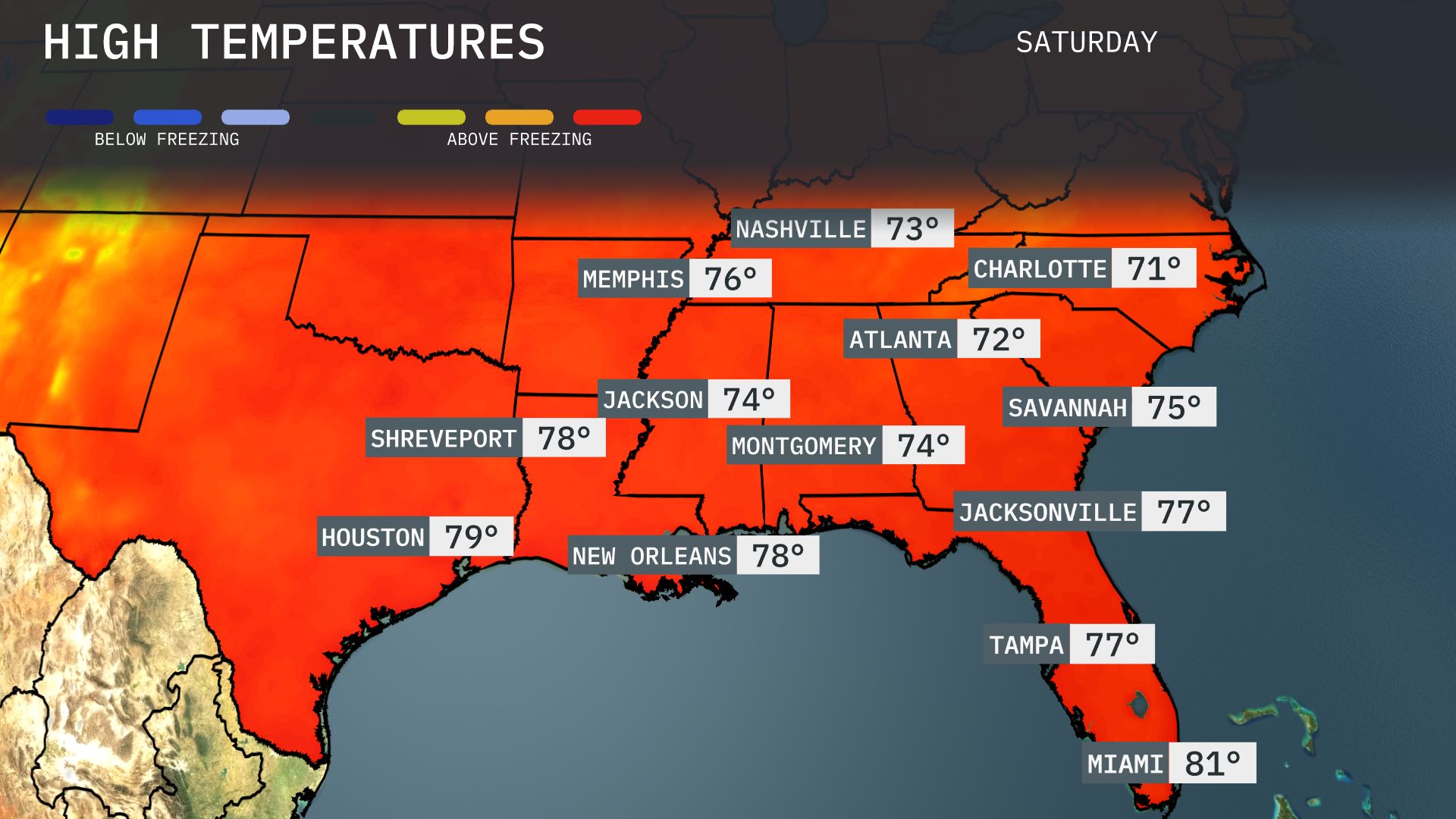
Tomorrow in the Southeast, temperatures will soar above average for this time of year. Atlanta is expected to reach a high of 72 degrees, while Memphis will warm up to 76 degrees. In New Orleans, temperatures will peak at 78 degrees, and Jacksonville follows closely at 77 degrees. Montgomery will see highs of 74 degrees, with Savannah not far behind at 75. Miami will enjoy warmer weather, hitting 81 degrees, making it the hottest spot in the region.
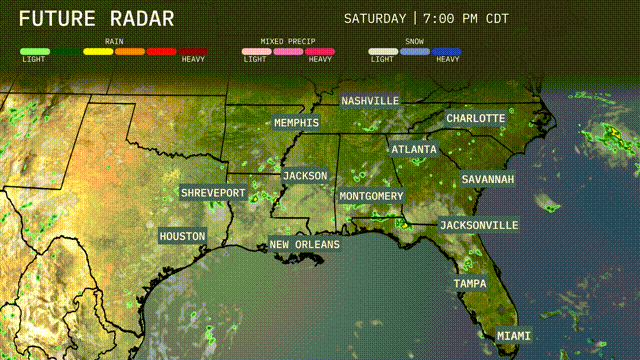
A cold front is sweeping across the Southeast, bringing showers and scattered thunderstorms from Shreveport to Nashville on Friday. Expect potential severe weather in Memphis and Jackson with gusty winds and heavy rainfall likely through the evening. As the front progresses, widespread storms are expected Saturday from Atlanta down to Miami, posing a risk for localized flooding. Prepare for temperature drops behind the front, with cooler air settling into areas like Charlotte and Savannah on Sunday. Rain will begin to clear, giving way to drier conditions by the weekend.
The UV index in Miami is high today and tomorrow, with burn times of about 11 minutes in direct sunlight.
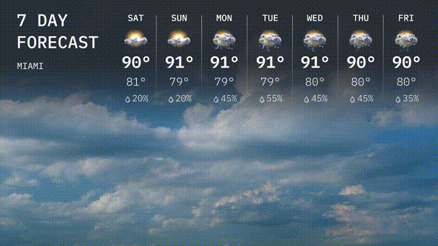
Saturday: Anticipate a high of 90 degrees with a low of 81 degrees, partly cloudy.
Sunday: It’ll stay warm at 91 degrees, low of 79 degrees and a 20 percent chance of rain.
Monday: Partly cloudy with temperatures topping out at 91 degrees, a low of 79 degrees and 45 percent chance of rain.
Tuesday: Showers expected with highs around 91 degrees and lows near 79 degrees, and rainfall chance is 55 percent.
Wednesday: Scattered thunderstorms could develop. Temperatures reach 91 degrees, with a low near 80 degrees and 45 percent rain chance.
Thursday: Keep the umbrella handy, 80 percent chance of storms, high of 90 degrees and low of 80 degrees.
Friday: Concluding the week with scattered showers, 90 degrees high, 80 degrees low, and a 35 percent chance of rain.