Navigating Through NYC’s Changing Skies: Weather Forecast for the Upcoming Week
By
Amy Freeze
From rainy mornings to sunny afternoons, find out what the weather has in store for New Yorkers. Plus, a detailed look at the highs and lows expected across NYC!
Get ready for a week of shifting weather patterns in NYC. From cloudy mornings to sunny days, and even some rain, we’ve got your weather needs covered!
Welcome to your detailed NYC weather report. This week starts with overcast mornings and temperatures around 65°F, moving to highs in the mid-70s by afternoon. Watch out for a frontal system bringing rain and possibly thunderstorms mid-week, followed by clearing skies and pleasant temperatures heading into the weekend. Don’t forget your sunscreen and stay prepared with our comprehensive daily insights and safety tips.
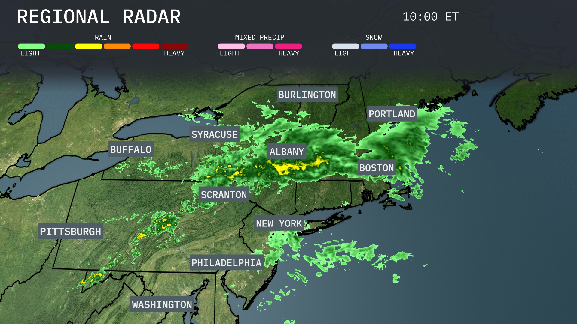
Rain is currently sweeping over the Northeast, with the heaviest showers concentrated from Syracuse, moving eastward through Albany, and into Boston. Scranton and New York City are seeing steady rain, with showers extending southeastward towards Philadelphia. Portland and Burlington are under a mix of light to moderate precipitation as this system pushes through. The line of rain appears broad with significant coverage, so expect wet conditions to persist for several hours across these areas.
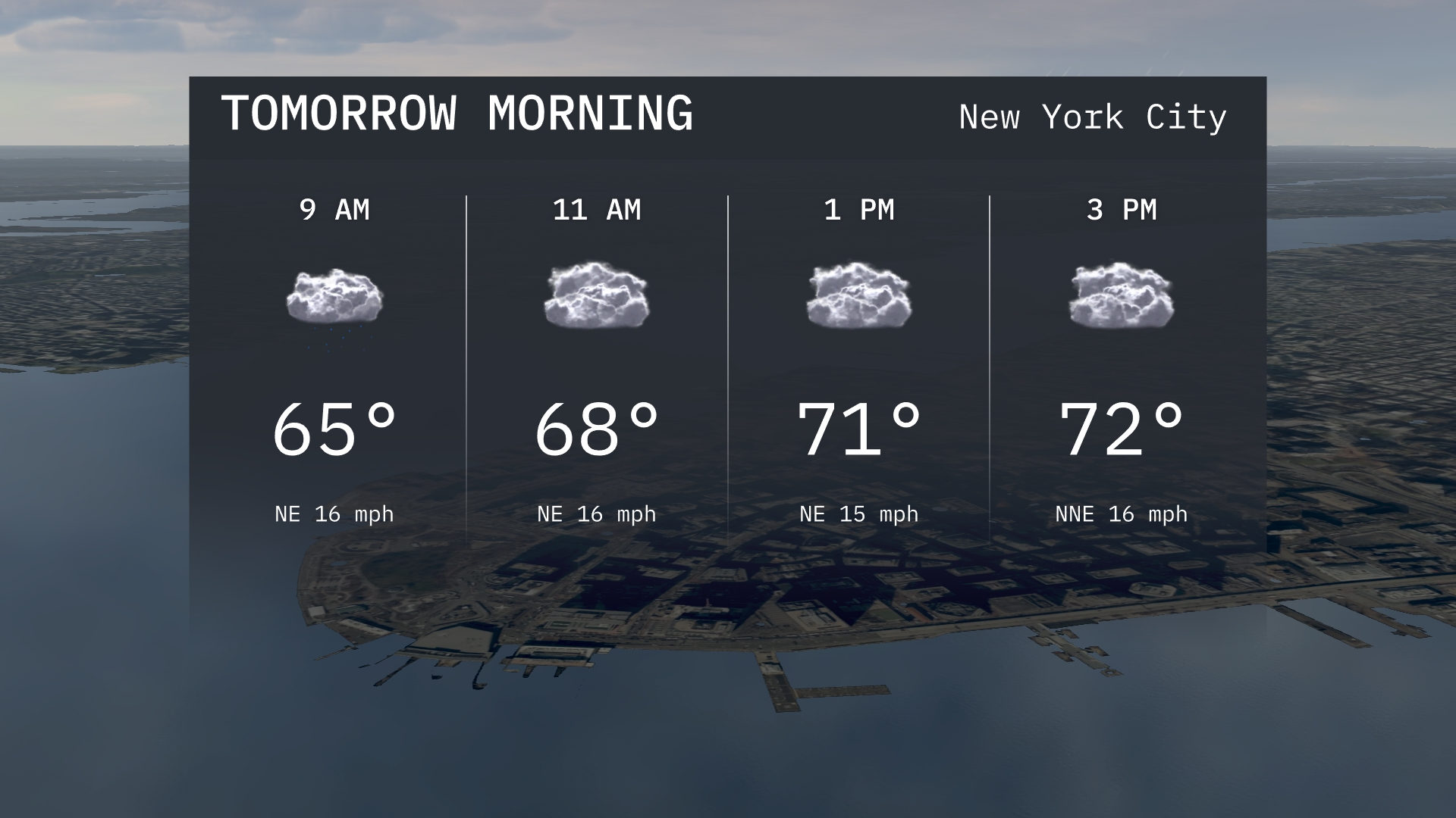
For tomorrow morning in New York City, expect overcast skies with temperatures starting at 65 degrees by 9 AM. The northeast wind will be steady at 16, contributing to a breezy start. By 11 AM, temperatures rise slightly to 68 degrees while the cloud cover persists.
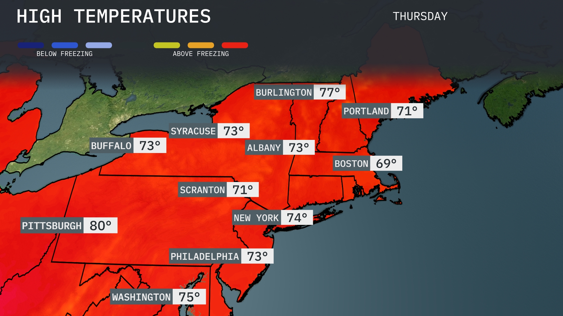
Tomorrow in the Northeast, expect some pleasant highs across the region. Pittsburgh will lead the way with a high of 80 degrees, while New York reaches 74. Philadelphia and Albany are both set for 73 degrees, and Syracuse will also enjoy a high of 73. Boston will be a bit cooler at 69 degrees, showing a slight dip compared to the rest of the area. Overall, temperatures are trending above average for this time of year, with a warm high-pressure system influencing the pleasant conditions.
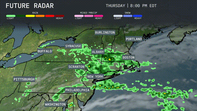
A frontal system will bring showers and scattered thunderstorms to the Northeast starting late Wednesday and continuing into Thursday. Expect periods of moderate to heavy rain especially from Albany to Boston, with rainfall totals potentially exceeding one inch. Cooler temperatures will follow the passage of the front, offering some relief from recent heat. Pay close attention if you’re in New York City and Philadelphia, as these urban areas may experience localized flooding during the storm. Conditions will improve by Friday, with skies gradually clearing and temperatures tapering off.
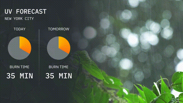
The UV index in New York City is a moderate 4 today, with a burn time of 35 minutes in direct sunlight. Tomorrow, expect similar conditions with the UV index staying at 4, continuing to require sun protection for extended outdoor activities. Don’t forget your sunscreen and enjoy the day!
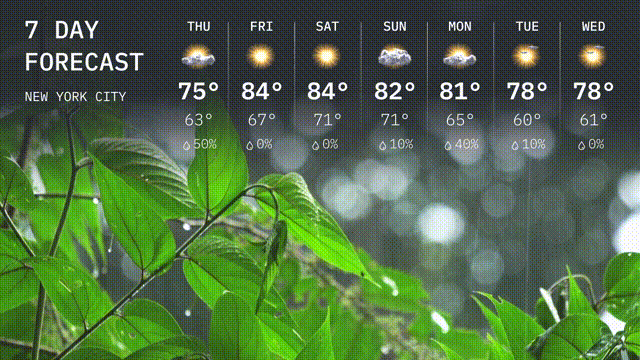
For the 7 Day Forecast in New York City:
Thursday: Pack an umbrella, as there’s rain in the forecast with a high of 75 degrees and a low of 63 degrees.
Friday: Expect a sunny day with temperatures climbing to a warm 84 degrees and a low of 67 degrees.
Saturday: Another warm day ahead with mostly sunny skies, hitting a high of 84 degrees and cooling to 71 degrees at night.
Sunday: Temperatures will be slightly cooler at 82 degrees with a nighttime low of 71 degrees under partly cloudy skies.
Monday: Scattered showers return, bringing a high of 81 degrees and a low around 65 degrees.
Tuesday: Partly sunny skies with highs reaching up to 78 degrees and lows near 60 degrees.
Wednesday: A similar day with partly sunny skies, a high near 78 degrees, and the low around 61 degrees.