Sunny Mornings and Stormy Nights: Miami’s Weather Forecast Detailed
By
Amy Freeze
Explore the dynamic weather patterns in Miami, including high UV indexes, scattered thunderstorms, and the week's temperature trends.
Keep up with Miami’s changing skies! This week predicts sunny mornings, high temperatures, and frequent thunderstorms. Stay prepared with our detailed insights.
In Miami, the weather remains vibrant and ever-changing. Enjoy clear, sunny mornings with temperatures soaring high as you kickstart your day. However, as the day progresses, prepare for scattered thunderstorms, which bring not just rain but also dramatic shifts in the weather. Our detailed forecast includes temperature trends, weather advisories, and tips to stay safe during higher UV index days and stormy weather. Follow our blog for daily updates and deeper insights into what these patterns mean for your week ahead.
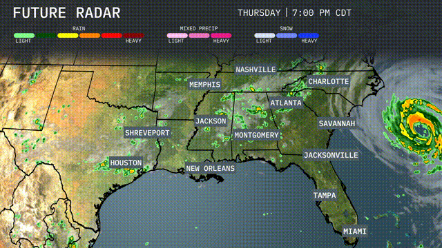
Rain showers are present over parts of southern Louisiana, including New Orleans, moving across the Gulf Coast. There are scattered showers around the Florida Peninsula, with Miami seeing ongoing rain. To the west, a band of thunderstorms is developing over central Texas, pushing towards Houston. Areas such as Shreveport and Jackson remain clear at this time, with no immediate precipitation expected.
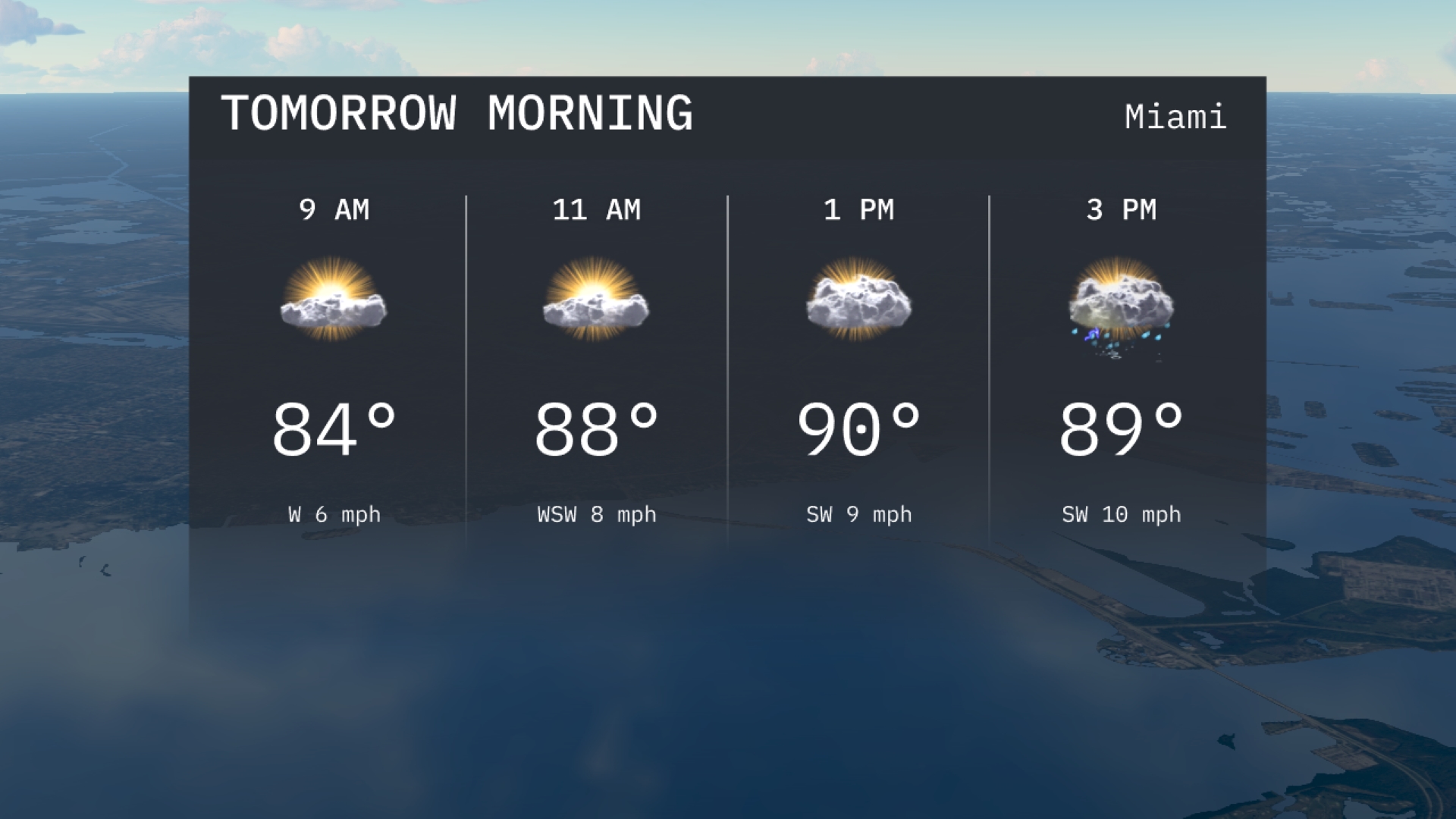
Tomorrow morning in Miami, expect warm conditions with temperatures starting at 84 degrees by 9 AM, rising to 88 degrees by 11 AM. Winds will be gentle, beginning from the west and shifting to west-southwest. Cloud cover will increase towards midday.
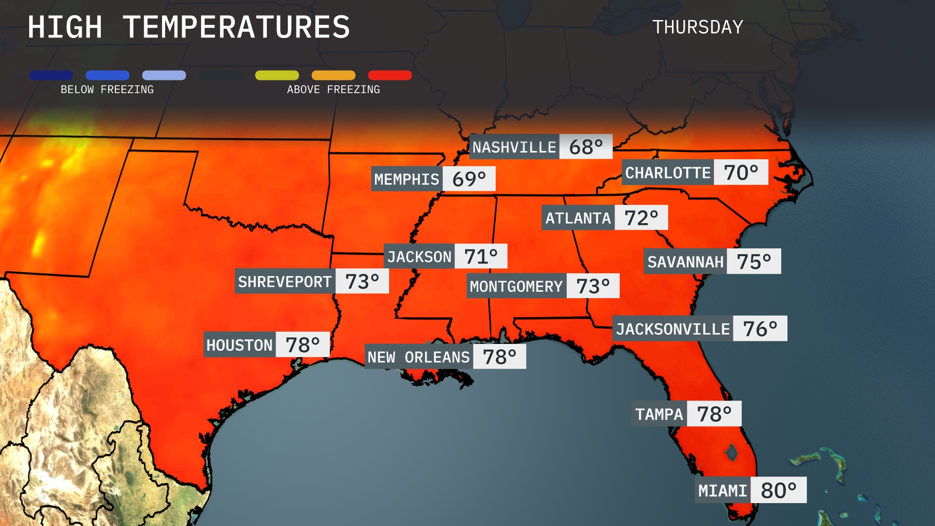
Tomorrow, Atlanta will reach a high of 72 degrees, while Jacksonville will see slightly warmer temperatures at 76. Over in Nashville, expect a cooler day with highs around 68 degrees. New Orleans will warm up to 78 degrees, aligning closely with averages for this time of year. Miami stands out with a high of 80 degrees, making it the warmest location in the Southeast as this region experiences a general warming trend.
A tropical system spins offshore the Southeast, bringing potential impacts of rain bands and gusty winds to coastlines from Charleston to Savannah tomorrow. Inland, isolated thunderstorms may pop up, particularly in areas like Atlanta and Montgomery through the afternoon. Temperatures remain warm, generally in the upper 80s to low 90s, but cooler air filters into northern areas behind a weak cold front. Watches may be posted for coastal flooding, so stay on alert if you’re near the ocean. This weather pattern persists over the next 48 hours, bringing variable conditions to parts of Florida and Georgia.
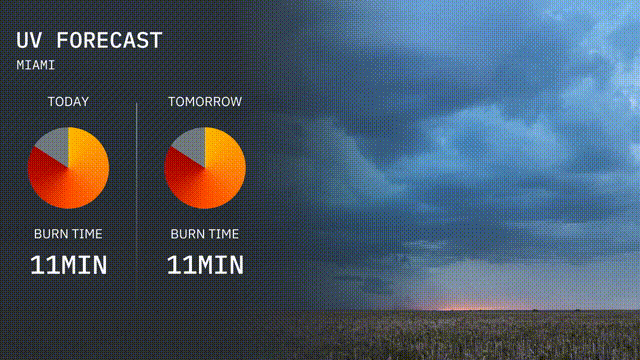
In Miami today, the UV index is high, reaching a level of 8, with sunburn possible in approximately 11 minutes of direct exposure. For tomorrow, the same high UV index of 8 continues, so make sure to protect your skin if spending time outdoors.
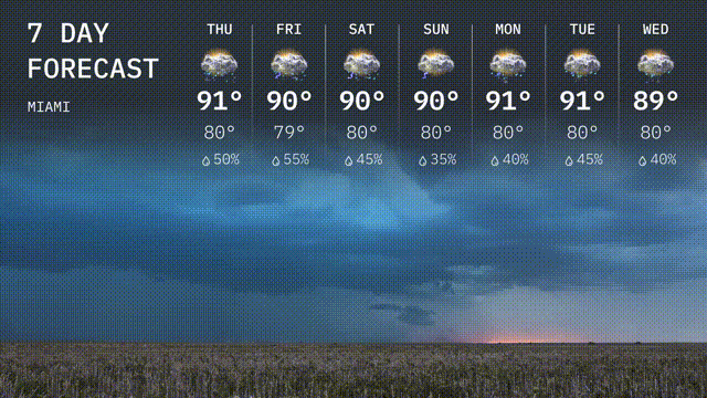
Thursday: A high of 91 degrees with scattered thunderstorms in the forecast. The low will be 80 degrees.
Friday: Thunderstorms continue with a high of 90 degrees and a low around 79 degrees.
Saturday: Expect more scattered storms with temperatures reaching 90 degrees for the high, cooling to 80 degrees at night.
Sunday: Thunderstorms linger, but temperatures stay consistent with a high of 90 degrees and a low of 80 degrees.
Monday: A mix of clouds and sun with thunderstorms possible, highs around 91 degrees and lows at 80 degrees.
Tuesday: The stormy pattern persists with a high reaching 91 degrees and a low of 80 degrees.
Wednesday: Thunderstorms continue, cooling slightly to a high of 89 degrees with a low of 80 degrees.