Miami Morning Glory & Thunderstorm Nights: This Week’s Weather Scoop!
By
Amy Freeze
Explore the ebb and flow of Miami's weather this week, from clear sunny mornings to unexpected thunderstorm evenings. Stay tuned with our comprehensive guide and be prepared for every weather swing!
This week in Miami, expect a mix of sunny mornings and stormy afternoons. With a detailed day-by-day forecast, we cover everything from UV safety to storm preparations.
Good morning, Miami residents and visitors! Prepare for a week of contrasts with our in-depth weather forecast. Starting off with mostly sunny skies, conditions are set to shift with the arrival of a cold front, bringing thunderstorms and potential flooding. Stay safe and informed with our thorough analysis including safety tips, daily temperatures, and storm predictions.
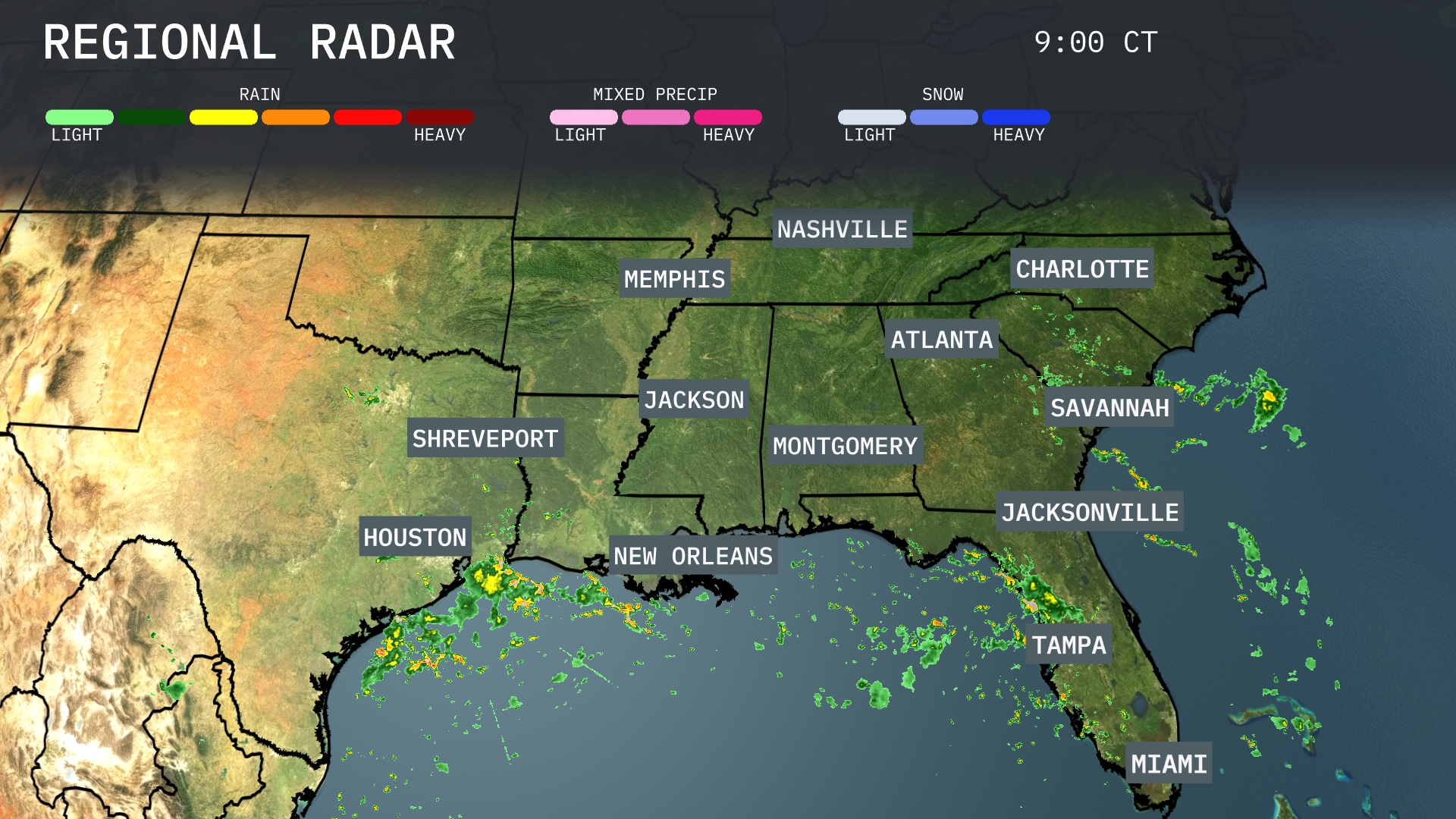
The Southeast region is experiencing active weather patterns today. Heavy rain is draping over areas from Houston tracing the coastline, stretching all the way to New Orleans. Scattered showers are also present across parts of central Florida, including Tampa and Miami. Meanwhile, areas like Atlanta and Charlotte remain clear, with clouds expected to increase as the day progresses.
Good morning, Miami! Tomorrow kicks off with temperatures rising from 84 degrees at 9 AM to 88 degrees by 11 AM. Expect mostly sunny skies initially with a light west-southwest breeze at 4 to 5 miles per hour. As the morning progresses, cloud cover will increase, setting the stage for possible showers in the afternoon.
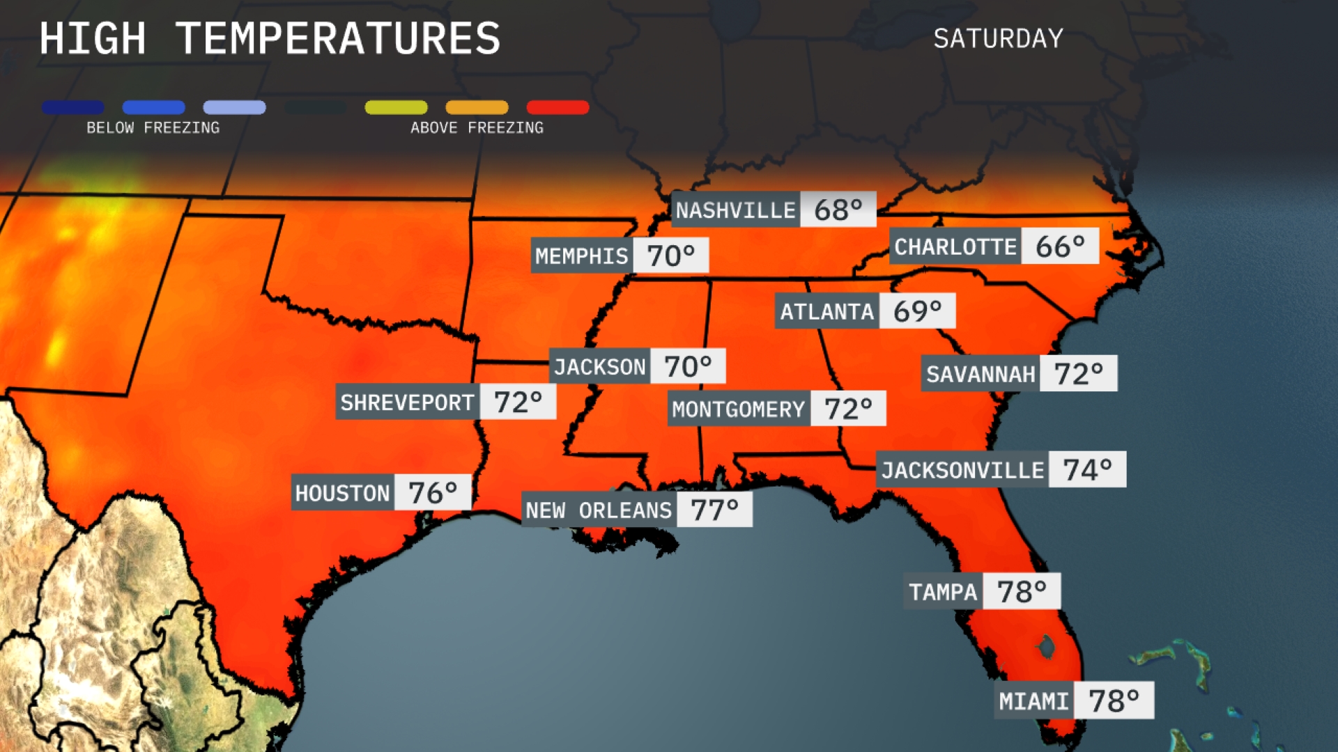
Tomorrow, Nashville will see a high of 68 degrees, while Memphis warms up to 70. Atlanta’s temperatures will peak at 69 degrees, with Montgomery hitting 72. Shreveport can expect a comfortable 72, and the coast in New Orleans will be warmer, reaching 77 degrees. In the Sunshine State, both Miami and Tampa are set for a warm 78 degrees, reflecting above-average temperatures for this time of year.
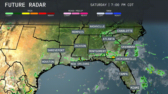
A cold front is pushing across the Southeast, leading to thunderstorms from Houston through New Orleans and Shreveport. Expect heavy rain by tomorrow with the highest concentration over Jackson and Memphis, potentially causing localized flooding. By afternoon, showers will reach Montgomery, Nashville, and Atlanta, likely affecting afternoon travel. Temperatures are forecasted to dip slightly in the wake of this front, providing a cooler end to the week. Stay alert for any severe thunderstorm warnings as the system progresses eastward.
Today, Miami’s UV index is high, reaching a level of 8, leading to a burn time of around 11 minutes in direct sunlight. For tomorrow, expect similar conditions with another high UV index of 8. Remember to apply sunscreen frequently and seek shade during peak sun hours for protection!
For the 7-day forecast in Miami:
Saturday: Expect a high of 89 degrees with scattered thunderstorms. Low around 78 degrees.
Sunday: Anticipate similar conditions with a high of 90 degrees and a low of 79, accompanied by a 50 percent chance of storms.
Monday: Thunderstorms continue with temperatures peaking at 91 degrees, and dipping to 79 degrees overnight.
Tuesday: A reprieve with partly sunny skies and a high of 91 degrees. Low around 80 with a 25 percent chance of rain.
Wednesday: Thunderstorms return, cooling things slightly to a high of 89 degrees, with a low of 79 degrees.
Thursday: More thunderstorms expected, with a high of 87 degrees and a low of 79 degrees, and a 40 percent chance of rain.
Friday: Closing the week with thunderstorms likely and temperatures reaching 87 degrees, cooling to 79 degrees at night.
Hope that helps! Stay safe!