Atlanta Gears Up for Sunshine Amid Southeast Soakers
By
Amy Freeze
While Atlanta enjoys a bright morning, a dynamic weather pattern across the Southeast promises thunderstorms and shifting temperatures. Dive into our comprehensive forecast.
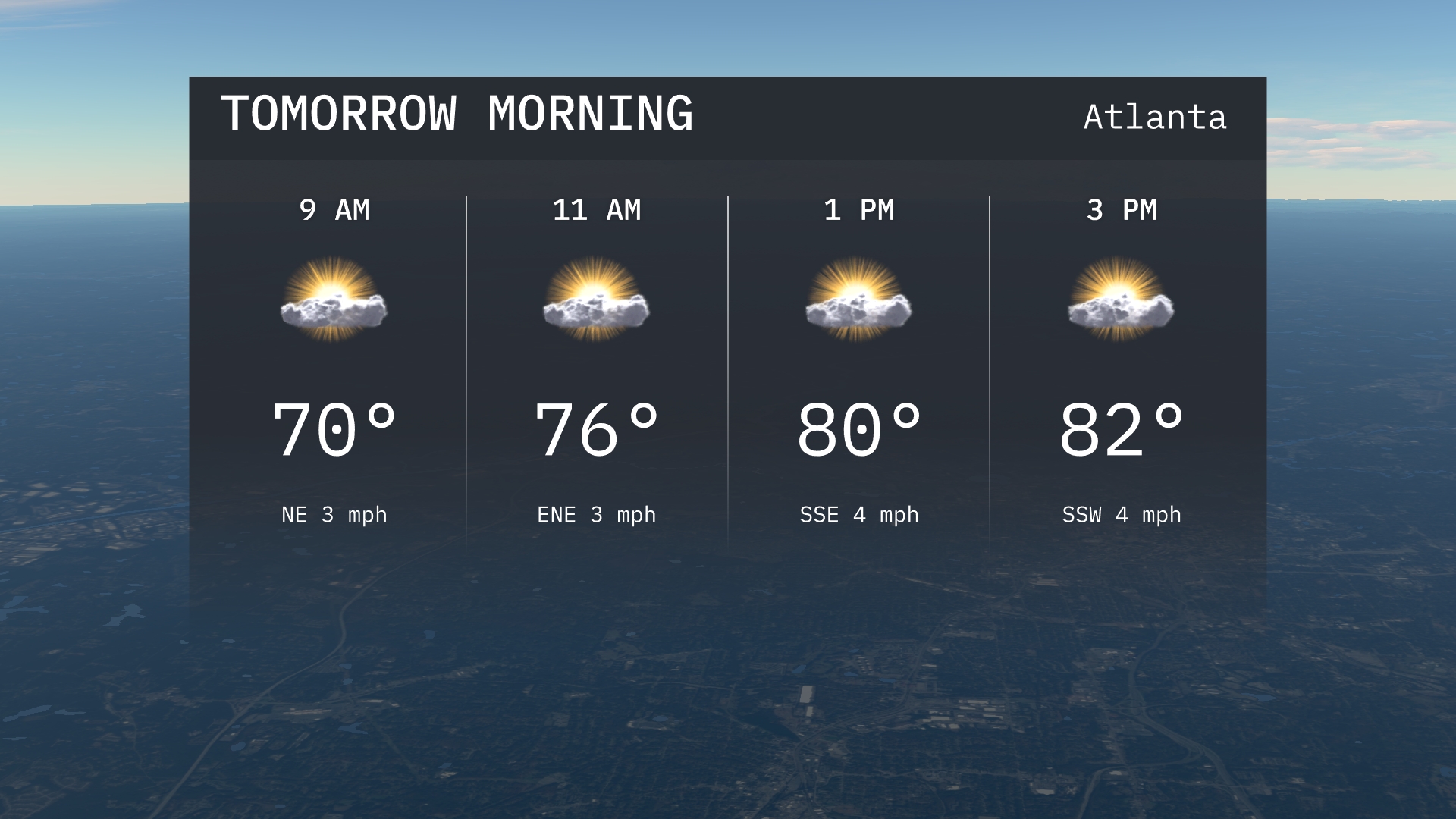
Get ready Atlanta! While tomorrow morning brings sunny skies, a band of storms from Jackson to Nashville may impact your plans. Stay updated with our detailed weather insights!
Welcome to our detailed forecast for Atlanta and the surrounding Southeast. Tomorrow, Atlanta will bask under sunny skies with temperatures inching from 70 to 76 by mid-morning. However, be prepared as moderate to heavy rain stretches from Jackson to Memphis, bringing much-needed relief but potential disruptions. The wider Southeast will see varied temperatures and potential thunderstorms as a cold front moves through, offering dynamic weather conditions throughout the week. Don’t forget, the high UV index requires sunscreen if you’re stepping out. Stay tuned for daily updates and stay prepared with our weather insights!
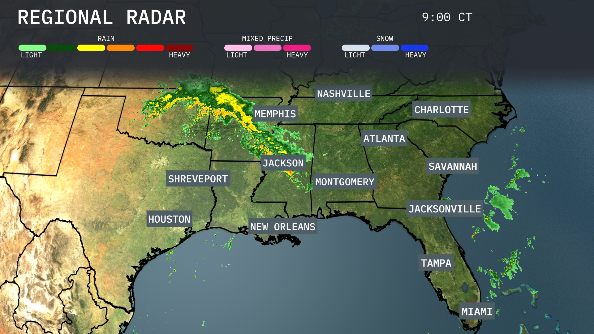
A band of moderate to heavy rain stretches from Jackson, Mississippi, up through Memphis, Tennessee, and into the Tennessee Valley. This storm system is advancing eastward toward Nashville and Birmingham, bringing much-needed precipitation. An isolated cluster of showers is developing off the Florida coast, heading towards Jacksonville. The Carolinas and Georgia are currently under partly cloudy skies but should prepare for impending rain as these systems progress.
Tomorrow morning in Atlanta, expect mostly sunny skies with temperatures starting at 70 degrees by 9 AM. The northeast breeze will accompany the warming trend to 76 degrees by 11 AM.
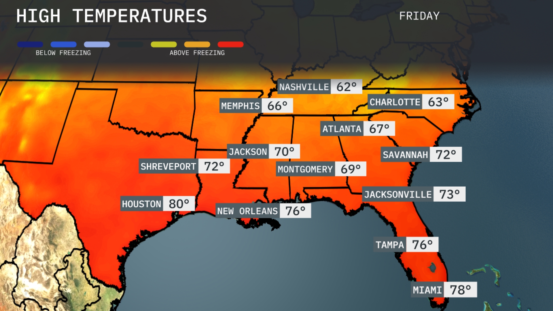
Tomorrow, Atlanta will experience a high of 67 degrees, slightly below average for this time of year. In Nashville, temperatures climb to 62 degrees, also on the cooler side for late summer. The warmth returns to the Gulf Coast with Houston reaching 80 degrees, well above typical readings. New Orleans is set to hit 76 degrees, maintaining seasonal warmth. Over in Miami, expect a warm high of 78 degrees, signifying a continued trend of summer-like conditions in the Southeast.
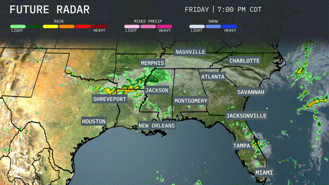
Across the Southeast tomorrow, expect a dynamic weather pattern as a cold front moves through, bringing thunderstorms from Shreveport to Montgomery and into southern Mississippi, potentially causing heavy rainfall and gusty winds. New Orleans may see isolated strong storms early on, with rain showers stretching from Jackson to Atlanta and up to Nashville by the afternoon. Watch for localized flooding concerns, particularly in low-lying areas prone to rapid accumulation. By late evening, showers will have shifted eastward towards Jacksonville and Savannah, providing much-needed moisture. Cooler, drier air will follow behind the front, with clearer skies expected by Thursday.
Today in Atlanta, expect a high UV index of 8 with a burn time of just 17 minutes, so apply sunscreen and stay shaded. Tomorrow, the UV index will remain at 8, yet slightly less intense with a burn time of 15 minutes under clear skies.
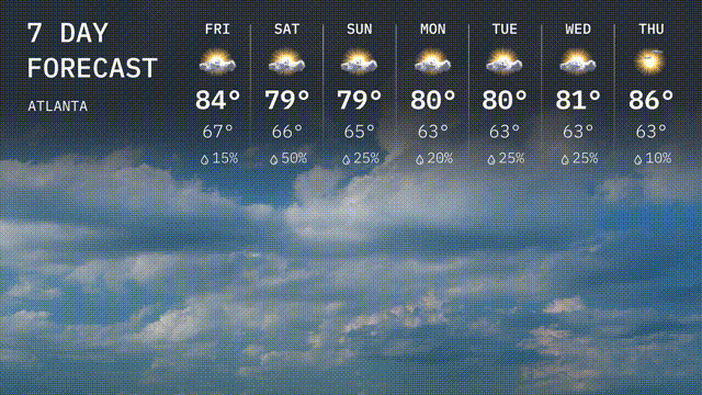
For the 7-day forecast in Atlanta:
Friday: Look for partly cloudy skies with a high of 84 degrees and a low of 67 degrees.
Saturday: Mostly cloudy with temperatures reaching 79 degrees and a low of 66 degrees.
Sunday: A mix of sun and clouds; the high will be around 79 degrees with a cooler night at 65 degrees.
Monday: Slightly warm with highs of 80 degrees under partly sunny skies, dropping to 63 degrees overnight.
Tuesday: More of the same; expect highs around 80 degrees and lows near 63 degrees.
Wednesday: A mix of clouds and sun as the temperature peaks at 81 degrees, with lows of 62.
Thursday: Looking warmer with a high of 86 degrees and a low of 63, under partly cloudy skies.