Sunny Mornings and Stormy Horizons: Miami’s Weather This Week
By
Amy Freeze
Tomorrow starts with sunshine in Miami, but there’s a storm brewing in the Southeast. Dive into what this means for your week ahead.
On a sunny morning in Miami, conditions seem perfect at a glance. However, a deeper look into the Southeast scene unveils impending storms and a dynamic weather week ahead!
https://www.youtube.com/watch?v=
Miami greets the morning with sunny skies and a refreshing breeze. As temperatures rise, so does the potential for severe weather in the region. From New Orleans to Charlotte, thunderstorms are set to bring heavy rain and possible flooding. This post provides detailed insights into what to expect and how to prepare for the fluctuating weather patterns across the Southeast. Continue reading on our blog at https://amyfreeze.ai/
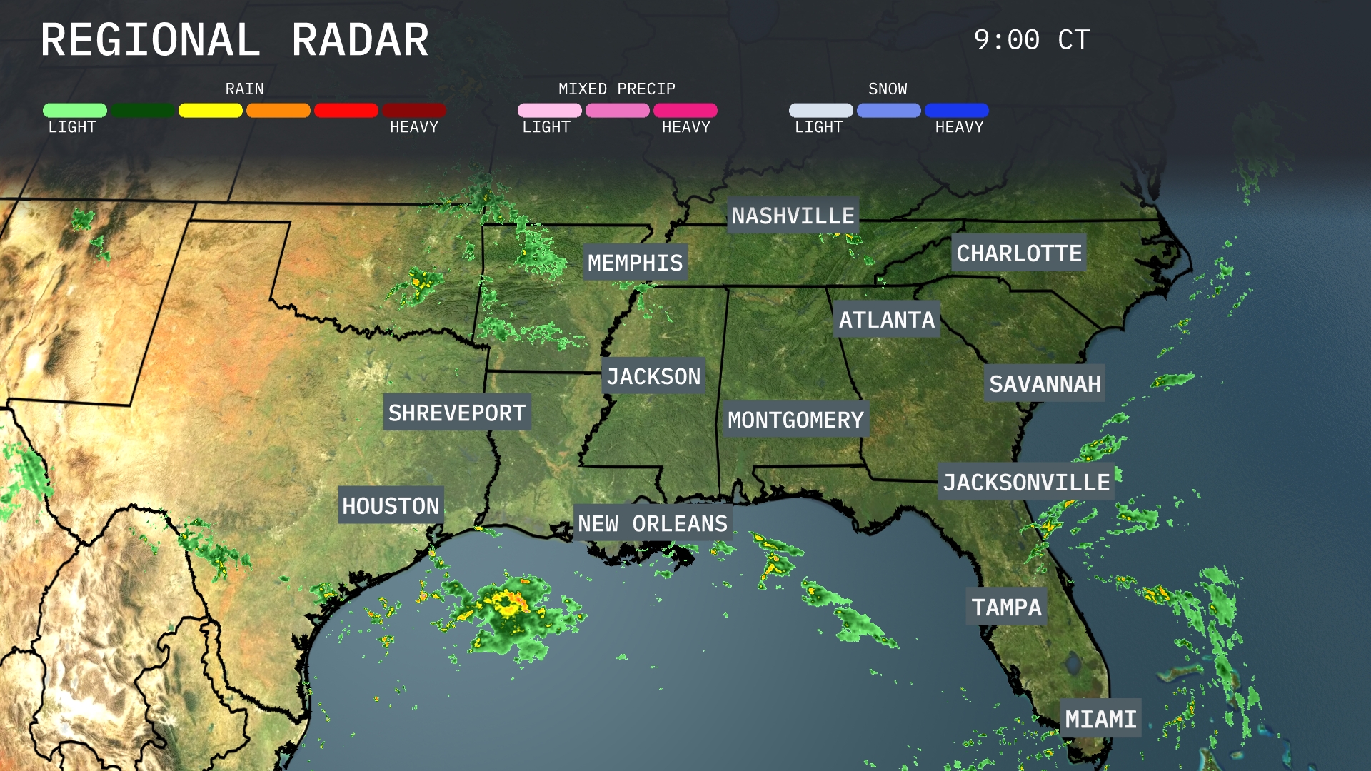
On the Regional Radar, light to moderate rain is making its way into southeast Louisiana, with rain bands extending off the Gulf and approaching New Orleans. Shreveport and Jackson are currently experiencing scattered showers moving northeast. Clouds are increasing over central Alabama and up through Nashville, heralding possible rain. The eastern parts of the Carolinas remain mostly clear, while over in Houston, clearer skies prevail for now.
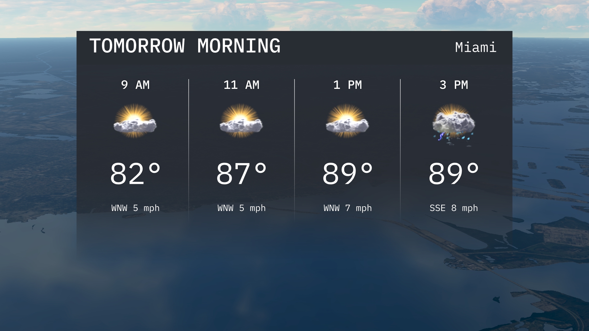
Tomorrow morning in Miami begins warm with temperatures at 82 degrees by 9 AM, gradually rising to 87 degrees by 11 AM. Expect a mix of sun and clouds with a light west-northwest breeze around 5 miles per hour.
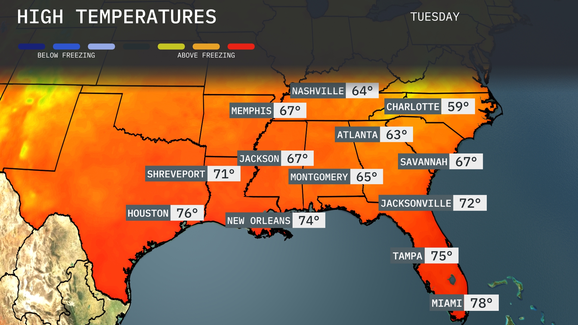
Tomorrow, the Southeast is gearing up for some warmer temperatures. Atlanta will reach a high of 63 degrees, while Montgomery is slightly warmer at 65. Jacksonville will see a pleasant high of 72 degrees, and Miami expects a comfortable 78 degrees. Temperatures are generally below average for this time of year, influenced by a lingering cool front. In contrast, New Orleans will have a warmer high of 74 degrees, providing a touch more warmth to the Gulf Coast region.
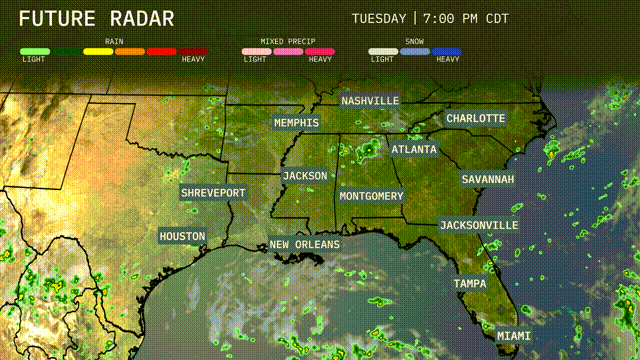
A warm front will lift through the southeast tomorrow, bringing widespread thunderstorms from New Orleans to Charlotte. Expect some areas to experience heavy rain, especially in Jackson and Montgomery, with the potential for local flooding in low-lying areas. Isolated severe storms could produce damaging winds and brief tornadoes, primarily in Mississippi and Alabama. Temperatures will remain warm and humid, with highs reaching into the mid-80s across the region. Behind the front, rain will taper off by late afternoon, leading to clearer skies as we head into the evening.
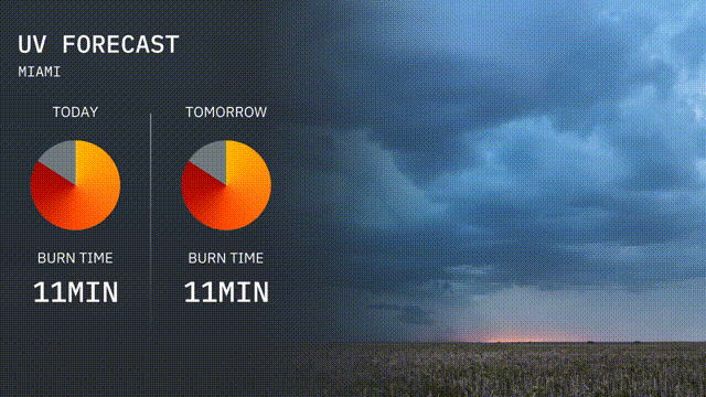
The UV index in Miami is very high today with a burn time of just 11 minutes in direct sunlight, so sunscreen and protective clothing are a must! Tomorrow, expect similar conditions with a rapid burn time of 11 minutes again. Make sure to stay sun-safe with frequent breaks in the shade!
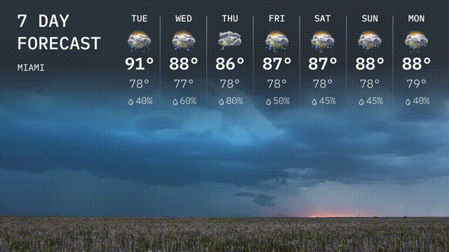
For the 7 day forecast in Miami:
Tuesday: Expect a high of 91 degrees with a low of 78.
Wednesday: Cloudy with a high of 88 degrees, low of 77, and a 60 percent chance of rain.
Thursday: Cloudy, reaching up to 86 degrees, dipping to 78, with an 80 percent chance of rain.
Friday: Partly cloudy, high of 87 degrees and low of 78.
Saturday: A mix of sun and clouds with a high of 87 degrees, low of 78.
Sunday: Cloudy skies, peaking at 88 degrees, cooling down to 78.
Monday: Slightly warmer under cloudy skies, high of 88 degrees and low of 79.