Midwest Maelstrom: Navigating Through Chicago’s Weather Woes
By
Amy Freeze
Explore the tumultuous weather patterns over Chicago and the broader Midwest, including severe storms and chilly forecasts, with insights from meteorologist Amy Freeze.
Amy Freeze provides a snapshot of upcoming weather in Chicago and the Midwest, highlighting potential severe storms and the need for preparedness.
Dive deep into the upcoming weather changes in Chicago and surrounding areas. Meteorologist Amy Freeze explains the forecasted cloudy skies, severe storm risks, and temperature fluctuations. Understand the implications for daily activities and safety precautions necessary to tackle these weather challenges.
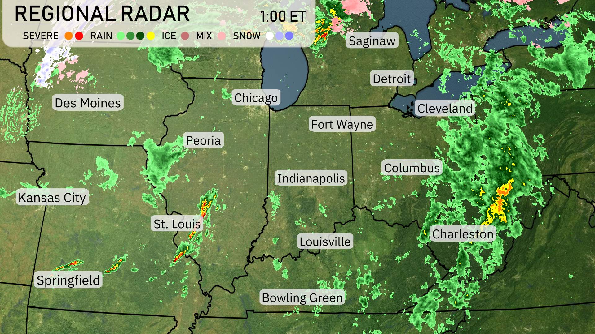
The Midwest region is experiencing a mixed bag of weather today. Be aware of severe weather east of the Mississippi River. Check in with the Storm Prediction Center for the latest threats and timing of the storms. As we scan the radar, we see a significant line of storms stretching through Peoria. St. Louis is right in the path, dealing with intense storm activity. If you move farther east, Indianapolis is seeing widespread rain, which extends northeastward towards Fort Wayne and even reaching into Detroit.
For those in the Chicago area, you’re under overcast skies with rain not far on the western horizon. Down in Louisville and Bowling Green, showers are persistent, moving eastward. Meanwhile, Columbus, Ohio, is already in the heart of consistent rainfall, and farther east, Charleston is also experiencing wet conditions, with more rain creeping in from the west.
The northern parts, nearing Saginaw, are under soggy conditions with periodic showers, while Cleveland sees continued rain showers moving in from the west.
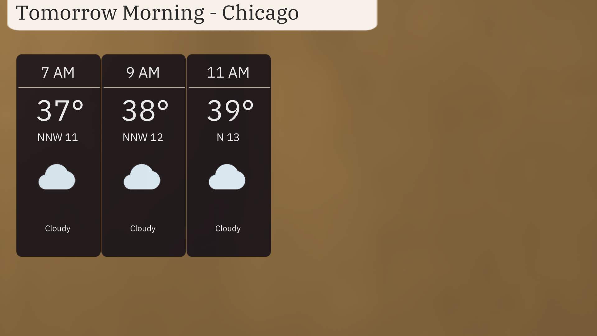
As you start your morning in Chicago, anticipate cloudy skies with a temperature of 37 degrees at 7 AM and a north-northwest wind at 11 miles per hour. By 9 AM, temperatures rise slightly to 38 degrees with winds shifting to the north-northwest at 12 miles per hour. By 11 AM, expect temperatures to reach 39 degrees with a north wind at 13 miles per hour.
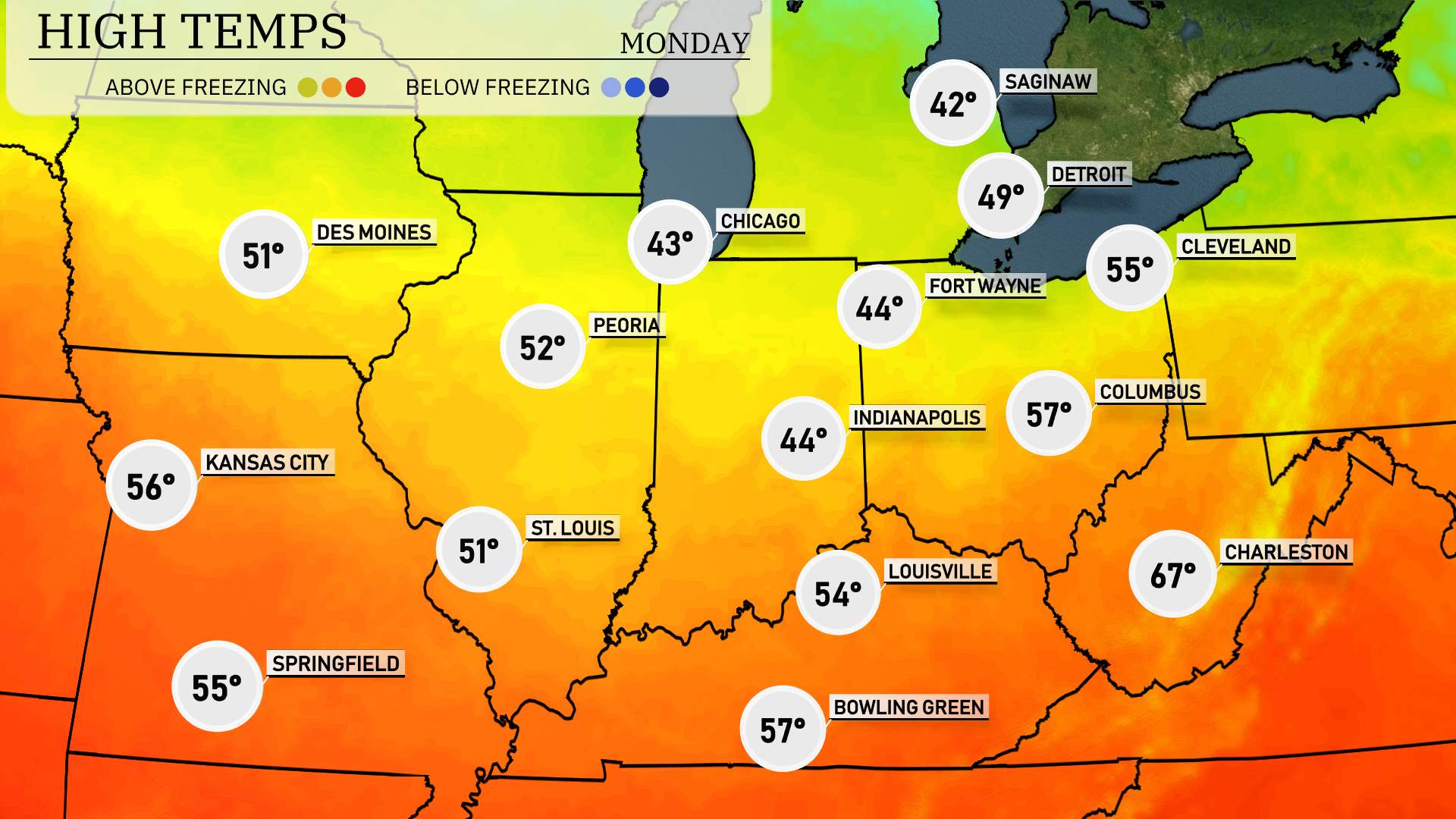
High temperatures across the Midwest tomorrow will show a mix of mild conditions as a warm front moves through the region.
In Chicago, expect a high of 43 degrees, which is slightly below average for this time of year. St. Louis will see a bit warmer conditions with highs reaching 51 degrees. Heading into Indiana, Indianapolis will struggle with a high of only 44 degrees, while nearby Fort Wayne remains cool at 44 as well.
Kansas City is set to warm up a notch, reporting a high of 56 degrees, and Peoria will see 52 degrees. Moving towards the Ohio Valley, Columbus could see a high of 57 degrees, while Louisville will touch 54.
In southern regions, Charleston is making it into the 60s with a high of 67 degrees, providing a warmer contrast to the northern cities.
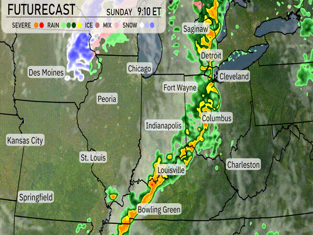
Severe weather risks are on the doorstep for parts of the Midwest as a line of storms is set to track eastward. Be prepared for possible damaging winds and heavy rainfall from Chicago to Detroit, extending eastward into Cleveland and Saginaw. Areas farther south, such as Louisville and Indianapolis, should be on alert as the storm line advances. With the potential for isolated tornadoes in these areas, it’s crucial to stay weather aware. Expect cooler temperatures to follow the storm, creating a sharp drop in the mercury after it passes.
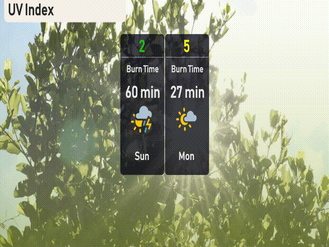
The UV index in Chicago is low today at 2, with a storm system offering protection from harmful UV rays. On Monday, expect a moderate UV index of 5 with a burn time of about 27 minutes.
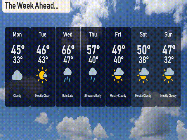
For the 7-day forecast in Chicago:
Monday: Cloudy with a high of 45 degrees and a low of 33.
Tuesday: Mostly clear skies, highs reaching 46 degrees, and a low of 43.
Wednesday: Rain late in the day, temperatures rising to 66 degrees with a low of 47.
Thursday: Showers early with a daytime high of 57 degrees and a low of 40.
Friday: Mostly cloudy, expect a high of 49 degrees and a low of 40.
Saturday: Mostly cloudy, with temperatures peaking at 50 degrees and a nighttime low of 38.
Sunday: Wrap up the weekend mostly cloudy, with a high of 47 degrees and a low of 32.
Stay safe!