Thunderstorms to Sunshine: A Southeast Weather Odyssey
By
Amy Freeze
Meteorologist Amy Freeze guides us through a transect of weather conditions in the Southeast, from stormy skies to sunny days.
Experience a dramatic shift in weather across the Southeast as Amy Freeze breaks down the latest forecasts. From thunderstorms escalating across regions to unexpected sunny breaks, get all the insights in a comprehensive update.
Welcome to a captivating weather journey across the Southeast with your favorite meteorologist, Amy Freeze. Tonight, Atlanta braces for increasing thunderstorm activity with southerly breezes making the evening interesting. As we examine regional highs and expect contrasts, Florida sizzles, while northern areas cool down. A cold front is on the move, promising significant changes. Stay updated on the breadths of weather patterns, ranging from rainy days to clear, sunny skies. Essential reading for weather enthusiasts and residents across the Southeast. Visit our detailed blog post for more! 🔗 https://amyfreeze.ai/
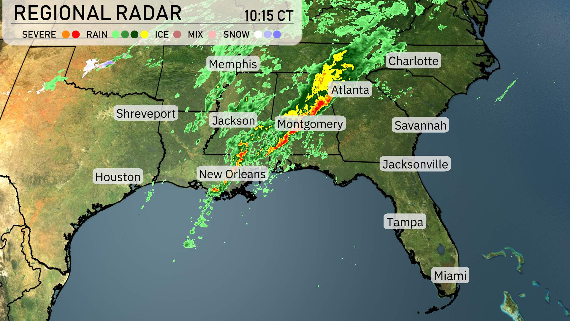
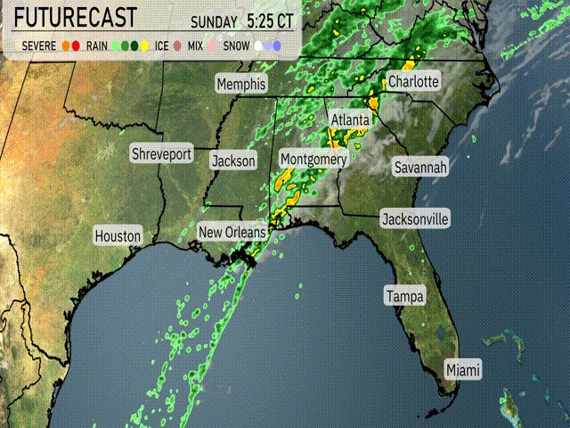
A dynamic line of storms is advancing across the Southeast, moving from west to east. Storms are intensifying from Shreveport, Louisiana, stretching towards Montgomery, Alabama. Heavy rain continues around Jackson, Mississippi, pushing northeast toward Atlanta, Georgia. Thunderstorm activity is picking up in Memphis, Tennessee, as the storms make their way farther into the Tennessee River Valley.
The region is witnessing an increase in cloud cover over Georgia, moving into the Carolinas, while rainfall is becoming more widespread. Eastern Louisiana is experiencing scattered showers, and New Orleans is under a blanket of rain. Coastal areas, such as Savannah, Georgia, and Charleston, South Carolina, are temporarily enjoying a break from the rain. Meanwhile, Jacksonville, Florida, is clearing out, with skies becoming brighter in northern portions of the state.
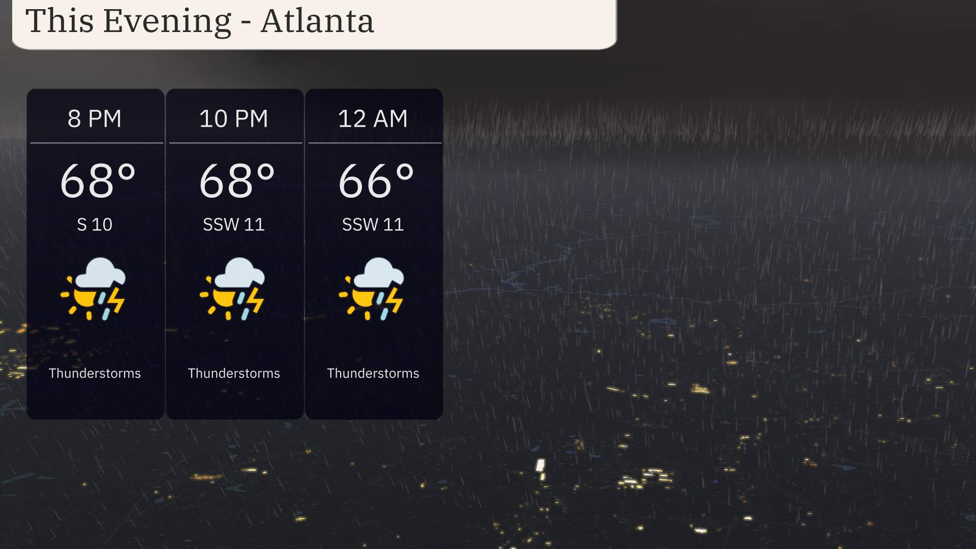
For this evening in Atlanta, expect increasing thunderstorm activity as temperatures hold steady at 68 degrees at 8 PM, slightly dipping to 66 by midnight. Southerly winds will vary between 10 and 11 miles per hour, adding a breezy touch to the night. Keep an eye on those thunderstorms as they might be accompanied by occasional lightning and heavy downpours.
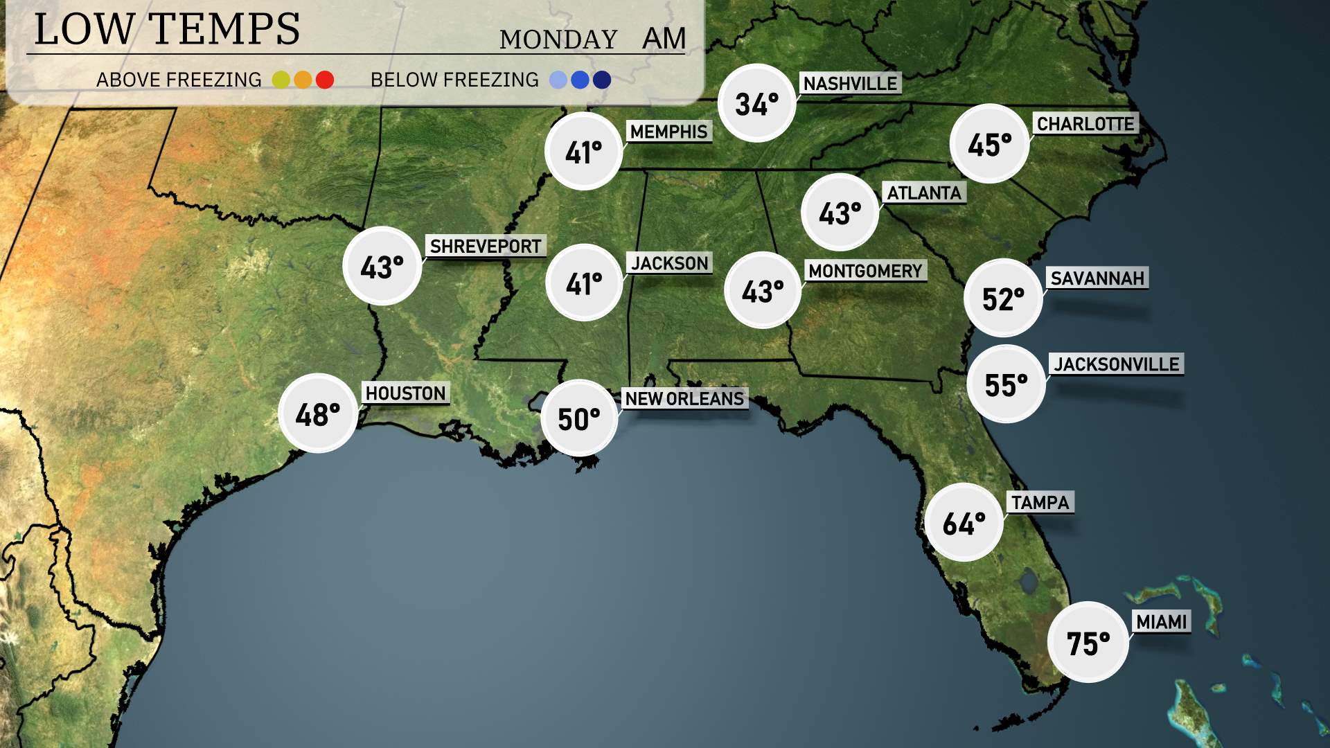
The Southeast will experience quite a chilly night, with lows dipping into the upper 30s and lower 40s across many areas. Expect 34 degrees in Memphis, a notable drop from recent temperatures. Nashville will see a low of 41. Jackson is forecasted at 41 as well, with Montgomery close behind at 43. In Atlanta, temperatures will fall to 43 degrees. Savannah will be a bit warmer at 52, while Jacksonville hits 55. New Orleans will stay relatively mild at 50. Tampa rounds it out with a low of 64, and Miami will remain quite warm at 75.
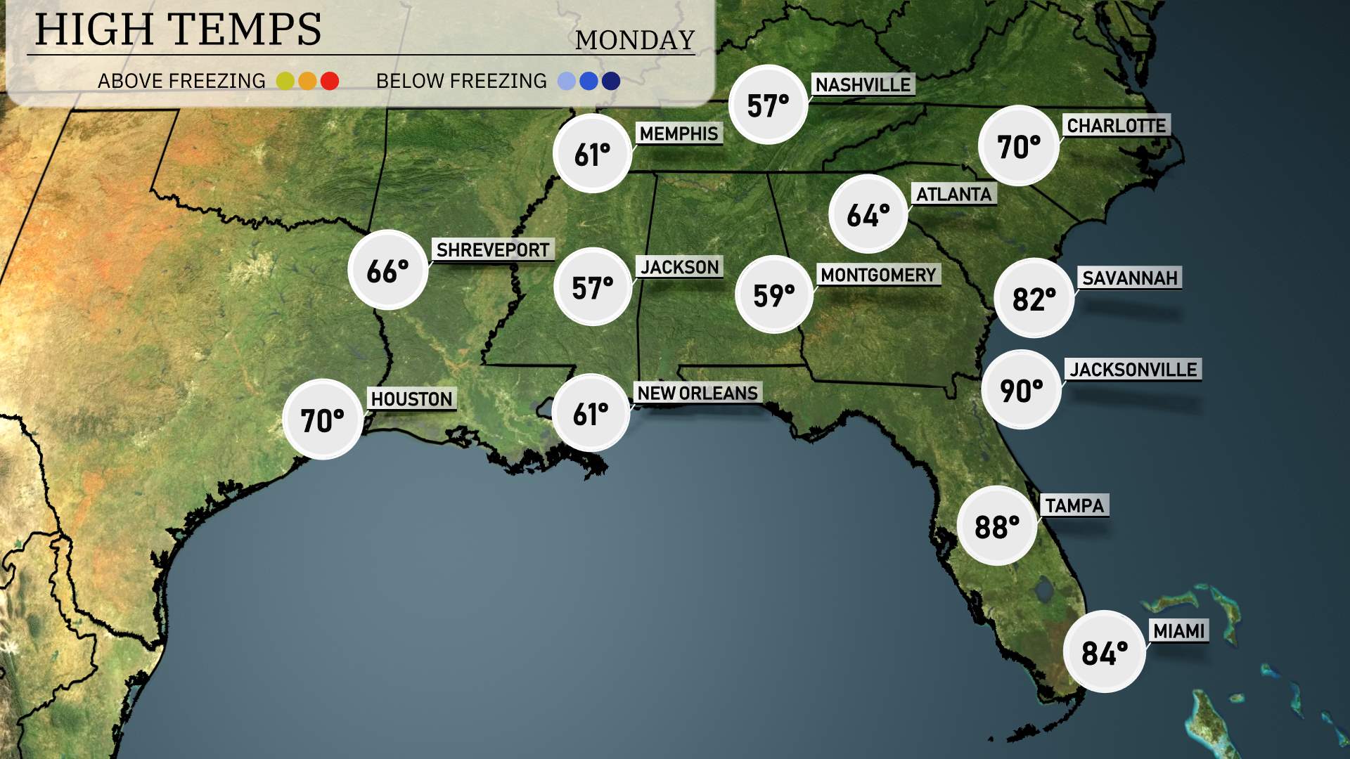
Tomorrow, the Southeast region is gearing up for a warm day, with many areas seeing above-average temperatures thanks to a surge of humidity moving in.
In Atlanta, expect a high of 70 degrees, which is quite mild for this time of year. Charlotte will also see pleasant conditions, reaching 70 degrees as well. Further south, Savannah is looking at a warm afternoon high of 82 degrees, while Jacksonville is set to soar to 90 degrees.
Tampa is not far behind with a high of 88 degrees, and Miami will enjoy a warm 84 degrees. Meanwhile, Austin will have a high of 76 degrees, and Houston is expected to see a high of 70 degrees.
A strong weather system impacts the Southeast with a cold front moving eastward from Louisiana towards the Carolinas. Expect thunderstorms and heavy rain across Montgomery and Atlanta. With potentially damaging winds, stay alert. On Sunday, from New Orleans to Jacksonville, expect scattered showers and isolated thunderstorms, particularly during the evening hours. The severe weather risk is elevated, with the SPC highlighting parts of Alabama and Georgia. Be prepared for weather warnings through Monday. Cooler, drier air behind the front will bring a brief relief from the humidity.
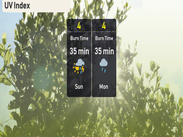
The UV index in Atlanta will be moderate on Sunday, with a value of 4 indicating a burn time of about 35 minutes in direct sunlight. For Monday, the UV index remains at 4, also giving a burn time of 35 minutes. Stay sun-safe by wearing sunscreen and protective clothing!
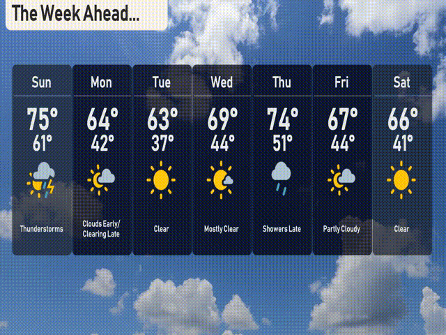
For the 7-day forecast in Atlanta:
Sunday: Expect thunderstorms with a high of 75 degrees and a low of 61 degrees.
Monday: Clouds early with clearing late, highs will be around 64 degrees and a low of 42 degrees.
Tuesday: A clear day with a high of 63 degrees and a low of 37 degrees.
Wednesday: Mostly clear skies, warming up with a high of 69 degrees and dipping to 44 at night.
Thursday: Showers arrive late, temperatures will peak at 74 degrees, cooling to 51 degrees.
Friday: Partly cloudy with a daytime high of 67 degrees and a nighttime low of 44 degrees.
Saturday: A clear day with temperatures reaching 66 degrees and a low of 41 degrees.
Hope that helps! Stay safe and enjoy the week ahead!