Navigating Through Nimbuses: Miami’s Mixed Weather Forecast Unveiled
By
Amy Freeze
Catch the varying skies over Miami — from the joy of mild temps to the caution of severe storms. Detailed forecast inside!
Meteorologist Amy Freeze brings you the latest weather news for Miami and the Southeast region. Expect a sunny but storm-laden forecast!
Welcome to your detailed weather guide by Amy Freeze! Miami enjoys partly cloudy skies today, but don’t let the sun deceive you — a major storm system is stirring up from Texas to Tennessee, promising a spectrum of weather experiences across the Southeast. Keep an eye on the skies this week, and always stay prepared!
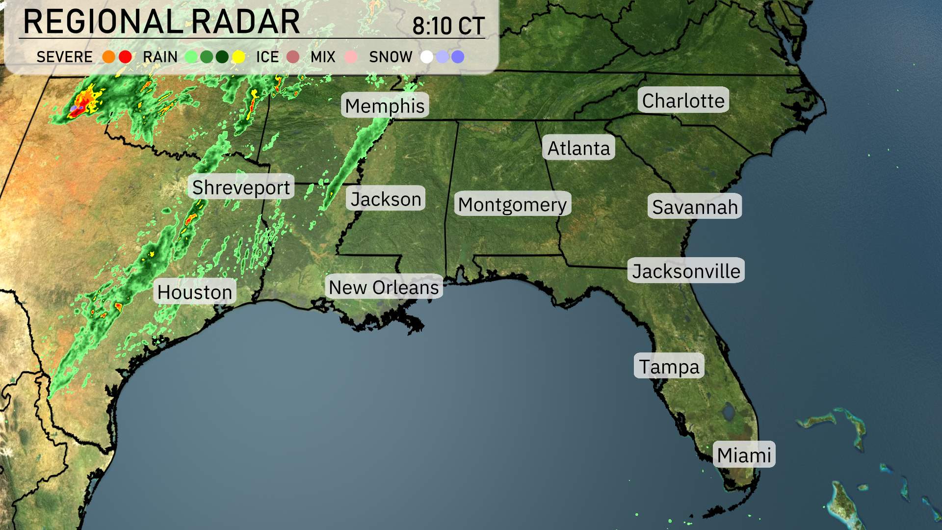
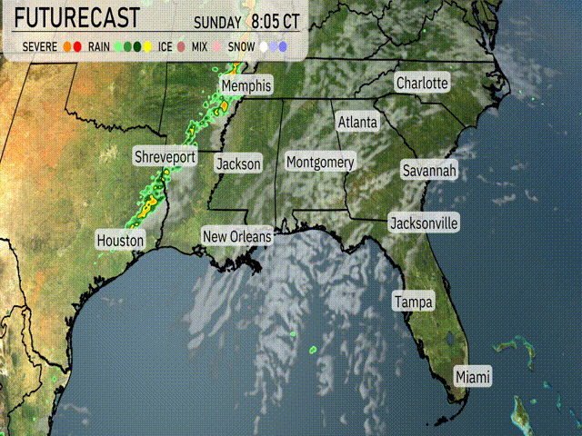
A significant line of storms is making its way from eastern Texas through parts of the Lower Mississippi Valley. Shreveport is currently experiencing strong thunderstorms moving eastward towards Jackson and Memphis. Rain is spreading across northern Mississippi, heading towards Alabama with increasing cloud cover in places like Montgomery. Cities like Houston and New Orleans are enjoying a brief respite from severe weather. Coastal regions including Jacksonville and Miami are looking at partly cloudy skies with no rain in sight.
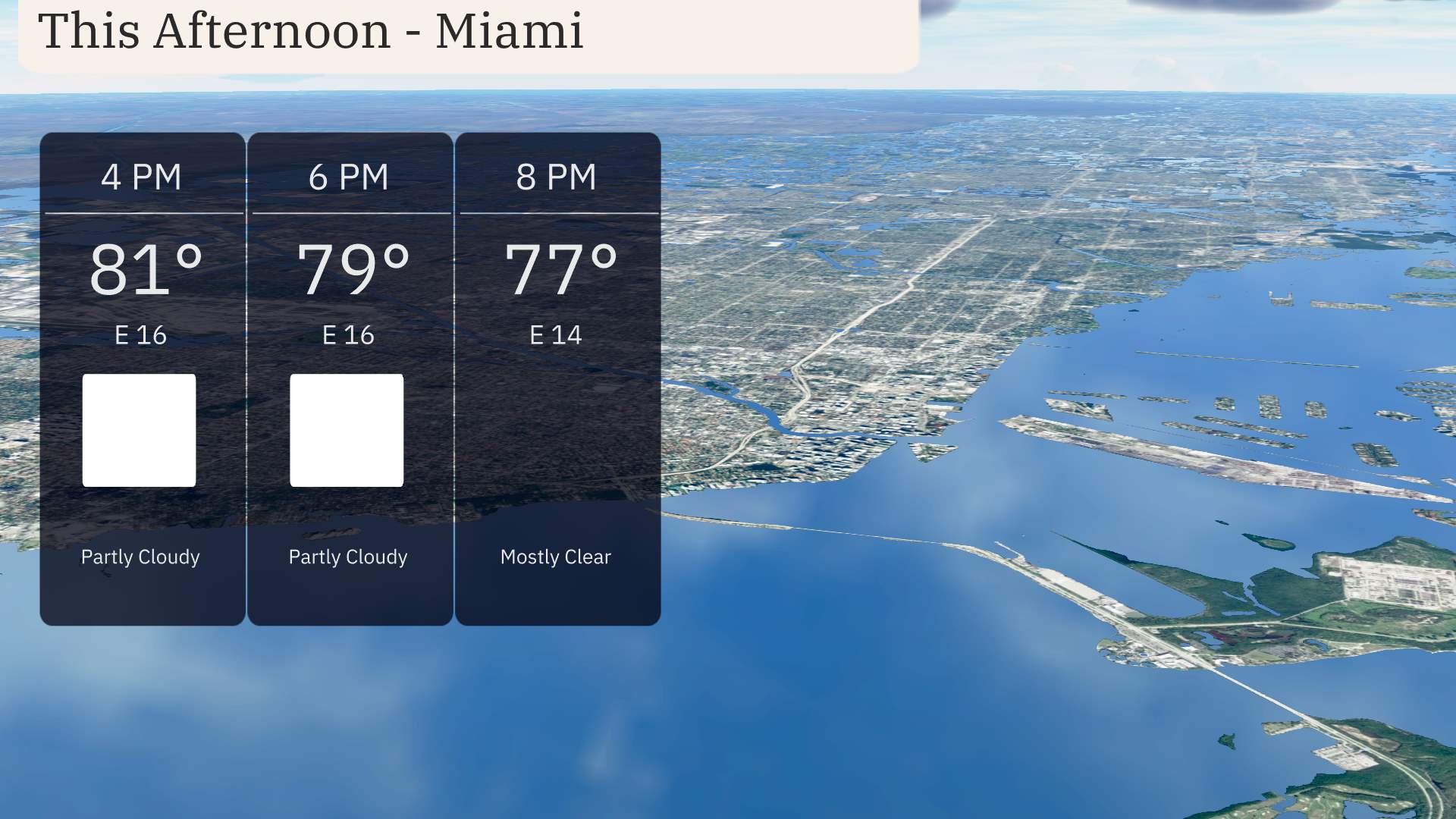
This afternoon in Miami, temperatures will ease from 81 degrees at 4 PM to 77 degrees by 8 PM. Expect partly cloudy skies transitioning to mostly clear as the evening progresses. Winds will be moderate, coming from the east at 14 to 16 miles per hour, providing a light breeze through the area.
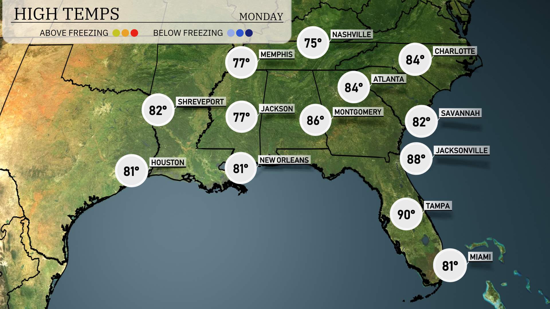
In the Southeast today, Atlanta will reach a high of 84 degrees, while Montgomery is slightly warmer at 86. New Orleans and Houston both settle at 82 degrees. Further east, Jacksonville will hit 84 degrees, contrasting with Savannah, which is a bit cooler at 81. Over in Tampa, expect a hot high of 90 degrees, making it the warmest spot in the region.
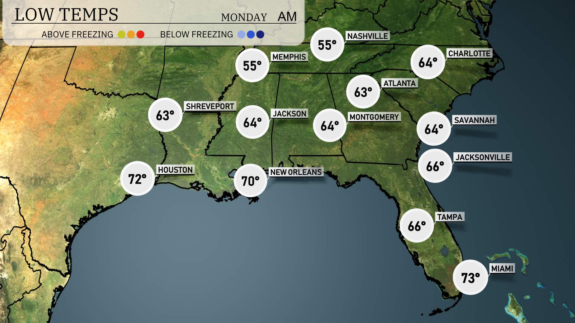
Low temperatures tonight in the Southeast will bring a brisk chill to the region. Expect 55 degrees in Memphis and Nashville. Shreveport will cool to 63, while Jackson drops to 64. Montgomery and Atlanta will have overnight lows of 64 degrees, and further south, New Orleans sits at 70. Miami remains mild at 73, showcasing the warmer climate as much of the Southeast feels the bite of cooler air.
High temperatures in the Southeast tomorrow will trend above average as warm air settles in. Atlanta is set to reach 84 degrees, while Charlotte will see a high of 84 as well. In Florida, Tampa will sizzle at 90 degrees, and Jacksonville will be close behind at 88. New Orleans and Montgomery are also expecting warm afternoons, with highs of 81 and 86 degrees, respectively.
A strong line of thunderstorms will push through the Southeast starting from Shreveport and Houston, advancing towards Memphis and reaching New Orleans by tomorrow afternoon. Expect severe weather conditions with potential for damaging winds and isolated tornadoes, especially near Jackson and Montgomery. Rainfall will be heavy at times, contributing to localized flooding concerns. Temperatures will drop as the front moves through, bringing cooler air by late evening. As the system moves east, cities like Atlanta and Charlotte should prepare for stormy conditions as well.
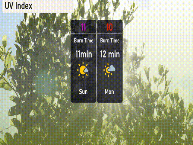
In Miami, the UV index will soar to 11 on Sunday, meaning sun exposure can lead to skin damage in just 11 minutes. Monday, the UV index will slightly drop to 10, but protection is still crucial with a burn time of only 12 minutes.