Salt Lake City Weather Update: Clouds, Sun, and a Chance of Showers!
By
Amy Freeze
Explore detailed weather forecasts for Salt Lake City and the Southwest with expert insights from Meteorologist Amy Freeze. From tonight’s cloudy skies to the week’s sun and showers, stay prepared!
Discover what’s brewing over Salt Lake City! Meteorologist Amy Freeze provides tonight’s weather outlook and a sneak peek at the upcoming week, marked by varying temperatures and potential showers.
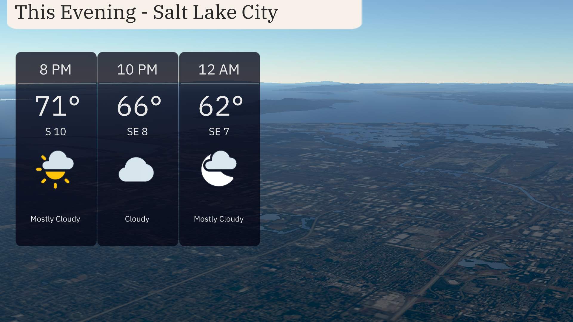
Welcome to your go-to source for Salt Lake City weather forecasts, presented by seasoned meteorologist Amy Freeze. Tonight, the city faces mostly cloudy skies with temperatures cooling from 71 to 62 degrees. As we look ahead, expect intermittent showers and a mixed bag of temperatures across the Southwest. Stay tuned for our daily updates and expert predictions as weather patterns shift. For an in-depth daily forecast, visit our full blog at https://amyfreeze.ai/salt-lake-city-weather-update.
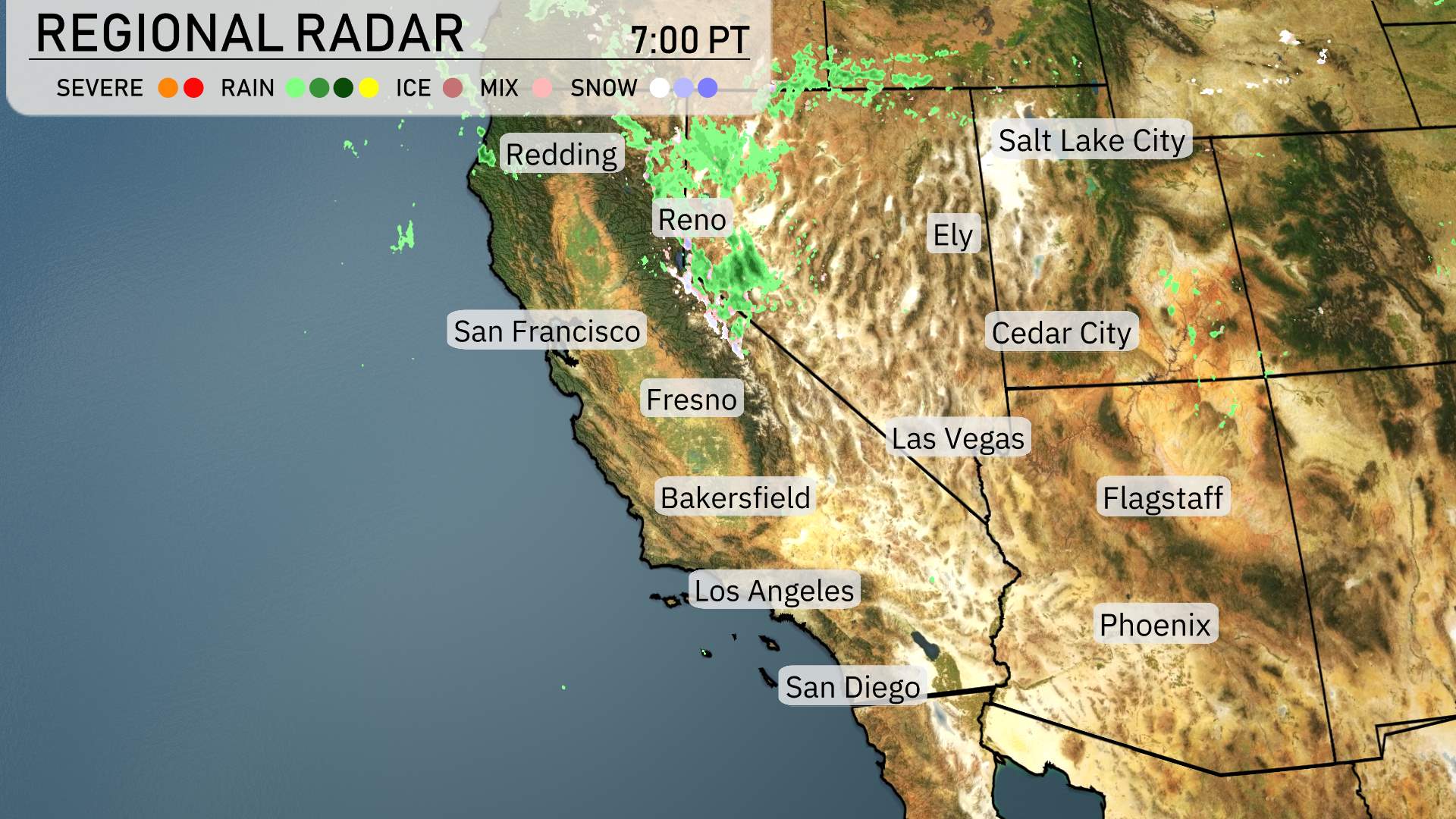
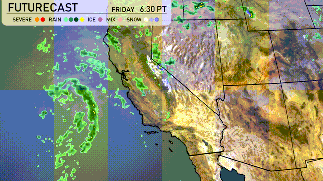
A line of showers is sweeping across Northern California, stretching from Redding and extending over the Sierra Nevada range. Reno is experiencing light rain, which will soon transition as the system moves eastward. Ely, along with the surrounding areas of eastern Nevada, is also seeing some precipitation. The skies over San Francisco down to Los Angeles and San Diego remain mostly clear, offering a reprieve from wet conditions. Flagstaff is likely to get some cloud cover as the day progresses, but it’s mostly calm in the Southwest.
In Salt Lake City this evening, expect mostly cloudy skies with an initial temperature of 71 degrees at 8 PM, cooling to 62 degrees by midnight. Winds will shift slightly from south to southeast, ranging from 10 to 8 miles per hour.
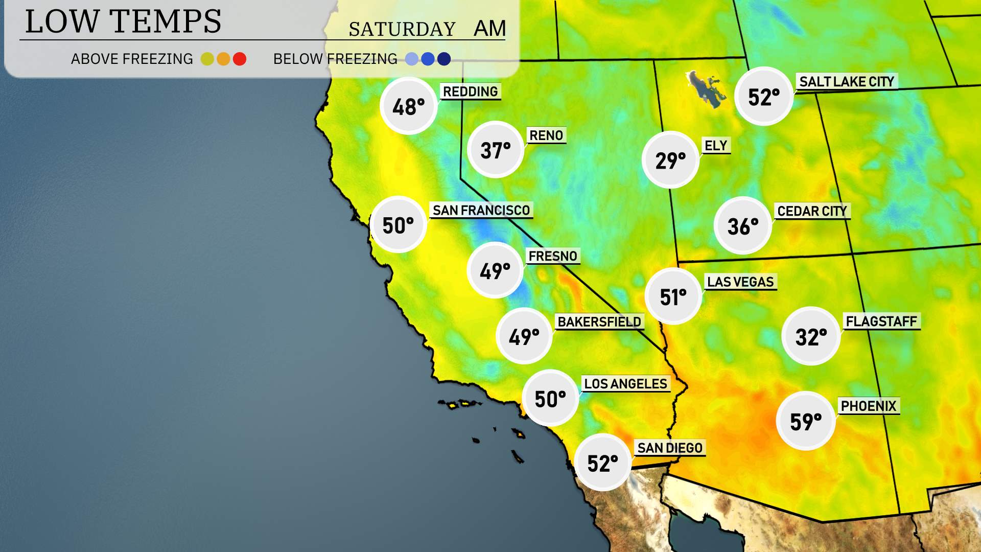
Low temperatures in the Southwest tonight will be quite chilly, with Flagstaff expecting a frigid 32 degrees. Ely is even colder at a sharp 29 degrees, signaling a notable drop in temperatures. Las Vegas will see a low of 51 degrees, while Phoenix stays relatively mild at 59 degrees. Over in Fresno, residents can expect 49 degrees, with San Francisco slightly warmer at 50 degrees. Bakersfield will match Fresno with an expected low of 49 degrees.
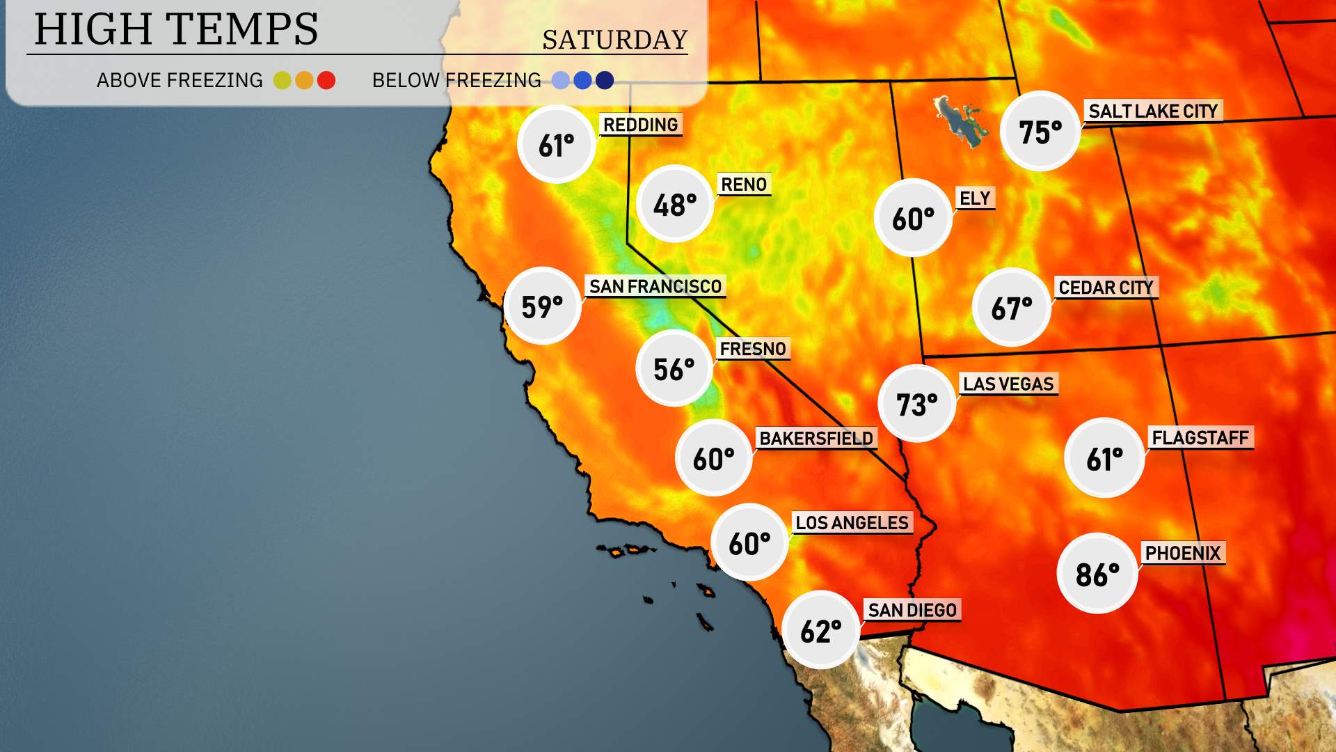
Phoenix will hit a sizzling 86 degrees, while Las Vegas reaches a comfortable 73. Los Angeles and San Diego are also expecting highs of 60 and 62 degrees, respectively. Inland, Bakersfield will see a high of 60 degrees, and Fresno is likely to warm up to 56 degrees. Redding could see a high of 61, underlining a trend of warmer conditions across the region.
A high-pressure system maintains dry and sunny conditions across Arizona and New Mexico, while Southern California deals with scattered showers. A weather system is progressing over the Pacific towards Northern California, promising moderate to heavy rain late Friday and into Saturday, enhancing the risk of localized flooding. An influx of cooler air accompanies the precipitation, with temperatures dipping several degrees below seasonal averages. Expect increased cloud cover and potential for slick roads, especially across higher elevations in the Sierra Nevada.
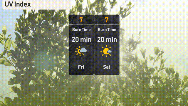
Salt Lake City’s UV index is high at 7 for both Friday and Saturday. Expect a burn time of about 20 minutes when exposed to direct sunlight.
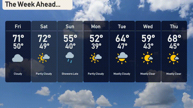
For the 7-day forecast in Salt Lake City:
Friday: Cloudy conditions with a high of 71 degrees, cooling to 50 degrees overnight.
Saturday: Partly cloudy skies and a warmer day with a high of 72 degrees and a low of 49.
Sunday: Expect showers late in the day, with temperatures reaching a high of 55 and a midnight chill of 40 degrees.
Monday: Partly cloudy skies dominate, as we see a high of 52 degrees and lows of 39.
Tuesday: Mostly clear day with temperatures rising to 64 degrees and a night low of 47.
Wednesday: The skies remain mostly clear as temperatures are set to hit 59 degrees, dropping to 43 for the low.
Thursday: A lovely day with mostly clear conditions, a high of 68 degrees, and an evening low of 45.