Miami Evenings & Southeast Storms: A Meteorologist’s Eye on the Weather
By
Amy Freeze
Explore the contrasts of serene Miami evenings against the backdrop of impending storms in the Southeast with Meteorologist Amy Freeze.
As evening falls over Miami, the city boasts calm skies while parts of the Southeast brace for storms. Join Amy Freeze for a comprehensive forecast.
In Miami, the evenings evoke a sense of mystery under partly cloudy skies, while a storm line makes its way from Jackson to Atlanta, impacting several cities with heavy rains and potential flood warnings. Temperatures remain warm across the region, adding to the dynamic weather conditions. Check out our detailed analysis and safety tips as we monitor these evolving patterns.
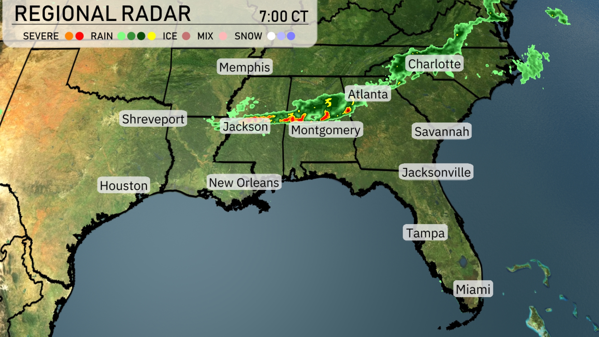
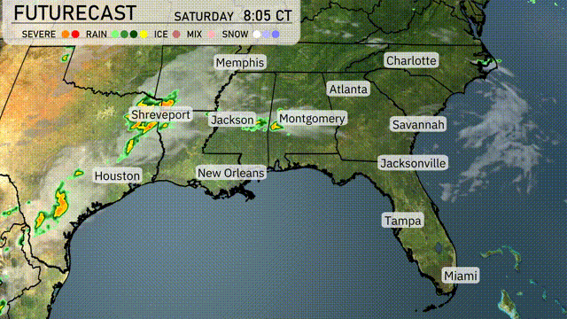
On the Regional Radar, a line of storms is traversing from Jackson, towards Atlanta. These active cells are delivering heavy rain and potential severe weather, particularly impacting Montgomery and Atlanta with clouds ahead of the storms moving into these areas. The rain band is making its way northeast and promises wet conditions into the evening for the Carolinas. Cities like Houston, New Orleans, and Memphis are currently enjoying clear skies with no rain in sight. Coastal cities such as Tampa and Miami remain free from any significant weather, maintaining their generally fair conditions.
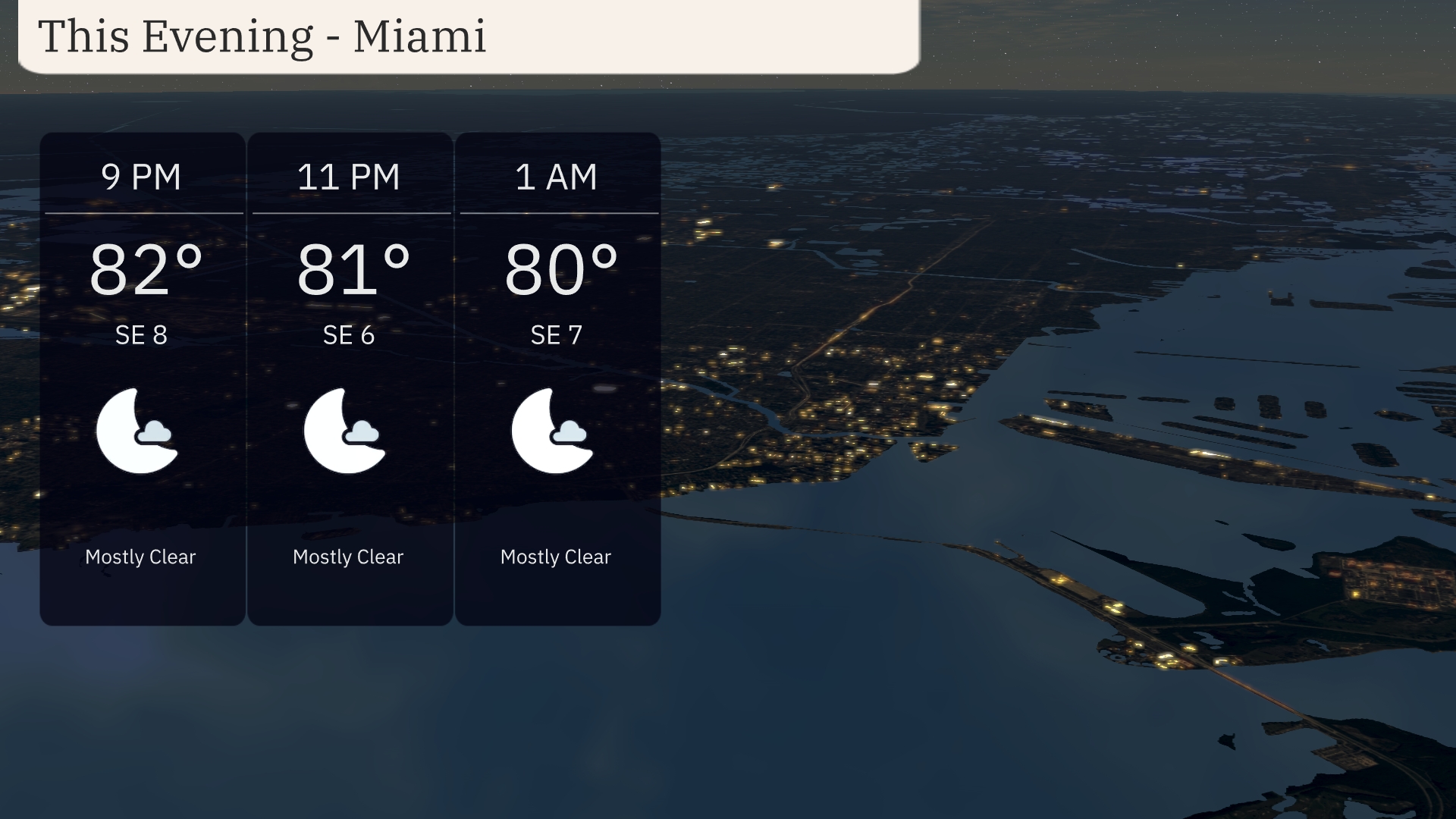
Miami’s evening forecast features warm temperatures, holding steady from 82 degrees at 9 PM to 80 degrees by 1 AM. Expect mostly clear skies throughout the evening with a gentle southeast wind ranging from 6 to 8 miles per hour.
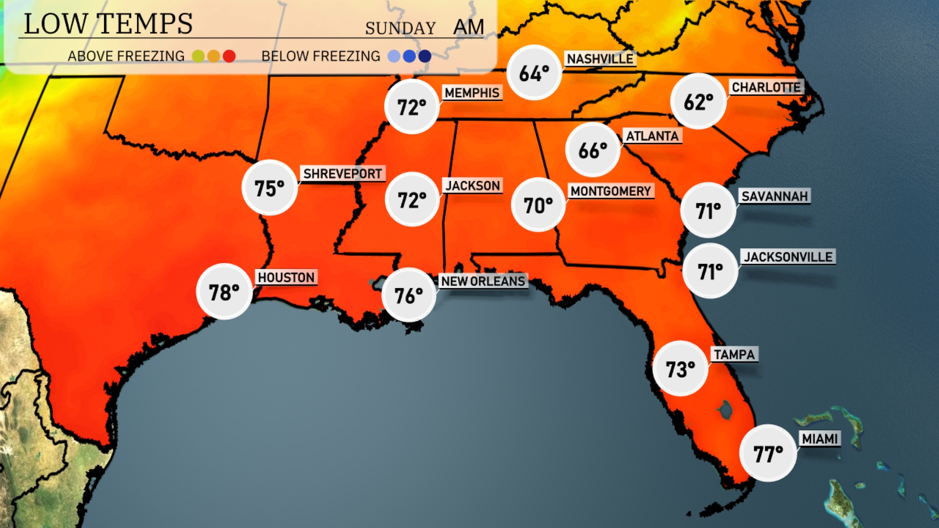
Tonight Memphis will see a low of 72 degrees, while Jackson drops to 72 as well. Shreveport is expected to cool slightly to 75 degrees, and New Orleans will rest at 76. Atlanta will have a cooler night with a low of 66 degrees. In contrast, Miami will remain warm at 77 degrees.
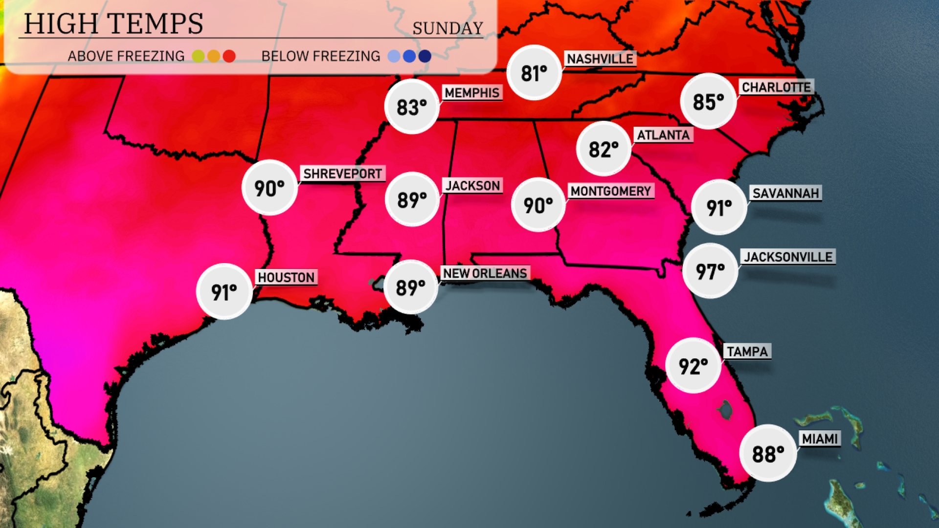
In the Southeast tomorrow Atlanta will reach 82 degrees, while Montgomery hits 90. Jacksonville is set to sizzle at 97 degrees, and Tampa will see a high of 92. New Orleans and Shreveport are both forecasted to be 89 degrees. This warm trend is driven by high pressure settling over the region, bringing clear skies and ample sunshine.
A dynamic weather pattern will affect the Southeast tomorrow. A cold front will push through, bringing showers and thunderstorms from Shreveport to New Orleans, impacting areas like Jackson and Montgomery. There’s potential for localized heavy rain, which may result in isolated flooding, so stay alert. Moderate temperatures are expected, with warm and humid conditions ahead of the front transitioning to cooler air behind it. Expect improving conditions mid-week as drier air moves in.
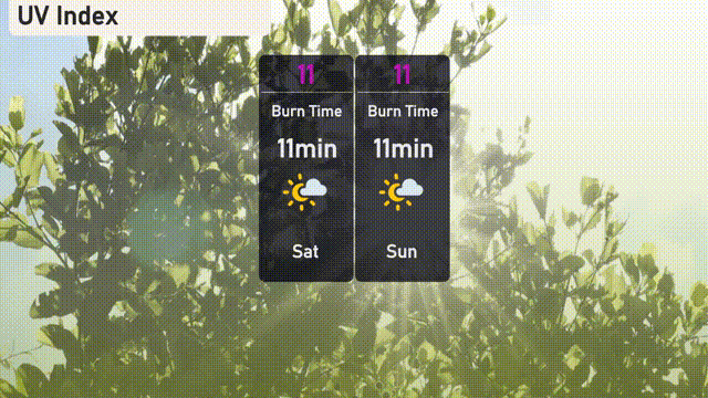
The UV index in Miami is very high at 11 both Saturday and Sunday, with a burn time of just 11 minutes in direct sunlight.
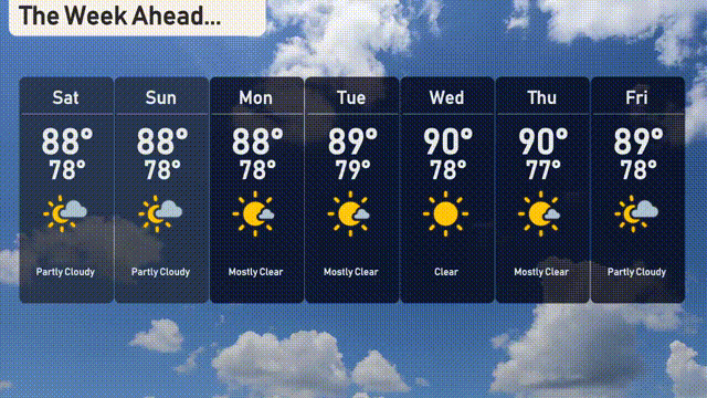
Saturday: Partly cloudy skies with a high of 88 degrees and a low of 78.
Sunday: Another partly cloudy day, maintaining a high of 88 degrees and a low of 78.
Monday: Skies clear up as we expect mostly clear conditions with a high of 88 degrees and a comfortable low of 79.
Tuesday: Mostly clear weather continues, with a slight increase in temperature to a high of 89 degrees and a low of 79.
Wednesday: Clear and warmer, as the thermometer hits 90 degrees for the high, cooling to 78 overnight.
Thursday: Consistently clear with temperatures reaching a high of 90 degrees and a night-time low of 77.
Friday: Partly cloudy, with the high around 89 degrees and a low of 78 to end the week.