Midwest in the Midst of Mayhem: Amy Freeze on the Severe Weather Frontline
By
Amy Freeze
As severe weather sweeps across the Midwest, Meteorologist Amy Freeze provides an in-depth look at the tumultuous climate changes, from powerful tornados to heavy showers. Stay ahead of the storm with crucial updates and insights.
Meteorologist Amy Freeze tracks a powerful line of storms across the Midwest. Discover key updates and safety advice amidst these severe weather conditions.
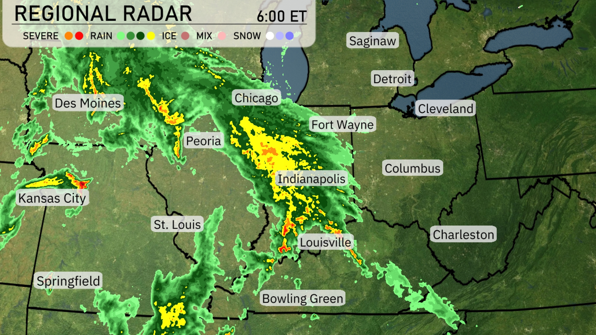
Join Meteorologist Amy Freeze as she guides us through a severe weather day expected across the Midwest, including cities like Chicago, Indianapolis, and St. Louis. With a detailed forecast and safety tips, this post provides everything you need to stay informed and prepared as storm fronts move across the region.
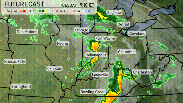
A strong line of storms is sweeping across areas from Des Moines eastward towards Chicago, with Indianapolis seeing intense precipitation. There is an increased threat for severe weather this afternoon, mainly south of the Kankakee River. All severe hazards, including amfew tornadoes, are possible.Louisville and Fort Wayne are in the path of significant rainfall. Heads up from Cleveland to Columbus where precipitation approaching.
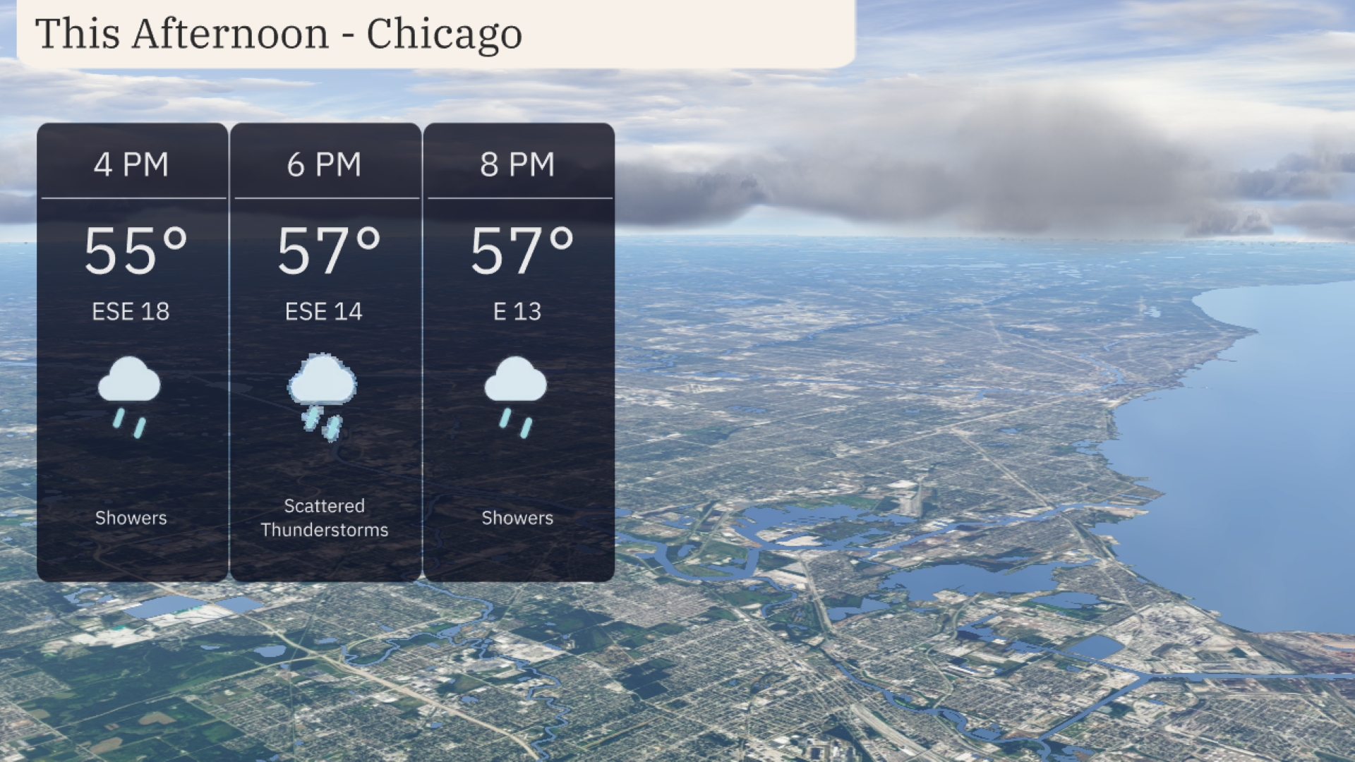
This afternoon in Chicago, temperatures will reach 55 degrees at 4 PM, with winds from the east-southeast at 18 miles per hour. Expect showers, transitioning to scattered thunderstorms by 6 PM as temperatures rise slightly to 57 degrees. Winds will ease to 14 miles per hour, shifting to an easterly direction at 8 PM, while temperatures hold steady at 57 degrees with continued showers.
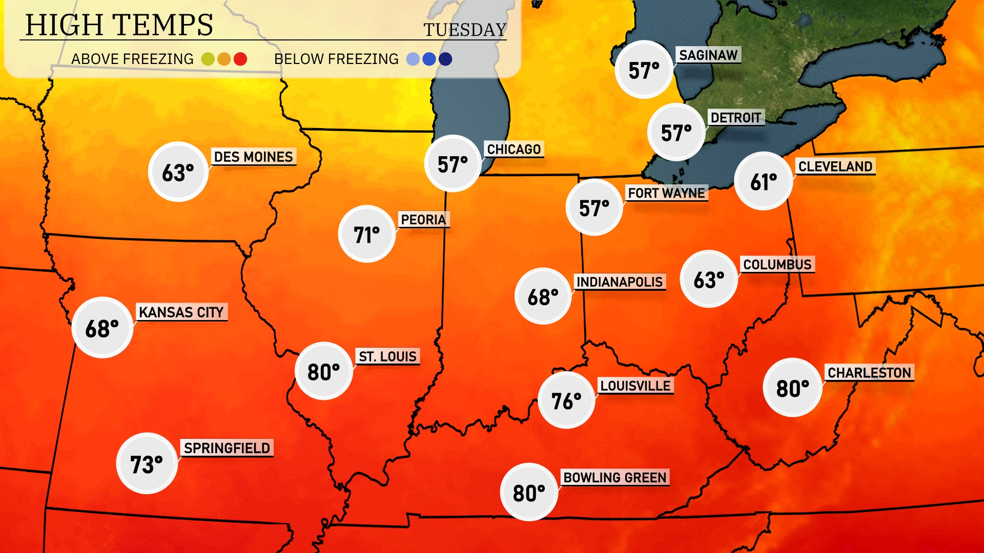
Today Chicago reache 57 degrees, while Indianapolis is forecasted for 68 degrees. Over in St. Louis, it’s a warmer day with a high of 80 degrees, the same as Bowling Green and Charleston. Peoria is warm as well, with highs hitting 71 degrees. Kansas City is mild at 68 degrees.
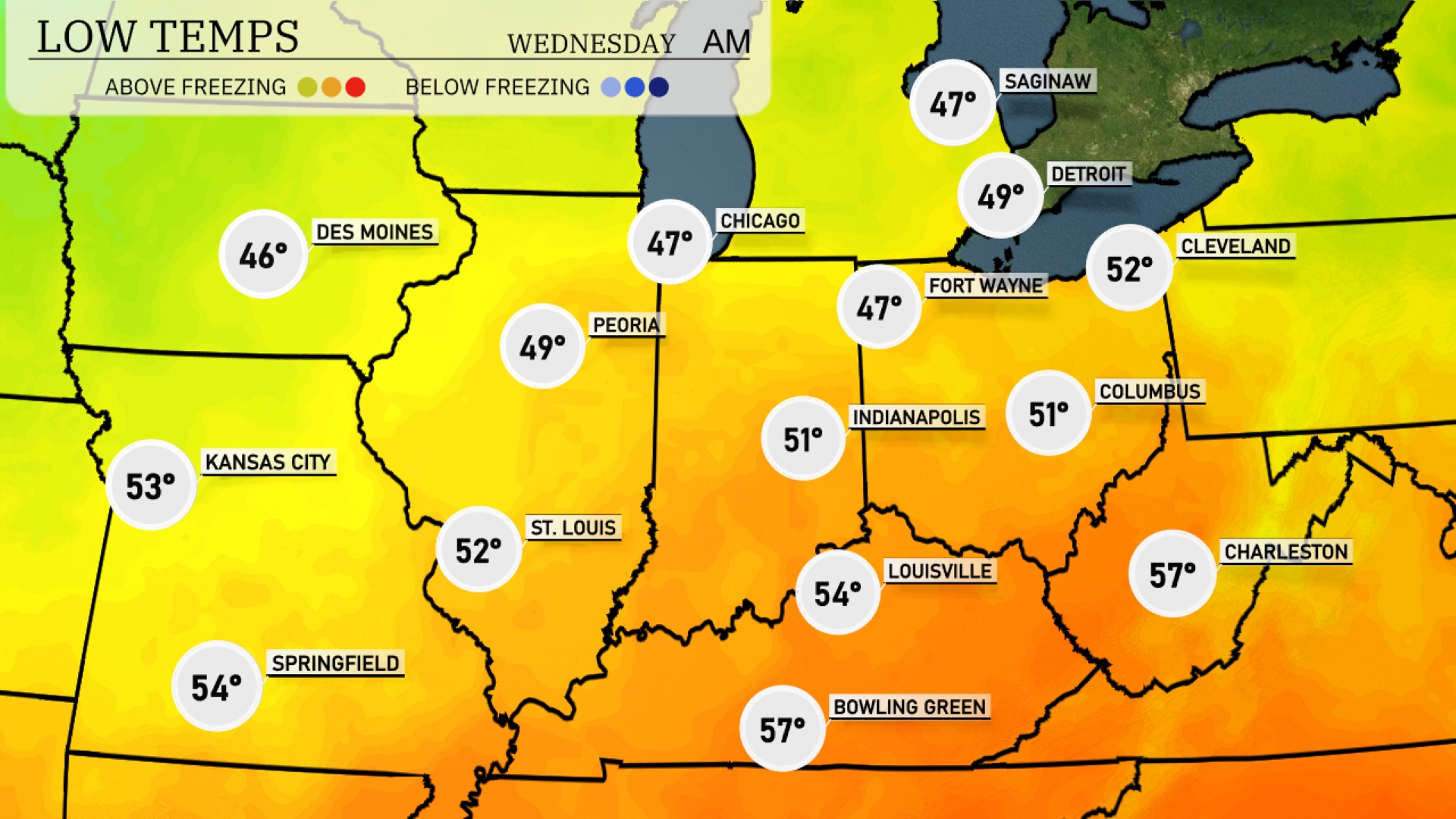
Tonight Chicago and Indianapolis will see lows of 47 degrees, while Peoria will drops to 49. A chilly night is on the way for Des Moines, with temperatures expected to hit 46 degrees. In St. Louis, the forecast calls for a milder 52 degrees. Expect a low of 54 in Kansas City, marking a temperature drop from recent warmer trends.
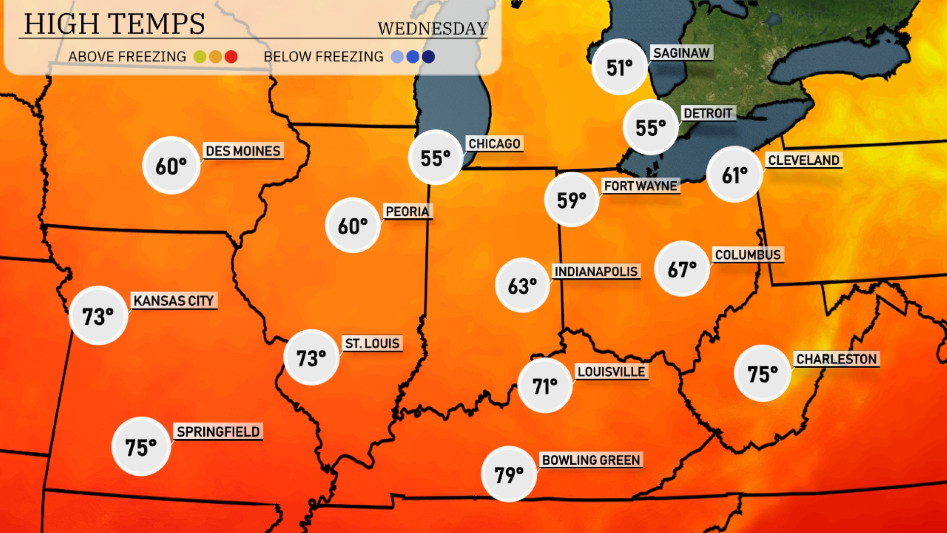
For tomorrow, the Midwest is experiencing above-average high temperatures, marking a warm start to the week. St. Louis leads the charge with a high of 73 degrees, while Kansas City and Springfield also match at 73 degrees. Indianapolis is expected to see a high of 63 degrees, with Louisville slightly warmer at 71 degrees. Chicago will remain cooler at 55 degrees, and Fort Wayne will peak at 59 degrees. The warm air mass moving through the region is contributing to these elevated temperatures.
A low-pressure system will move through the Midwest, bringing showers and thunderstorms from Chicago to Indianapolis by midday. Expect heavy downpours with a risk of gusty winds, particularly around the Fort Wayne and Louisville areas. Temperatures will remain moderate, with highs in the mid-70s. Areas like Detroit and Columbus should anticipate rain into the evening. The system exits by late Wednesday, leaving cooler, drier conditions in its wake.
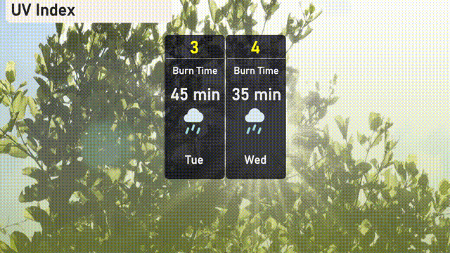
The UV index in Chicago will be low on Tuesday with a value of 3, and on Wednesday it reaches 4.