Sunny Days and Sudden Storms: Salt Lake City’s Weather Rollercoaster
By
Amy Freeze
Discover how Salt Lake City is bracing for a week of weather extremes, from balmy afternoons to unexpected snow and stormy forecasts.
Dive into this week’s Salt Lake City weather report with Amy Freeze. Expect everything from sunny days to potential storms. Read on for daily breakdowns and expert insights!
Greetings from Meteorologist Amy Freeze with your detailed weather forecast for Salt Lake City. This week, embrace a whirlwind of weather patterns – sunny days, unexpected snowfalls, and possible thunderstorms on the horizon. Each day brings new weather adventures! From mild afternoons to chilly nights and a significant cooling trend propelled by an incoming cold front, be prepared for anything. Don’t forget to stay sun-safe with the UV index peaking, and catch all subtleties of the shifting skies over Salt Lake City. Full forecast details are available on https://amyfreeze.ai/
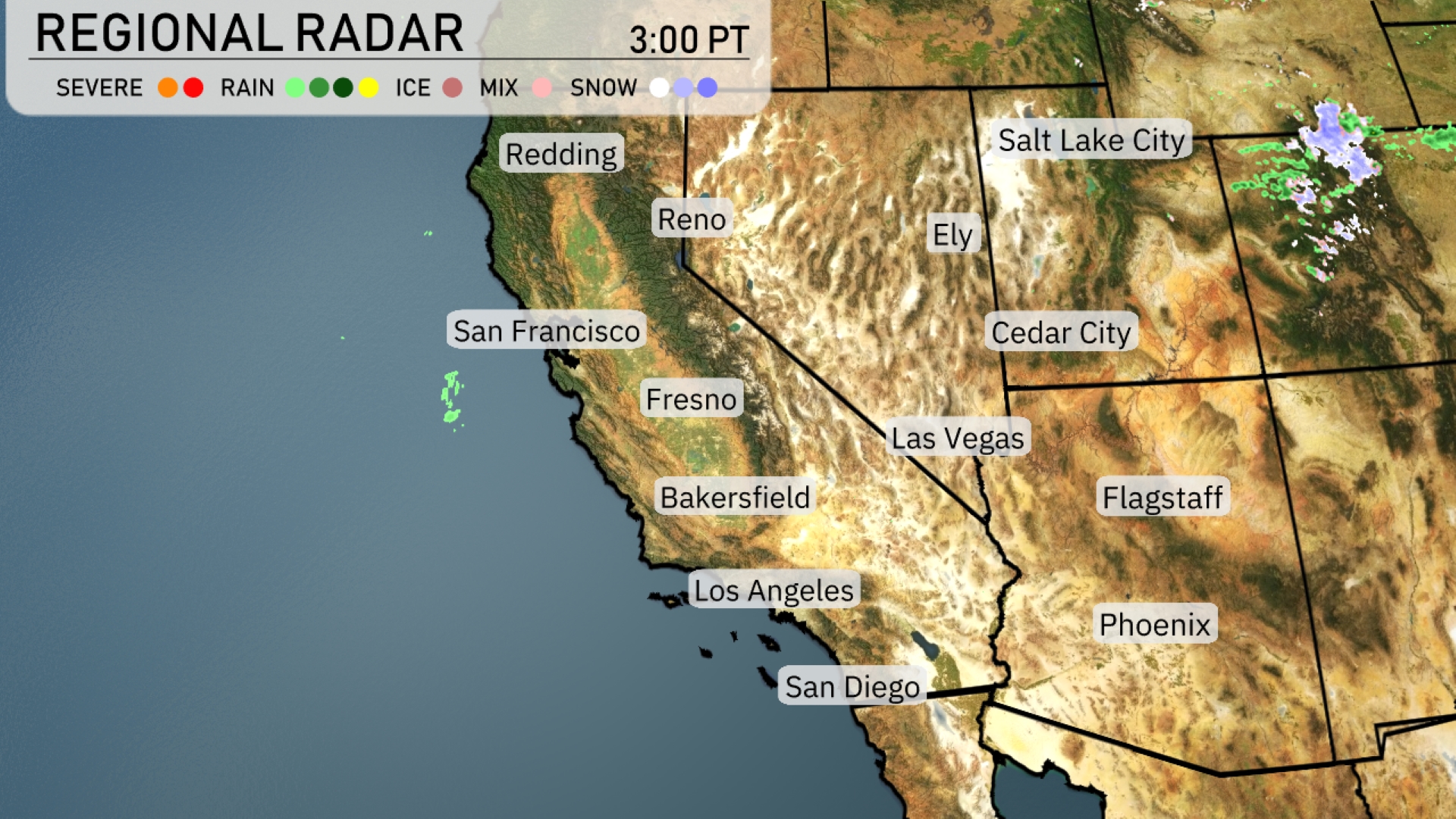
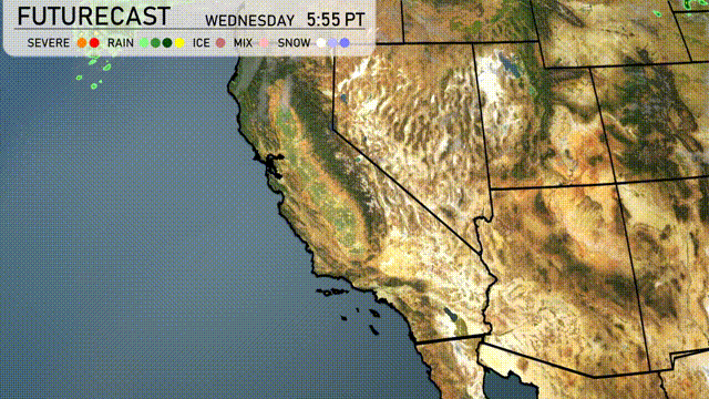
Over the Southwest, the regional radar shows a mainly calm weather pattern prevailing. A few light rain showers are detected off the coast of San Francisco, while Reno and Las Vegas remain dry and clear under sunny skies. Snowfall is spotted just north of Ely, expected to bring snowflakes to Salt Lake City. Cities like Fresno and Phoenix are enjoying clear and dry conditions. Slight cloud cover is seen in areas like Flagstaff, but no precipitation is present at this time.
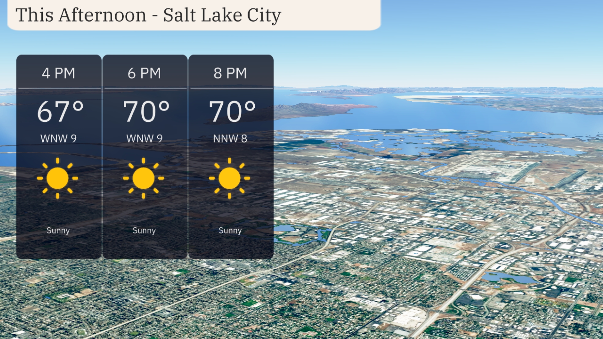
This afternoon in Salt Lake City, enjoy sunny skies with temperatures rising to 70 degrees by 6 PM. Winds will be coming from the west-northwest at 9 miles per hour, providing a gentle breeze. By 8 PM, temperatures remain steady at 70 degrees with a slight decrease in wind speed to 8 miles per hour.
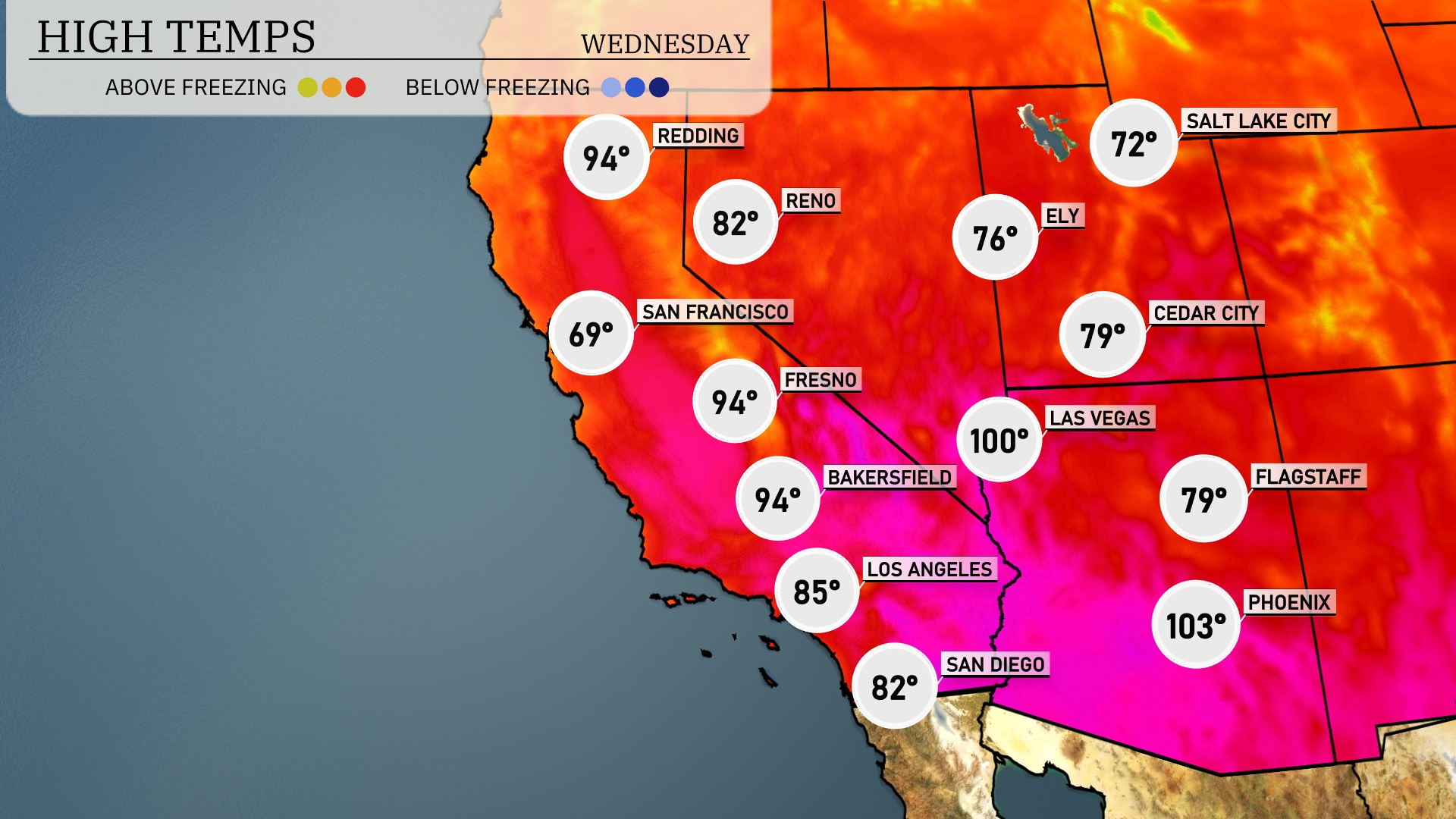
Today in the Southwest, we’re seeing some significant warmth across the region. Las Vegas is hitting a scorching high of 100 degrees, while nearby Phoenix is not far behind at a sizzling 103 degrees. In California, Bakersfield and Fresno both reach a high of 94 degrees, providing a warm contrast to the coastal temperatures, with San Diego staying cooler at 82 degrees. Farther north in the region, Reno is at 82 degrees, while Salt Lake City experiences a mild day at 72 degrees.
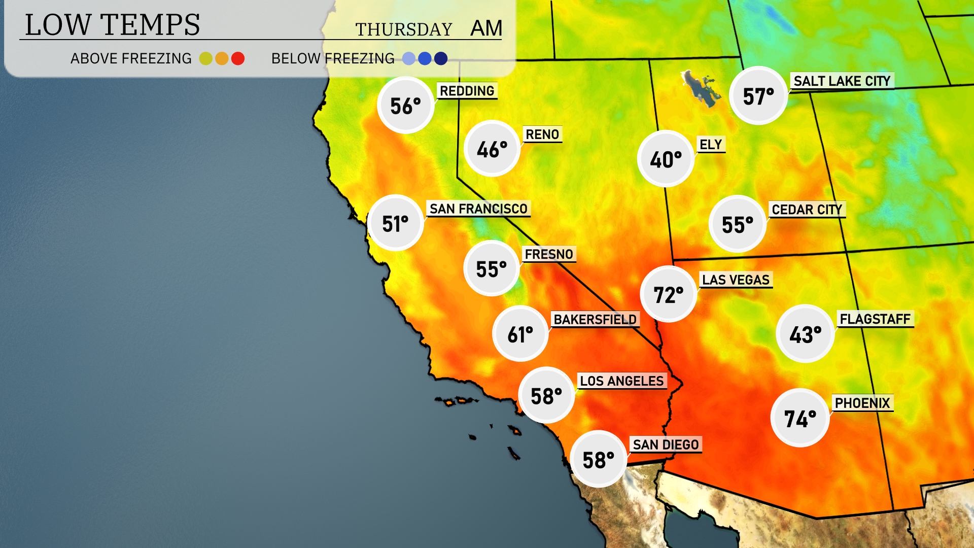
Tonight’s low temperatures in the Southwest reveal a chilly trend, particularly in higher elevation areas. Flagstaff is forecast to dip to a brisk 43 degrees, while Ely will be even cooler at 40. Las Vegas remains relatively mild with a low of 72, but further west, San Francisco experiences a cooler 51. Cities like Fresno and Bakersfield will see lows of 55 and 61 degrees respectively, presenting a noticeable drop from recent warmer nights.
High temperatures in the Southwest tomorrow are significantly above average, contributing to a warm and dry pattern. Las Vegas will soar to 101 degrees, while Phoenix is expected to hit a scorching 106 degrees. Further west, Bakersfield will reach 94 degrees and Fresno sees a high of 93. In contrast, coastal cities like San Diego will warm up to 77 degrees and Los Angeles will enjoy a high of 81 degrees.
A cold front will push into the Southwest tomorrow, bringing a noticeable cooling trend and a chance for scattered thunderstorms across Arizona and New Mexico by late afternoon. Expect strong wind gusts accompanying these storms, which could lead to isolated power outages. Areas in southern Utah and Nevada should prepare for heavy rain, potentially causing flash flooding in low-lying regions. Daytime temperatures will drop significantly, with highs in the mid-70s, a stark contrast from today’s heat.
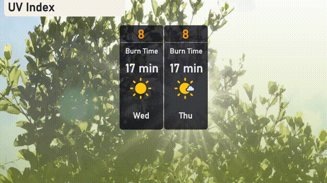
The UV index in Salt Lake City is very high, reaching 8 today and tomorrow. Be cautious as sunburn can occur in just 17 minutes of direct exposure.