Midwest Mosaic: Chicago’s Dynamic Week Ahead in Weather
By
Amy Freeze
Dive into a detailed forecast with Meteorologist Amy Freeze as she outlines the shifting skies from peaceful to tempestuous across the Midwest.
This week’s Midwest forecast brings a spectrum of weather from serene skies in Chicago to potential storms across the region. Learn what to expect with Amy Freeze!
Welcome to your detailed forecast update with Meteorologist Amy Freeze. From partly cloudy skies in Chicago to a looming line of rain stretching from Kansas City to St. Louis, understand the upcoming weather changes. Tune in for daily updates as conditions evolve, and prepare for the week’s weather with insightful, professional analysis.
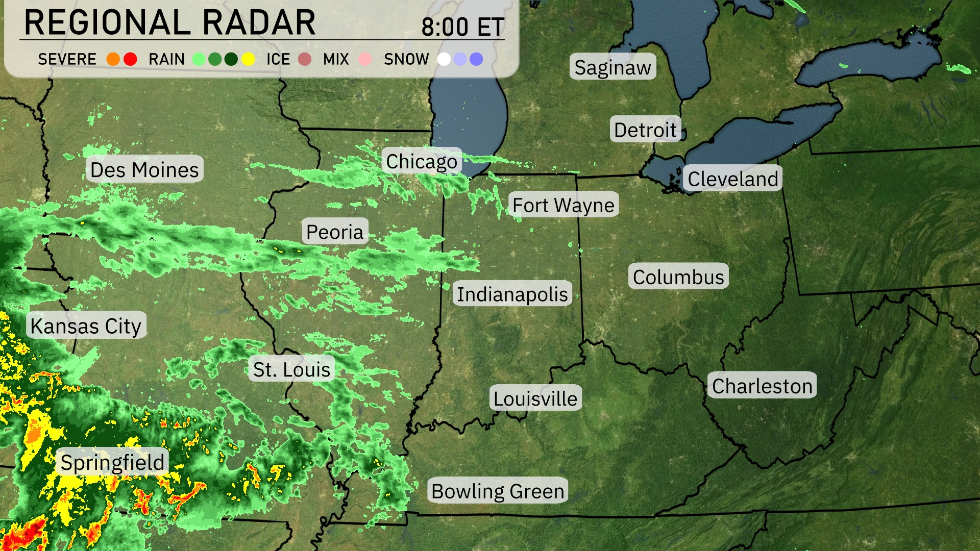
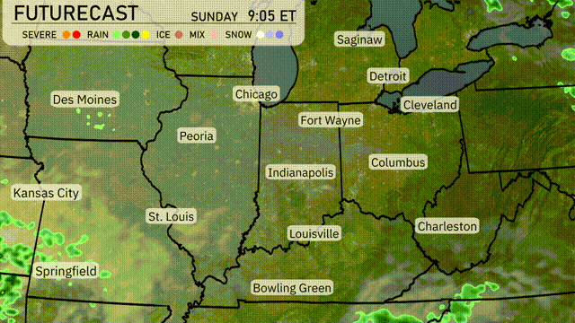
A dynamic weather system is unfolding in the Midwest, with a line of rain stretching from Kansas City to St. Louis, moving steadily northeast. This system will bring rain to Springfield and Peoria, with more intense precipitation spreading towards Indianapolis and Fort Wayne. Cities such as Chicago and Detroit are beginning to see increasing cloud cover, hinting at wet conditions to follow. As the rain makes its way closer, areas around Des Moines and Bowling Green remain relatively calm for now. Farther east, expect clearer skies over areas like Cleveland and Charleston, with no immediate precipitation threats.
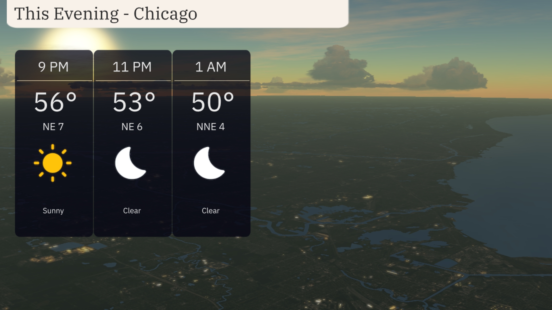
For this evening in Chicago, temperatures will gradually decline from 56 degrees at 9 PM to 50 degrees by 1 AM. Expect a clear evening with no clouds in sight. Wind conditions will be gentle, with a northeastern breeze around 7 miles per hour early in the evening, tapering to 4 miles per hour by midnight.
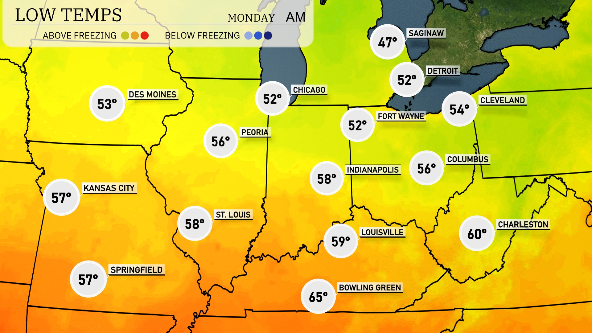
Tonight in the Midwest, expect cooler temperatures across the region. Chicago will see a low of 52 degrees, while temperatures dip to 47 in Saginaw, marking a significant drop. Indianapolis is forecasted for a low of 58 degrees, with Cleveland close behind at 54. Expect lows of 56 degrees in both Columbus and Peoria. St. Louis will remain slightly warmer at 58 degrees.
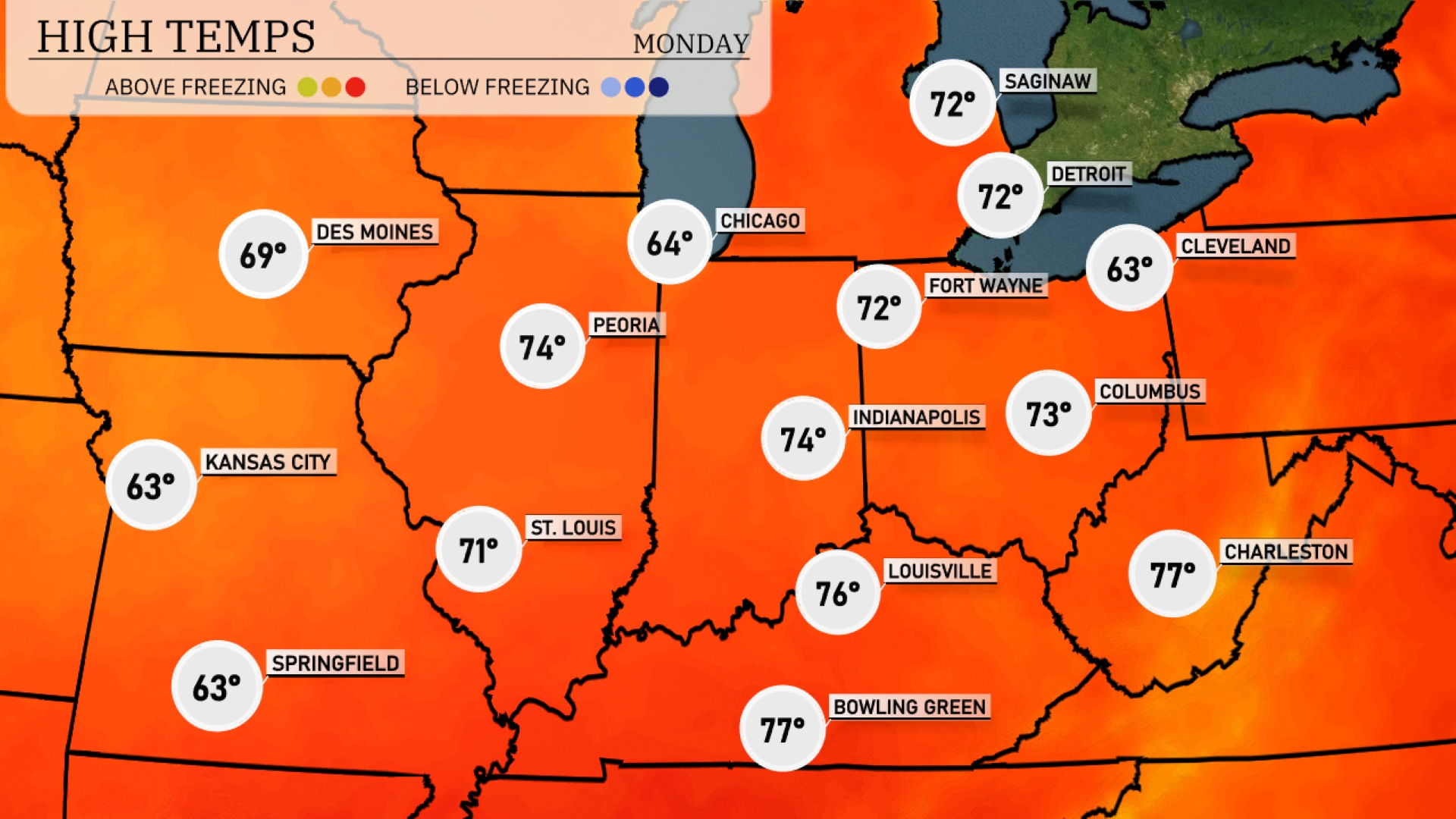
Tomorrow Chicago will reach 64 degrees, while Indianapolis enjoys a pleasant 74 degrees. Louisville is anticipating a warm 76 degrees, and Bowling Green could see temperatures rise to an impressive 77 degrees. However, Kansas City will cool down at just 63 degrees, which is below average for this time of year.
A cold front pushing through the Midwest tomorrow will bring significant weather shifts. Expect thunderstorms starting in Kansas City by noon, moving quickly towards St. Louis and Peoria through the afternoon, with the potential for gusty winds and hail. Rain will continue to spread northeast into Chicago and Fort Wayne by evening, which may cause localized flooding. Temperatures ahead of the front will remain warm, but look for a drop by about 10 degrees post-frontal passage.
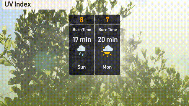
The UV index in Chicago is set to reach a high of 8 on Sunday, indicating a burn time of about 17 minutes in direct sunlight. By Monday, the UV index slightly decreases to 7, with a burn time of 20 minutes.
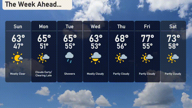
For the Chicago 7 day forecast
Sunday: Mostly clear skies with a high of 62 degrees, cooling to 47 degrees at night.
Monday: Expect cloudy conditions with temperatures reaching 65 degrees, and a low of 52 degrees.
Tuesday: Light rain moves in with a high of 64 degrees, dropping to 55 degrees overnight.
Wednesday: Mostly cloudy skies with periods of sunshine, as highs hit 62 degrees and lows of 53 degrees.
Thursday: Partly cloudy, a touch warmer with a high of 67 degrees and a nighttime low of 56 degrees.
Friday: The sun peeks through more as temperatures rise to 76 degrees, dipping to 55 degrees at night.
Saturday: Partly cloudy, rounding out the week with a high of 73 degrees and a low of 57 degrees.