Southern Plains Weather Alert: Storms, Sunshine, and Safety Tips
By
Amy Freeze
Explore an in-depth look at the severe weather impacting the Southern Plains, with insights from experienced meteorologist Amy Freeze. From storm safety to regional forecasts, stay ahead of the weather!
Experienced meteorologist Amy Freeze gives a rundown on the changing weather patterns across the Southern Plains. From severe storms to clear skies, get all the regional weather updates and tips for staying safe.
As a sprawling weather system moves across Southern Texas, Amy Freeze provides a detailed analysis of the impacts from Corpus Christi to Oklahoma City. Learn about the risks of hail, high winds, and tornadoes during this severe weather period. Additionally, get a 7-day forecast for Austin, safety tips for handling intense weather conditions, and information on how to protect yourself from the sun’s harmful rays. With temperatures and conditions varying across different cities, stay informed and prepared with our all-encompassing weather guide.
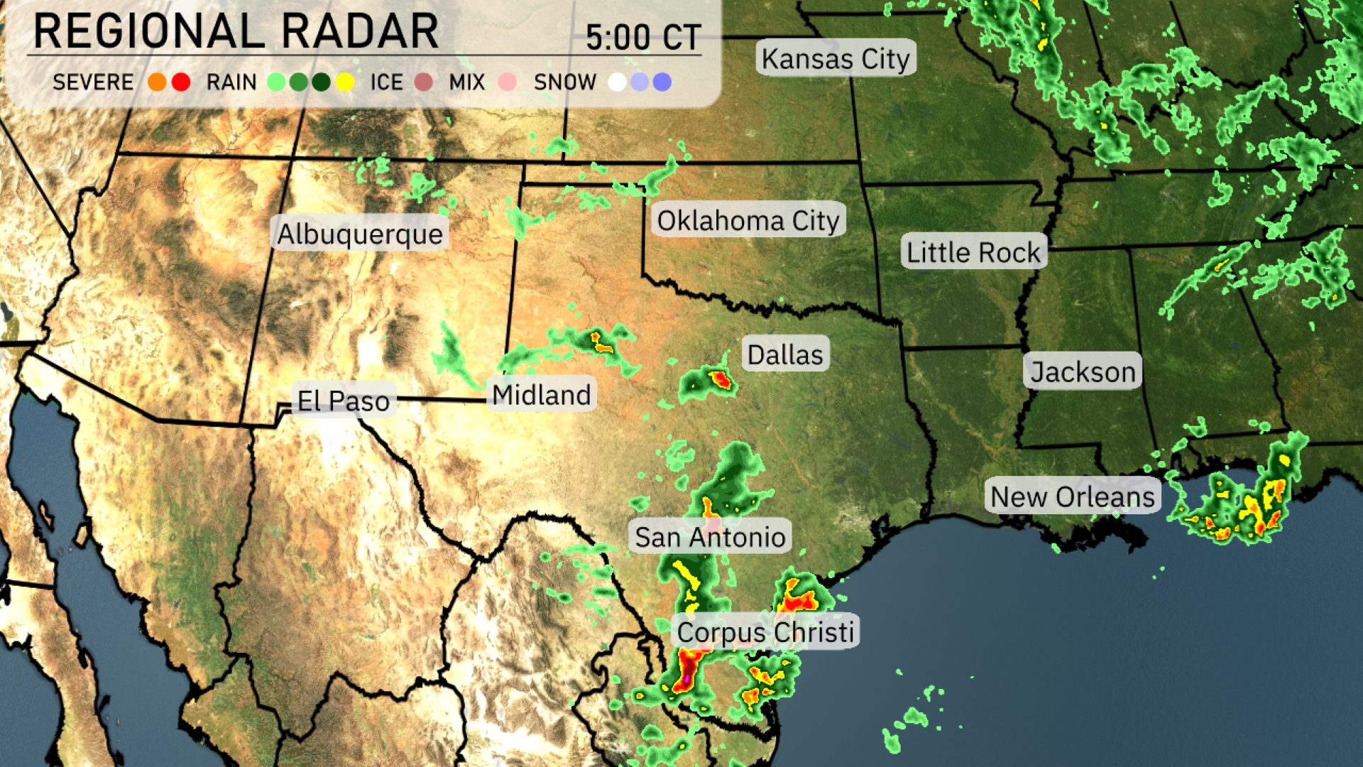
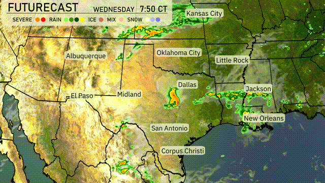
An active weather system is bringing severe storms to parts of Southern Texas, with intense activity near Corpus Christi and moving towards San Antonio. The storms are accompanied by heavy rain and are marching northeastward. Scattered showers extend into the Oklahoma City region, although conditions remain relatively dry further north towards Kansas City. Areas from Midland to El Paso are experiencing mostly clear skies. This weather system is likely to develop farther as it tracks eastward into the Mississippi Delta.
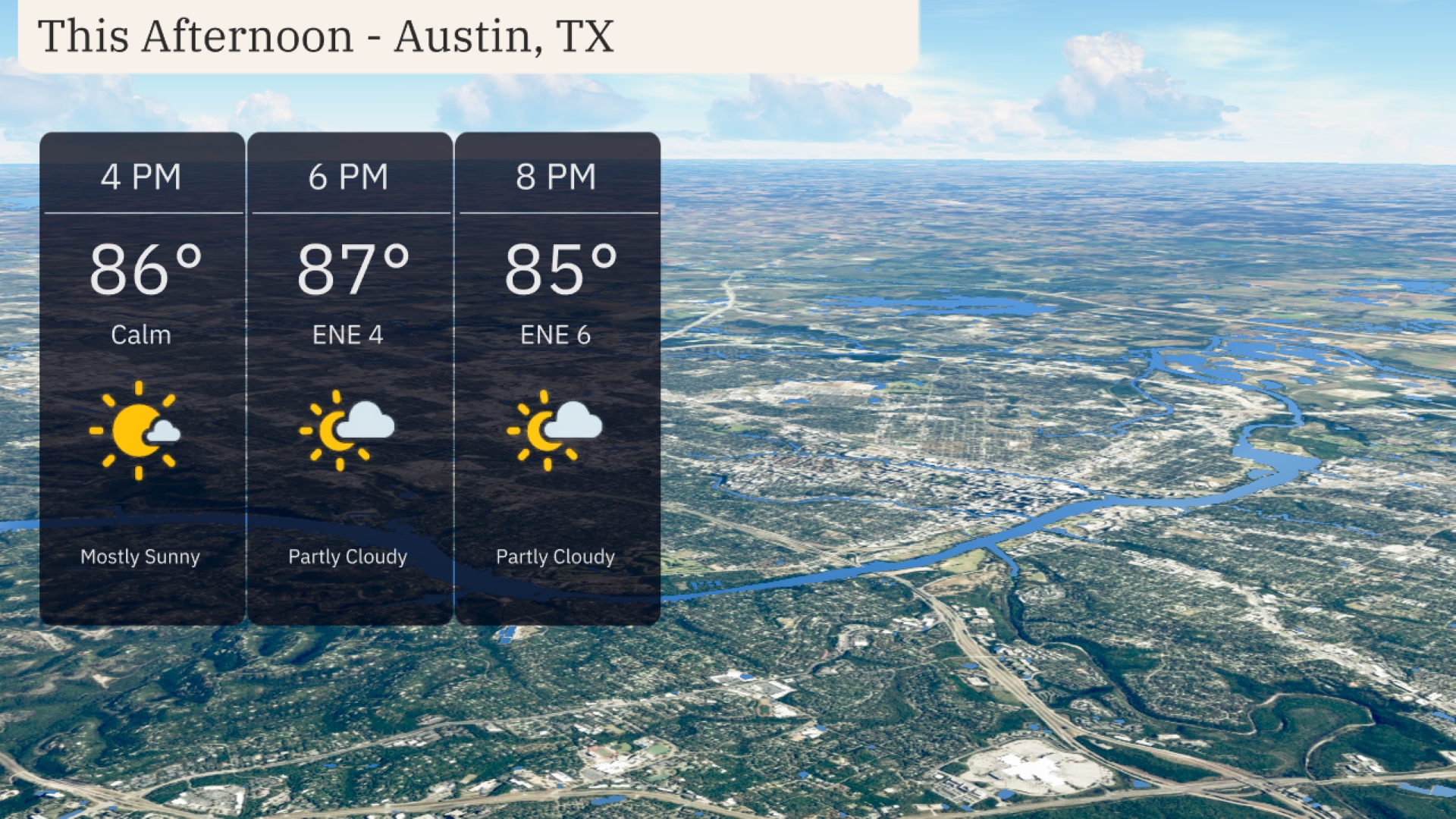
For this afternoon in Austin, expect mostly sunny skies with temperatures climbing to a warm 86 degrees by 4 PM. Winds are calm, transitioning to an east-northeast breeze at 4 miles per hour by 6 PM, when temperatures rise slightly to 87 degrees. By 8 PM, the sky turns partly cloudy, and temperatures gently cool down to 85 degrees with winds picking up to 6 miles per hour from the east-northeast.
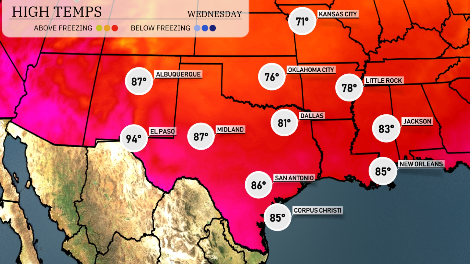
Today El Paso leads the pack with a high of 94 degrees, while Midland reaches 87. In Dallas, expect a pleasant afternoon with a high of 81 degrees. Moving east, Jackson and New Orleans are quite warm as well, both hitting 83 and 85 degrees respectively. San Antonio also enjoys a mild day at 86 degrees.
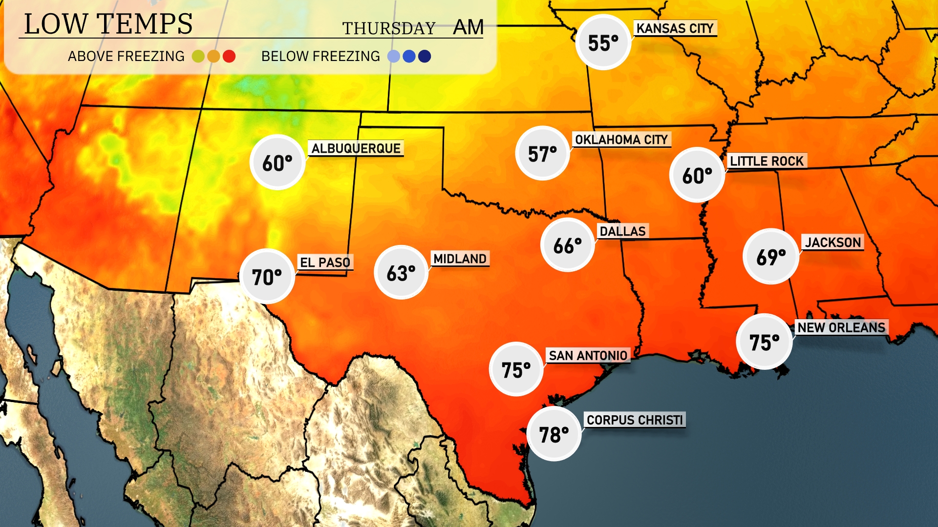
Tonight Oklahoma City is expected to drop to 57 degrees, while Dallas will see a low of 66. In contrast, Midland will cool to 63 degrees. San Antonio will hold onto warmer air with a low of 75 degrees.
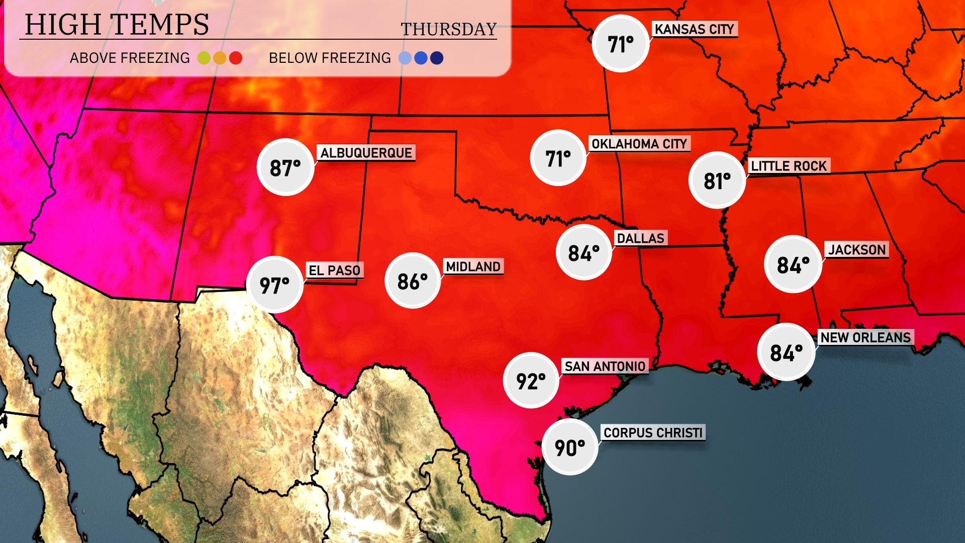
El Paso will hit a sizzling 97 degrees, while Midland reaches a comfortable 86 degrees. San Antonio is expected to warm up to 92, and Corpus Christi is forecasted for a high of 90. Dallas will see a bit of a cool-down, with a high of 84 degrees.
Severe thunderstorms are likely across the Southern Plains, particularly from Dallas to Oklahoma City, due to an advancing cold front. Hail, gusty winds, and isolated tornadoes are possible, so stay alert for weather warnings through Wednesday night. Rainfall will bring much-needed moisture from San Antonio to Corpus Christi, with localized flooding concerns due to heavy downpours. Temperatures will drop post-storm, offering cooler and dry conditions as we head towards the weekend.
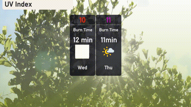
The UV index in Austin will be very high on Wednesday, hitting 10, with a burn time of about 12 minutes, so be sure to use ample sun protection. On Thursday, the index rises even higher to 11, reducing the burn time to just 11 minutes.