From Sunshine to Thunderstorms: Miami’s Week in Weather
By
Amy Freeze
Explore a week of weather in Miami with Meteorologist Amy Freeze as we encounter sunny skies, sudden thunderstorms, and everything in between for an unpredictable week ahead.
This week in Miami, the weather takes us on a roller coaster from partly cloudy skies and intense sunshine to thunderstorms and cooler nights. Stay tuned for daily updates with Amy Freeze!
Welcome to a detailed review of Miami’s weather this week with your trusted meteorologist, Amy Freeze. We’re starting with a beautiful sunny day perfect for beach strolls but as the week progresses, the region will face dynamic changes. From thunderstorms rolling in from the Gulf coast causing potential localized flooding to calm, clear nights – every day brings something new. Discover how these conditions could impact your week and get prepared by following our daily weather insights.
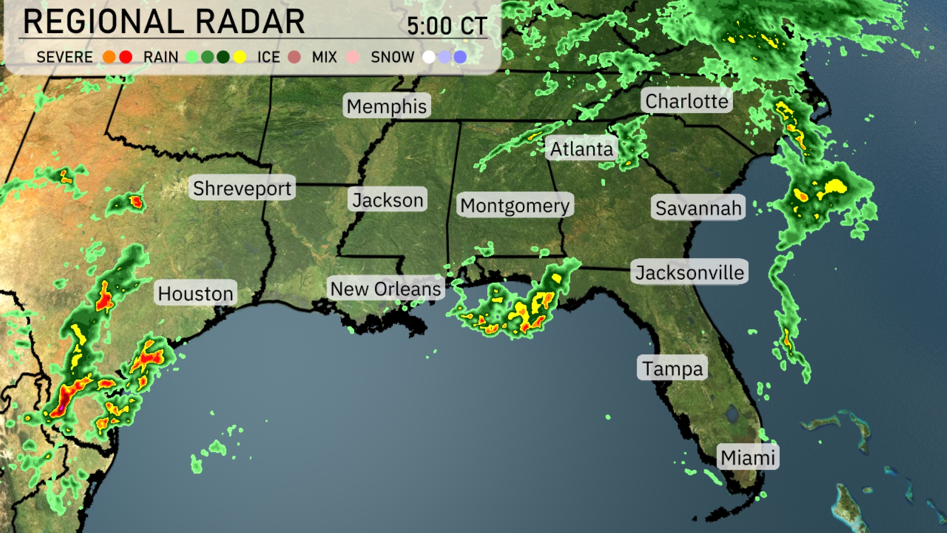
The Southeast is experiencing dynamic weather as rain showers move through the region. Areas from New Orleans to Jacksonville are seeing steady rain, while heavier thunderstorms are affecting parts of the Florida Panhandle. Up through Atlanta and Charlotte, light rain showers are present with increasing cloud cover. Houston and surrounding areas are anticipating stormy weather, with significant rain indicated on the radar. Along the Carolina coast, including Savannah, skies are mostly clear.
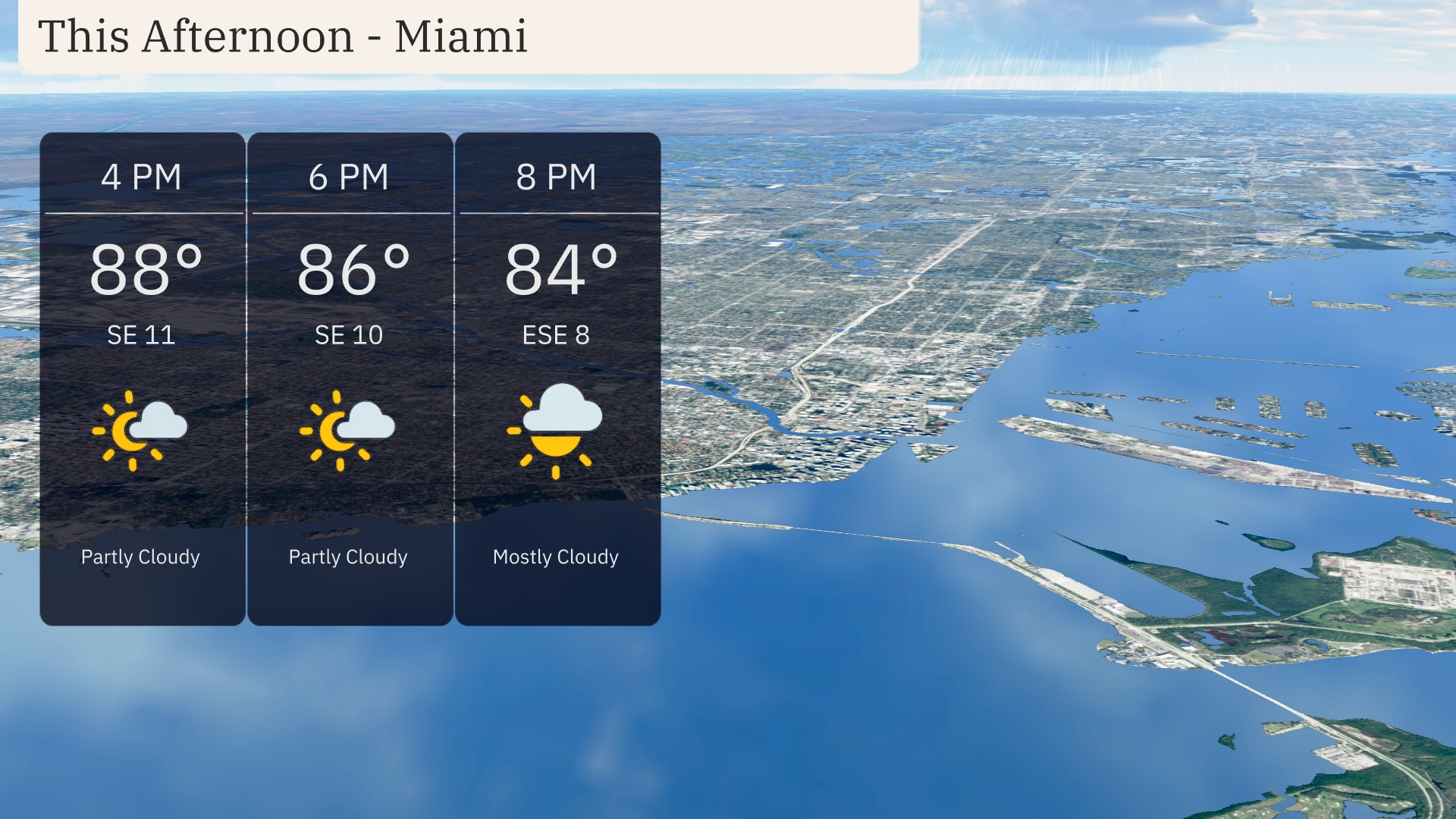
Temperatures in Miami this afternoon are starting at 88 degrees at 4 PM, cooling slightly to 86 degrees by 6 PM with a partly cloudy sky. Winds will be from the southeast at 11 miles per hour, shifting slightly to the east-southeast at 10 miles per hour. By 8 PM, expect temperatures to dip to 84 degrees under mostly cloudy conditions with a breeze coming from the east-southeast at 8 miles per hour.
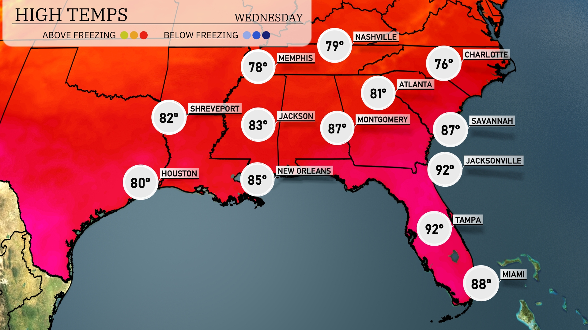
Today in Atlanta will reach a high of 81 degrees, while Montgomery is a bit warmer at 87 degrees. Over in Jacksonville, prepare for a sultry day with temperatures soaring to 92 degrees. Meanwhile, New Orleans will see a high of 85, providing a comfortable contrast to the rest of the region. Tampa also clocks in at 92 degrees, with Miami trailing closely at 88 degrees.
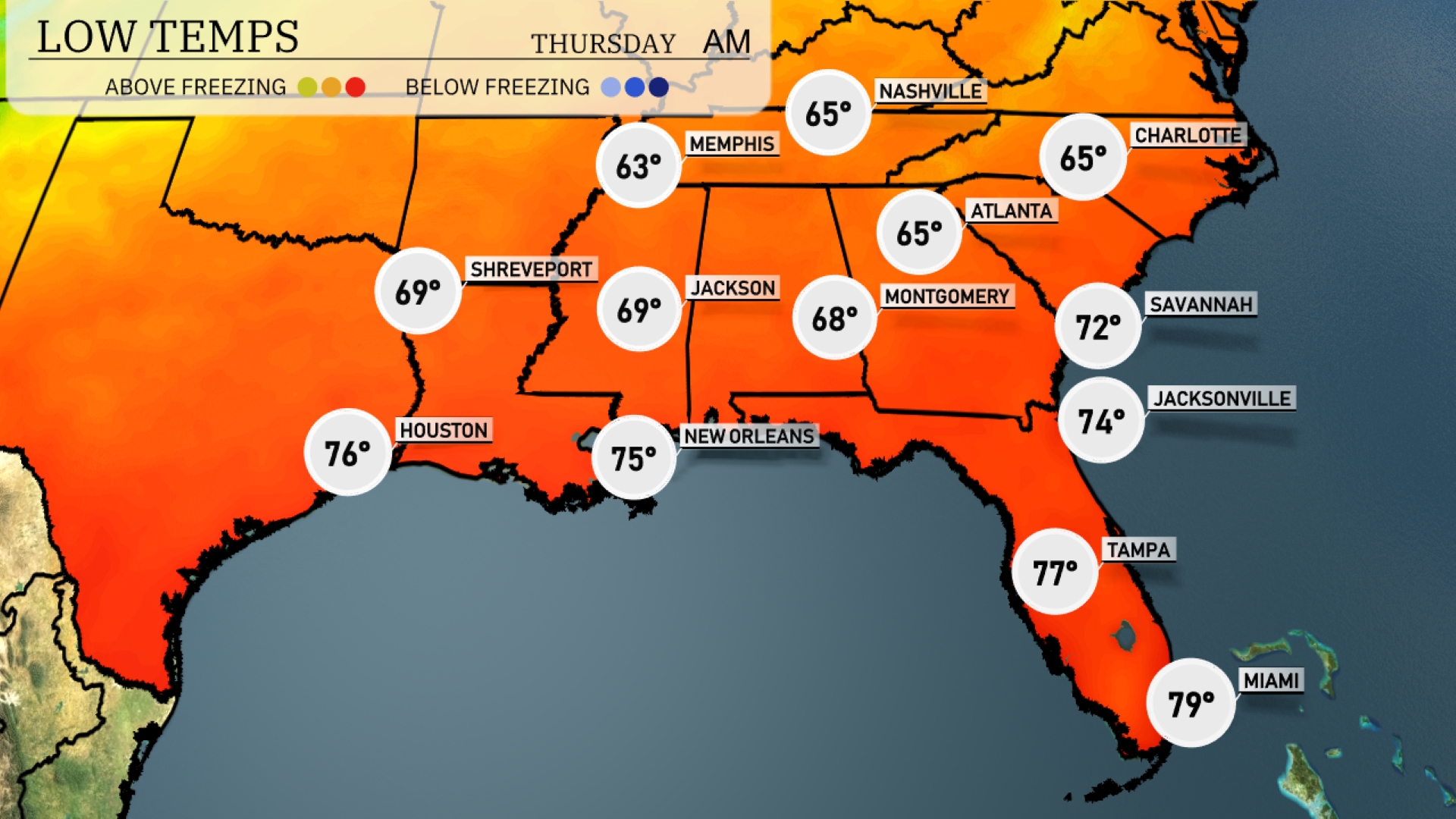
Tonight Memphis will cool down to 63 degrees, while Nashville won’t be far behind at 65. Atlanta is also looking at a mild low of 65 degrees. Expect Jackson to dip to 69, and Shreveport will pleasantly rest at 69 as well. New Orleans stays warmer at 75 degrees, ensuring a mild night across the Gulf Coast.
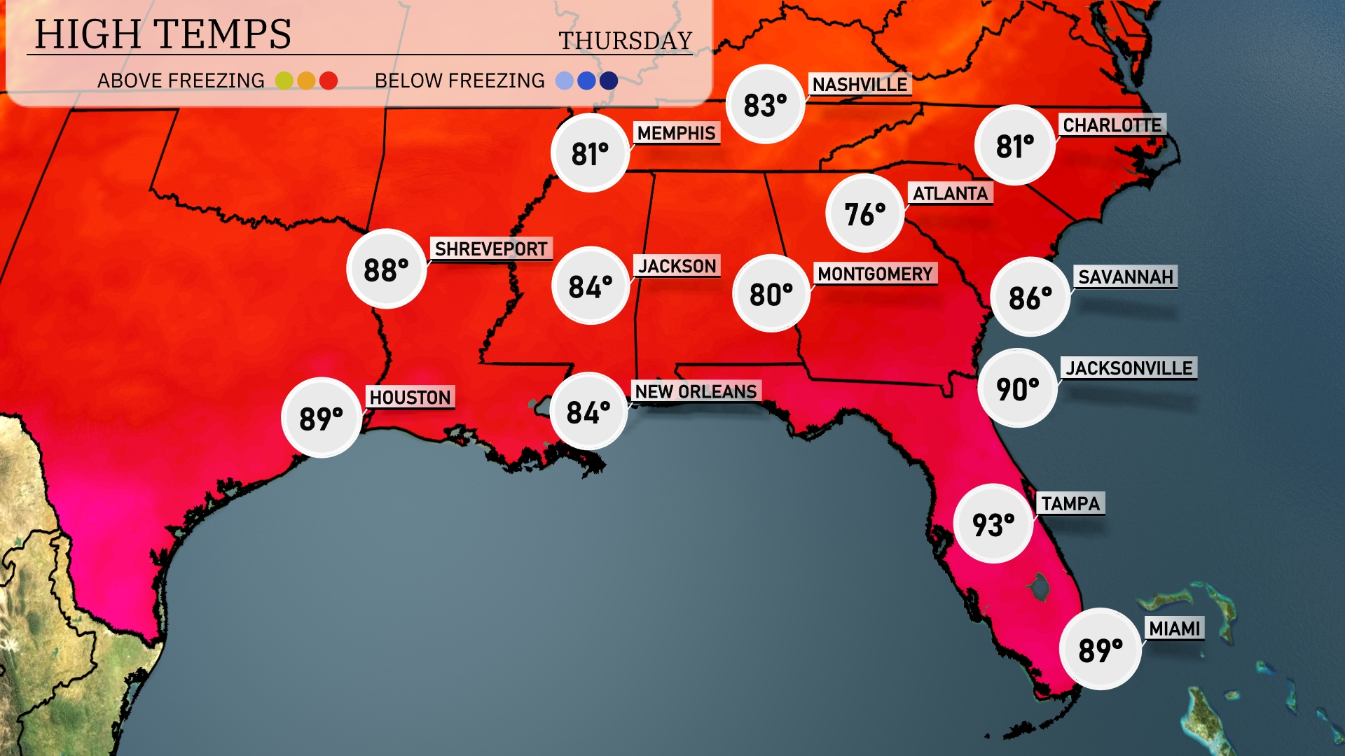
Tomorrow, the Southeast region will see high temperatures trending above average, with Miami reaching a warm 89 degrees. Jacksonville is expected to hit 90 degrees, while Tampa could soar to a sizzling 93 degrees, marking one of the hotter days this year. New Orleans and Jackson will both see comfortable highs around 84. In contrast, Atlanta will be cooler at 76 degrees, making it one of the more mild spots in the region.
A shifting weather pattern is on the horizon for the Southeast as storms move through. A cold front pushing in from the west will trigger thunderstorms from New Orleans to Tallahassee by tomorrow afternoon. These storms could bring heavy rainfall, with the potential for localized flooding, particularly during peak afternoon hours. Expect temperatures to drop slightly post-front, bringing a cooler air mass into the region.
The UV index in Miami will be very high on Wednesday with a value of 9, indicating a burn time of about 15 minutes in direct sunlight. By Thursday, the UV index jumps to an extreme level of 11, which means sunburn can occur in just 11 minutes.