Stellar Skies and Stormy Nights: The Latest Weather Trends Across the Southern Plains
By
Amy Freeze
Amy Freeze provides a comprehensive look at the weather patterns affecting the Southern Plains, from clear skies in Austin to thunderstorms moving across Texas.
Join Amy Freeze as she brings you the latest weather updates from Austin and the Southern Plains—perfect for stargazing evenings and preparing for potential storms.
Greetings from Meteorologist Amy Freeze! In tonight’s weather update for the Southern Plains, we’re looking at everything from serene skies in Austin, ideal for stargazing, to a series of potent storms across Texas. Whether you’re planning a quiet night out under the stars or need to prep for severe weather, we’ve got all the details you need. Stay tuned for our daily forecasts and expert tips to make the most of your week, regardless of the weather!
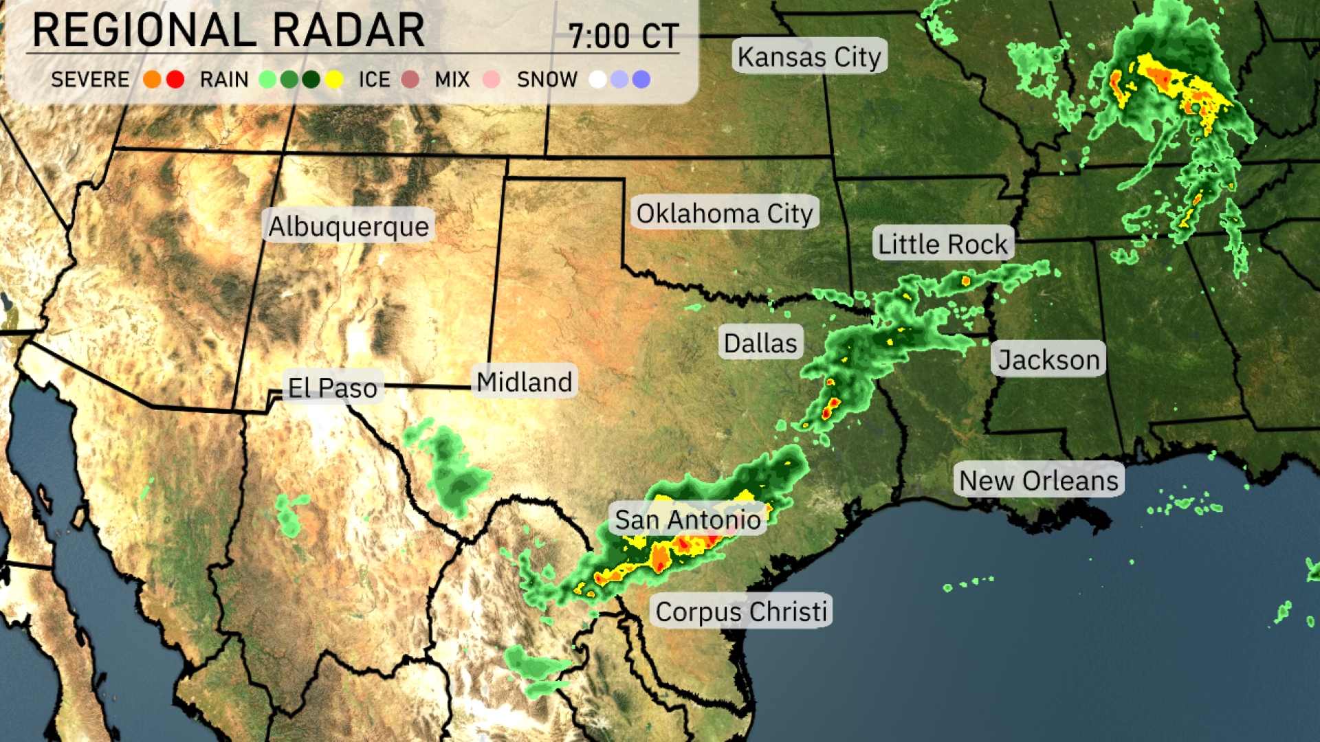
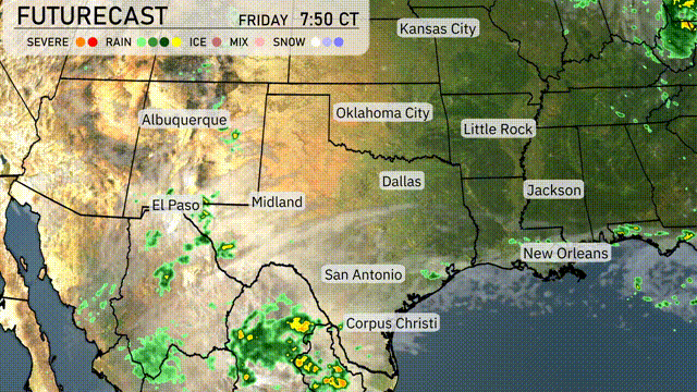
In the Southern Plains, we see an active weather day. A line of storms stretches across southern Texas, with San Antonio experiencing sharp thunderstorms moving eastward. Rain showers extend from Corpus Christi up towards Dallas, bringing moisture to the region. Little Rock and Jackson are catching the tail end of these systems as the storms push towards the Southeast. Areas like El Paso and Midland remain dry with clearer skies.
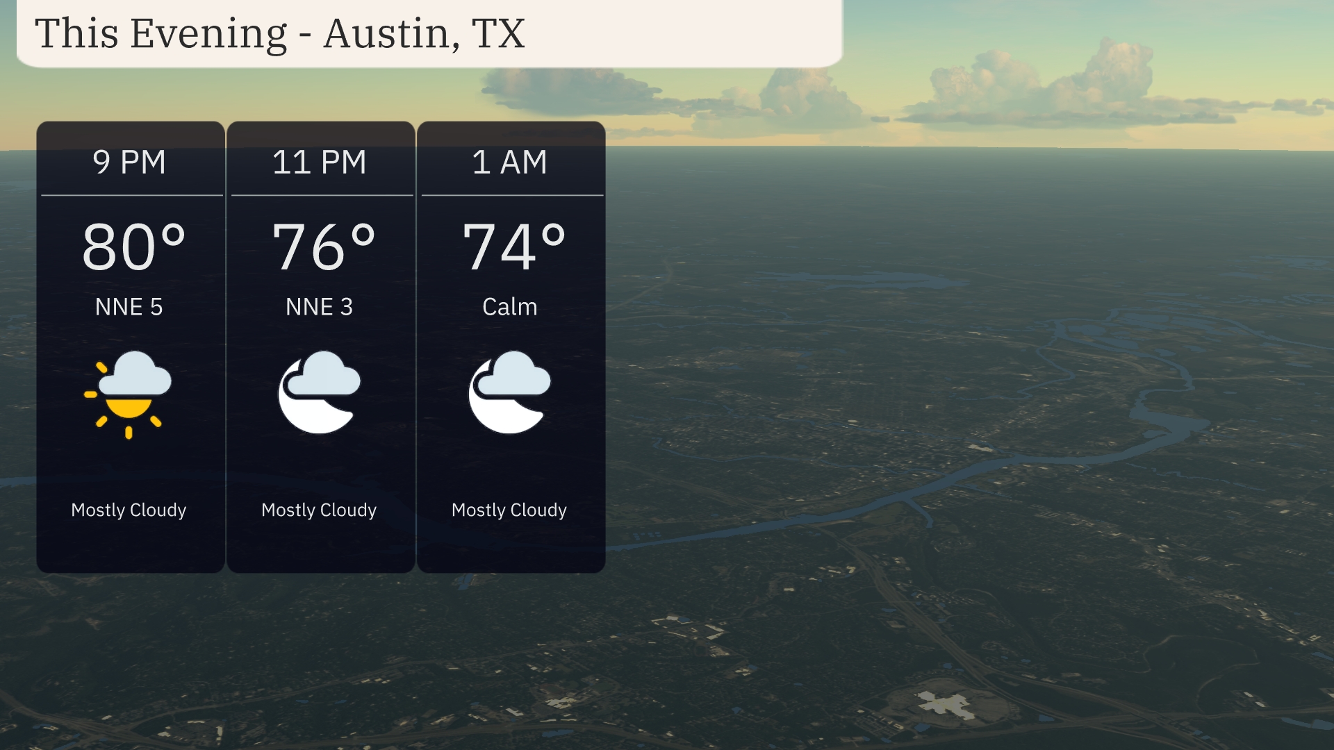
In Austin this evening, expect mostly cloudy skies. Temperatures will gradually decrease from 80 degrees at 9 PM to 74 degrees by 1 AM. Winds from the north-northeast will calm from 5 miles per hour at 9 PM to calm conditions by midnight. Keep an umbrella handy just in case the skies decide to release a few sprinkles.
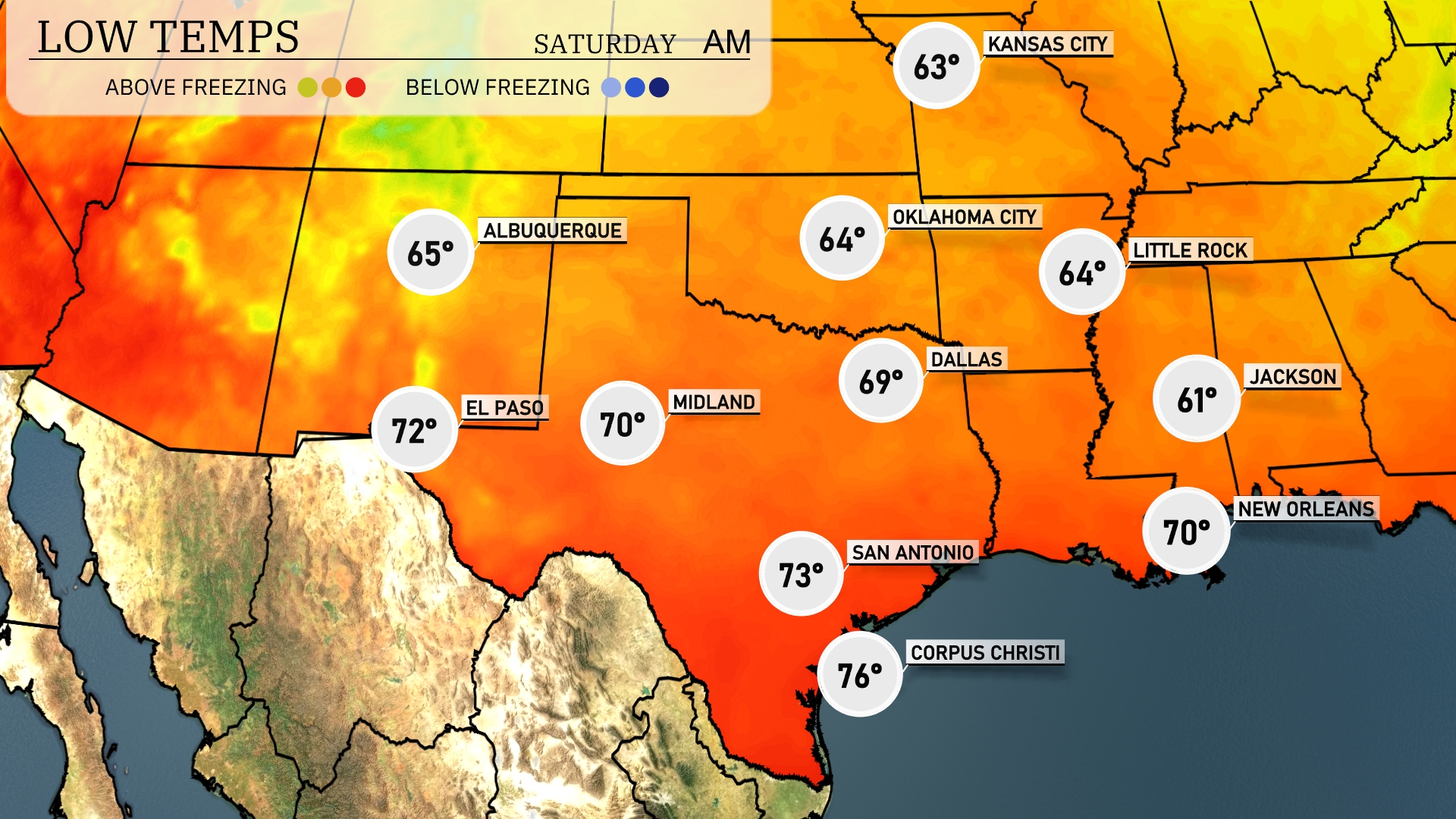
Tonight in the Southern Plains, expect a cool start with temperatures dropping significantly. Dallas will see a low of 69 degrees, while Oklahoma City cools down to 64. Little Rock is forecasted to have a low of 64 as well, closely followed by Jackson at 61. San Antonio will stay mild at 73 but remains notably cooler than previous nights. New Orleans rounds out the region with a low of 70, providing a milder contrast to northern cities.
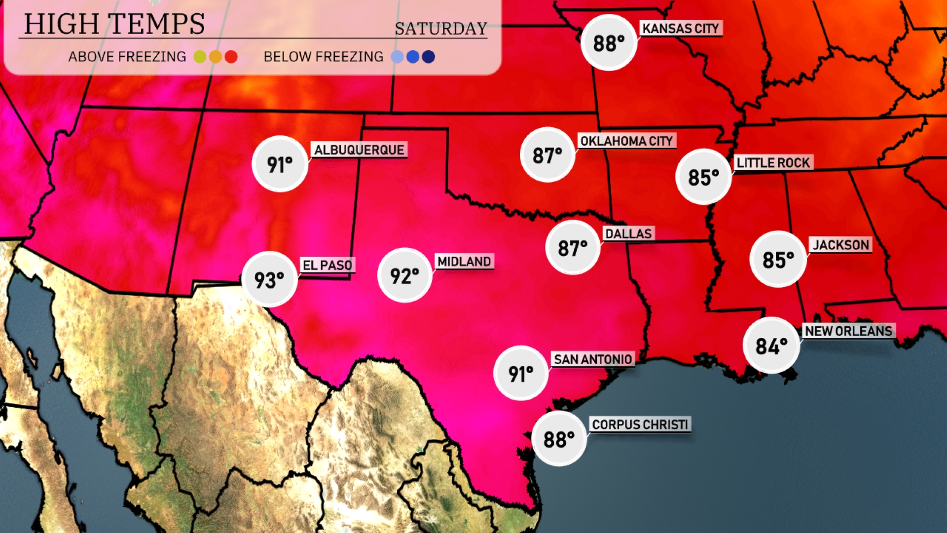
High temperatures for the Southern Plains are warming up significantly tomorrow. El Paso will reach a high of 93 degrees, while Midland is set for 92. San Antonio is expected to have a high of 91 degrees, and Corpus Christi will see a pleasant 88 degrees. Dallas is experiencing slightly cooler temperatures at 87 degrees, and Little Rock will hit 85.
A potent cold front pushes through the Southern Plains tomorrow, sparking thunderstorms from Dallas to Oklahoma City. Expect a risk of severe weather, including potential hail and gusty winds, particularly in central Texas. Rainfall brings beneficial moisture to areas like Corpus Christi, but localized flooding may be a concern. Temperatures will drop significantly behind the front, with cooler and drier air filtering in by late Wednesday. Stay weather alert as storms may impact travel and outdoor plans.
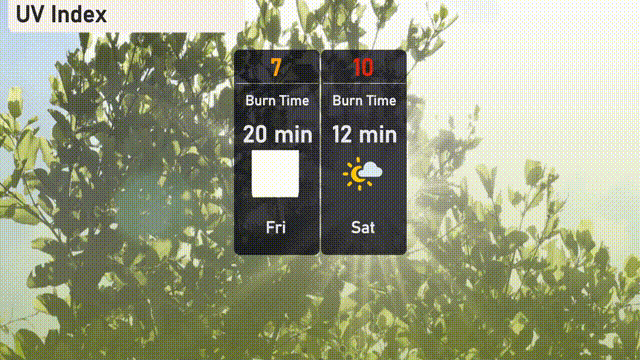
The UV index in Austin will be high at 7 on Friday, with a burn time of 20 minutes. On Saturday, the UV index climbs to a very high 10, reducing the burn time to just 12 minutes. It’s essential to use broad-spectrum sunscreen, wear a wide-brimmed hat, and seek shade to stay protected.
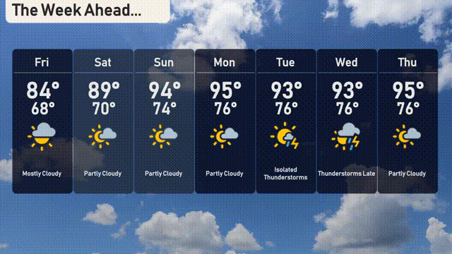
The 7-day forecast for Austin is looking warm and a bit stormy ahead.
Friday: Mostly cloudy skies with a high of 84 degrees and a low of 68.
Saturday: Partly cloudy, warming up to 89 degrees with a low of 70.
Sunday: Sunny and warmer with a high of 94 degrees, dropping to 74 at night.
Monday: Mostly sunny conditions continue with highs reaching 95 degrees and lows of 76.
Tuesday: Expect isolated thunderstorms with a high of 93 degrees and a low of 76.
Wednesday: Thunderstorms late in the day, highs again at 93 and nighttime lows of 76.
Thursday: Partly cloudy with temperatures climbing to 95 degrees and lows of 76.