From Clear Skies to Storm Alerts: Chicago and Midwest Weather Unfolded
By
Amy Freeze
Explore a comprehensive look as Amy Freeze breaks down the changing weather patterns from Chicago's clear skies to storm developments across the Midwest.
Meteorologist Amy Freeze guides you through the weather landscape with a focus on Chicago’s clear evening and significant storms affecting the Midwest. Stay updated and prepared with her expert insights.
In this detailed review, Meteorologist Amy Freeze illuminates the weather dynamics in Chicago and the broader Midwest region. From the serenity of Chicago’s clear skies to the intricate details of approaching storms, get equipped with all the necessary information to navigate through varying weather conditions. Highlights include temperature transitions, rain forecasts, and precautionary measures for upcoming weather shifts.
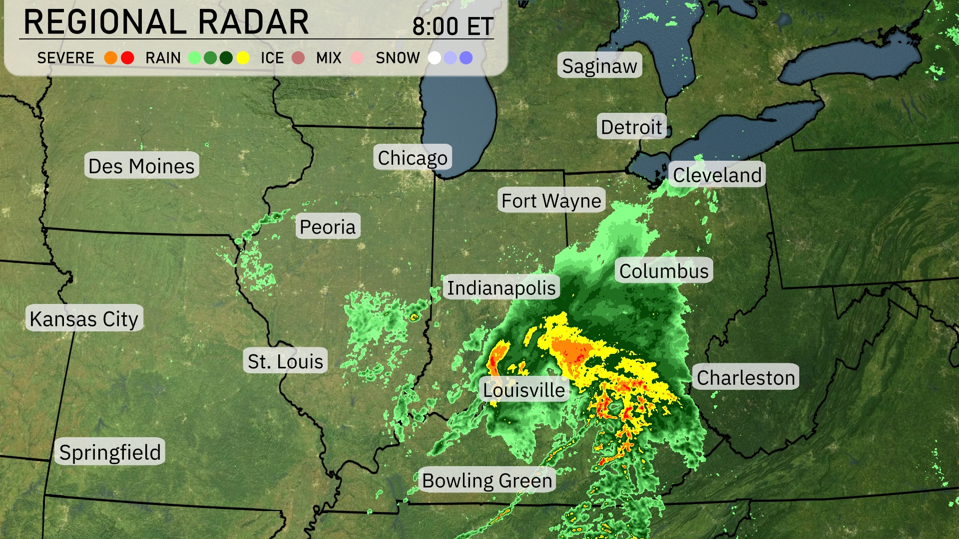
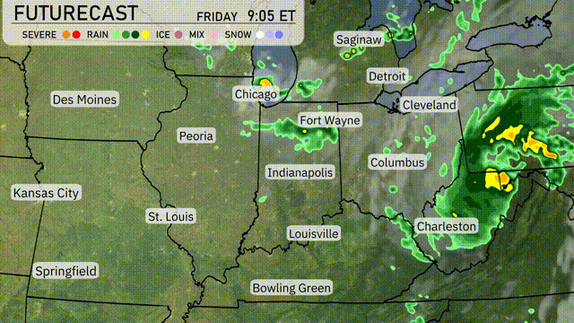
A robust line of storms is moving across the Midwest, with severe weather indicated over Louisville, pushing northeast towards Columbus. The heavy rain is centered over Indianapolis, extending into Bowling Green and approaching Fort Wayne with lighter showers. Areas like Chicago and Des Moines remain dry and clear, while Cleveland has light rain moving in. Detroit is experiencing increasing clouds as the storm system moves closer. Springfield and Kansas City enjoy calm conditions under clear skies.
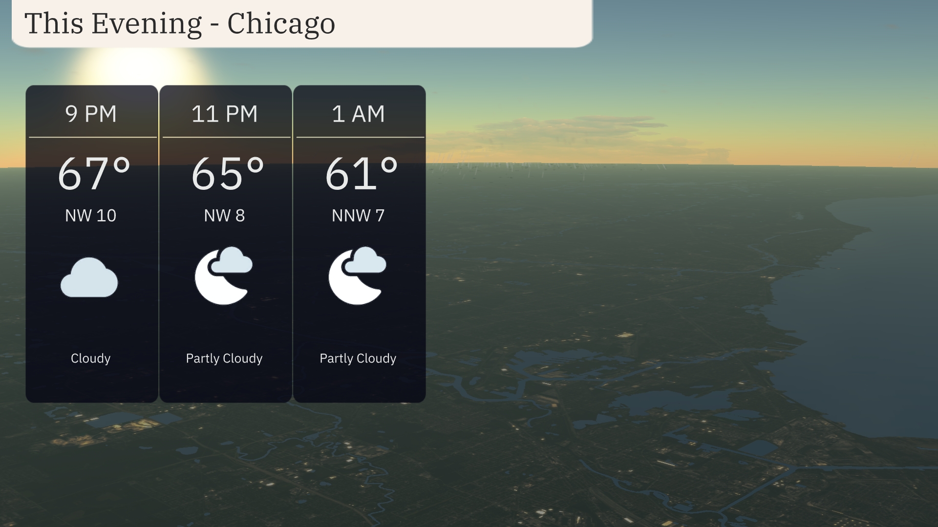
For this evening in Chicago, temperatures will transition from 67 degrees at 9 PM to 61 degrees by 1 AM. Expect a northwesterly wind ranging from 7 to 10 miles per hour. The skies will remain mostly cloudy at the start, becoming partly cloudy as the night progresses.
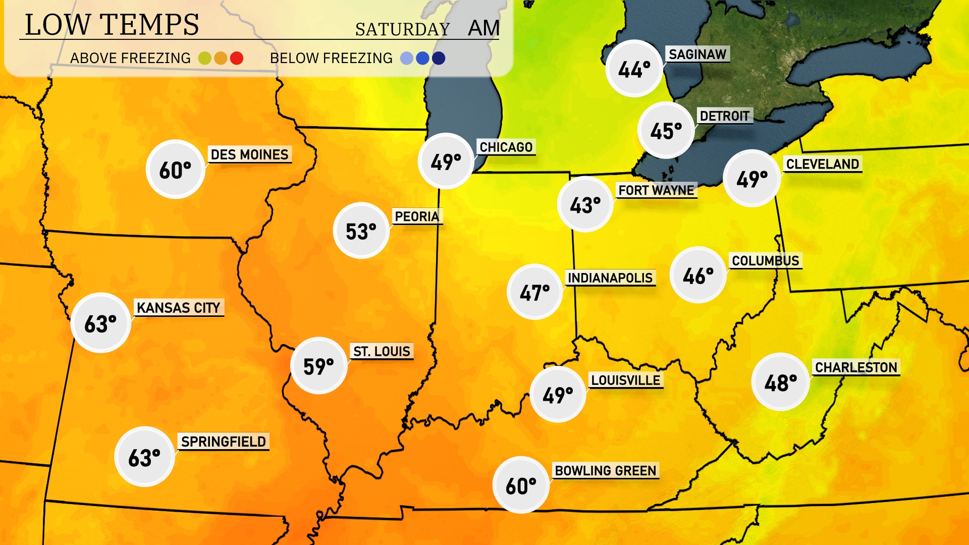
Tonight Chicago will see a low of 49 degrees, while Fort Wayne dips to 43. Indianapolis is expected to cool down to 47. Further north, Saginaw is forecasted to reach a chilly 44 degrees. Cleveland will not escape the chill either, with a low of 49 degrees.
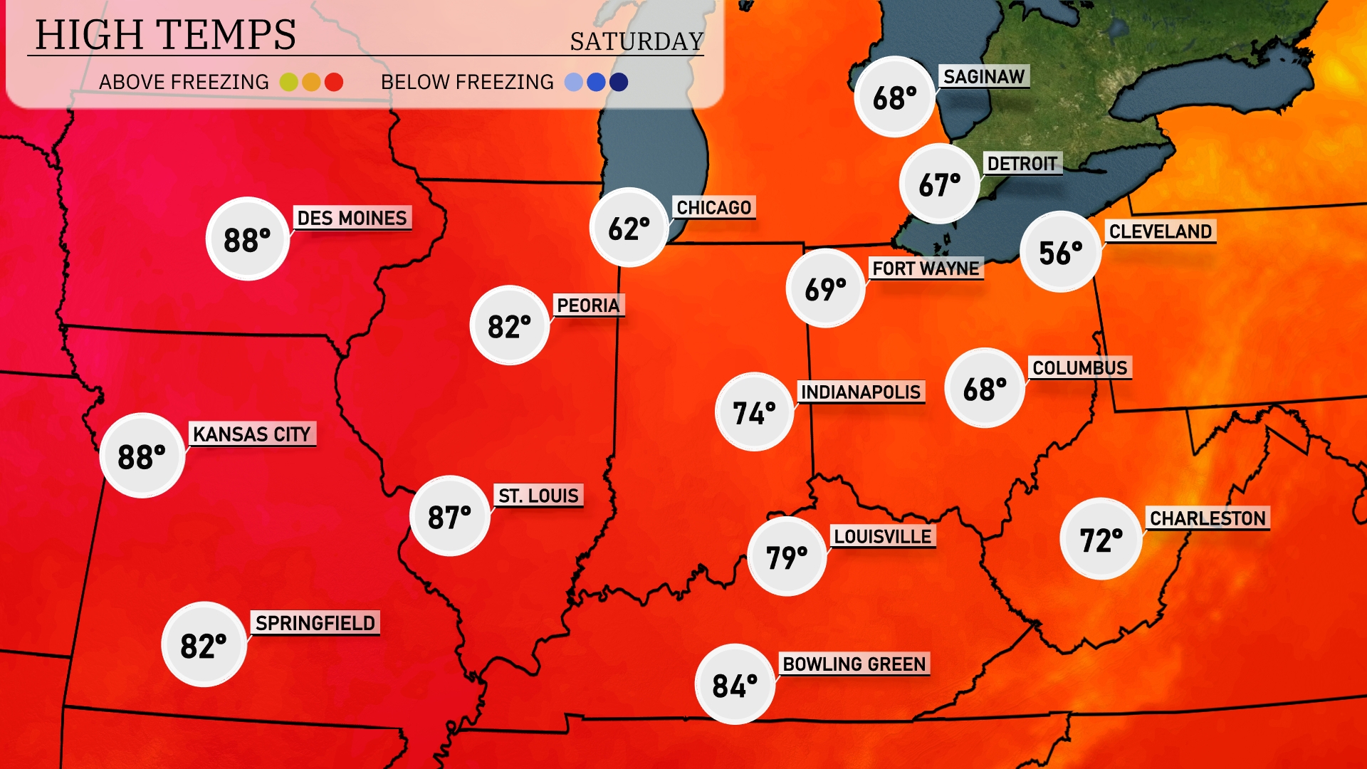
Tomorrow Kansas City and Des Moines lead the way, both reaching a hot 88 degrees. Springfield is also warm at 87, while Peoria hits a comfortable 82. Chicago will be on the cooler end with a high of 62, influenced by a nearby front. Expect temperatures to trend slightly lower in the Great Lakes region, with Cleveland only reaching 56 degrees.
A stretch of rain continues across the Midwest tomorrow, primarily impacting areas from Peoria to Indianapolis, with heavy rain developing in spots. Watch for brief localized flooding, especially in lower-lying regions. A passing frontal system may bring sporadic thunderstorms, with winds picking up slightly, particularly in the afternoon. Temperatures are expected to hover in the mid-60s, cooling down after the rain passes. By evening, drier conditions should emerge, paving the way for a calm Friday night.
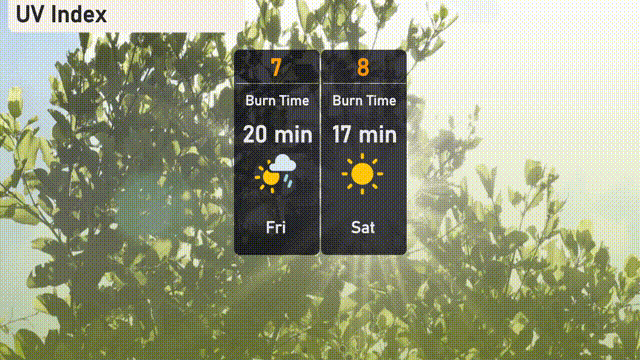
The UV index in Chicago is at a high level of 7 today, with a burn time of approximately 20 minutes during lighter rain showers. On Saturday, with an index of 8, expect sunnier conditions and quicker burn times of just 17 minutes. Be ready with sunscreen and hats if you’re stepping outside for long periods!
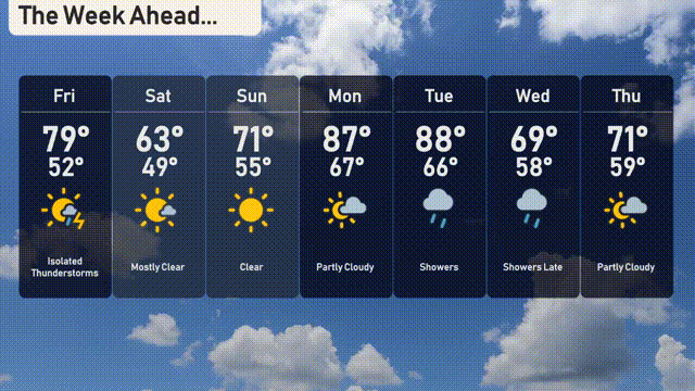
Here’s the 7-day forecast for Chicago:
Friday: Isolated thunderstorms with a high of 79 degrees and a low of 52.
Saturday: Mostly clear and cooling down to a high of 63 degrees, the low is 49.
Sunday: Bright and clear skies with a pleasant high of 71 degrees, dipping to 55 overnight.
Monday: Partly cloudy conditions expected with temperatures climbing to a warm 87 degrees and a low of 67.
Tuesday: Showers throughout the day with highs around 88 degrees and lows near 66.
Wednesday: Late showers with cooler temperatures peaking at 69 degrees and a low of 58.
Thursday: Partly cloudy skies with a high of 71 degrees and a low of 59.