Miami Weather Outlook: A Blend of Sunshine and Storms
By
Amy Freeze
Explore the diverse weather patterns affecting Miami and the Southeast, from sunny skies to imminent thunderstorms, with insights from Meteorologist Amy Freeze.
Meteorologist Amy Freeze guides you through this week’s weather in Miami, showing a mix of sun and storms. Stay updated with the latest atmospheric changes in the Southeast.
Miami Afternoon News – 05/31/2025 Meteorologist Amy Freeze here with your Southeast Forecast. Expect partly cloudy skies and isolated thunderstorms across Miami with temperatures peaking at mid-80s. A regional overview suggests varied conditions with potential thunderstorms affecting wider areas over the weekend. Dive into our detailed discussion on the impacting weather trends and learn how they might affect your week ahead. Visit our blog at https://amyfreeze.ai/ for continuous updates and more.
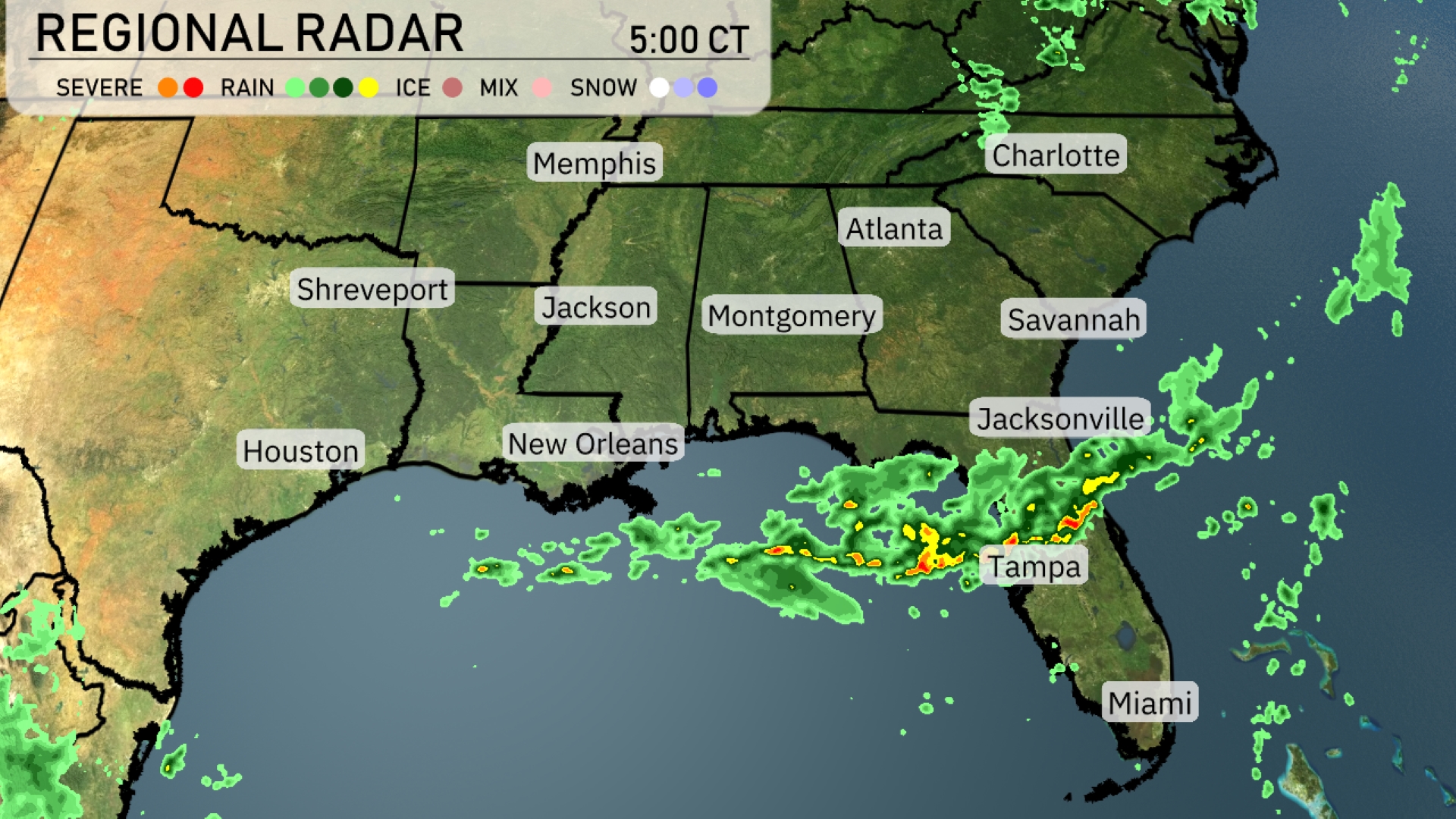
The Southeast radar shows a band of rain stretching from the Gulf of Mexico across the Florida Panhandle, with thunderstorms impacting areas near Tampa and Jacksonville. As these storms move northeast, they could bring heavy rain to parts of southern Georgia soon. The skies over Montgomery to Atlanta and northward toward the Tennessee border remain largely cloud-free. Cities like Miami are seeing a brief respite from precipitation, while areas such as Shreveport and Houston stay dry under clearer skies. Keep an eye on the developing system for potential impacts in the coastal areas farther north, such as Savannah and Charleston, as rain approaches.
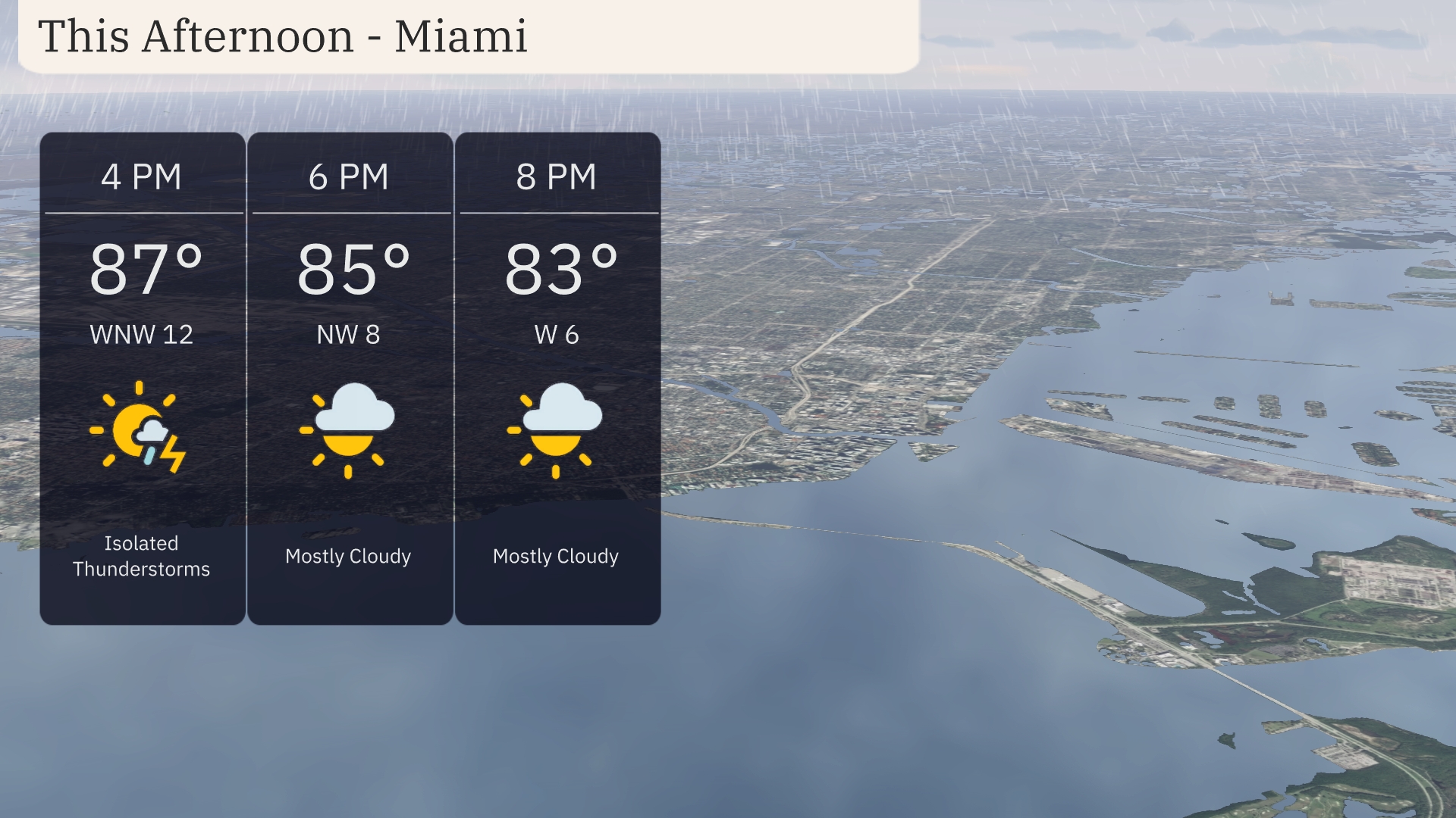
Temperatures in Miami this afternoon will hover around the mid-80s, starting at 87 degrees at 4 PM. Winds will shift from west-northwest at 12 mph to the west by 6 PM. Expect mostly cloudy skies with isolated thunderstorms earlier in the afternoon. By 8 PM, the temperature will gently decrease to 83 degrees as winds decrease to 6 mph from the west.
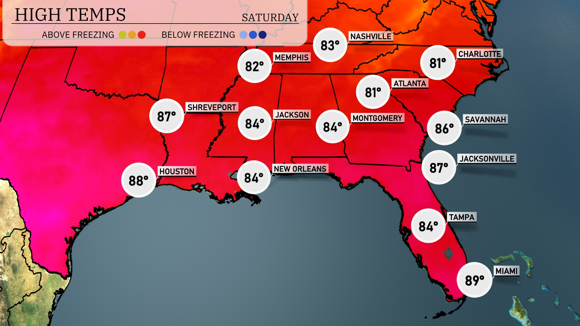
Today’s regional high temperatures are heating up across the Southeast. In New Orleans and Jackson, we can expect highs around 84 degrees. Meanwhile, Alabama cities like Montgomery will also see a pleasant 84 degrees. Over in Jacksonville, the temperature rises slightly to 87 degrees, and Savannah is close behind at 86 degrees. Down in Florida, Miami is warmest with a high of 89 degrees, while Tampa enjoys a cooler 84.
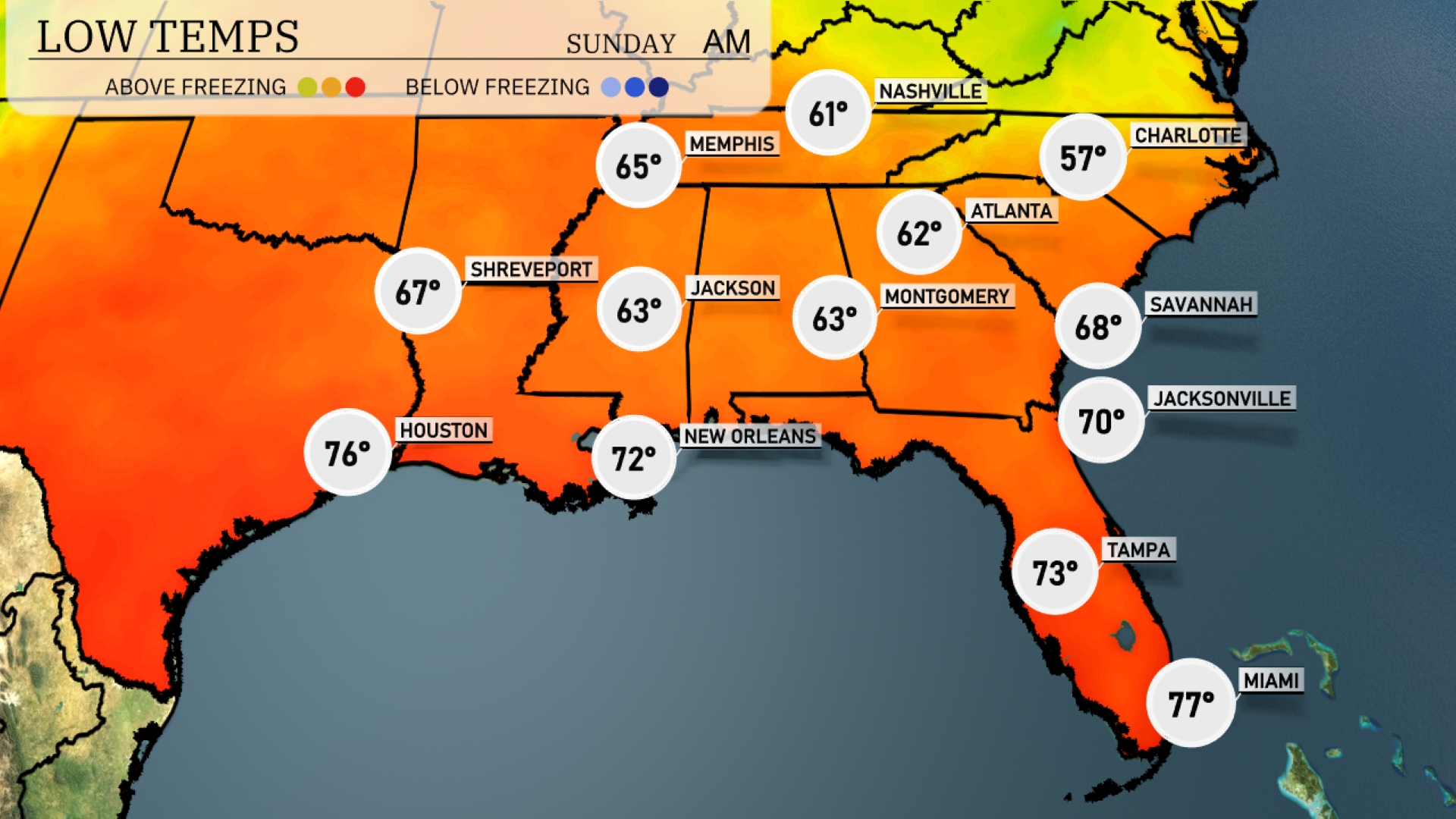
The Southeast experiences mild overnight lows with Memphis dropping to 65 degrees. Expect 63 in Jackson and Shreveport. Nashville will see a low of 61, while Atlanta is forecasted to be at 62. Charlotte will be the coolest major city in the region tonight with a low of 57. In contrast, Miami remains warm at 77 degrees, shielding the city from the chill.
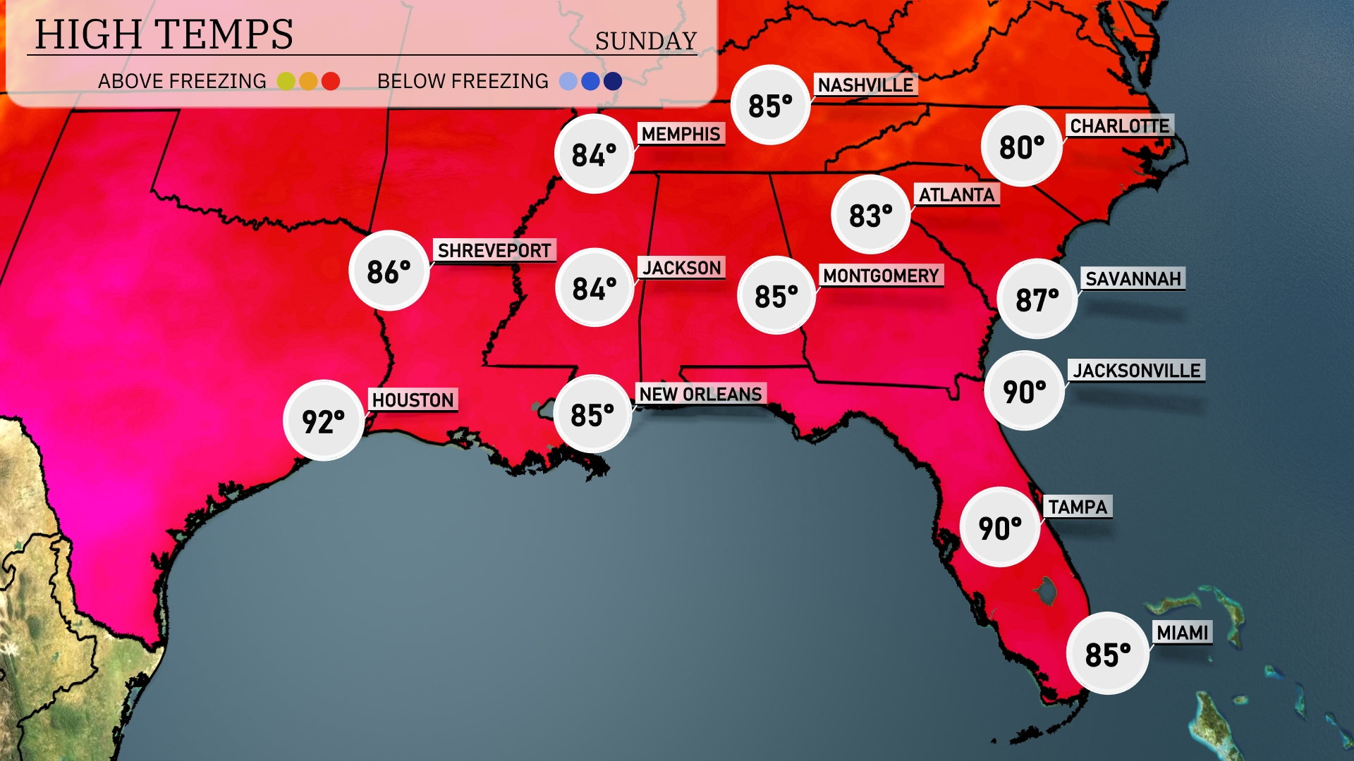
Tomorrow Houston is set to hit a steamy 92 degrees, while New Orleans and Montgomery will both reach 85. Atlanta will see a high of 83 degrees, and Savannah is expected to warm up to 87. Jacksonville and Tampa are both forecasted to touch 90 degrees, making for a hot day across the region.
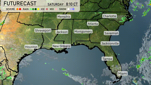
Showers and storms will continue to develop in the Southeastern region on Saturday. By morning, expect rain from Jackson to Atlanta, with potential thunderstorms for Montgomery and New Orleans. As the day progresses, Charlotte and Savannah could experience scattered showers. The wet pattern continues into the evening, with a chance of severe thunderstorms across parts of Georgia and Alabama.
The UV index in Miami will be high on Saturday with a value of 7, indicating a burn time of about 20 minutes under the sun. On Sunday, the index decreases to a moderate level of 5, with a burn time of approximately 27 minutes.