Calm Skies and Upcoming Storms: Your Comprehensive Midwest Weather Guide
By
Amy Freeze
Dive into our detailed forecast for Chicago and beyond with Amy Freeze, covering everything from this evening's cool temperatures to the thunderstorms brewing on the horizon.
Catch up on the latest weather trends in Chicago and the Midwest with Amy Freeze’s insightful updates. From evening chills to daytime warmth, we cover it all.
Meteorologist Amy Freeze provides an in-depth look at the weather patterns affecting Chicago and the Midwest. Insightful updates on temperature variations, clear skies, and the potential for severe weather are all covered in our extensive report. Keep this page bookmarked for daily updates and prepare for any weather condition with confidence.
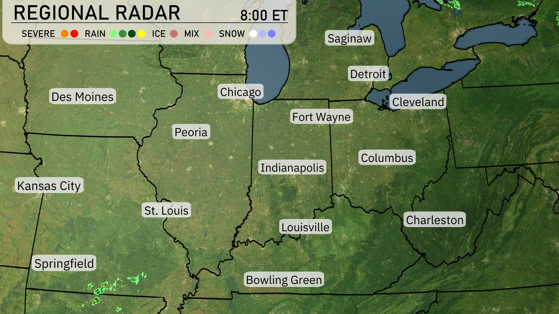
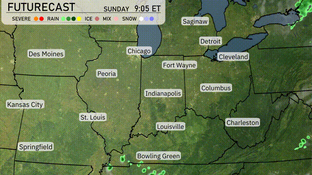
The Midwest regional radar is showing clear conditions across much of the area. However, rain showers are beginning to make an appearance near Springfield, likely heading towards the St. Louis area. Elsewhere, skies remain clear in cities such as Des Moines, Chicago, and Indianapolis, providing a break from precipitation. Scattered clouds are visible moving across the eastern stretches, covering areas like Charleston. No severe weather is currently impacting the region, making it a relatively calm morning for the Great Lakes and surrounding states.
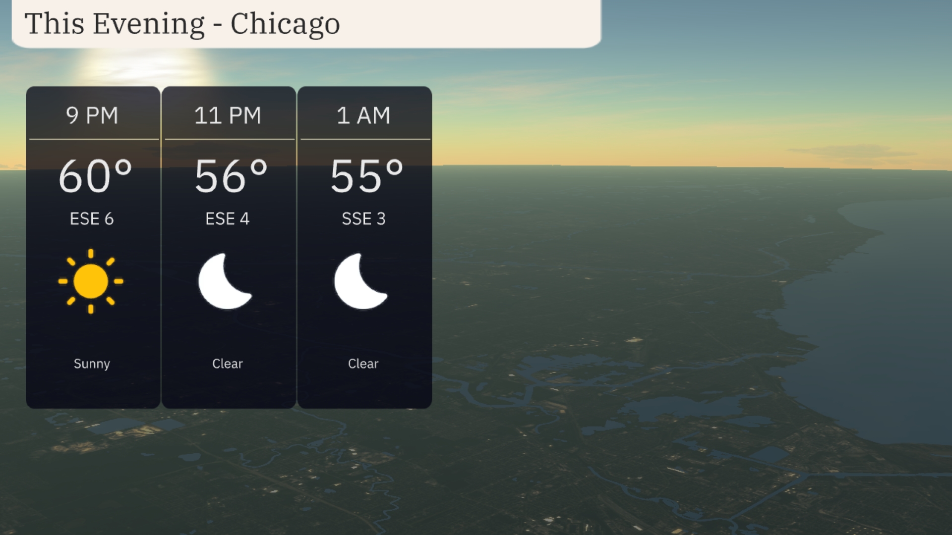
This evening in Chicago, temperatures start at 60 degrees at 9 PM, gradually cooling to 56 degrees by 11 PM, and 55 degrees at 1 AM. The skies will remain clear throughout the evening, ensuring unobstructed views for any outdoor plans. A gentle east-southeast breeze will hover around 6 mph, calming to 3 mph as the night progresses.
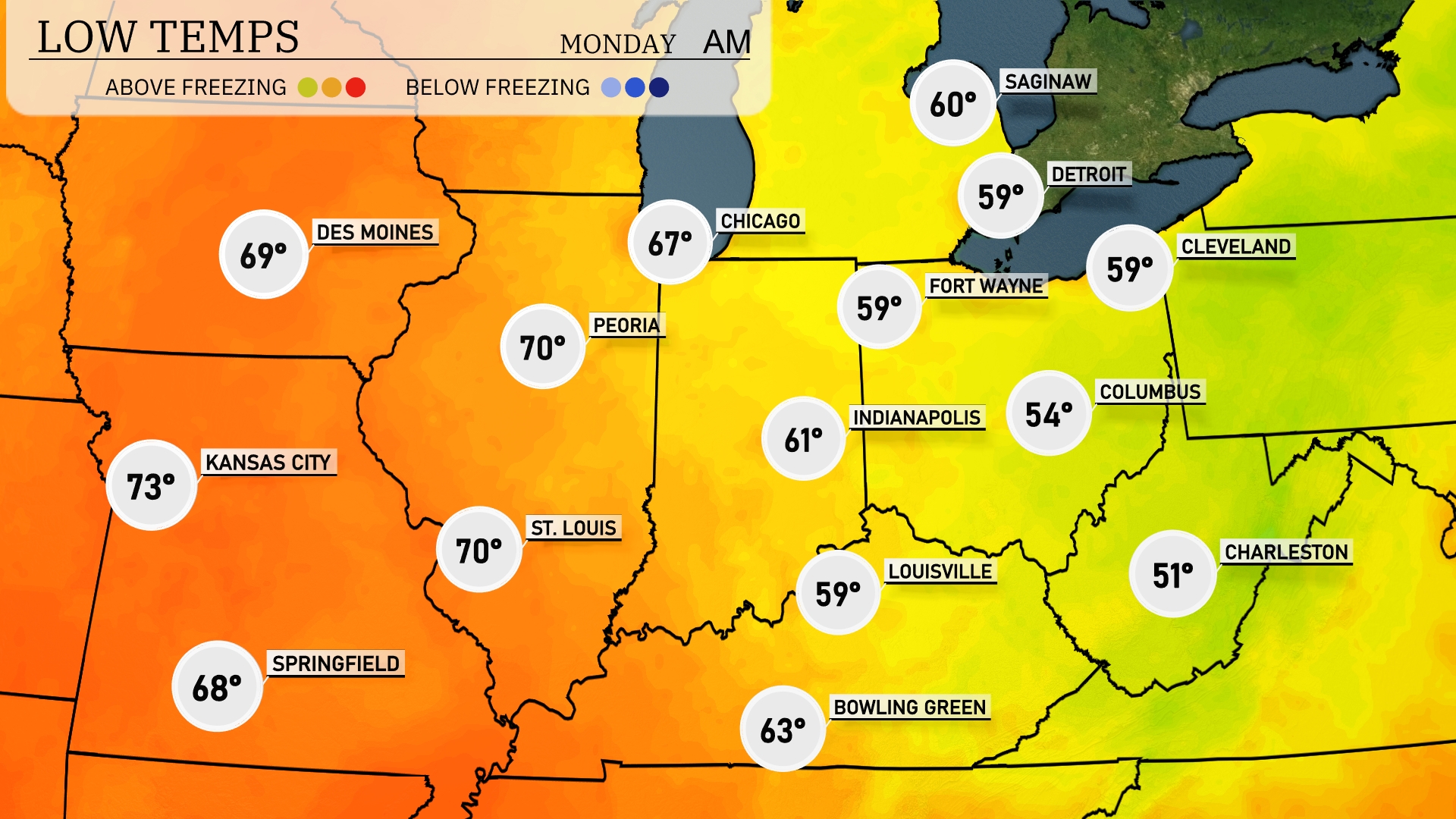
Tonight Chicago will dip to a low of 59 degrees, while Indianapolis is expected at 54. Farther south, Columbus will see a chillier 51 degrees, and Louisville will be around 59. Fort Wayne will drop to 57 degrees, which is cooler than recent nights.
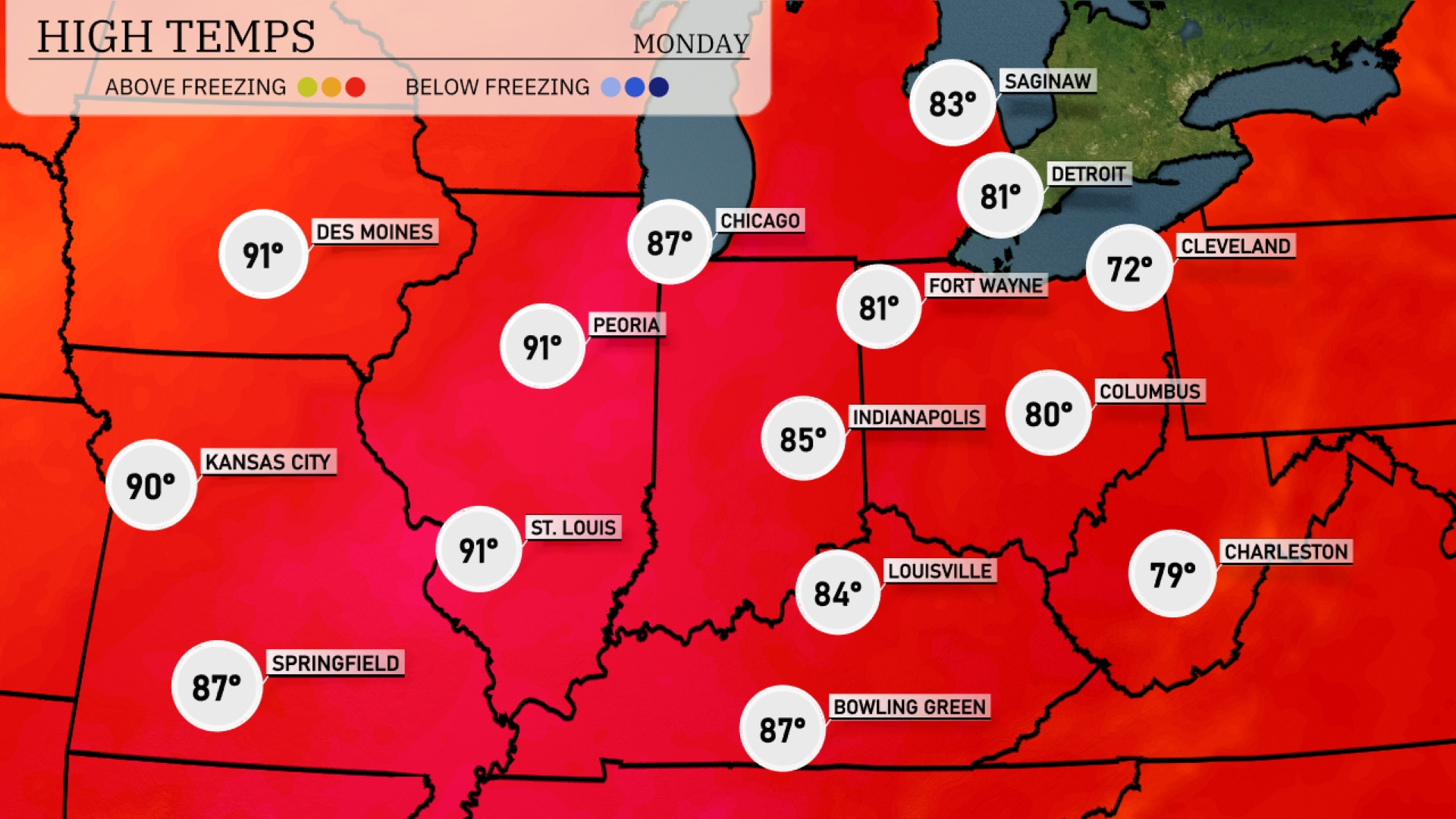
Tomorrow Des Moines and Peoria lead the way with expected highs of 91 degrees, while Kansas City and St. Louis also warm up to 90 degrees. Indianapolis will see a high of 85 degrees, with Louisville reaching 84. Chicago isn’t far behind at 87 degrees, and Fort Wayne sits at a comfortable 81.
A cold front moves through the Midwest, bringing scattered thunderstorms and potential for isolated severe weather, especially in areas like Chicago and Fort Wayne. Expect locally heavy rain, possibly causing travel disruptions, especially during the afternoon. As the system moves east, anticipate cooling temperatures behind the front, with highs dropping to the low 70s by the end of the day. The strong winds accompanying this front may also lead to hazardous conditions, so stay weather alert. By late tomorrow, conditions should start to stabilize, bringing clearer skies into the weekend.
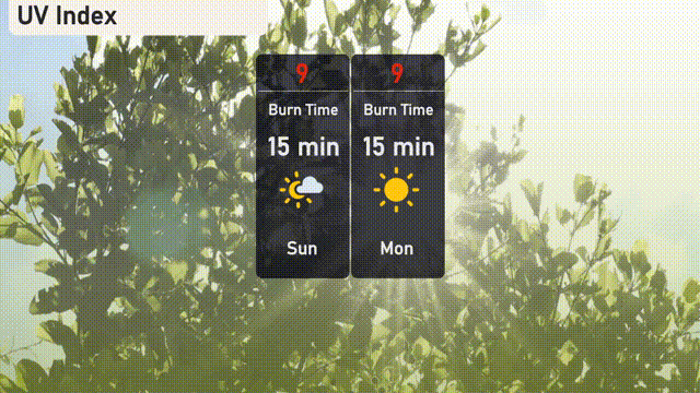
The UV index in Chicago is expected to reach a high level of 9 both today and tomorrow. This means a quick burn time of just 15 minutes in direct sunlight.
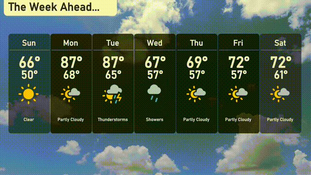
For the 7 day forecast in Chicago:
Sunday: Clear skies with a high of 66 degrees and a low of 50 degrees.
Monday: Partly cloudy, warming up to 87 degrees during the day, cooling to 68 at night.
Tuesday: Thunderstorms are expected with temperatures reaching a high of 87 degrees and a low of 65 degrees.
Wednesday: Showers with a high of 67 degrees, dipping down to 57 degrees overnight.
Thursday: Partly cloudy and slightly warmer, peaking at 69 degrees and going down to 57 degrees.
Friday: Another partly cloudy day, with a high of 72 degrees and a nighttime low of 57 degrees.
Saturday: Enjoy partly cloudy skies with a high of 72 degrees and a low of 61 degrees.