Starry Nights and Sunlit Days: This Week in Southwest Weather
By
Amy Freeze
Meteorologist Amy Freeze provides an in-depth look at the tranquil skies over Salt Lake City and beyond, with detailed forecasts for the entire Southwest region.
Clear skies and perfect temperatures define this week’s weather in Salt Lake City and across the Southwest. Dive into our full forecast for all details from coast to plains!
Experience starry nights and sunlit days across the Southwest, as Meteorologist Amy Freeze delves into the serene weather conditions over Salt Lake City and expansive forecasts covering cities from Phoenix to San Francisco. Learn about varying temperatures, upcoming thunderstorms, and sun safety tips for high UV days.
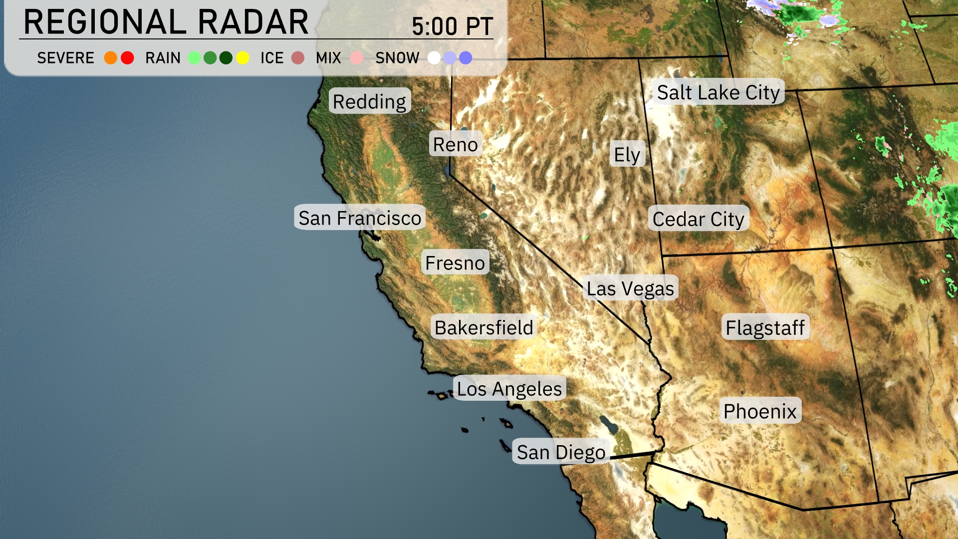
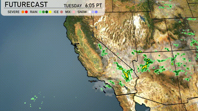
The radar reveals a serene scene across much of the Southwest with no significant precipitation. Showers are visible north of Salt Lake City moving eastward. Ely has clouds are areas like Phoenix and Las Vegas are basking in clear skies. Along the California coast, conditions appear dry, with San Francisco, Los Angeles, and San Diego enjoying clear weather. Bakersfield and Fresno also remain under clear skies, indicating a calm weather pattern without any immediate disturbances.
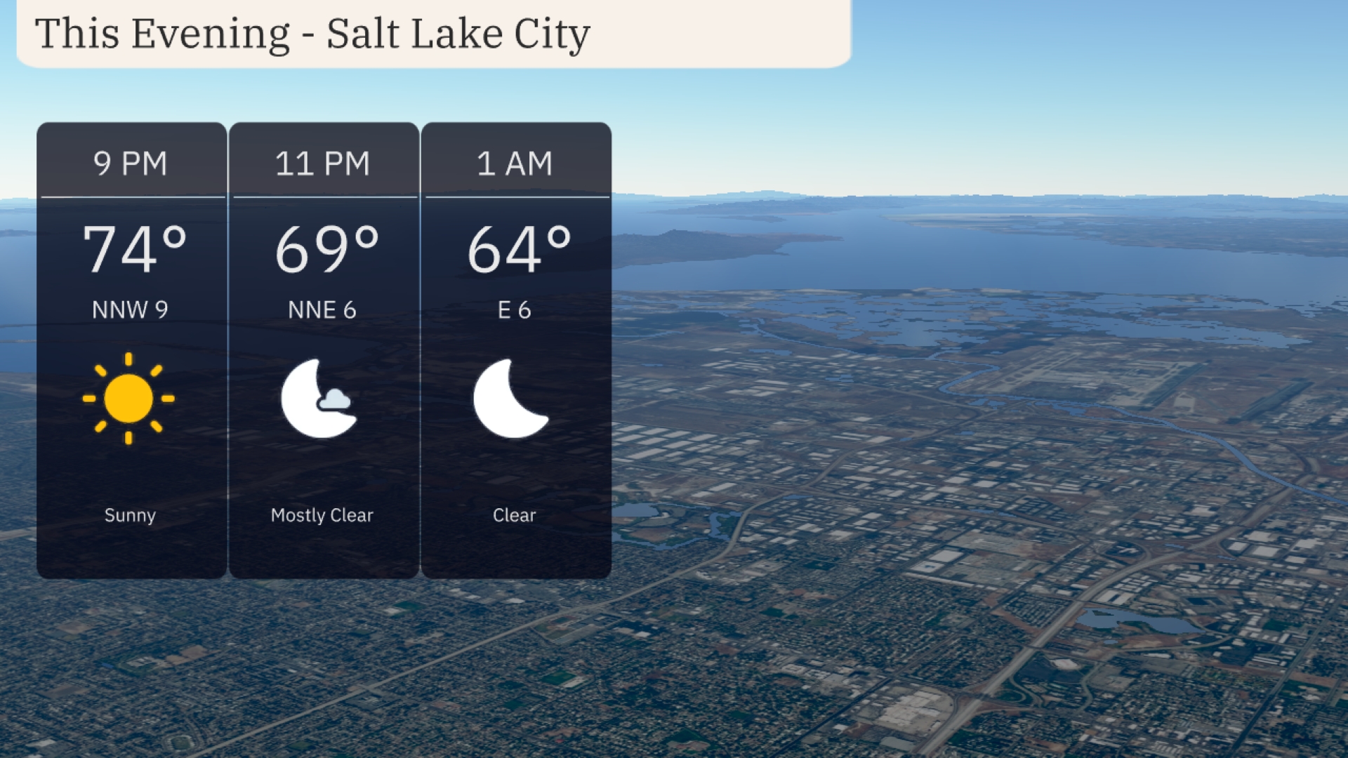
For this evening in Salt Lake City, temperatures will gradually decrease, starting at 74 degrees by 9 PM with a gentle northwest wind at 9 miles per hour. By 11 PM, the temperature will dip to 69 degrees with mostly clear skies and a north-northeast wind at 6 miles per hour. At 1 AM, clear conditions continue, as the temperature falls to 64 degrees with an easterly breeze at 6 miles per hour.
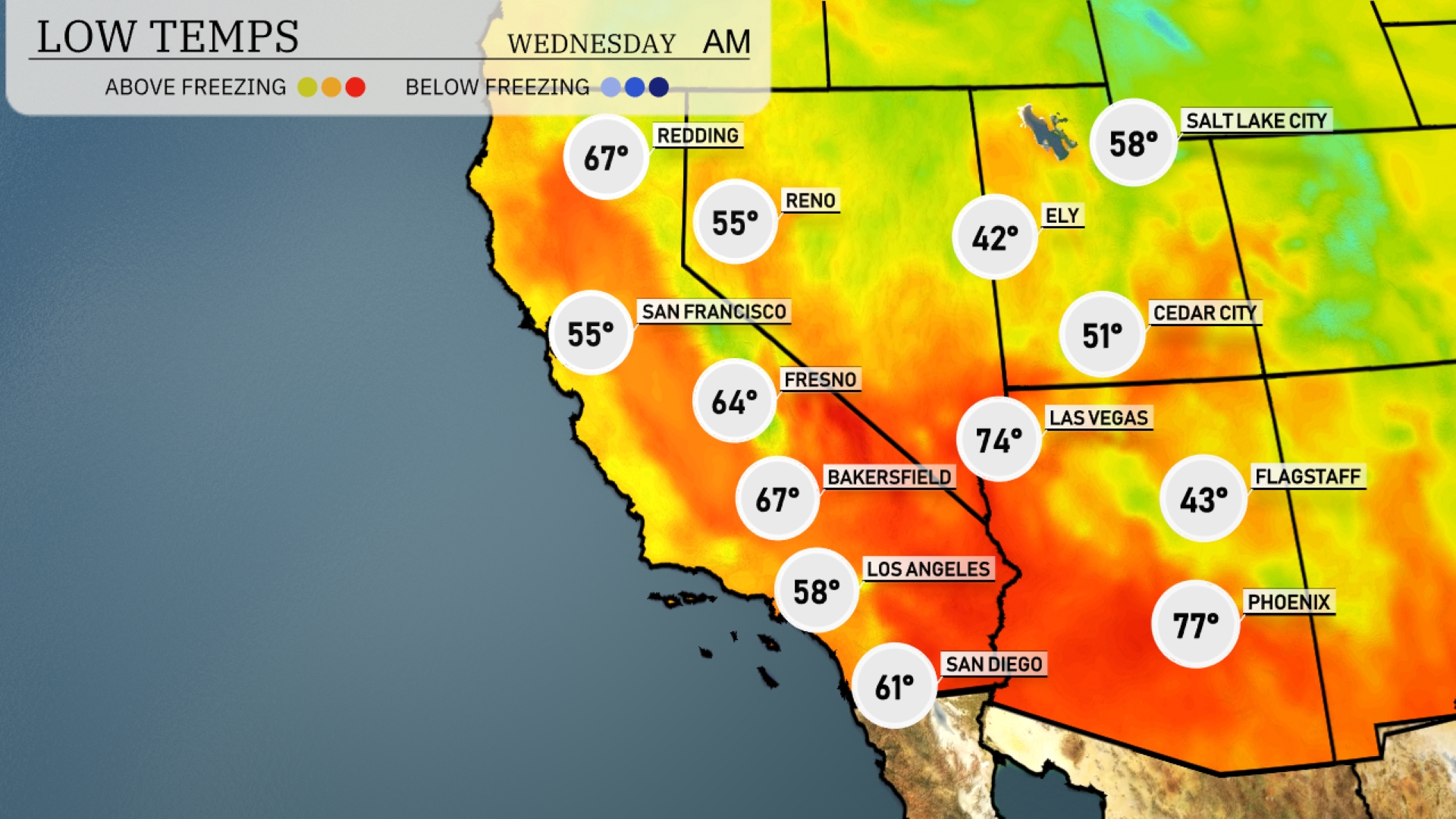
Tonight Las Vegas will cool down to a brisk 74 degrees. Flagstaff is expected to drop to 43, while Ely will see chilly conditions at 42 degrees. Phoenix remains warmer at 77. Expect San Diego to settle at 61, providing a milder option in comparison.
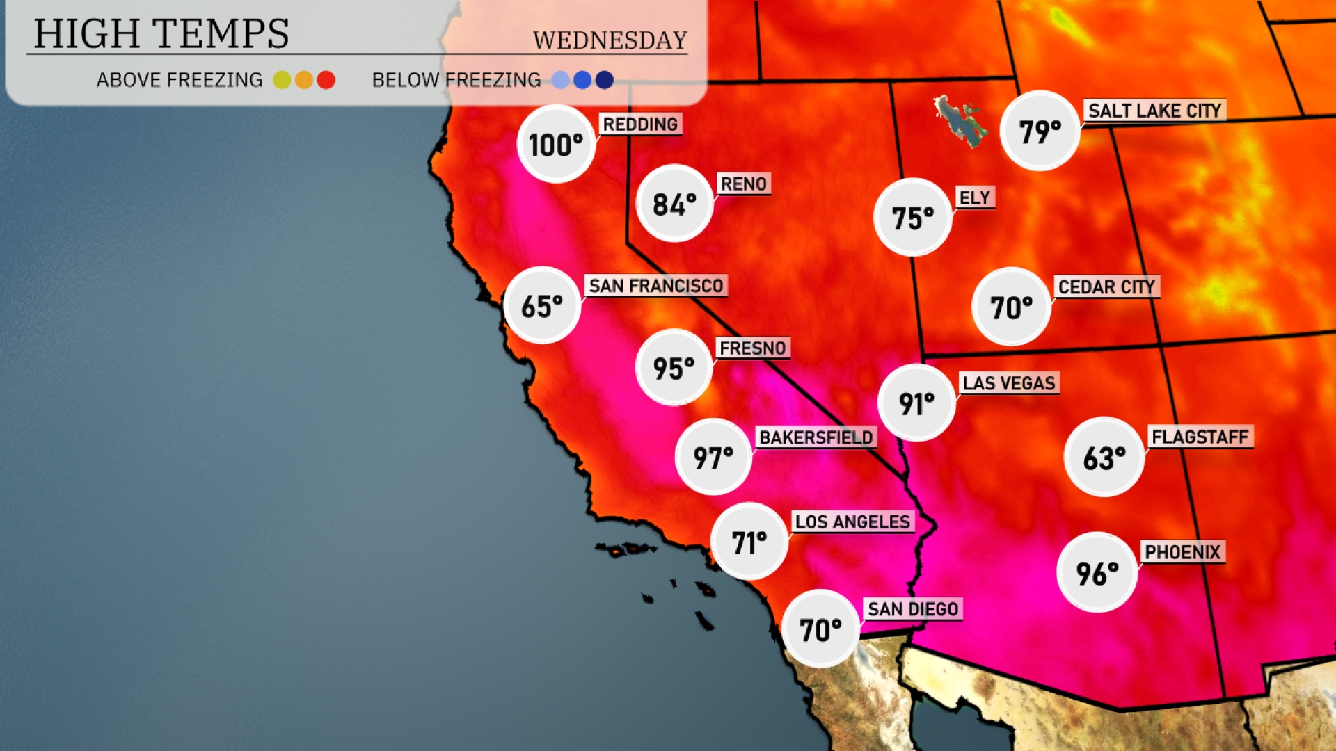
High temperatures in the Southwest are trending above average for tomorrow. Phoenix is expected to soar to 96 degrees, while Las Vegas will reach a warm 91 degrees. In California, Bakersfield recovers nicely with highs around 97 degrees and Fresno will see a high of 95 degrees. Coastal areas like San Diego will also enjoy pleasant weather, reaching 70 degrees.
Tomorrow’s outlook for the Southwest shows scattered thunderstorms, primarily affecting southeastern California and western Arizona with pockets of intense rain. Expect an active weather pattern beginning mid-afternoon, potentially resulting in localized flooding due to quick heavy downpours. Temperatures will trend slightly cooler than average, especially in areas experiencing heavier rain, but should normalize once storms pass. No severe weather risks identified, but continue monitoring for updates. High pressure systems will start to rebuild by late Wednesday, bringing clearing skies and more stable weather conditions.
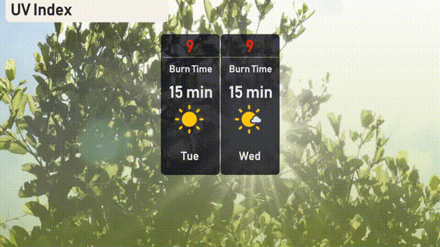
Watch out for very high UV exposure in Salt Lake City with an index of 9 on both Tuesday and Wednesday! Sun safety measures are a must, as skin can burn in as little as 15 minutes.
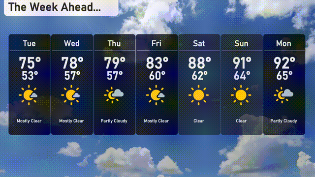
For the 7-day outlook in Salt Lake City:
Tuesday: Prepare for mostly sunny skies with a comfortable high of 75 degrees and a low of 53 degrees.
Wednesday: Enjoy another mostly clear day as temperatures warm up slightly to a high of 78 degrees with a low around 57 degrees.
Thursday: It’s a partly cloudy day with the high reaching 79 degrees and cooling to 57 degrees at night.
Friday: Expect mostly clear skies with temperatures climbing to a high of 83 degrees and a low near 60 degrees.
Saturday: A lovely clear day, with the mercury rising to 88 degrees and nighttime temperatures around 62 degrees.
Sunday: Enjoy clear skies and plenty of sunshine, with a high of 91 degrees and a low of 64 degrees.
Monday: Heading into the new week with partly cloudy conditions and a warm high of 92 degrees, cooling to 65 degrees overnight.