Storms to Clear Skies: Tracking Chicago’s Weather Shifts
By
Amy Freeze
Join Meteorologist Amy Freeze as she navigates through the turbulent weather changes affecting Chicago this week, from thunderstorms to pleasantly sunny days.
Meteorologist Amy Freeze details the shift from severe weather to clearer, milder conditions in Chicago, covering forecasts, temperature trends, and safety tips.
Chicago Evening News – 06/04/2025 Meteorologist Amy Freeze here with your Midwest Forecast update. This evening in Chicago, expect partly cloudy skies with a gentle breeze and occasional showers. The Midwest is under a sweeping line of storms, affecting day-to-day life with fluctuations in temperatures and conditions. Looking ahead, clearer skies are forecasted into the weekend, providing perfect conditions for outdoor activities. Don’t forget to check out our detailed safety tips and more at https://amyfreeze.ai/
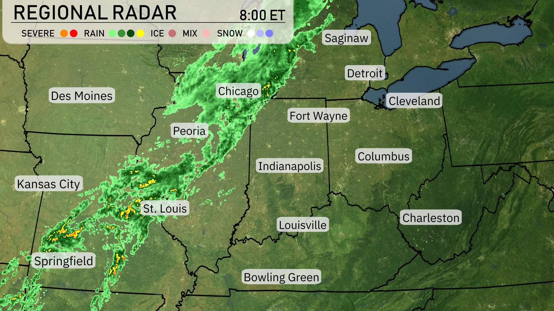
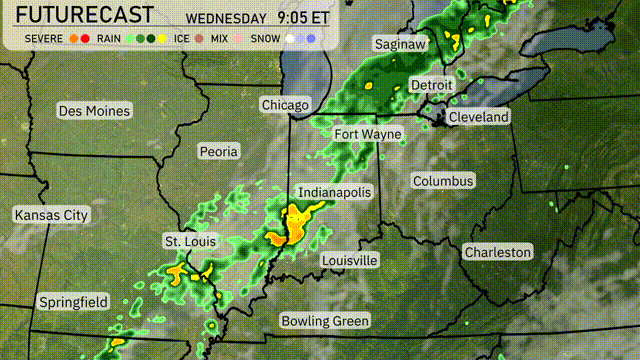
A line of storms is sweeping across the Midwest, stretching from Kansas City up to Chicago. Severe weather conditions are currently affecting areas near St. Louis, moving northeast. Rain is tracking across central Illinois, approaching Indianapolis. Chicago is experiencing ongoing precipitation, with showers extending toward Fort Wayne and Detroit. Des Moines and Cleveland are enjoying clearer skies for now.
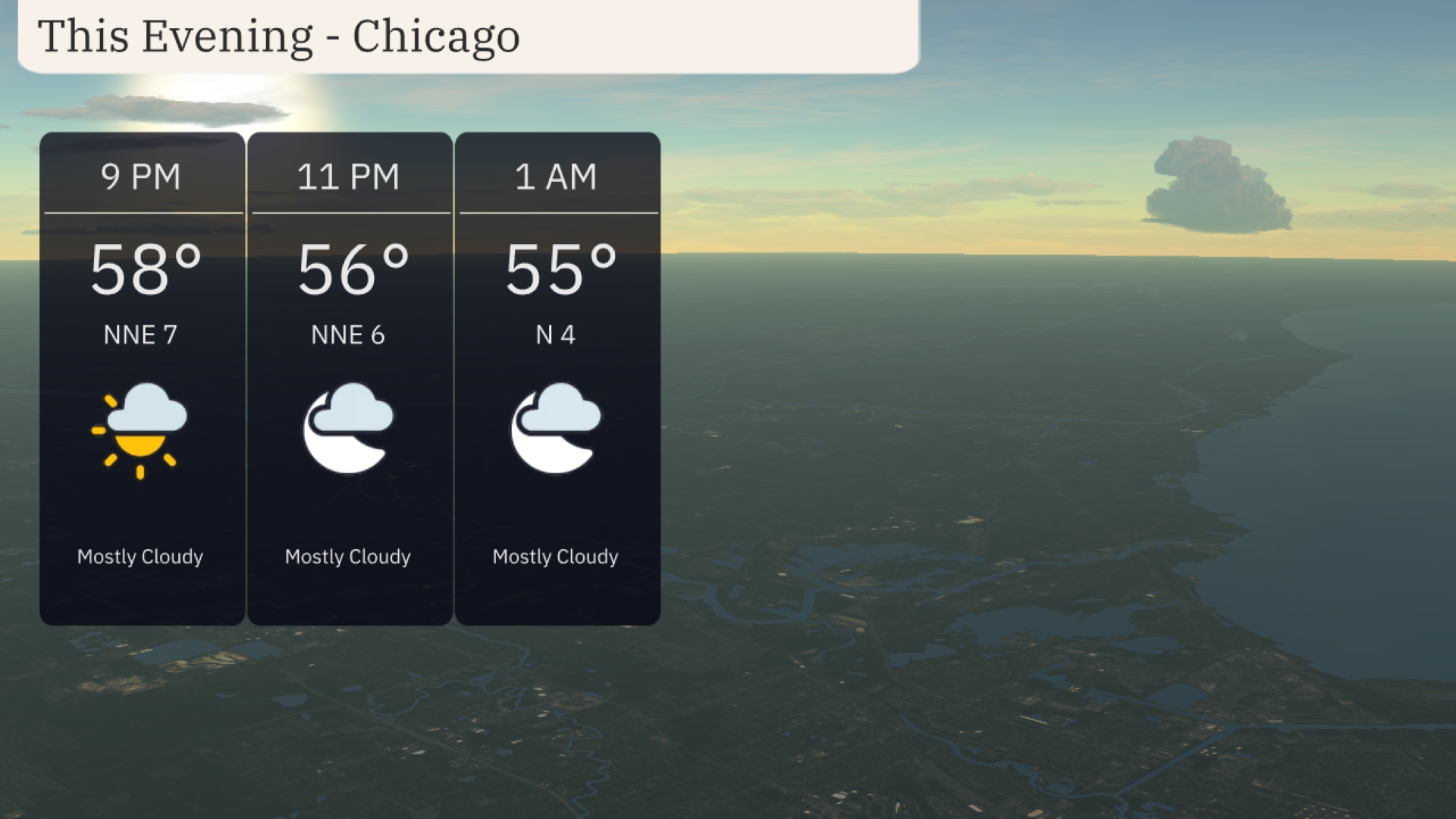
Temperatures in Chicago this evening will start at 58 degrees at 9 PM, cooling slightly to 56 degrees by 11 PM, and 55 degrees by 1 AM. Expect mostly cloudy skies throughout the evening, offering limited chances for clear views of the stars. Winds will be gentle, coming from the north-northeast at 7 mph initially, decreasing to 4 mph overnight.
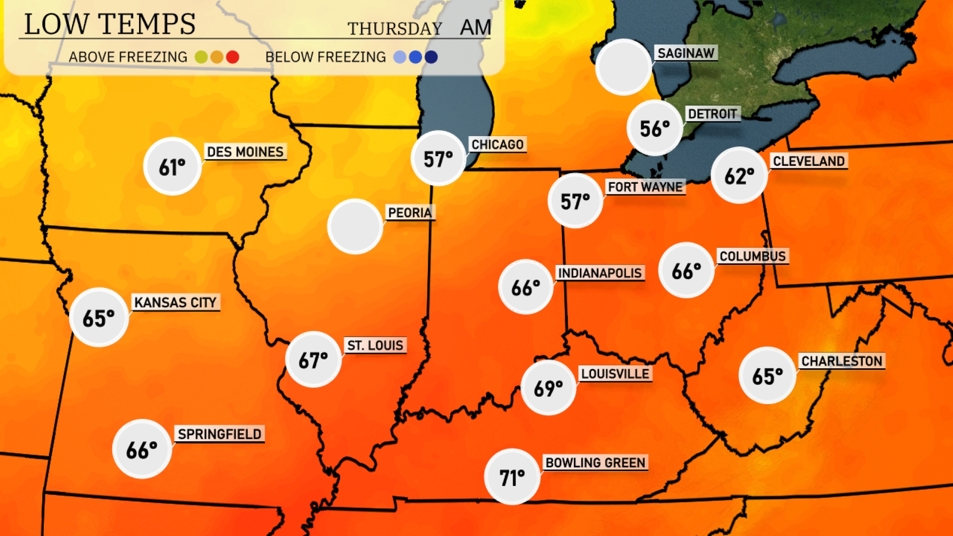
Tonight Chicago will drop to 57 degrees, while Des Moines cools to 61. Indianapolis is expected to see a low of 66, with St. Louis at 67 degrees. Fort Wayne will feel a chill at 57 degrees, and Cleveland experiences a milder night at 62.
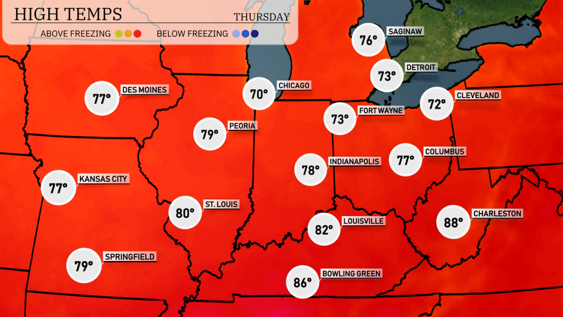
Tomorrow St. Louis reaches a high of 80 degrees. Kansas City and Springfield will both enjoy highs around 77 and 79 degrees, respectively. Chicago is slightly cooler at 70 degrees, while Indianapolis warms up to 78. Bowling Green is expected to hit a high of 86 degrees, which is above average for this time of year.
A line of storms will move through the Midwest on Wednesday, with heavy rain stretching from eastern Missouri, through Illinois, reaching Indiana and Michigan by tonight. Expect thunderstorms with high winds particularly around Indianapolis and Fort Wayne, where conditions might intensify. Rainfall could create slippery conditions on roadways, urging caution for travel. The cold front brings cooler temperatures on Thursday, setting the stage for clearer skies into the weekend.
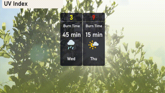
The UV index in Chicago is low today, with a value of 3, as storm systems provide a natural block against UV rays. On Thursday, expect a high UV index of 9, posing a sunburn risk in about 15 minutes of exposure.
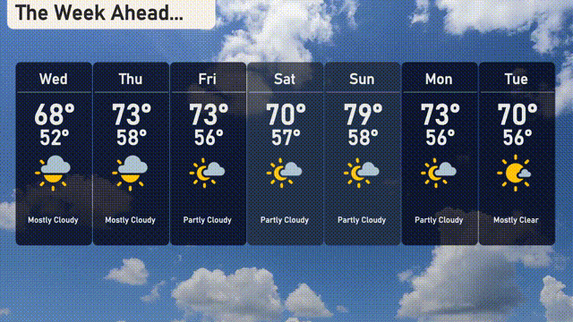
Wednesday: Mostly cloudy with a high of 68 degrees and a low of 52 degrees.
Thursday: Partly cloudy skies, warming up to a high of 73 degrees and a low of 58 degrees.
Friday: Expect more clouds with a high of 73 degrees, dipping to 56 degrees at night.
Saturday: Temperatures peak at 70 degrees under partly sunny skies, with a nighttime low of 57 degrees.
Sunday: Sunny and warm, reaching a high of 79 degrees and a low of 58 degrees.
Monday: Mostly cloudy with a high of 73 degrees and a low of 56 degrees.
Tuesday: A mostly clear day with temperatures reaching 70 degrees.