Navigating New York’s Nimbus: Amy Freeze’s Forecast Frontier
By
Amy Freeze
Dive into an in-depth weather overview with Amy Freeze, as she navigates the meteorological moods of New York City and beyond. From sunny highs to stormy lows, your comprehensive guide is here.
Amy Freeze provides today’s weather insights for NYC, covering the varying conditions from warm sunny skies to expected evening showers. Stay updated and prepared!
Welcome to your essential weather update with Amy Freeze. Today in NYC, enjoy partly cloudy skies with a high of 89°F. As the day progresses, anticipate increasing clouds and light showers. This evening, temperatures will cool slightly while rain chances intensify, especially in northern regions near Albany and Syracuse. Don’t forget to protect yourself from today’s high UV rays! Keep this page bookmarked for timely updates as conditions evolve. 🌧️🌤️
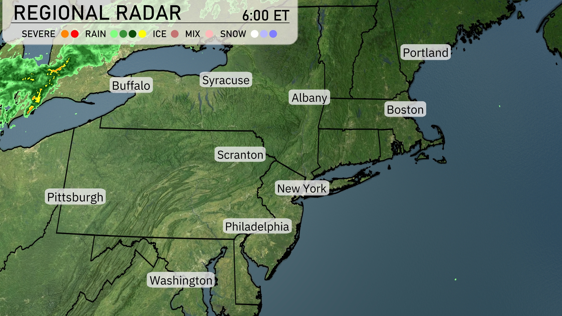
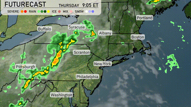
A line of storms is currently sweeping across the Great Lakes region, with heavier bands approaching Buffalo. Light rain extends into the Syracuse area, gradually moving eastward. Albany is on the cusp of receiving showers as the system progresses, while New York City and the southern states enjoy a break in precipitation under mostly clear skies. Portland and Boston are experiencing calm conditions with occasional cloud cover. The severe weather risk remains low across the Northeast, allowing for a relatively peaceful start to the day.
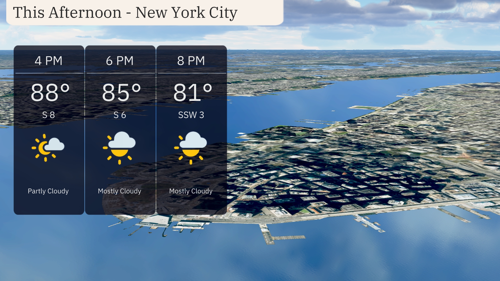
For New York City this afternoon, temperatures will start at 88 degrees at 4 PM, with a south wind blowing at 8 mph while skies remain partly cloudy. By 6 PM, expect the temperature to ease down to 85 degrees, and skies will become mostly cloudy with a south wind at 6 mph. Wrap up your day at 8 PM when temperatures drop to 81 degrees with mostly cloudy skies and a south-southwest wind at 3 mph.
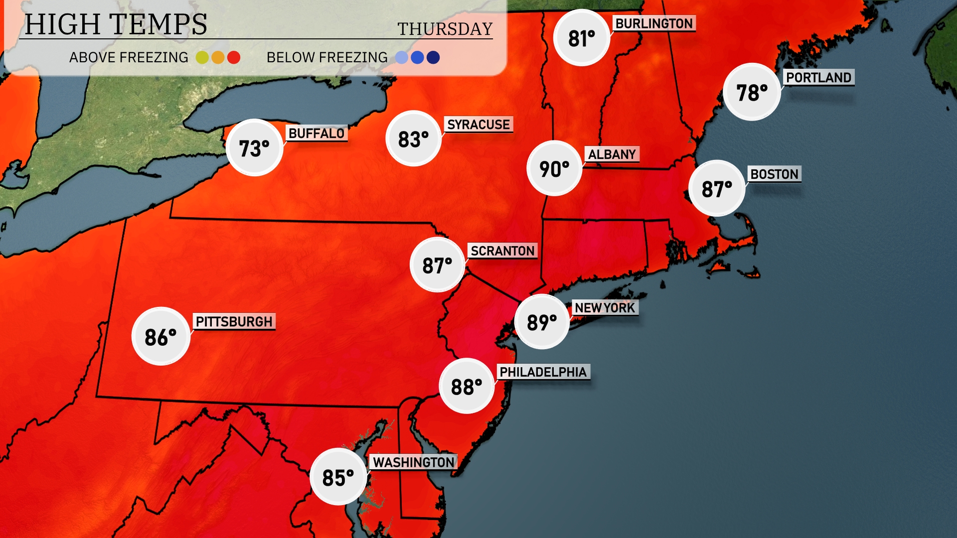
Afternoon temperatures across the Northeast are heating up today. New York City will see a high of 89 degrees, making for a warm day in the Big Apple. Philadelphia isn’t far behind with a high of 88, while Scranton will reach 87 degrees. Syracuse will also feel the warmth with a high of 83 degrees. Heading north, Buffalo is cool at 73 degrees, and Portland will see a pleasant high of 78 degrees.
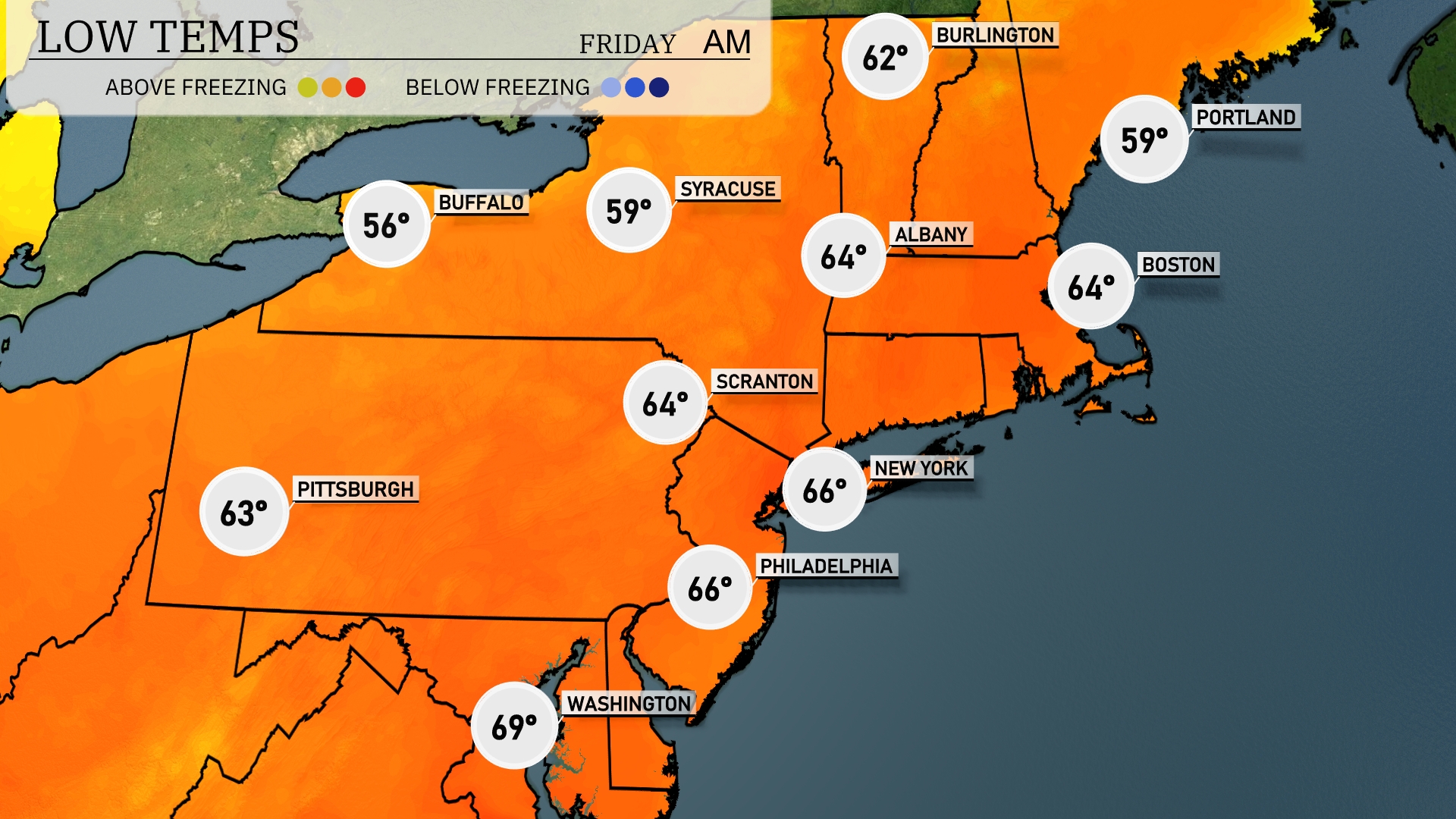
Tonight, temperatures across the Northeast will dip to 56 degrees in Buffalo and 59 degrees in Syracuse. Scranton will see a low of 64, while New York City is forecasted to cool down to 66 degrees. Boston is also expected to drop to 64, with Portland reaching a low of 59.
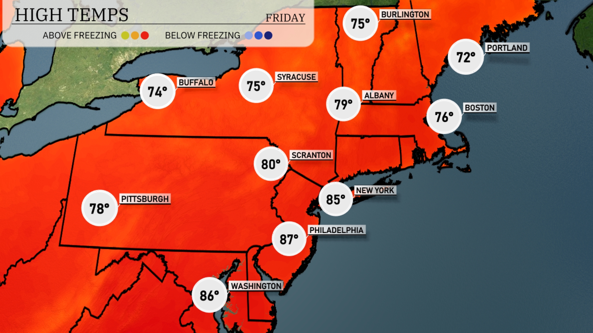
Tomorrow in the Northeast, Philadelphia will soar to a high of 87 degrees, feeling quite summer-like. New York City is expected to reach 85 degrees, while Scranton enjoys a warm 80 degrees. Boston will see a pleasant high of 76, and Syracuse will hit 75 degrees.
A frontal system will push through the Northeast tomorrow, bringing showers and thunderstorms from Pittsburgh to Albany, impacting areas like Syracuse and Scranton. Expect periods of heavy rain, which could lead to localized flooding, especially in low-lying areas. As the front moves east, New York and Philadelphia can anticipate rain late in the day, with clearing expected by evening. Temperatures will hover in the mid-70s, dropping slightly as the front passes.
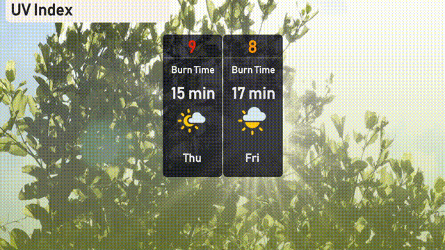
New York City will experience a very high UV index of 9 today, June 5, with a burn time of approximately 15 minutes under direct sunlight. It’s essential to apply broad-spectrum sunscreen and wear protective clothing if you’ll be outdoors. Looking ahead to tomorrow, the UV index is slightly lower at 8, with a burn time of 17 minutes, still necessitating sun safety measures.