From Serene Skies to Storm Alerts: NYC’s Dramatic Weather Shift
By
Amy Freeze
Explore the transformative weather journey of NYC this week from tranquil evenings to stormy forecasts with Meteorologist Amy Freeze.
Catch the latest NYC weather forecast with Amy Freeze! From balmy evenings to stormy afternoons, know what’s coming up in your city!
Meteorologist Amy Freeze presents a comprehensive look at NYC’s weather this week with clear evenings and upcoming storm threats. Dive into day-by-day forecasts, temperature trends, and storm warnings to stay fully prepared. Whether planning an outing or just going about your daily activities, keep ahead of the weather changes in New York City.
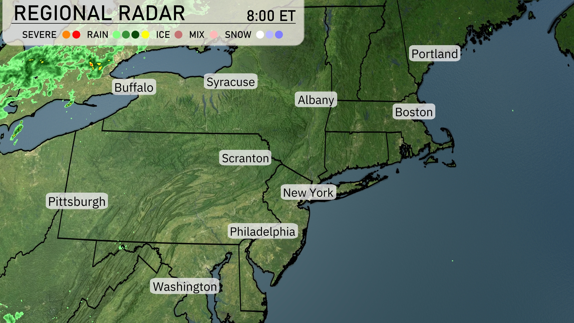
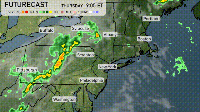
Rain showers are currently pushing across the Great Lakes, extending into western areas of New York, around Buffalo. This precipitation band is set to advance northeastward, potentially reaching into central New York and western Pennsylvania. Cities like Albany, Syracuse, and Scranton are experiencing mostly clear skies. Conditions in coastal areas, including Boston and New York City, remain dry and clear for now. A mix of clouds and sun is anticipated throughout the Northeast as the day progresses.
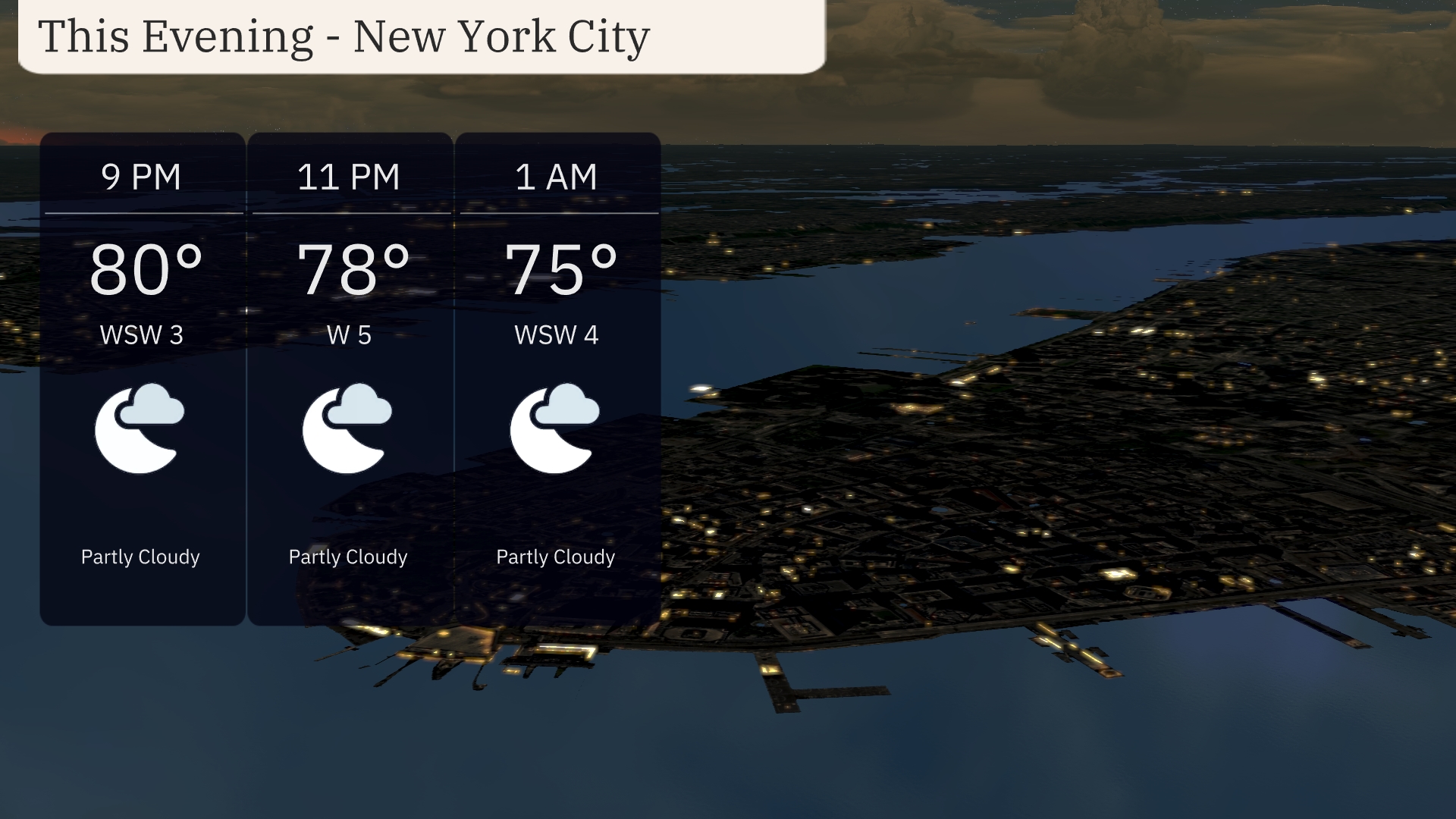
For the evening in New York City, expect partly cloudy skies with temperatures beginning at 80 degrees at 9 PM and gradually cooling to 75 degrees by 1 AM. Winds will be light, coming from the west-southwest at speeds of 3 to 5 miles per hour.
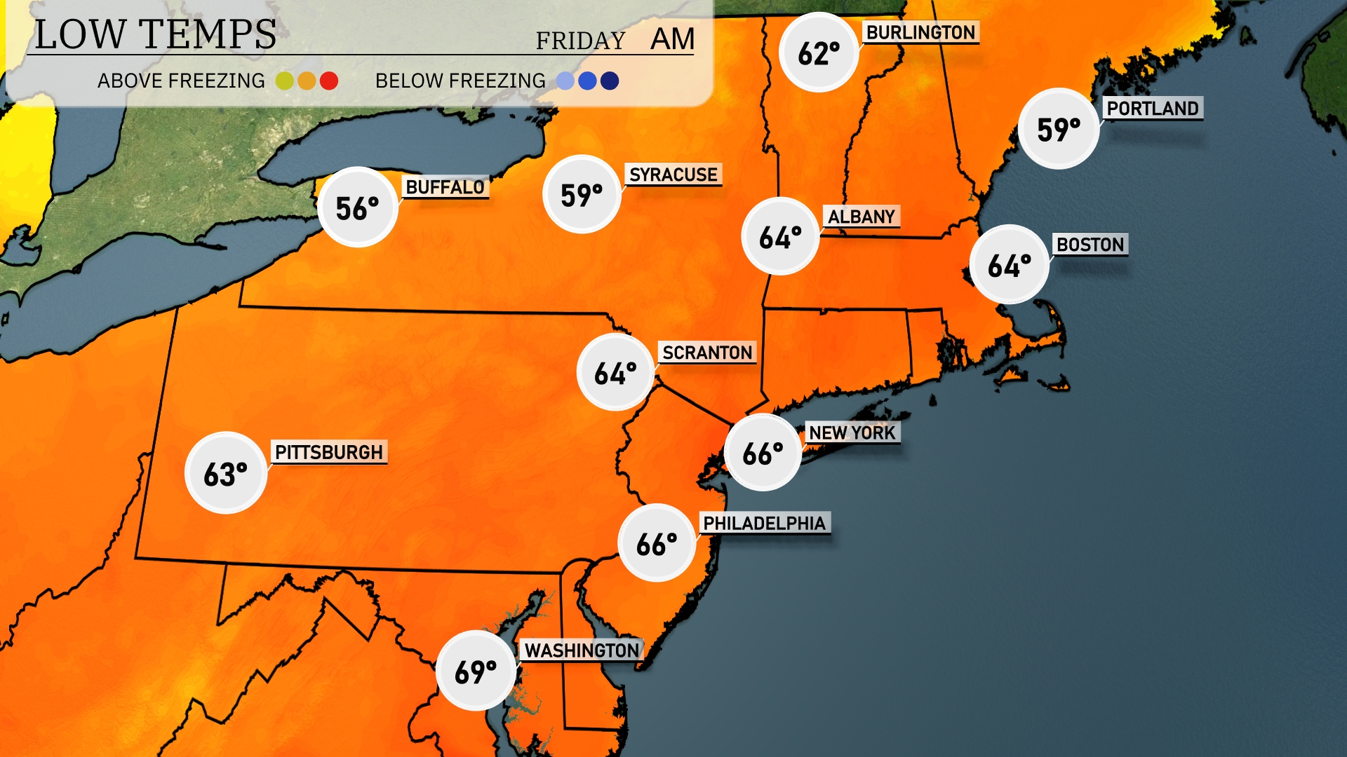
Tonight in the Northeast, expect temperatures to drop noticeably. Buffalo will see a low of 56 degrees, while Syracuse dips to 59. In the southern tier, Scranton and Philadelphia both forecast lows of 64 degrees. New York City is slightly warmer at 66 degrees, reflecting the milder conditions along the coast. Boston is also expecting a low of 64 degrees, with Portland cooling down to 59.
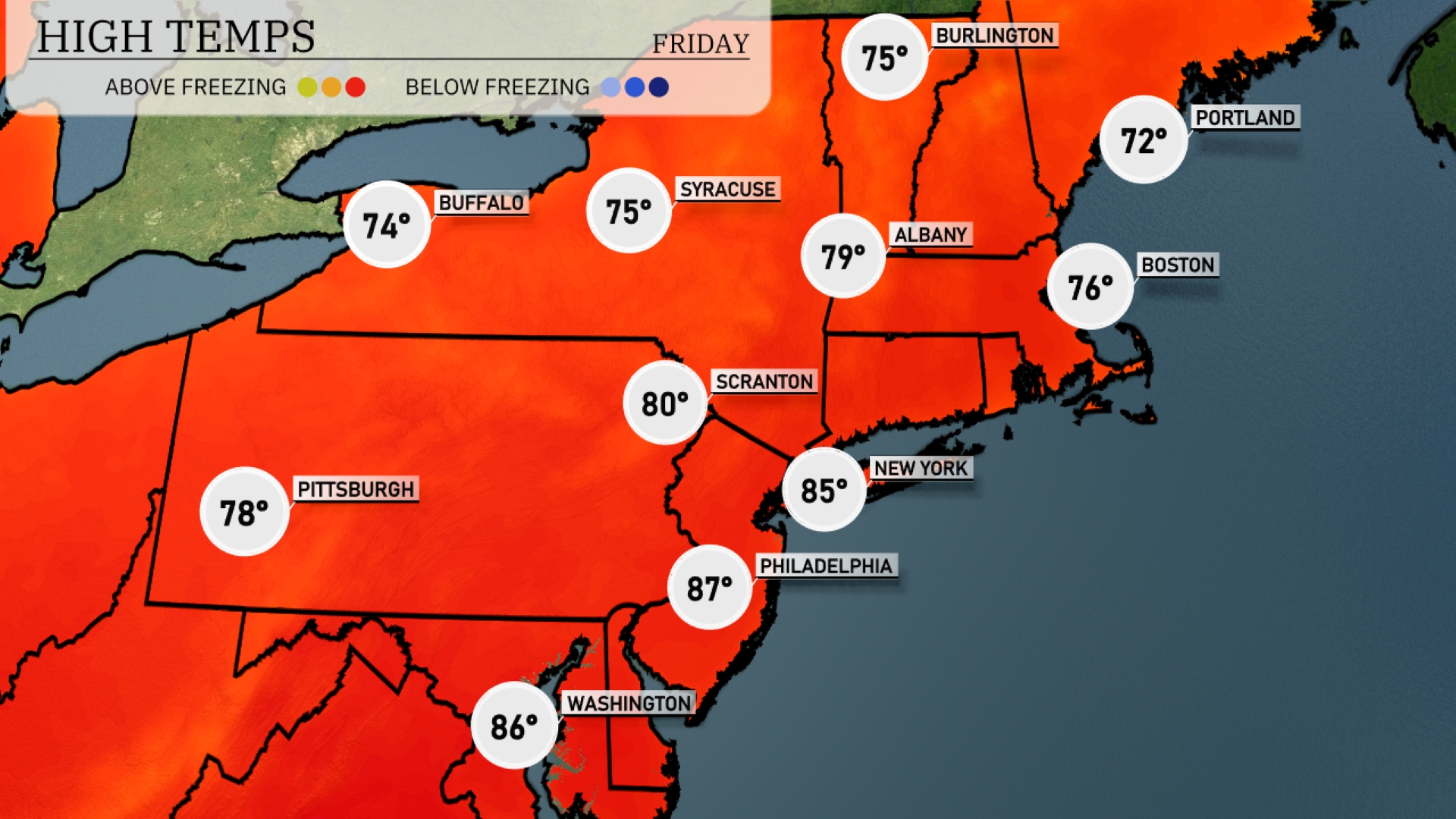
Tomorrow in the Northeast, expect temperatures to soar with Philadelphia leading the way at 87 degrees. New York City will reach 85, while Scranton is not far behind at 80 degrees. Pittsburgh will see a high of 78 degrees, and Buffalo is looking at a comfortable 74.
A cold front will push through the Northeast tomorrow, bringing a line of storms from Pittsburgh to Syracuse and into Albany by the late morning hours. Expect heavy rain and gusty winds, especially from Philadelphia to New York City during the afternoon. There’s a potential for severe storms in isolated areas, so stay weather alert. Temperatures will cool down significantly behind the front, bringing a much-needed break from the recent warm spell. Lingering showers may affect Boston and parts of New England through the evening hours.
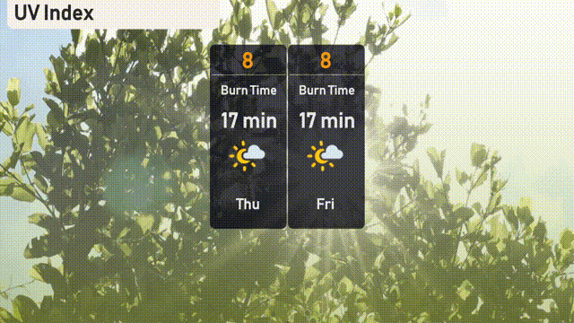
The UV index in New York City is set to be very high at 8 for both Thursday and Friday, with sun exposure leading to potential burn times of just 17 minutes.
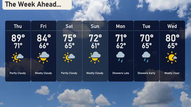
Thursday: Partly cloudy with a high of 89 degrees and a low of 71 degrees.
Friday: Mostly cloudy skies, with highs reaching 84 degrees and cooling down to 66 degrees at night.
Saturday: Expect partly cloudy conditions and a cooler day, with a high of 75 degrees and a low of 65 degrees.
Sunday: Mostly cloudy with temperatures peaking at 72 degrees and dipping to 61 degrees overnight.
Monday: Showers late in the day, with a high of 71 degrees and a low of 62 degrees.
Tuesday: Early showers expected, with temperatures rising to 70 degrees during the day and a low of 65 degrees.
Wednesday: Mostly clear skies, warming up with a high of 80 degrees and a low of 65 degrees.