Miami’s Melody of Weather: A Symphony of Sun & Storms
By
Amy Freeze
Discover the intricate dance of weather patterns from sunny Miami to stormy Shreveport. Dive into today's weather dynamics across the Southeast, from clear skies to brewing storms!
Get the latest on Miami’s weather: from an 87°F high today to a week of sun and potential storms. Dive deeper into what these weather changes mean for you!
This week in Miami, we’re navigating a rollercoaster of weather conditions. With temperatures marching up to 87 degrees and dipping to nightly lows of 78, Miami’s climate offers everything from sunny to stormy scenes. Across the Southeast, temperatures are soaring, posing challenges and surprises. Tomorrow’s forecast predicts intense activity with prospects of rain and cooling breezes by the weekend. Stay updated with our comprehensive 7-day forecast and in-depth insights into each day’s weather dynamics here on our blog.
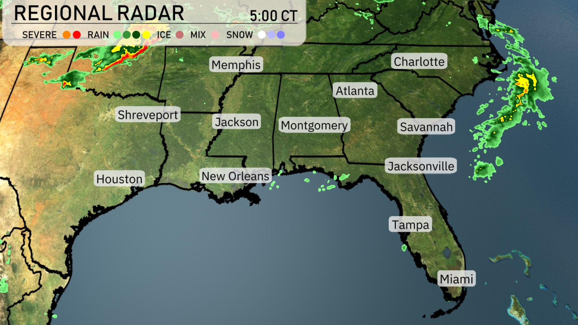
The Southeast radar shows a mix of conditions today. Storms are intensifying over parts of eastern Texas, with their trajectory aimed toward Shreveport, potentially bringing severe weather. Showers are spreading across northern Mississippi and Alabama, making their way towards Atlanta. The coastal regions from Savannah to the Carolinas are seeing isolated rain, creating a mixed weather tapestry for the day ahead.
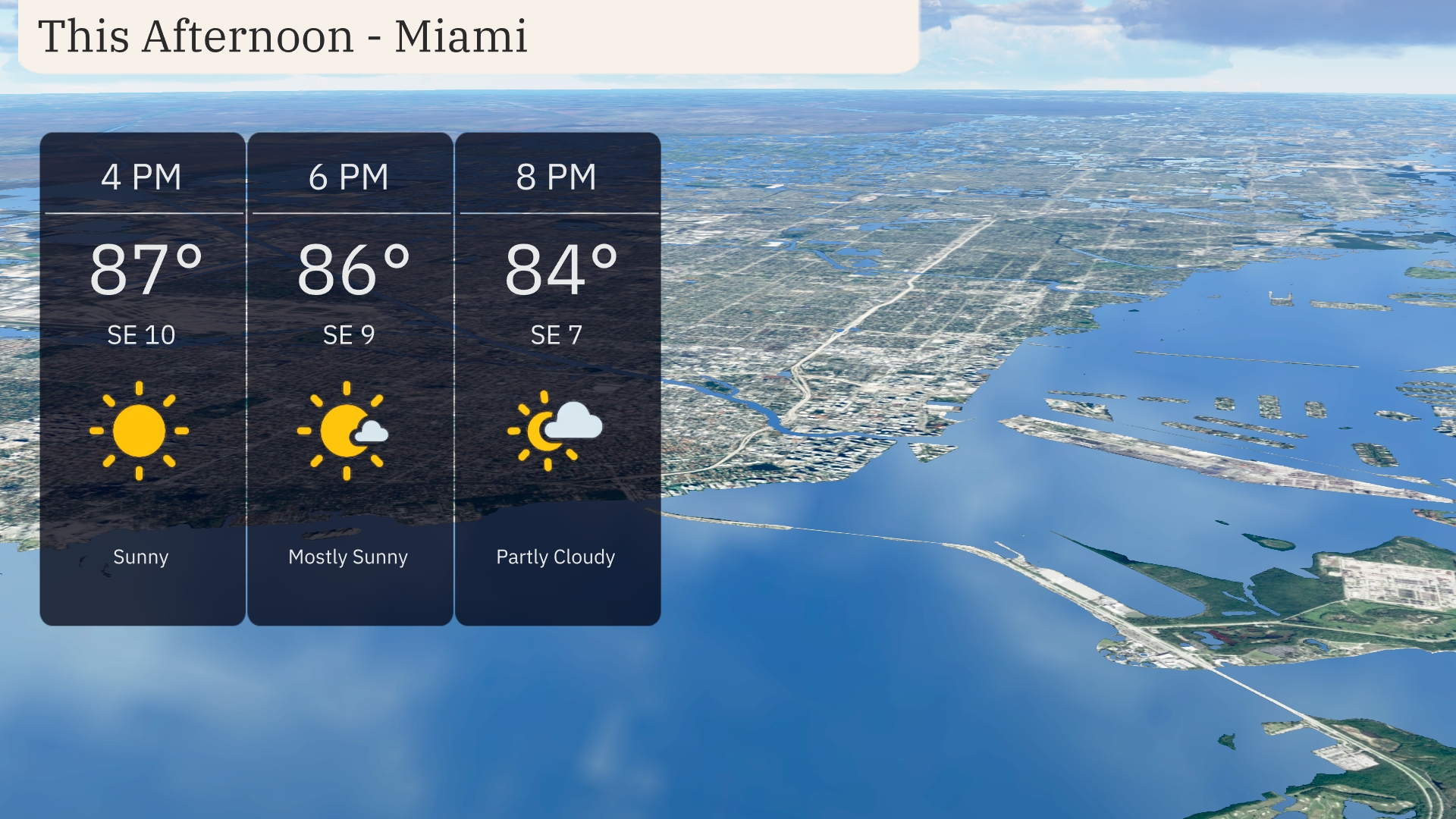
Temperatures in Miami this afternoon reach 87 degrees by 4 PM, dipping slightly to 84 degrees by 8 PM. Winds remain steady from the southeast at around 10 miles per hour, providing a gentle breeze. Expect plenty of sunshine initially, transitioning to mostly sunny and then partly cloudy conditions as the evening approaches.
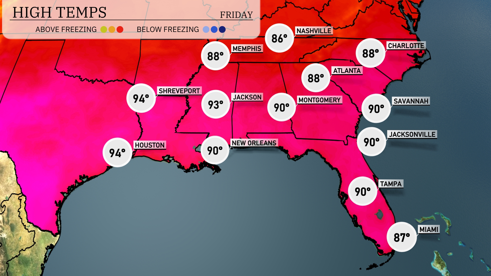
In the Southeast today, temperatures are soaring. In Shreveport and Houston, we’re looking at a warm high of 94 degrees. Jackson is slightly cooler at 93, while New Orleans and Montgomery reach 90. Over in Florida, both Tampa and Jacksonville will also hit 90 degrees, but Miami is a bit cooler at 87. Atlanta and Savannah enjoy highs around 88 and 90 degrees, respectively, bringing a mix of sunshine and warmth across the region.
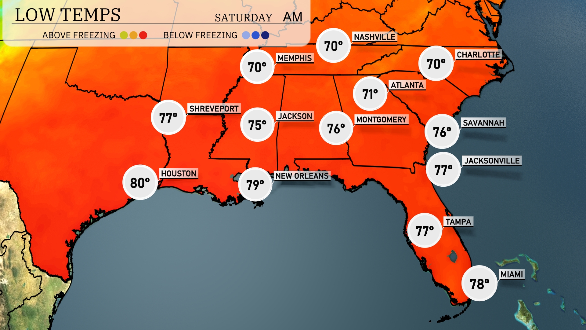
Tonight, expect a low of 70 degrees in Memphis and Nashville. Montgomery will dip to 76, while Jackson sees a low of 75. In Florida, Jacksonville and Tampa will both settle at 77 degrees, with Miami remaining mild at 78. Shreveport may also feel relatively warm at 77 degrees.
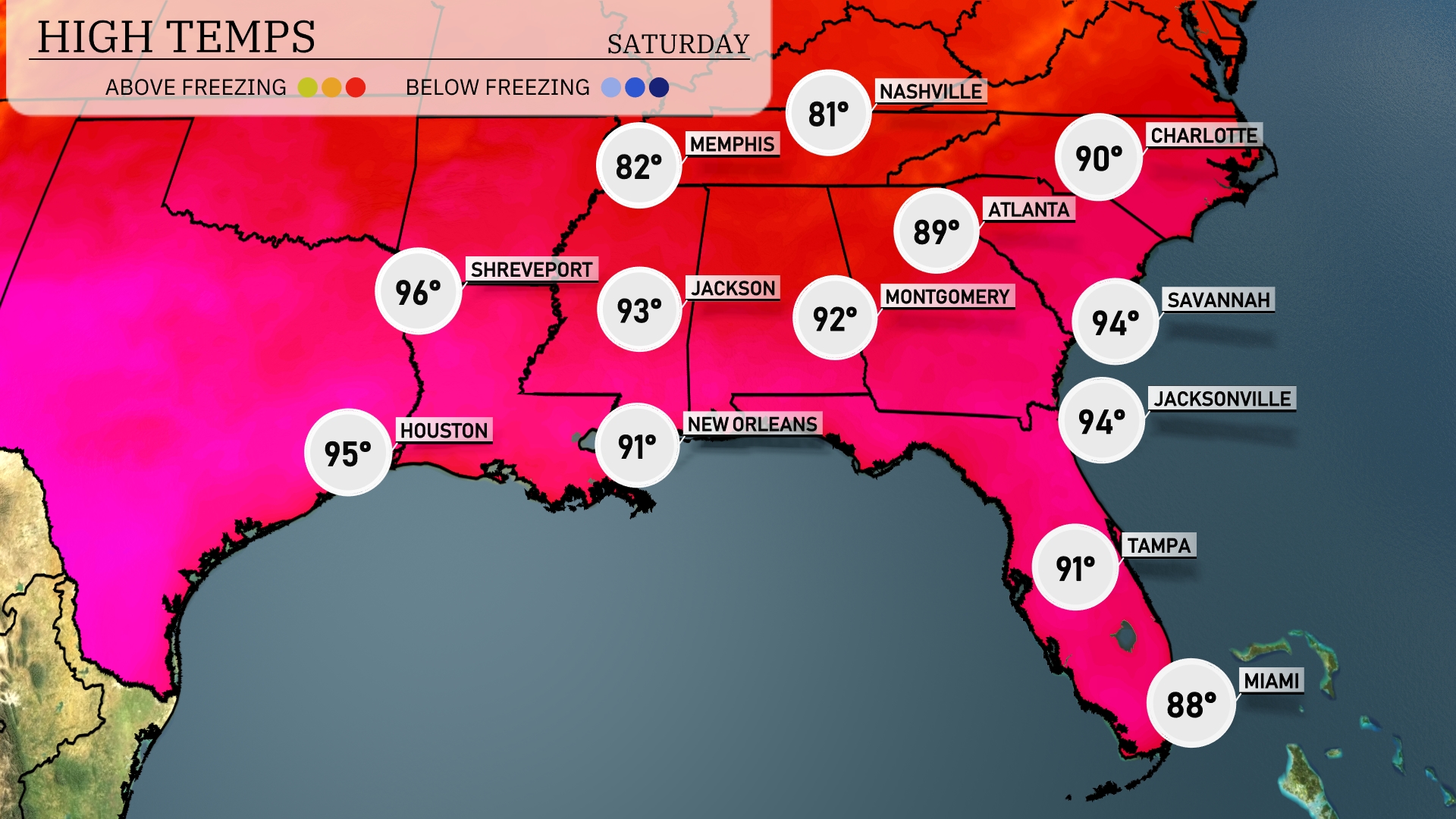
Tomorrow in the Southeast, temperatures will soar with highs expected to reach 96 degrees in Shreveport and 95 degrees in Houston. Jacksonville and Savannah are set for a warm 94 degrees, while Atlanta hits 89 degrees. Montgomery is forecasted at 92 degrees, and New Orleans will see a high of 91 degrees.
A cold front brings active weather to the Southeast tomorrow. Look for showers and thunderstorms from Houston to Jacksonville, with the heaviest rain concentrated in Mississippi and Alabama, potentially causing localized flooding. As the front approaches Memphis by midday, expect a line of storms through Atlanta by late evening. Breezy conditions may accompany these storms, leading to some power outages. Behind the front, cooler, drier air will filter in, bringing a refreshing change to the weather by the weekend.
The UV index in Miami today is extremely high at 11, with a burn time of just 11 minutes under direct sunlight.