From Clear Evenings to Severe Showers – Atlanta’s Weather Rollercoaster
By
Amy Freeze
Explore the drastic weather changes sweeping through Atlanta and the Southeast, from serene starry skies to severe thunderstorms, all in our latest update.
Tonight in Atlanta, enjoy starry skies before showers and storms roll in. Stay updated with our comprehensive weather forecast for the Southeast!
This week, Atlanta and the Southeast are on a weather rollercoaster from starry nights to severe storms. Read our day-by-day forecast and prepare for shifts from high temperatures to stormy evenings with potential flooding. Don’t miss our safety tips and updates on https://amyfreeze.ai/
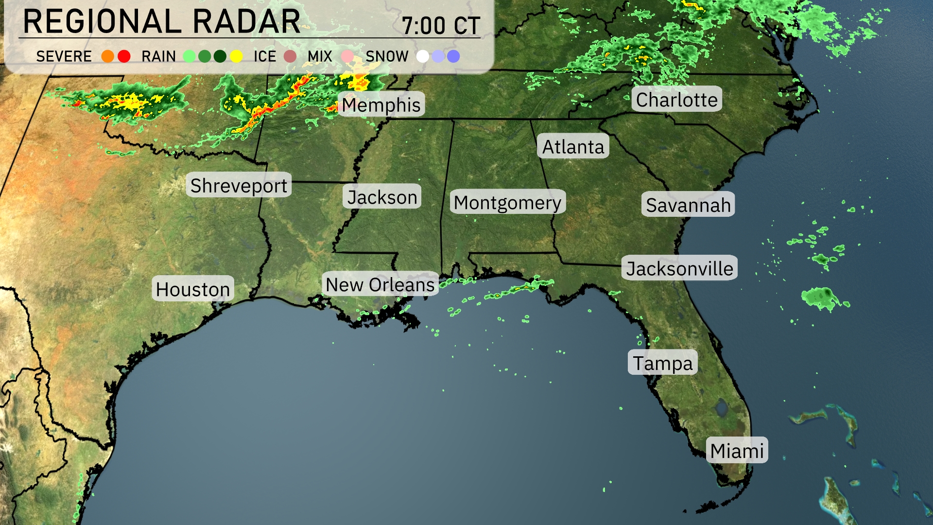
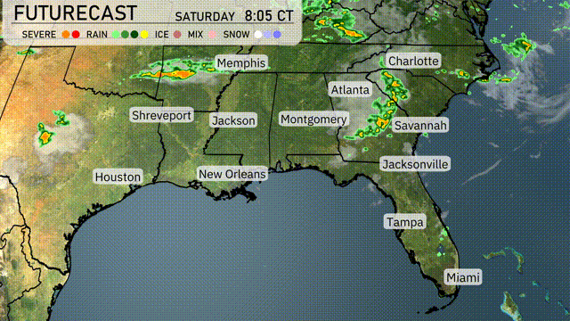
Showers are developing over the Southeast, with significant rainfall stretching from Shreveport advancing toward Memphis, indicating potential for thunderstorms in these areas. Cloud cover is thickening towards Jackson, aiming eastwards into Georgia and the Carolinas. In New Orleans, scattered showers are likely, with moisture pushing northeastward across Mississippi. Meanwhile, Charlotte and Atlanta remain currently dry, but rain is expected to move in soon.
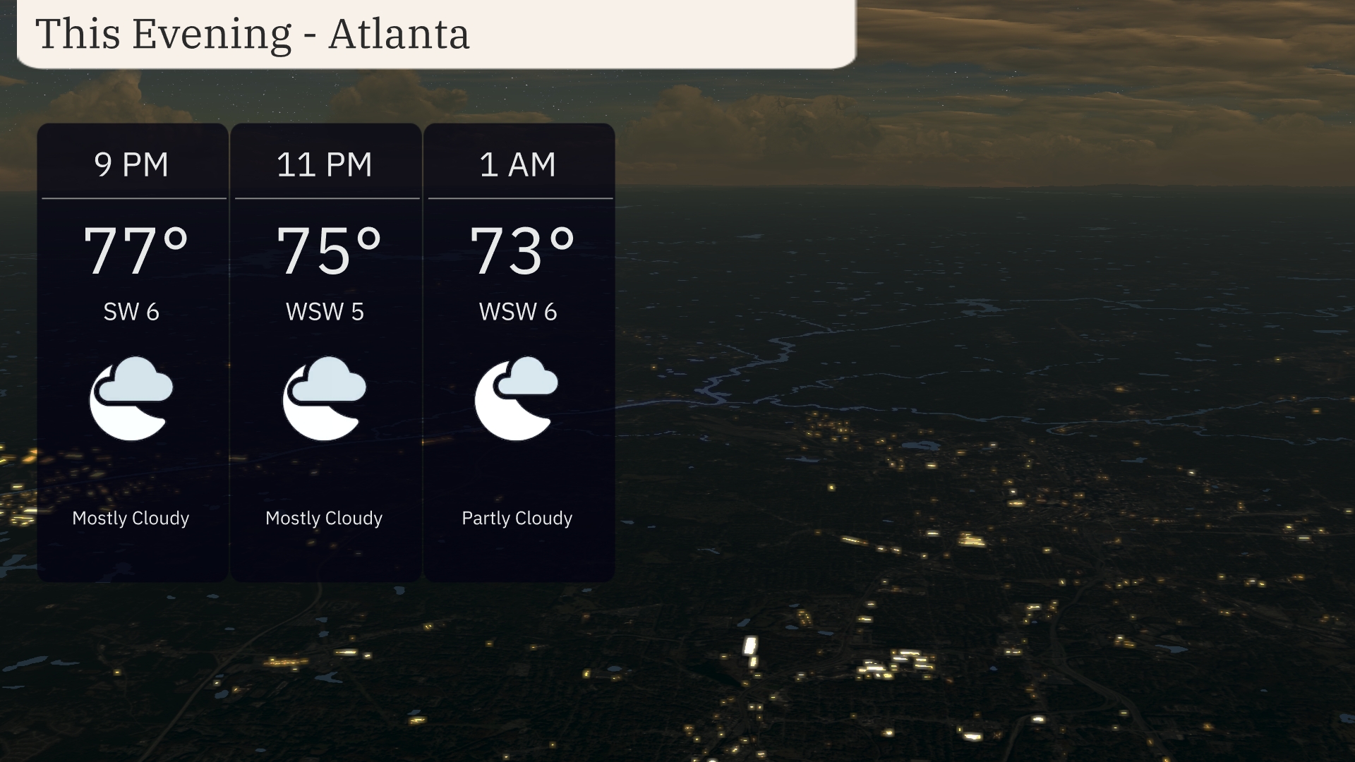
For this evening in Atlanta, anticipate mostly cloudy skies, with temperatures steadily decreasing from 77 degrees at 9 PM to 73 degrees by 1 AM. Winds will remain gentle from the southwest at 5 to 6 miles per hour. Enjoy a pleasant and calm night ahead.
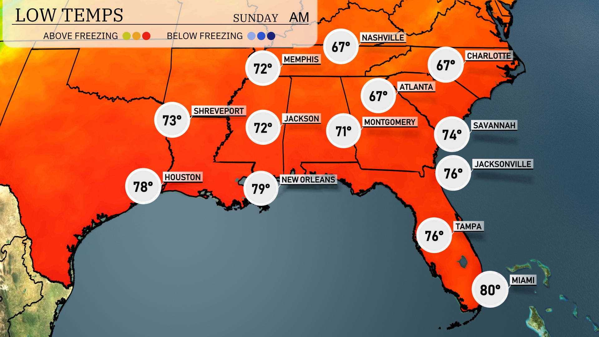
Tonight, low temperatures across the Southeast will range from the mid-60s to upper 70s. In Nashville and Montgomery, expect lows around 67 degrees. Jackson will cool down to 72, while Shreveport is also looking at a low of 73. Southern cities such as New Orleans will be warmer at 79 degrees, and Miami remains mild at 80.
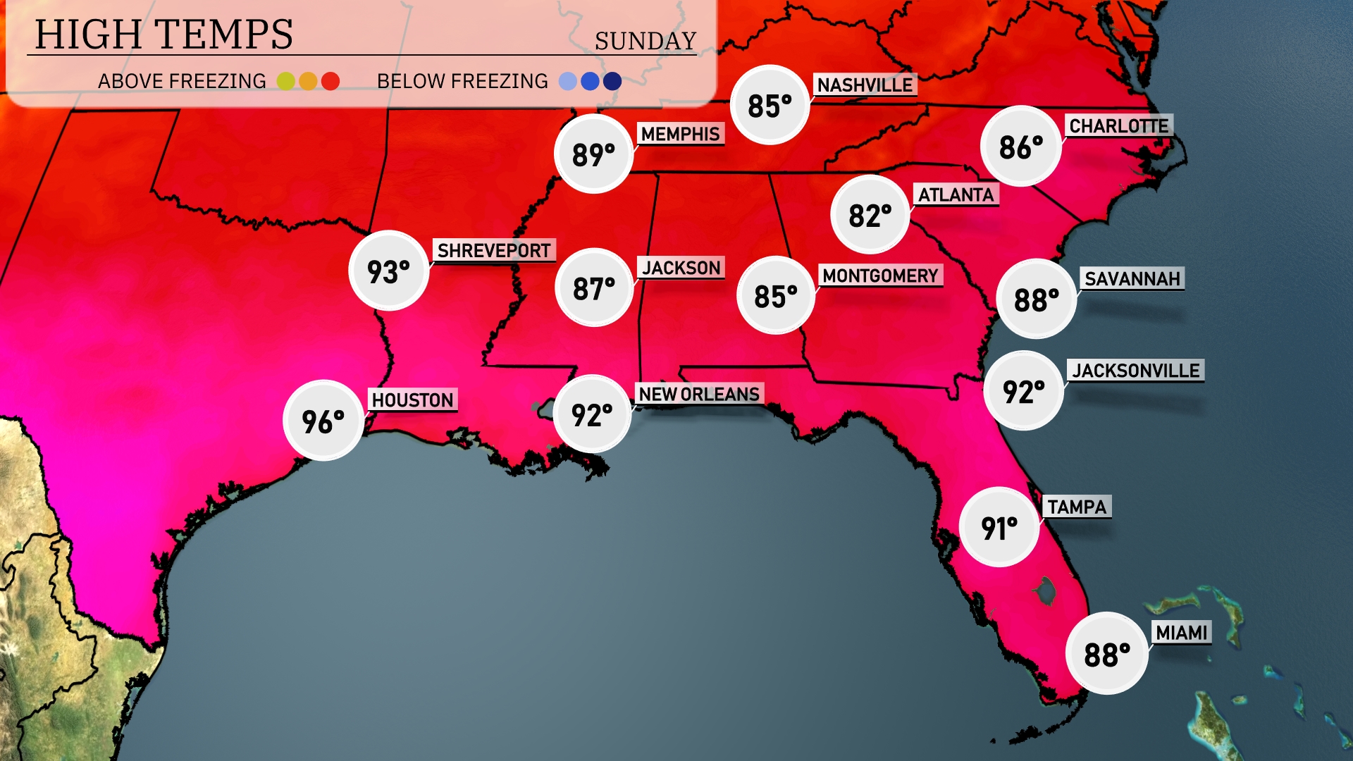
Tomorrow in Houston, temperatures are set to soar to a scorching 96 degrees, well above average for this time of year. New Orleans will also experience warm weather, with a high of 92 degrees. In the eastern part of the Southeast, Jacksonville is forecasted to hit 92, while Tampa will reach a balmy 91 degrees. Atlanta will see a pleasant high of 82 degrees, slightly cooler due to nearby cloud cover. Expect Memphis at 89 and Montgomery at 85.
A cold front moves into Georgia on Sunday evening, bringing showers and storms from New Orleans to Montgomery, with Atlanta experiencing rain during the afternoon. Storms will develop over Charlotte and Savannah, and severe weather is possible in northeast Georgia. Watch for heavy downpours and localized flooding as more than an inch of rain accumulates. Temperatures will drop significantly following the front, with cooler weather expected by Monday.
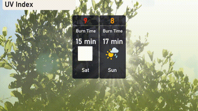
The UV index in Atlanta on Saturday will be very high at 9, suggesting a burn time of only 15 minutes under direct sunlight. On Sunday, the UV index drops slightly to 8, with a burn time of 17 minutes, though brief showers may offer some respite from the sun.
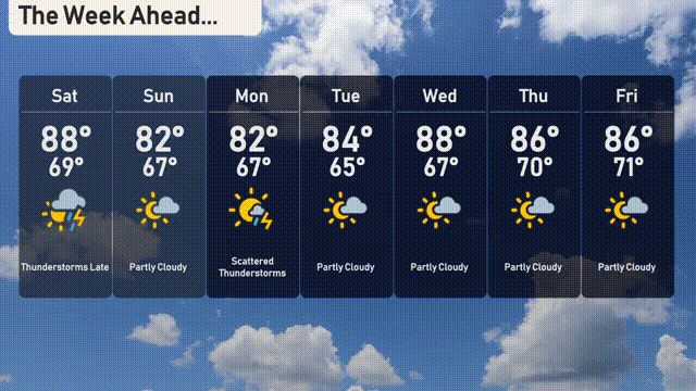
For the 7-day forecast in Atlanta:
Saturday: Thunderstorms late with a high of 88 degrees and a low of 69.
Sunday: Expect partly cloudy skies with a high of 82 degrees and a low of 67.
Monday: Scattered thunderstorms with temperatures reaching a high of 82 degrees and a low of 67.
Tuesday: Partly cloudy conditions and a high of 84 degrees, the low is 65.
Wednesday: More sunshine with partly cloudy skies, the high is 88 degrees, and the low is 67.
Thursday: Another day of partly cloudy skies, with the temperature peaking at 86 degrees and a low of 70.
Friday: Partly cloudy once more, reaching a high of 86 degrees and a low of 71.