Chicago’s Weather Dance: Sun, Clouds, and Storm Alerts
By
Amy Freeze
Explore the diverse weather spectrum hitting Chicago and nearby areas – from partly cloudy skies and gentle breezes to imminent storm threats and temperature dips.
Get the scoop on Chicago’s shifting weather, from delightful 74°F afternoons to cooler nights and potential severe weather alerts. Tune into our detailed 7-day forecast!
Chicago and its surrounding areas are on a weather rollercoaster! This week, experience everything from comfy 74-degree highs to imminent storms. What’s causing these swings, and how can residents best prepare? Join us as we navigate through dynamic forecasts, temperature shifts, and safety guidelines, all tailored to keep you informed and ready.
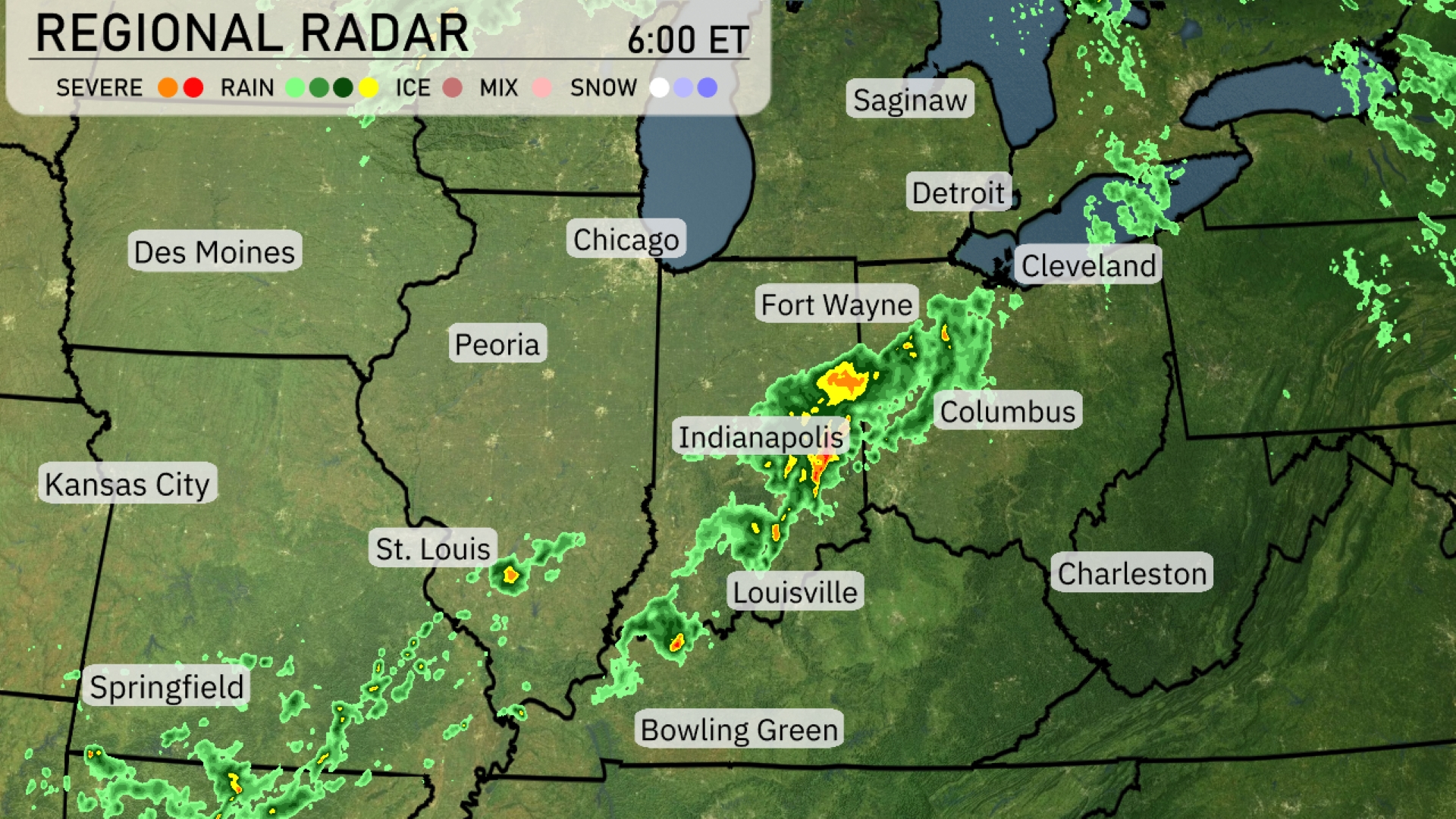
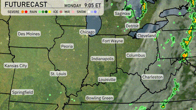
A line of thunderstorms is making its way through the Ohio Valley, stretching from Fort Wayne down to Louisville and Bowling Green. Indianapolis is currently experiencing moderate rain, with some intense storm activity approaching. Cincinnati and Columbus can expect this weather system to hit, bringing showers and possible thunderstorms. Areas like Chicago and Detroit remain under cloud cover but largely dry as the rain band stays to their south.
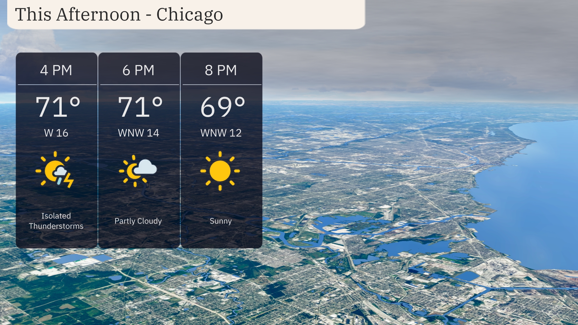
For Chicago this afternoon, expect temperatures holding steady at 71 degrees around 4 PM, with winds coming from the west-northwest at 16 miles per hour. By 6 PM, the skies will be partly cloudy, while temperatures remain at 71 degrees and the wind continues at 14 miles per hour. As we move into 8 PM, enjoy clear skies with temperatures dipping slightly to 69 degrees and winds calming to 12 miles per hour.
This afternoon, the Midwest is experiencing a warm day with some notable temperature variations. Kansas City peaks at a toasty 80 degrees, while St. Louis is close behind at 82. Heading northeast, Peoria and Fort Wayne enjoy highs of 77 degrees, and Indianapolis is slightly cooler at 76. Columbus stays relatively mild at 69, contrasting sharply with Charleston, which is warming up to 84 degrees. Chicago remains comfortable at 74, offering a pleasant day across the region.
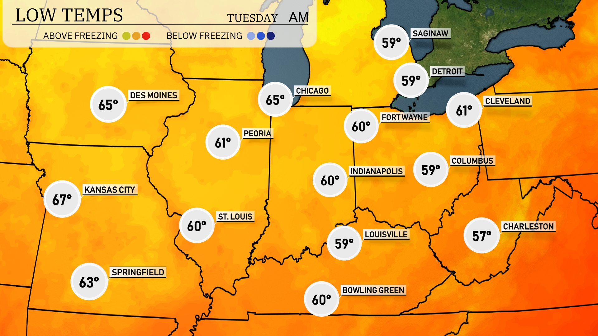
Tonight, Chicago will cool down to 65 degrees, while Des Moines follows closely with a low of 65 as well. Indianapolis and Fort Wayne are expected to drop to 60 and 59 degrees, respectively. In the southern region, Louisville will see a low of 59 degrees, and Charleston is forecasted to reach 57 degrees overnight.
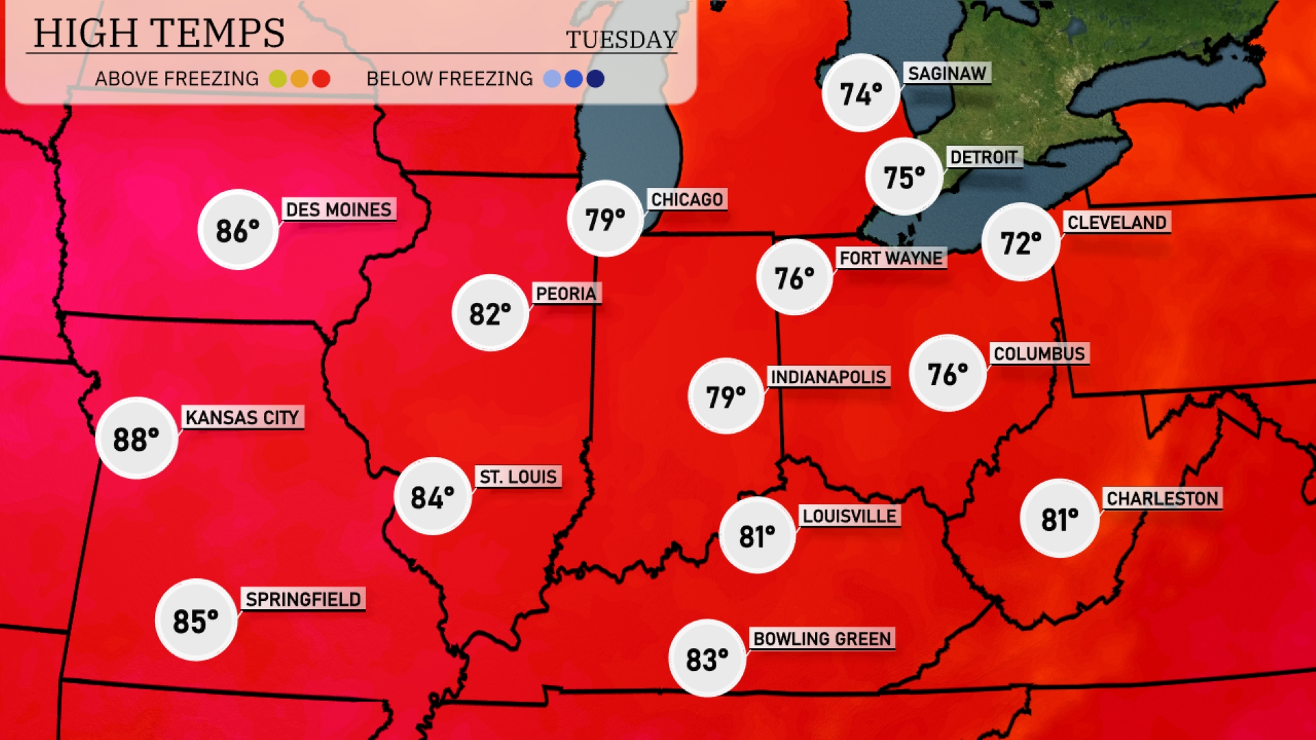
Tomorrow, Kansas City will experience a warm high of 88 degrees, while St. Louis warms up to 84. In the eastern part of the region, Louisville is expected to reach 81 degrees and Indianapolis will see a comfortable 79. Farther north in Chicago, highs are forecasted at 79 degrees, and Fort Wayne will tap out at 76. Overall, temperatures are running above average for this time of year due to a strong high-pressure system dominating the Midwest.
A cold front is expected to move through the Midwest tomorrow, bringing rain and possibly severe weather. From Des Moines to Indianapolis, anticipate heavy showers and isolated thunderstorms during the day. Temperatures will cool following the front’s passage, dropping approximately 5 to 10 degrees by late Tuesday. Windy conditions in Chicago and Peoria could pose challenges, so hold onto those hats. By late evening, conditions should begin to clear, setting up for a calmer midweek.
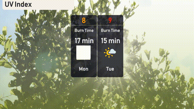
The UV index in Chicago will peak at 8 on Monday, with a burn time of about 17 minutes in direct sunlight. By Tuesday, the UV index rises to 9, shortening the burn time to 15 minutes. Remember to use sunscreen, cover up, and seek shade during peak hours to protect your skin!