Sunny Miami & Stormy Southeast: A Comprehensive Weather Guide
By
Amy Freeze
Explore the dynamic weather patterns affecting Miami and the Southeast, from sunny skies in Miami to storm alerts across the region.
This week in Miami, enjoy partly cloudy skies with gentle breezes, amidst fluctuating weather patterns across the Southeast. Learn more about how these changes could impact your week.
In Miami, residents will enjoy stable temperatures and mostly sunny skies, while the broader Southeast faces a mix of severe storms and pleasant weather. Detailed temperature readings and forecasts for regions including Houston, Atlanta, and New Orleans are featured, along with safety tips for impending storms. Make sure to stay updated with our daily and weekly forecasts to navigate through these varied weather conditions effectively.
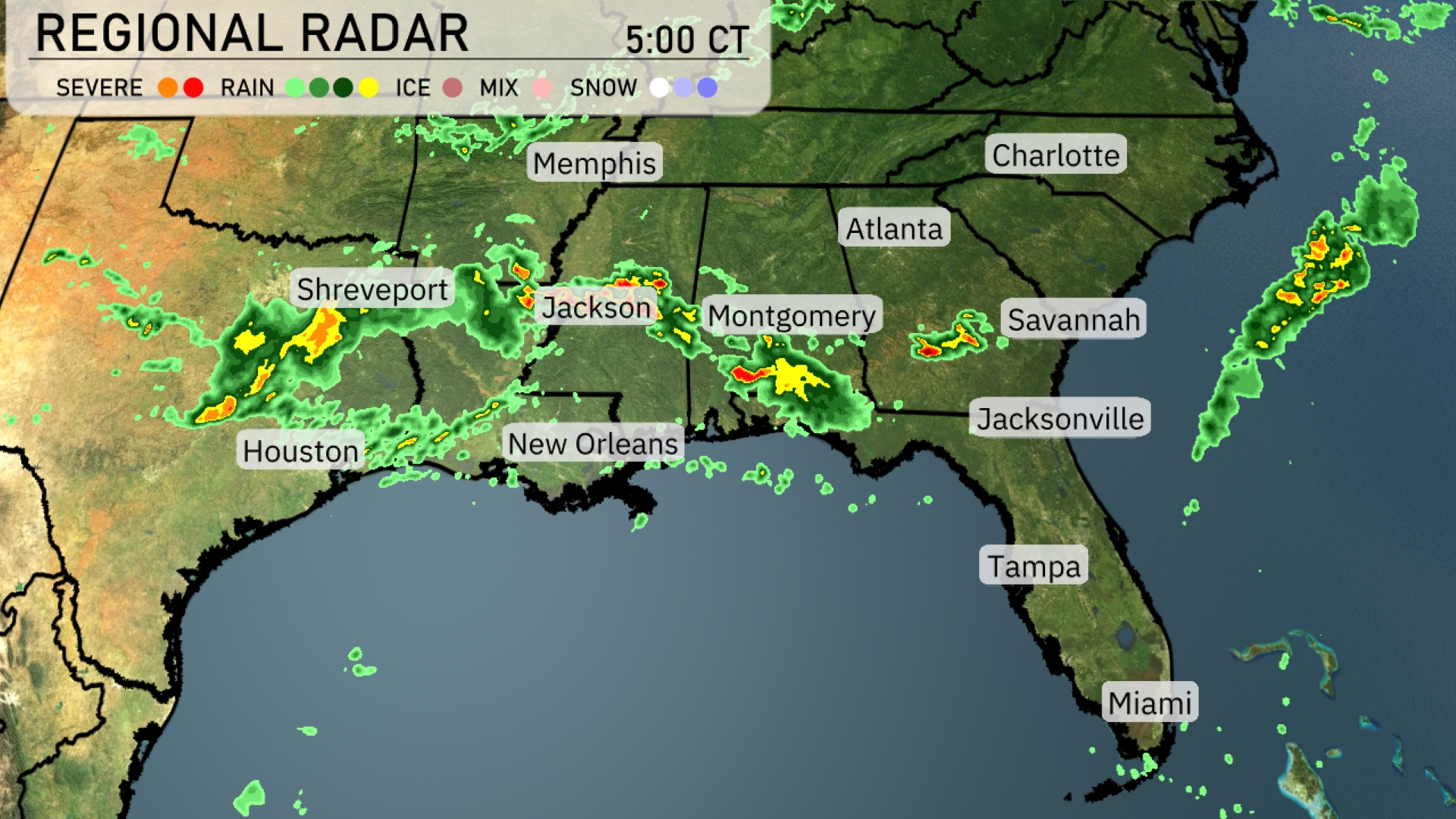
A line of storms is sweeping across the Southeast, particularly affecting regions from Shreveport to Montgomery, with heavy rain and possible severe weather noted. Jackson is currently experiencing intense rain, and those areas need to stay alert as the storms move eastward. In the Carolinas and Georgia, spotty showers are developing with clouds moving ahead of these systems, indicating future rainfall. The coastlines around Tampa and Miami appear clear with calmer weather conditions.
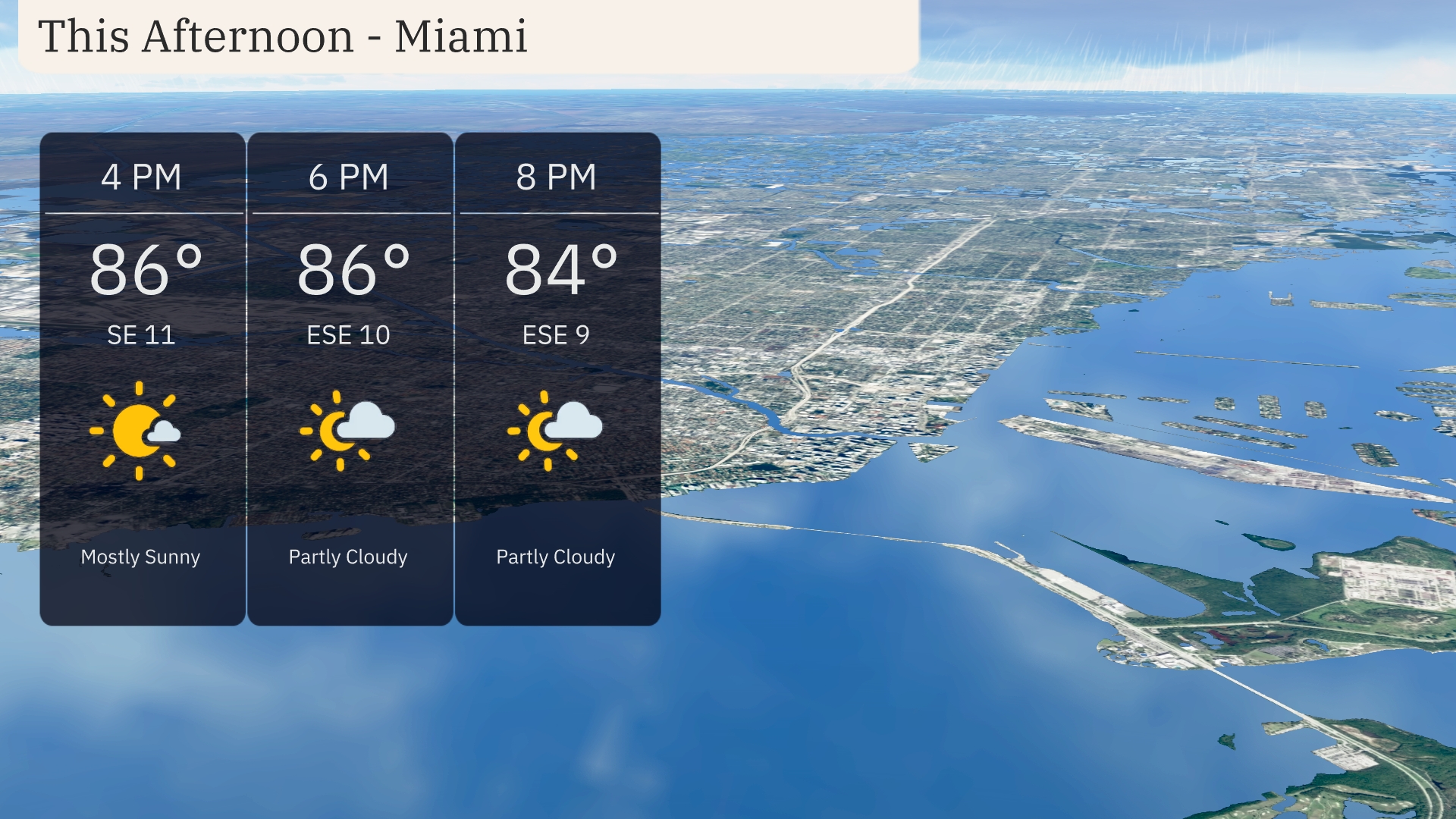
Afternoon temperatures in Miami hold steady at 86 degrees with partly to mostly sunny skies. Expect a gentle breeze from the east-southeast at 11 miles per hour. As evening approaches, temperatures will only slightly dip to 84 degrees by 8 PM, maintaining the partly cloudy conditions.
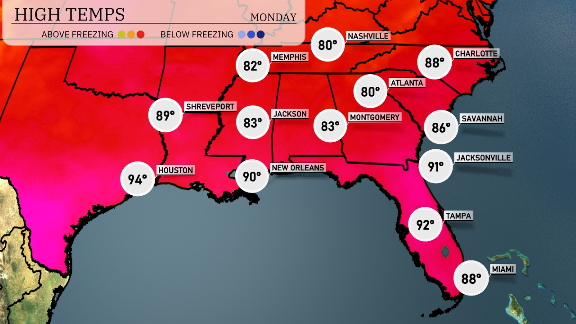
In the Southeast today, we’re seeing quite a range in temperatures. Houston is leading the pack with a sizzling high of 94 degrees, while New Orleans follows closely at 90. Temperatures are more moderate in Atlanta and Montgomery, both reaching around 83 degrees. Jacksonville is comfortably warm at 91, as Savannah hits a pleasant 86. As we head towards Florida’s west coast, Tampa logs in at a hotter 92 degrees, cooling slightly to 88 in Miami.
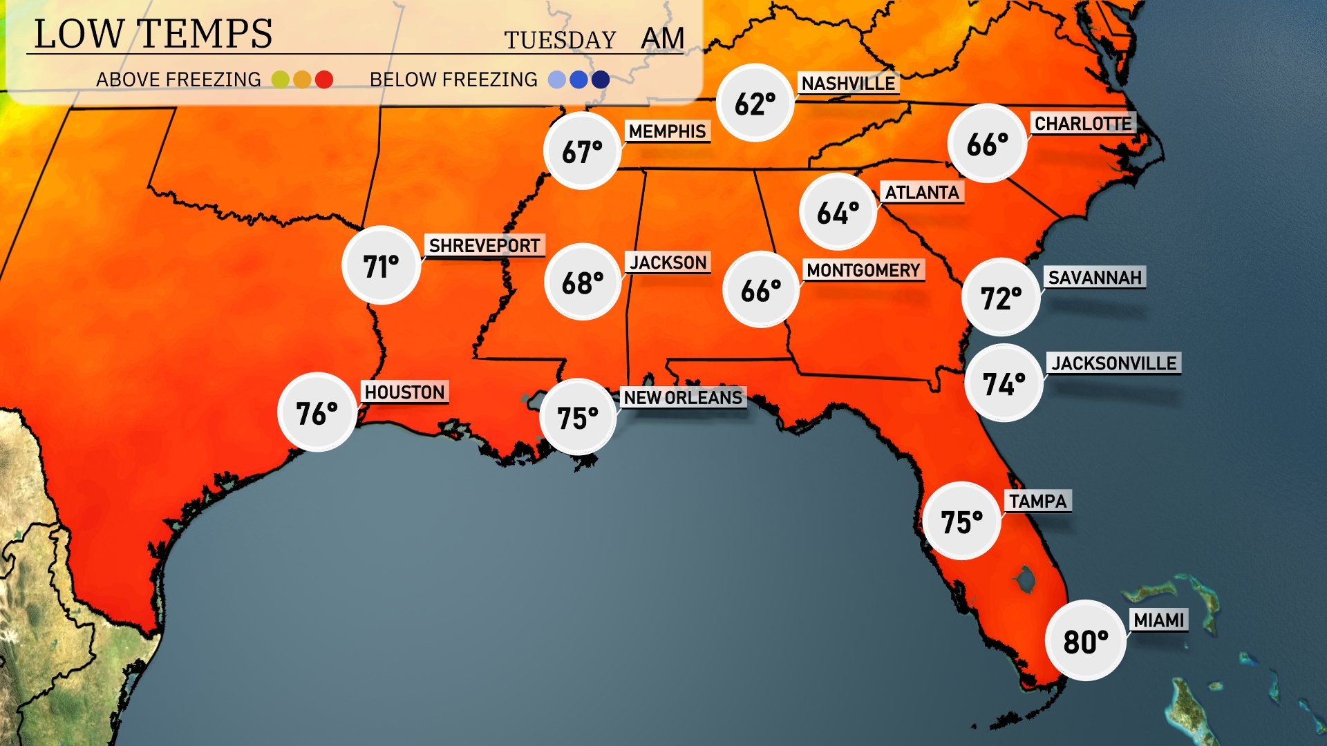
Tonight, expect lows to dip to 62 degrees in Memphis and 64 degrees in Nashville. Montgomery will see a cooler night at 66 degrees, while Atlanta will register a low of 64. Farther south, temperatures remain milder with New Orleans at 75 degrees and a warm 80 in Miami.
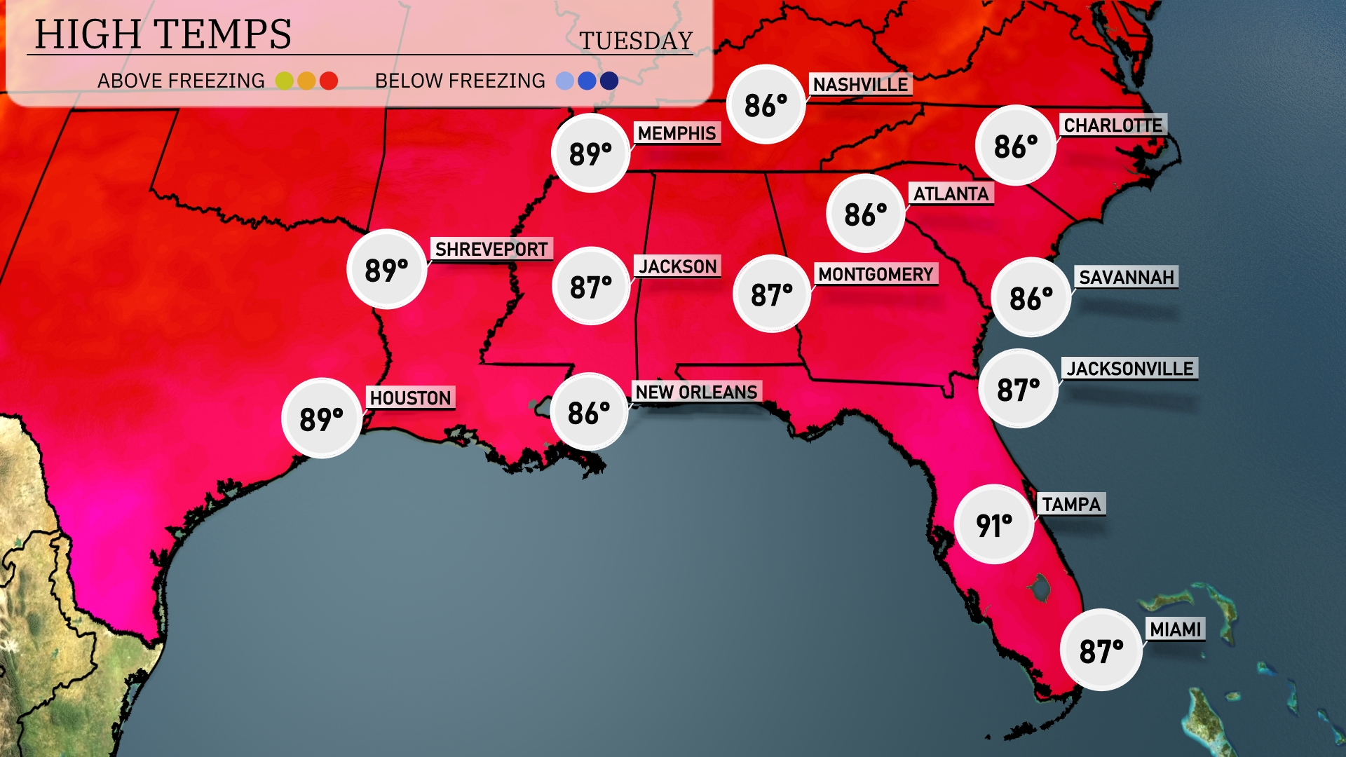
Tomorrow, the Southeast will experience warm temperatures with several cities reaching the upper 80s. Memphis is forecasted to hit 89 degrees, closely followed by Houston at 89 and Jackson at 87. In the Gulf region, New Orleans will see a high of 86, while Tampa is expected to soar to 91 degrees. Expect similar conditions in other parts, with Jacksonville reaching 87 and Atlanta at 86 degrees.
An active weather pattern is setting up for the Southeast as a cold front moves through the region. Showers and thunderstorms, some with heavy rainfall, are anticipated from Houston to New Orleans overnight. As the front progresses, expect scattered storms from Shreveport to Jackson by late Tuesday morning. By the afternoon, storms will intensify over Montgomery and Atlanta, with the potential for localized flooding due to heavy downpours.
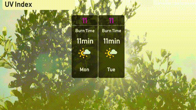
On Monday and Tuesday, the UV index in Miami is very high at 11, leading to a burn time of around 11 minutes under the sun.